1Post-graduation Program in Geochemistry and Geotectonic, Geoscience Institute, Universidade de São Paulo – USP, São Paulo (SP), Brasil. E-mail: [email protected]; [email protected]
2Environmental and Sedimentary Geology Department, Geoscience Institute, Universidade de São Paulo – USP, São Paulo (SP), Brasil. E-mail: [email protected] 3Department of Marine Sciences, Marine Institute, Universidade Federal de São Paulo – UNIFESP, Campus Baixada Santista, Unidade II, Santos (SP), Brasil. E-mail: [email protected]
4Department of Physics, East Carolina University, USA. E-mail: [email protected]
*Corresponding author.
Manuscript ID: 30143. Received: 07/30/2014. Approved: 01/14/2015. ABSTRACT: During the past decades, there have been contrarian explanations for the formation and stabilization of coastal duneields: while many authors believe the dunes formation would be enhan-ced by falling sea level, others argue that a rising or stable sea level context would be favorable. For Brazilian coastal duneields, the se-cond hypothesis seems to be more consistent with the luminescence ages found so far; however, most of these data were obtained wi-thout using the SAR protocol. Another point of concern is the role of climate change in the aeolian system, which is still not very clear. he aim of this paper is to try to clarify these two questions. To this end, ive coastal duneields were selected in central Santa Catarina coast. he remote sensing and dating results allowed the discrimina-tion and mapping of at least four aeolian generadiscrimina-tions. heir age dis-tribution in relation to the global curve of relative sea level variation during the Late Pleistocene allows us to suggest that the formation of Aeolian duneields in the coastal context is supported by stable relative sea level. However, relative sea level is not the only determi-nant for the formation and preservation of the aeolian coastal dunes. Evidences of climatic control indicate that the initiation of duneields would be favored by periods of less humidity while their stabilization would occur preferably during the periods of rain intensiication, connected to monsoon activity.
KEYWORDS: OSL-SAR dating; Dune stabilization; Aeolian generations.
RESUMO: A formação e estabilização de campos de dunas costeiros têm sido explicadas de maneiras contrárias ao longo das últimas déca-das: enquanto alguns autores acreditam que a formação das dunas seria favorecida pelo nível do mar descendente, outros autores defendem que o contexto de nível do mar estável seria mais favorável à sua formação. No caso dos campos de dunas costeiros do Brasil, a segunda hipótese parece ser mais consistente com as idades de luminescência obtidas até o momen-to; no entanto, a maior parte desses dados foi obtida sem o uso do pro-tocolo SAR (Single Aliquot Regenerative dose). Outra questão em aberto seria qual o papel exercido pelas mudanças climáticas no sistema eólico. Este artigo tenta clarear essas duas questões, e para essa inalidade foram escolhidos cinco campos de dunas na costa central catarinense. Os dados de sensoriamento remoto e das datações absolutas permitem a discriminação e mapeamento de pelo menos quatro gerações eólicas. A distribuição das idades encontradas em relação à curva global de variação do nível do mar permite sugerir que a formação dos campos de dunas estaria relacionada com nível do mar estável. Contudo, o nível relativo do mar não é a úni-ca variável determinante no sistema eólico costeiro. Foram encontradas evidências de controle climático, e a formação das dunas estaria ligada a períodos de menor precipitação enquanto sua estabilização ocorreria em momentos de intensiicação das chuvas, ocasionados por aumento nas atividades das monções.
PALAVRAS-CHAVE: Datações LOE-SAR; Estabilização de dunas; Gerações eólicas.
Central Santa Catarina coastal duneields
chronology and their relation to relative
sea level and climatic changes
Cronologia dos campos de dunas da costa central catarinense e a
inluência do nível relativo do mar e das mudanças climáticas
Vinícius Ribau Mendes1*, Paulo César Fonseca Giannini2,
Carlos Conforti Ferreira Guedes3, Regina DeWitt4, Helena Asmar de Abreu Andrade1
INTRODUCTION
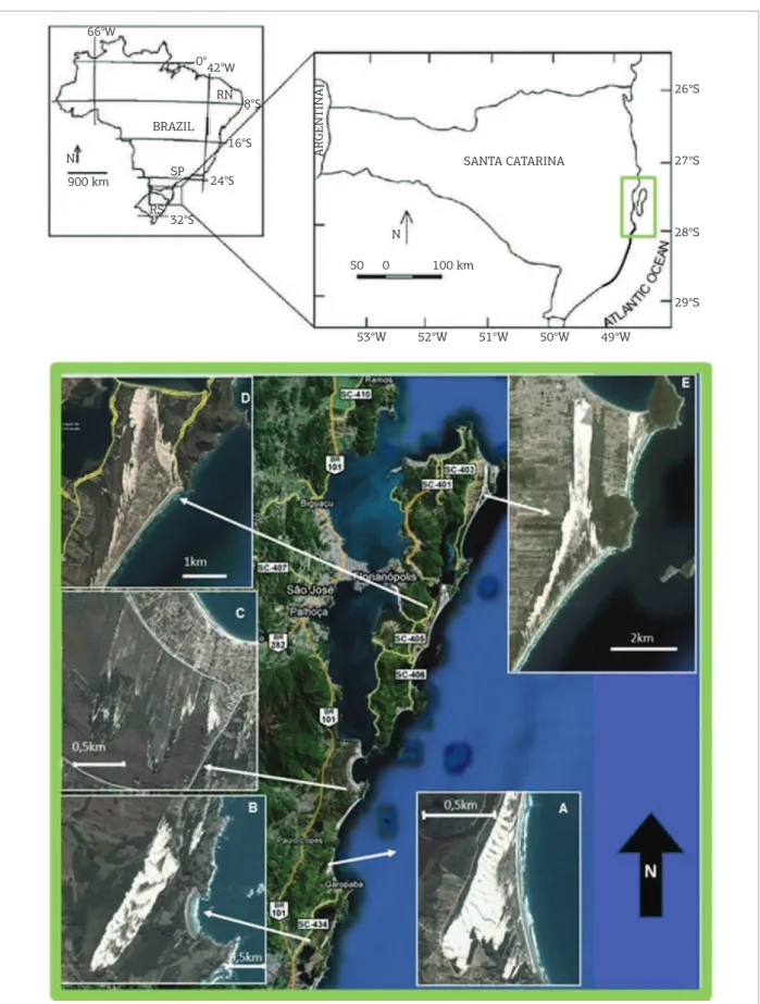
Santa Catarina central coast, between Ouvidor and Florianópolis, has ive active duneields with 1 to 3 km length (Fig. 1). Some of these duneields were previously studied with emphasis on the geomorphology and sedi-mentology of their deposits (Bigarella 1975, Bigarella et al.
2005, Miot da Silva 2006, Hesp et al. 2009, Dillenburg
et al. 2014). No work has been published for this region, focussing on the chronology of duneield evolution through-out the late Quaternary, except for attempts by Hesp et al.
(2009) to distinguish aeolian Holocene pulses in Pinheira strandplain. his kind of focus is becoming more common in both national (Giannini & Suguio 1994, Barbosa 1997, Dillenburg et al. 2006, Giannini et al. 2007, Barreto et al.
2002, 2004, Martinho & Giannini 2001, Claudino-Sales & Peulvast 2002, Sawakuchi et al. 2008) and international research (Pye 1983, Endo 1986, Short 1988, Stokes et al.
1997, Loope & Arbogast 2000, Lees 2006), in particu-lar during the last two decades. he main reasons for the renewed interest in this subject are the possible implications of the diferent generations of aeolian duneields and their time-space distribution for the study of sedimentary supply, climate and relative sea level (RSL) behavior.
Similar studies were performed in the region of Jaguaruna-Imbituba (Giannini 1993, Sawakuchi 2003, Giannini et al.
2007), to the south of the present study area. he results of those studies allowed recognizing at least four dune-ield generations. Morphostratigraphic interpretations, reinforced by the results of luminescence dating in this region, led Giannini et al. (2007) to suggest a model for the formation and preferential preservation of coastal aeo-lian deposits in terminal transgressive and high sea sys-tem tracts. he average ages obtained by luminescence in Santa Catarina centre-south (Giannini et al. 2007) and Rio Grande do Norte (Barreto et al. 2004) are in reasonable agreement. hese results seem to strengthen the hypothe-sis of inter-regional correlation between the generations of Aeolian duneields on the Brazilian coast (Giannini 2007), which would be sea level controlled.
However, one question that arises from this hypothesis of duneield formation deserves some reinement or revi-sion: the two youngest aeolian generations found in Santa Catarina centre-south, in Rio Grande do Norte and in other Brazilian coastal sectors were formed during the last millen-nia, after the Holocene maximum RSL (around 5.5 ky BP). hus, factors that control the coastal duneield dynamics are still not fully understood, since one changes from the tens of thousandsof yearstimescale (in which the inluence of RSL variation of more than 100 m seems relevant) to the millen-nial or decadal scale (in which the RSL variation accounts
only for less than 3 m). Two questions were addressed in the present study: Are the climatic oscillations in southern South America (Cruz et al. 2006, 2007, 2009, Wang et al. 2006, Haylock et al. 2006), which are connected to sub-Milanko-vitch events, such as the Heinrich events (Heinrich 1988) and the Little Ice Age (LIA), the main factors controlling coastal duneield dynamics on a short timescale? Does the beginning and stabilization of duneields mean a deined climate throughout the late Holocene?
To address these questions, the Santa Catarina central coast was chosen for two reasons. Firstly, because the area is immediately adjacent in the north to the region between Imbituba and Jaguaruna, which has been previously sub-ject to the above mentioned studies about stratigraphy and chronology of coastal duneields (Giannini et al. 2007). Secondly, because it covers precisely the limit between the duneields migrating to SW (Fig. 1), that are predominant from Pinheira toward south, and the dunes and blowouts migrating to N to NW, that are found from Pinheira to north in south-southeast Brazil, especially at Santa Catarina island (Hesp et al. 2007) and São Francisco do Sul (Zular 2011), in Santa Catarina State, and at Ilha Comprida (Sawakuchi
et al. 2008, Guedes et al. 2011) in São Paulo State.
REGIONAL SETTING
Geologic and geomorphologic features
he study area is located in the second southernmost phys-iographic-structural sector of the Brazilian coast (Giannini 2007), which stretches with a general NNE orientation from Imbituba (28° 15’ S) to Itajaí-Joinville (26°15’ S). In com-parison with its northern and southern neighbors, this coastal sector is more interrupted by headlands and with a narrower and steeper inner continental shelf (0.07 to 0.26°).26°S
27°S SANTA CATARINA
50 0 100 km
N BRAZIL
RN
SP
RS 900 km
N
0° 42°W 66°W
8°S
16°S
24°S
32°S
ARGENTINA
28°S
29°S
49°W 50°W
51°W 52°W
53°W
Figure 1. Location of the study area. From south to north, it includes Five beach (duneields) systems (A) Barra-Ouvidor (Barra-Ouvidor); (B) Siriú – Morro da Antena (Garopaba); (C) Pinheira – Rio da Madre (Pinheira); (D) Campeche-Conceição (Joaquina); and (E) Moçambique - Ingleses (Ingleses).
the Holocene terrace clearly corresponds to a strandplain, as evidenced by the sets of foredune ridges (Hesp et al. 2009, Barboza et al. 2009, Hein et al. 2013, Dillenburg et al. 2014,
Hein et al. 2014).
Coastal duneields become well developed from the studied area to the south coast of Brazil (Bigarella 1975). Based on stratigraphic, geomorphologic, mineralogical and textural features, Giannini (1993, 2002) and Giannini
et al. (2005) could recognize at least four aeolian dune generations in south Santa Catarina State. Giannini et al. (2007) grouped them in two sequences, indicating a major RSL inluence in their formation and, therefore, a regional expression. he generation 1 (G1) was formed before the last Pleistocene highstand (120 ka). he generation 2 (G2) comprises duneields formed before the Holocene highstand, while generations 3 and 4 (G3 and G4) were formed after this highstand. he diference between these last two gen-erations is that G4 is still active at present.
Santa Catarina coast has more than 30 dated indi-cators of RSL positions during the Holocene, obtained in vermetid (encrusting marine gastropods) remains (Angulo et al. 2006). These data indicate a maximum RSL of 2.1 ± 1.0 m higher than the present RSL, reached
5916-5597 14C cal years before present (BP) (Angulo et al. 2006).
Climate and oceanography
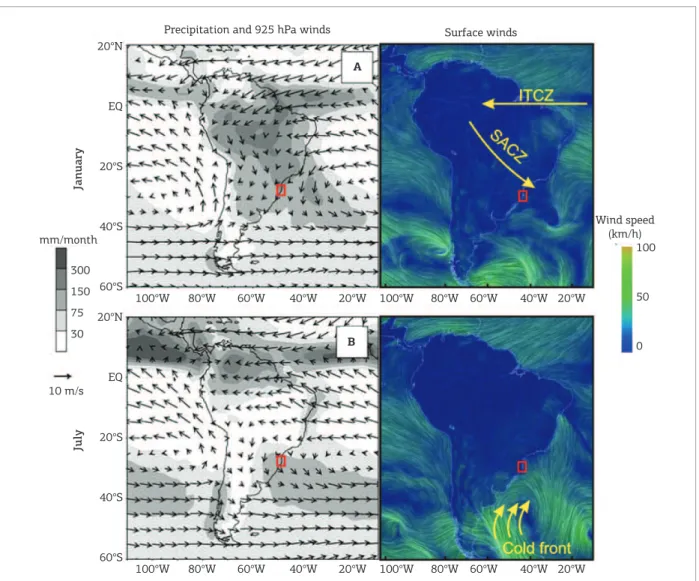
According to Cruz et al. (2006, 2009) and Garreaud
et al. (2009), there are two important sources for the moisture involved in southern South America precipi-tation. The first one, named South American Monsoon System (SAMS), is related to the Intertropical Convergence Zone (ITCZ) and the South Atlantic Convergence Zone (SACZ), and is intensiied during austral summer. It has major importance for the rainfall in most of South America, being responsible for approximately 60% of Santa Catarina state precipitation (Cruz et al. 2007). he second source of moisture, called frontal system (cold fronts), is responsible for the winter rains and reaches the Brazilian south and south-east coast. hese climatic phenomena result from migratory cyclones along the subtropical Atlantic coast (Vera et al. 2002). Both climatic systems afect the wind patterns (Fig. 2): the stronger S winds are associated with the cold front system, as the intensiication of SACZ pushes the N wind ofshore. Imbituba’s harbor tidal board marks the mean astronom-ical tide oscillation at 0.6 m within a semi-diurnal regime (Giannini 1993). Based on the records (2002–2003) of the Arvoredo Island, located 35 km ofshore from the island of Santa Catarina, Hesp et al. (2009) identiied two trends in the signiicant wave height and direction distribution of swells arriving at the central coast of Santa Catarina. he irst trend, most common and related to large-scale
climatic phenomena, is represented by swells from S (17), with an average period of 12s and height of 1.0 to 1.5 m. he second one is related to air masses generated locally and translates into waves coming from ENE (70° azimuth), with a 7 s mean period and up to 1.0 m height.
Geomorphological, granulometric and mineralogical evidences, applied in diferent beaches in the sector between Laguna and Imbituba (Giannini 1993, 2002, 2007, Martinho
et al. 2006), indicate predominance of net longshore sedi-ment transport from S-SW to N-NE.
MATERIALS AND METHODS
Remote sensing
Aerial photographs and satellite imagery were used to identify aeolian morphologic elements and to map mor-phostratigraphic units (possible generations of aeolian deposits). he historical series of aerial photographs includes the years 1938 (available only for the Ingleses, Joaquina and Pinheira duneields), 1957 and 1978. hese photos were geo-referenced and compared with each other and with satellite images (2001 to 2009) from the Google Earth® software.
OSL dating
he OSL method was applied to quartz grains from 13 sand samples, 11 of which are aeolian paleodunes, and 2 are marine constructive terraces. hese samples were selected among 119 samples collected during the ieldwork. he sam-ple preparation followed the standard coarse-grain quartz extraction procedure, including treatment with HCl and H2O2, etching with HF, and density separation, all under red light.
he OSL-SAR procedure described by Murray and Wintle (2000) and Wintle and Murray (2006) was applied to quartz grains of 120 – 150 µm diameter, which is the most accepted procedure for the determination of the radiation dose accumu-lated in quartz grains. he luminescence signals were measured with a Risø DA-15 TL/OSL system at the Radiation Dosimetry Lab at Oklahoma State University – USA. he 90Sr/90Y beta
source attached to this equipment provided a dose rate of 93.2 ± 4.1 mGy/s. he heating rate used was 5°C/s, and all
RESULTS
OSL dating
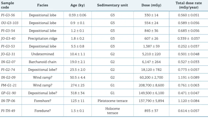
Out of the 11 OSL ages obtained from aeolian sam-ples, ive belong to G3, four to G2 and two to G1. Out of the two OSL ages from marine terraces, one is Pleistocene (IN-TP-06) and the other is Holocene (PI-TH-49, Tab. 1).
he G1 samples present two ages that overlap within error limits, with a range between 350 to 240 ky. he four ages present in G2 appear distributed over three age ranges. he oldest one comprises one sample and is located around 50 ky. he second range comprises two samples, around 21 ky, and the last range has one sample of about 10 ky.
he ive dates for G3 are distributed over two temporal ranges, the irst and oldest one is 5.5 ± 0.8 ky. he second
temporal range comprises four samples and is almost con-tinuous, from about 1,900 to 600 years. here is a hiatus between these ranges at around 2.5 ky.
Distribution of the
Quaternary sedimentary units
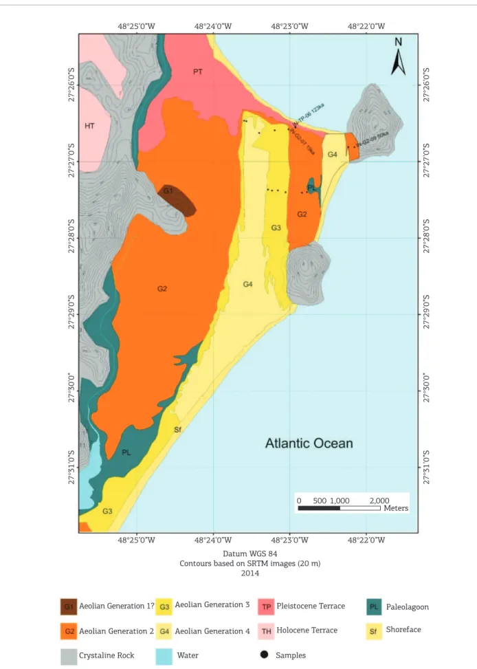
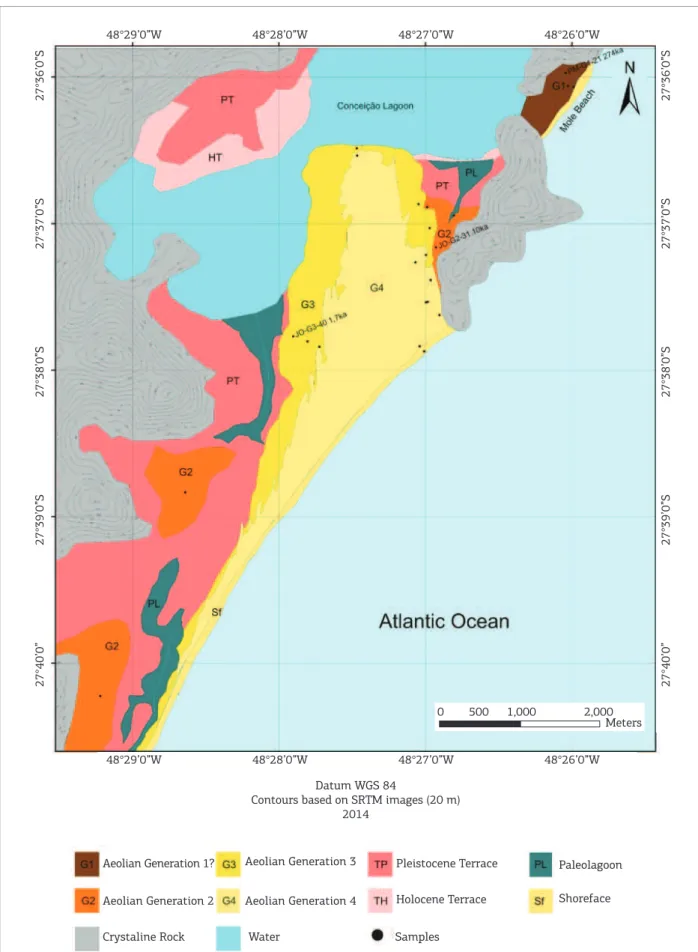
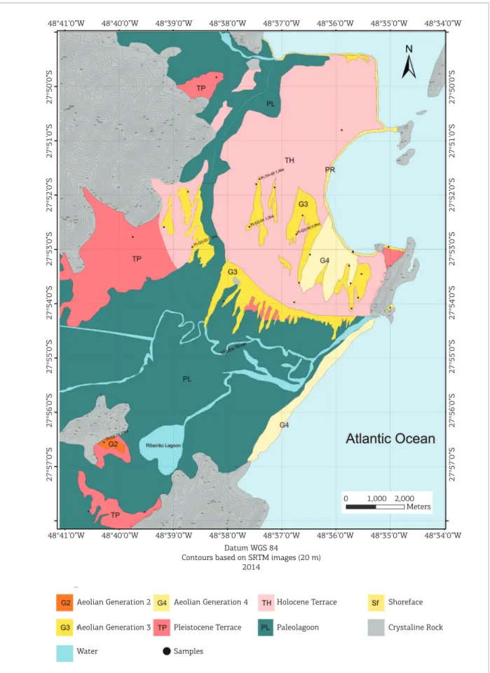
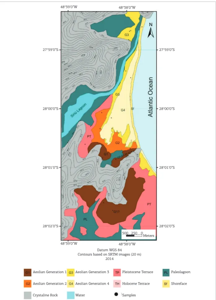
he Quaternary aeolian sedimentation of Santa Catarina central coast can be divided into four generations (Figs. 3 to 7), matching the ones observed by Giannini et al. (2007).
he oldest generation G1 occurs associated with crys-talline rock hills (Figs. 3, 4 and 6). It appears dissected by drainages so the aeolian features are not recognizable
Precipitation and 925 hPa winds Surface winds
20°N
EQ
20°S
January
July
40°S
60°S 300 mm/month
150
75
30
10 m/s
100°W 80°W 60°W 40°W 20°W 100°W 80°W 60°W 40°W 20°W
20°N
EQ
20°S
40°S
60°S
100°W 80°W 60°W 40°W 20°W 100°W 80°W 60°W 40°W 20°W
Wind speed (km/h)
100
50
0 A
B
Figure 2. Precipitation and 925 hPa wind map (let) and surface winds (right) for South America. Squares show the study area. During austral summer, (A) the SACZ is intensiied and pushes the northern winds ofshore; on the other hand, during austral winter, (B) the cold fronts and the associated southern winds (let maps modiied from Garreaud et al. 2009; right images modiied from http://earth.nullschool.net).
neither in satellite images and aerial photos, nor in the ield. In the Ingleses duneield area (Fig. 3) and at the south portion of Garopaba region (Fig. 6), the identiication of G1 was mostly based on morphologic criteria (absence of depositional forms) as suggested by Giannini et al.
(2007). In the Joaquina duneield area (Fig. 4) and in the north portion of Garopaba (Fig. 6), G1 was also indi-cated by OSL dates. he new information found in the present study, compared to what had been described so far for this generation, is the existence of ages older than the last Pleistocene highstand (about 120 ky). hese ages (274 ± 25 and 318 ± 34 ky, respectively Fig. 4 and 6) are
also the oldest found for Quaternary sedimentary coastal deposits in all of the south and southeast Brazilian coast, at least for published OSL-SAR dating results.
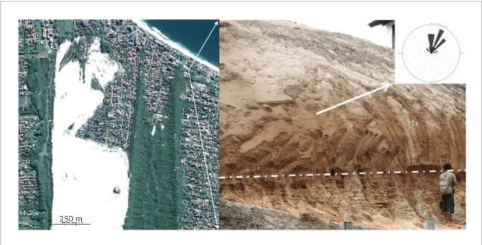
G2 occurs as softly wavy terrain (undulations about 3 m high and 150 m long), with a medium altitude around 25 m, covering the Pleistocene terraces from 10 m high, attributed to the high RSL of 120 ky BP. As far as area is concerned, it is the most representative aeolian generation for the region and represents G3 and G4 substrate in the Ingleses (Fig. 3), Joaquina (Fig. 4) and Garopaba (Fig. 6) duneields, although aeolian features cannot be recog-nized in the morphology there. However, it was possible to identify sedimentary structures typical of wind depo-sition in outcrops, i.e., trough cross stratiications, in sets up to 3 m thick (Fig. 8). he festoon cross-stratiication
pattern, found in the section WNW-ESE, is compatible with the migration direction of the barchanoid aeolian chains, which is SSW_NNE in this region. Eighteen measurements of cross stratiication conirm the domi-nance of an N 17º direction paleowind. Waved terrains with similar characteristics, and with possible tenuous parabolic shapes in aerial photos, were already described in the regions of Imbituba and Jaguaruna, center-south littoral of Santa Catarina, by Giannini (1993), who clas-siied them as G2.
G3 has a well preserved aeolian morphology and it is found in the surroundings of active duneields (G4) as pre-cipitation ridges with a parallel orientation to the present duneield (Fig. 8). An exception is in Pinheira, where dif-ferent G3 duneield pulses appear dispersed on the south portion of Holocene strandplain (Fig. 5). Stratigraphically, G3 occurs over the pre-Cenozoic crystalline basement, above the Pleistocene marine terrace and, to a greater extension, above the sandy terrain of wavy surface identiied as G2.
he active duneields (G4) show a spatial distribution related to the G3 deposits, which are sometimes partially overlapped by them. G4 appears surrounded almost exclu-sively by G3 and sufers a stabilization process by vegeta-tion growth in the delavegeta-tion zone, and by the consequent reduction of sedimentary supply for the more distal wind features, such as depositional frontal lobes and precipitation ridges (Mendes & Giannini 2015).
Table 1. Relation of the dated samples with the corresponding depositional facies, ages, associated error and sedimentary units
Sample
code Facies Age (ky) Sedimentary unit Dose (mGy)
Total dose rate (mGy/year)
PI-G3-56 Depositional lobe 0.59 ± 0.06 G3 330 ± 14 0.560 ± 0.051
OU-G3-103 Depositional lobe 0.9 ± 0.1 G3 554 ± 24 0.589 ± 0.056
PI-G3-54 Depositional lobe 1.2 ± 0.1 G3 840 ± 36 0.683 ± 0.056
JO-G3-40 Precipitation ridge 1.8 ± 0.2 G3 607 ± 26 0.339 ± 0.037
PI-G3-53 Depositional lobe 5.5 ± 0.8 G3 1,387 ± 59 0.252 ± 0.037
JO-G2-31 Undetermined 10.4 ± 1.1 G2 5,210 ± 220 0.501 ± 0.048
IN-G2-07 Barchanoid chain 19.0 ± 2.1 G2 6,147 ± 264 0.327 ± 0.033
PI-G2-74 Depositional lobe? 23.5 ± 2.0 G2 18,120 ± 782 0.773 ± 0.057
IN-G2-09 Wind ramp? 50.5 ± 4.4 G2 60,200 ± 2,700 1.191 ± 0.089
PM-G1-21 Wind ramp? 274 ± 25 G1 208,700 ± 8,600 0.761 ± 0.063
GP-G1-90 Depositional lobe? 318 ± 34 G1 149,500 ± 6,100 0.471 ± 0.047
IN-TP-06 Foreshore? 123 ± 11 Pleistocene terrace 137,790 ± 5,894 1.120 ± 0.084
PI-TH-49 Foredune? 1.5 ± 0.1 Holocene
48°25’0”W
27°26’0”S
27°27’0”S
27°28’0”S
27°29’0”S
27°30’0”
27°31’0”S
27°26’0”S
27°27’0”S
27°28’0”S
27°29’0”S
27°30’0”
27°31’0”S
48°24’0”W 48°23’0”W 48°22’0”W
48°25’0”W 48°24’0”W 48°23’0”W
Datum WGS 84
Contours based on SRTM images (20 m) 2014
Aeolian Generation 1?
Aeolian Generation 2
Crystaline Rock Water Samples
Holocene Terrace
Pleistocene Terrace Paleolagoon
Shoreface Aeolian Generation 4
Aeolian Generation 3
0 500 1,000 2,000
Meters
48°22’0”W
48°29’0”W
27°36’0”S
27°37’0”S
27°38’0”S
27°39’0”S
27°40’0”
27°36’0”S
27°37’0”S
27°38’0”S
27°39’0”S
27°40’0”
48°28’0”W 48°27’0”W 48°26’0”W
48°29’0”W 48°28’0”W 48°27’0”W 48°26’0”W
Datum WGS 84
Contours based on SRTM images (20 m) 2014
Aeolian Generation 1?
Aeolian Generation 2
Crystaline Rock Water Samples
Holocene Terrace
Pleistocene Terrace Paleolagoon
Shoreface Aeolian Generation 4
Aeolian Generation 3
0 500 1,000 2,000
Meters
48°41’0”W 48°40’0”W 48°39’0”W 48°38’0”W 48°37’0”W 48°36’0”W 48°35’0”W 48°34’0”W
48°41’0”W 48°40’0”W 48°39’0”W 48°38’0”W 48°37’0”W 48°36’0”W 48°35’0”W 48°34’0”W
27°50’0”S
27°51’0”S
27°52’0”S
27°53’0”S
27°54’0”S
27°55’0”S
27°56’0”S
27°57’0”S
27°50’0”S
27°51’0”S
27°52’0”S
27°53’0”S
27°54’0”S
27°55’0”S
27°56’0”S
27°57’0”S
Datum WGS 84
Contours based on SRTM images (20 m) 2014
Aeolian Generation 2
Crystaline Rock
Water Samples
Holocene Terrace
Pleistocene Terrace Paleolagoon
Shoreface Aeolian Generation 4
Aeolian Generation 3
0 1,000 2,000 Meters
48°39’0”W 48°38’0”W
48°39’0”W 48°38’0”W
28°00’0”S
28°01’0”S
28°02’0”S 27°59’0”S
28°00’0”S
28°01’0”S
28°02’0”S 27°59’0”S
Datum WGS 84
Contours based on SRTM images (20 m) 2014
Aeolian Generation 2 Aeolian Generation 1
Crystaline Rock Water Samples
Holocene Terrace
Pleistocene Terrace Paleolagoon
Shoreface Aeolian Generation 4
Aeolian Generation 3
0 500 250
Meters
40°40’0”W 40°41’0”W
0°S
0°S
0°S
0°S
0°S
0°S
48°39’0”W 48°38’0”W
40°40’0”W
40°41’0”W 48°39’0”W 48°38’0”W
Datum WGS 84
Contours based on SRTM images (20 m) 2014
Aeolian Generation 2?
Crystaline Rock
Water Samples
Holocene Terrace
Pleistocene Terrace Paleolagoon
Shoreface Aeolian Generation 4
Aeolian Generation 3
0 1,000
2,000
Meters
Figure 7. Distribution of the Quaternary sedimentary units for the Ouvidor duneield area. The dated samples are labeled with the sample name and the OSL age.
The paleolagoon corresponds to the area where the Pleistocene terrace and its overlapping G2 paleodunes have been drowned (and subsequently silted) since the Holocene maximum inundation. It appears to have formed preferably in locations with incised drainages
DISCUSSIONS
Geological significance
of OSL ages in aeolian deposits
In theory, the OSL age represents the time of sediment burial and, if obtained from the most distal depositional lobe of the duneield, it provides a good estimate for the stabi-lization of the aeolian system. Nevertheless, depending on the uncertainty of the OSL method and the duration (“life-time”) of the duneield active period, there is a probability that the time frame obtained with OSL does not only include the stabilization (“death”) of the duneield but also its initia-tion (“birth”). he greater the sand volume of the duneield, the longer is its active period. herefore, in relatively small coastal duneields as the ones studied here, the life-time of the aeolian system tends to be shorter than the precision of the OSL dating method (like few hundred years), which for our samples is close to 10%, so the duneield initiation can be included in the age as well as the stabilization. his should be viewed therefore as a general premise to the two following topics of discussion.
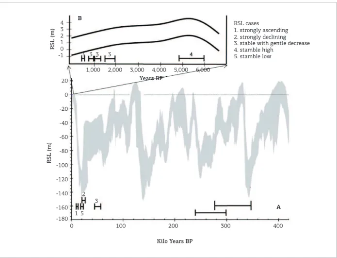
Age distribution in relation to RSL variations
he aim was to characterize the RSL behavior during the periods that coincide with the obtained OSL ages of the aeolian
dunes. Five situations were distinguished, using the available OSL results (Fig. 9):
1. strongly ascending RSL;
2. strongly declining RSL;
3. stable RSL with gentle decrease;
4. stable high RSL linked to tendency inversion (positive peak of the variation curve); and
5. stable low RSL, linked to tendency inversion (negative peak of the variation curve).
From the nine available youngest OSL ages, and consider-ing the respective error margins, the distribution of the ages is as follows: one in the case 1, one in the case 2, ive in the case 3, one in the case 4 and one in the case 5. he two oldest ages have too large error margins and therefore it several cases at the same time, making their classiication regarding RSL behavior ambiguous. As mentioned in section “Geological signiicance of OSL ages in Aeolian deposits”, this is an inherent limita-tion of OSL dating, since the error grows proporlimita-tionally with the determined age.
here is a clear predominance of stable RSL cases (seven cases out of nine), mainly in gentle decrease but also in ten-dency of inversion. Five out of these seven cases refer to dunes formed with an RSL similar to the present, in a variation margin of about 3 m, all posterior to the last transgressive maximum (G3). his high representation of G3 dunes is
250 m
Figure 8. Aerial and outcrop aspects of the main depositional lobe in the Ingleses duneield. Let: G3 precipitation
ridges parallel to the G4 (active) duneield (image from Google Earth®). Right: Contact (highlighted by the
surely caused by a sampling bias. Stabilized dunes formed with high RSL, similar to the present, and at coast lines close to the present ones are more or better exposed at the present coastal zone than dunes formed under RSL and at coast line positions very discrepant from the present ones (Giannini 2007, Giannini et al. 2007, Guedes 2012). heir presence can be favored also by a preservation bias, where more recent deposits generally are better preserved than older ones.
Nevertheless, stable RSL conditions are as predominant among the younger ages (G3) as among the oldest ages (G2). So, stable RSL seems to be in fact an efective controlling fac-tor for aeolian dune formation and/or preservation. A point in favor of the possible connection between stable RSL and aeo-lian supply, defended by Giannini et al. (2001, 2007), is the maintenance of the distance between the forming duneields and their source areas at the coastline. he stability of this dis-tance would constitute a favorable factor in the formation or
maintenance of the active duneields. he authors’ argument is that the stability of the coastline, not assured but favored by a stable RSL, is a necessary condition for the activity of the aeolian system, since wind transport and deposition dilute throughout a wide coastal area,if the coastline varies quickly.
he deposits of the two oldest generations were reached by the sea during the two latest maximum loodings of the Brazilian coast (Giannini 1993). Giannini (2007) and Giannini
et al. (2007) considered this as evidence that these generations were formed, at least partially, under a transgressive terminal context (shortly before the maximum inundation). hey based this assumption on the premise that, because these paleodunes are close to the present coast, they were generated at similar shorelines and RSL as present. In these authors’ model, the two youngest generations, attributed to the regression that followed the maximum Holocene lood, would have still formed in the same high RSL context responsible for the
0 100 200 300 400
Years BP
Kilo Years BP
1,000 4
20
0
-20
-40
-60
-80
-100
-120
-140
-160
-180 3 2 1 0 -1
2,000 3
3
5 1
2 3 3
3 4
3,000 4,000 5,000 6,000
RSL cases
1. strongly ascending 2. strongly declining 3. stable with gentle decrease 4. stamble high
5. stamble low
RSL (m)
RSL (m)
A B
Figure 9. Global (A) adapted from Rabineau et al.2006) and Brazilian (B) adapted from Angulo et al.2006) RSL
previous generations, however without reaching such inter-nalization. Following the reasoning of the favorability of the shoreline stability in the formation of duneields, proposed by Giannini (2007) and Giannini et al. (2007), the stable shoreline periods, during glacial maxima, and therefore with a low RSL, would also be favorable to the development of coastal aeolian systems (Guedes 2012).
However, there is a relative higher diiculty for the for-mation of coastal duneields during high sea level, when com-pared to ones formed during low sea level, which relates to the relative duration of the RSL maintenance. At least during the last million years of Earth history, when Milankovitch orbital cyclicity is dominated by the component of eccen-tricity variation, with time periods around 100 thousand years, the interglacial periods are shorter in time than the glacial (Ruddimann 2008). herefore, the high RSL periods are also less durable than the low RSL periods. hat means that the proitable time to accumulate big aeolian deposits with coastal source is much shorter under high sea condi-tions than under low sea level condicondi-tions.
Another exception to the model of predominance of aeolian dunes under high RSL relates to the preservation question. Due to the cyclic character of the RSL varia-tions, connected to the succession of glacial and intergla-cial stages, a duneield formed under high RSL conditions tends to be, in the passage to a new glacial stage, submit-ted to a substantial fall of the base level of erosion, due to the lowering of RSL and groundwater. his base level fall would hinder the preservation of its deposits for a long time, i.e., for a time compatible with an eccentricity cycle. Duneields formed under a high RSL would be more sub-ject to subaerial erosion, mainly because of the subsequent RSL fall (forced regression). On the other hand, the deposits formed during a low RSL could be reworked by the shore-line transgression. Meanwhile, if that transgression is a result of the RSL rise with a high rate, only the supericial aeolian deposits would be reworked, which would consid-erably increases their preservation potential in geological time (Guedes 2012).
Age distribution in
relation to climate variations
Nine from the 11 dated aeolian dunes have their age distribution analyzed in relation to the more accepted cli-mate variations during the last 120 ky (there are no climatic reconstructions for the period of the two oldest samples). he OSL ages were plotted inside graphics of δ18O variation
over time, obtained in southern Brazil speleothems (Figs. 10 and 11). In these graphics, the more negative isotope ratio values, connected to the rain amount efect, result from the SAMS intensiication and, therefore, they are correlated
with greater atmospheric humidity values (Cruz et al. 2006, 2007, 2009). he aeolian ages distribution analysis was made separately in two diferent timescales. In the irst and most embracing, corresponding to only ive of the older samples, the ages are all related to climate transition moments, from less to more humid and/or humidity minima followed by humidity maxima (Fig. 10).
Transition periods, with a humidity increase, and con-sequently with a sand moisture increase, and periods of minimum moisture followed by its quick increase would be favorable to the development and stabilization of aeo-lian dunes for two main reasons. he irst, connected to the duneield formation, would be the decrease of the veg-etation cover, with the resulting encouragement of wind transport (Carter 1990, Hesp & hom 1990, Hesp 2000). he second reason, connected to the stabilization of the aeo-lian dunes, would be a possible reduction of wind intensity with rain increase. Similar efect is observed in the recent stabilization of the central coastal dunes of Santa Catarina (Miot da Silva & Hesp 2013, Mendes & Giannini 2015) and medium north of Rio Grande do Sul (Martinho et al.
2010). Weather data from the last century points to the rise of the annual precipitation associated with a decrease of the wind intensity as the main control factor of stabiliza-tion observed on the duneields of the Santa Catarina coast. In this context, the dune stabilization would be supported by the combined efects of:
1. the vegetation grown and/or development of wetlands on the delation zones;
2. the increase of the transportation threshold due to the sand cohesion induced by the moisture increase; and
3. the decrease of the wind intensity (Mendes & Giannini 2015). Low 1 0 -1 -2 -3 -4 -5 -6
0 10 20 30 40
Kilo years
50 60 70
High Humidity δ18 O (% 0 VPDB) Bt2 OSL ages
Angulo R., Lessa G.,Souza M. 2006. A critical review of mid- to
late-Holocene sea-level luctuations on the eastern Brazilian coastline. Quaternary Science Reviews, 25(5-6):486-506.
Barbosa L.M. 1997. Campos de dunas costeiras associados à desembocadura do Rio São Francisco (SE/AL). Tese de Doutoramento (inédita), Instituto de Geociência, Universidade Federal da Bahia, Salvador, 202 p.
Barbouti A.I. & Rastin B.C. 1983. A study of the absolute intensity of muons at sea level and under various thicknesses of absorber. Journal of Physics G: Nuclear Physics, 9(12):1577.
Barboza E.G., Dillenburg S.R., Rosa M.L.C.C., Tomazelli L.J., Hesp
P.A. 2009. Ground-penetrating Radar Proiles of Two Holocene
REFERENCES
Regressive Barriers in Southern Brazil. Journal of Coastal Research,
SI 56:579-583.
Barreto A.M.F., Suguio K., Bezerra F.H.R., Tatumi S.H., Yee M., Giannini P.C.F. 2004. Geologia e geomorfologia do quaternário costeiro do estado do Rio Grande do Norte. Geologia USP. Série Cientíica, 4:1-12.
Barreto A.M.F., Suguio K., Bezerra F.H.R., Tatumi S.H., Yee M., Oliveira P.E. 2002. Datação de dunas costeiras inativas do Estado da Paraíba por métodos de luminescência. In: Congresso Brasileiro de Geologia, 41, João Pessoa, PB, Anais... João Pessoa, SBG, p. 351.
Bigarella J.J. 1975. Lagoa dune ields (State of Santa Catarina,
Brazil), a model of eolian and pluvial activity. Boletim Paranaense de notícias, 33:133-167.
he second timescale is comprised inside the irst one as slight oscillations, representative of the secular climate change. It is observed more easily during the three last mil-lennia, corresponding to G3. he error involved in the dates is from about hundred to tens of years. On this timescale, three of the four youngest OSL ages include falling or neg-ative peaks of humidity, with humidity increase in the end (Fig. 11), a pattern similar to that found in the irst times-cale (Fig. 10). his way, the mechanism of climate control for the formation and stabilization of dunes inferred from the longer timescale would also act on this shorter times-cale. his coincidence implies, as a general rule, that the duneields would be generated during moments of mon-soon weakening and stabilized during its intensiication.
Summarizing, in the climate variation context, the dune-ields would be preferentially formed during the less humid climate moments, connected to the weakening of the mon-soons, and stabilized during the subsequent more humid moments, of monsoon strengthening. Based on the available OSL-SAR ages, this pattern is apparently valid, both on the tens of thousands of years scale, as on the last thousands of
years scale, when the peaks of less humidity can be repre-sented, for example, by MCA and CWP (Fig. 11), and on the most humidity ones, by the Bond events and the LIA.
CONCLUSIONS
Based on the results obtained and discussed in this arti-cle, the main conclusions can be summarized as follows:
1. Four aeolian generations are recognizable based on remote sensing, ield work and OSL dating. hey are correlated with the generations previously deined for the center-south coast of Santa Catarina and possibly extendable to other coastal regions with aeolian duneields in Brazil.
2. Based on the OSL ages, it is possible to infer at least three stages of dune formation inside the older gene-ration (G1), which would correspond to high relative sea levels since the Late Pleistocene highstand (120 ky). herefore, from the chronology point of view, the G1 unit could be divided into three units.
3. he relation between the aeolian generations age distribu-tion and the global curve of RSL variadistribu-tion during the Late Pleistocene allows to suggest that the formation of aeolian duneields of coastal context is favored by stable RSL, and their preservation is helped by the subsequent increase of RSL. However, RSL clearly is not the only determinant for the formation and preservation of the aeolian coastal dunes, given the evidences of climatic control. he formation of duneields would be favored by periods of less humidity while their stabilization would occur preferably during the periods of rain intensiication, connected to monsoon activity.
ACKNOWLEDGMENTS
To FAPESP, processes2009/53988-8 and 2009/54232-4; CAPES; and CNPq, process 149544/2010-3.
Figure 11. Distribution of the dated samples (ages
with error bars) in relation to the high resolution δ18O
record, from the Cristal Cave (about 300 km NNW from study site) (adapted from Vuille et al. 2012).
Low -2 -3 -4 -5 -6 -7 -8
0 200 400 600 800 1000 1200 1400 1600 1800 2000 Year (AD/BC)
MCA PIG CWP High Humidity δ18 O (% 0 VPDB) OSL ages Cristal cave
Bigarella J.J., Klein A.H.F., Menezes J.T., Vintém G. 2005. Sub-Tropical Coastal Dunes: Examples from Southern Brazil. Journal of Coastal Research, SI42:113-137.
Carter R.W.G. 1990. The geomorphology of coastal dunes in Ireland. In: Bakker T.W., Jungerius P.D., Klijn J.A. (eds.). Dunes of the European Coasts: Geomorphology -Hydrology - Soils. Germany, Elsevier, p. 31-40.
Claudino-Sales, V. & Peulvast J.P. 2002. Dunes generations and ponds on the coast of Ceará, North-East Brazil. In: Allison R. (ed.) Applied Geomorphology. London, John Wiley & Sons, p. 421-440.
Cruz Jr.F.W., Burns S.J., Jercinovic M., Karmann I., Sharp W.D., Vuille M. 2007. Evidence of rainfall variations in Southern Brazil from trace element ratios (Mg/Ca and Sr/Ca) in a Late Pleistocene stalagmite. Geochimica et Cosmochimica Acta, 71(9):2250-2263.
Cruz Jr.F.W., Burns S.J., Karmann I., Sharp W.D., Vuille M. 2006. Reconstruction of regional atmospheric circulation features during the late Pleistocene in subtropical Brazil from oxygen isotope composition of speleothems. Earth and Planetary Science Letters, 248(1-2):495-507.
Cruz Jr. F.W., Vuille M., Burns S.J., Wang X., Cheng H., Werner M., Lawrence Edwards R., Karmann I., Auler A.S., Nguyen H. 2009. Orbitally driven east-west antiphasing of South American precipitation. Nature Geosciences, 2(3):210-214.
Dillenburg S.R., Barboza E.G. 2009. Long- and short term progradation of a regressive barrier in southern Brazil. Journal of Coastal Research,
SI 56:599-601.
Dillenburg S.R., Barboza E.G., Hesp P.A., Rosa M.L.C.C., Angulo R.J., Souza M.C., Giannini P.C.F., Sawakuchi A.O. 2014. Discussion: Evidence for a transgressive barrier within a regressive strandplain system: implications for complex response to environmental change, by Hein (2013), Sedimentology 60:469-502. Sedimentology, Amsterdam. Print, 61:2205-2212.
Endo K. 1986. Coastal sand dunes in Japan.In: Proceedings of the Institute of Natural Sciences. Nihon University, n. 21, 37-54.
Garreaud R.D., Vuille M., Compagnucci R., Marengo J. 2009. Present-day South American climate. Palaeogeography, Palaeoclimatology, Palaeoecology, 281(3-4):180-195.
Giannini P.C.F. 1993. Sistemas Deposicionais no Quaternário Costeiro entre Jaguaruna e Imbituba, SC. Tese de Doutoramento (inédita), Instituto de Geociências, Universidade de São Paulo, São Paulo, 2 v., 2 mapas, 439 p.
Giannini P.C.F. 2002. Complexo lagunar centro-sul catarinense, valioso patrimônio sedimentológico, arqueológico e histórico. In: Sítios Geológicos e Paleontológicos do Brasil, n.75, pp.213-222.
Giannini P.C.F. 2007. Sistemas deposicionais eólicos no Quaternário costeiro do Brasil. Tese de Livre-Docência (inédita), Instituto de Geociências, Universidade de São Paulo, São Paulo, 205p.
Giannini P.C.F. & Suguio K. 1994. Diferenciação entre gerações de depósitos eólicos quaternários na costa centro-sul de Santa Catarina. In: Congresso Brasileiro de Geologia, 38, Balneário Camboriú, SC. Resumos Expandidos... Balneário Camboriú, SBG. p.402-403.
Giannini P.C.F., Sawakuchi A.O., Martinho C.T. 2001. A estratigraia
de seqüências na evolução das dunas costeiras de Santa Catarina, sul do Brasil. In: Congresso do Quaternário dos Países de Língua Ibérica, Lisboa, Portugal. Actas...pp.117-120.
Giannini P.C.F., Assine M.L., Barbosa L., Barreto A.M.F., Carvalho A.M., Claudino-sales V., Maia L.P., Martinho C.T., Peulvast J.P., Sawakuchi A.O., Tomazelli L.J. 2005. Dunas e paleodunas eólicas costeiras e interiores. In: Souza C.R.G., Suguio K., Oliveira P.E., Oliveira. A.M. (eds.) Quaternário do Brasil (capítulo 11). Abequa, ANP, FAPESP, IG, UnG. Ribeirão Preto, SP, Holos Editora, p.235-257.
Giannini P.C.F., Sawakuchi A.O., Martinho C.T., Tatumi S.H. 2007. Eolian depositional episodes controlled by Late Quaternary relative sea level changes on the Imbituba-Laguna coastal zone (southern Brazil). Marine Geology, 237:143-168.
Guedes C.C.F., Giannini P.C.F., Sawakuchi A.O., Dewitt R., Nascimento D.R., Aguiar V.A.P., Rossi M.G. 2011. Determination of controls on Holocene barrier progradation through application of OSL dating: The Ilha Comprida Barrier example, Southeastern Brazil. Marine Geology, 285:1-16
Guedes C.C.F. 2012. Cronologia e sedimentologia dos depósitos eólicos quaternários do leste maranhense. Tese de Doutoramento, Instituto de Geociências, Universidade de São Paulo, 115p. + 7 anexos.
Haylock M.R., Peterson T.C., Alves L.M., Ambrizzi T., Anunciação Y.M.T., Baez J.,
Barros V.R., Berlato M.A., Bidegain M., Coronel G., Corradi V., Garcia V.J.,
Grimm A.M., Karoly D., Marengo J.A., Marino M.B., Moncunill D.F., Nechet D., Quintana J., Rebello E., Rusticucci M., Santos J.L., Trebejo I., Vincent L.A. 2006. Trends in Total and Extreme South American Rainfall in 1960-2000 and Links with Sea Surface Temperature. Journal of Climate, 19(8):1490-1512.
Hein C.J., Fitzgerald D.M., Cleary W.J., Albernaz M.B., De Menezes J.T., Klein A.H.F. 2013. Evidence for a transgressive barrier within a regressive strandplain system: Implications for complex coastal response to environmental change. Sedimentology, 60(2):469-502.
Hein C.J., Fitzgerald D.M., Klein A.H.D.F., Albernaz M.B., Menezes J.T., Cleary W.J. 2014. Reply to the Discussion by Dillenburg et al. on “Evidence for a transgressive barrier within a regressive strandplain system: implications for complex response to environmental change”, by Hein et al. (2013), Sedimentology 60:469-502. Sedimentology, 61(7):2213-2217.
Heinrich H. 1988. Origin and consequences of cyclic ice rating
in the northwest Atlantic Ocean during the past 130,000 years. Quaternary Research, 29:142-152.
Hesp P., Abreu de Castilhos J., Miot da Silva G., Dillenburg S., Martinho C.T., Aguiar D., Antunes G. 2007. Regional wind ields and duneield
migration, southern Brazil. Earth Surface Processes and Landforms, 32(4):561-573.
Hesp P.A. & Thom B.G. 1990. Geomorphology and evolution of active
transgressive duneields. In: Nordstrom K.F., Psuty N.P., Carter R.W.G. (eds). Coastal Dunes: Form and Process. Chichester, John Wiley & Sons Ltd.
Hesp P.A. 2000. Coastal Sand Dunes. Form and Function. Massey, Massey University, 28p.(CDNV Technical Bulletin, 4).
Hesp P.A., Giannini P.C.F., Martinho C.T., Miot da Silva M.G., Asp Neto N.E. 2009. The Holocene barrier system of the Santa Catarina coast, Southern Brazil. In: Dillenburg S.R. & HespP.A. (ed.) Geology and Geomorphology of Holocene Coastal Barriers of Brazil. Lecture Notes in Earth Sciences.Berlin, Heidelberg, Springer, p.93-134.
Lees B. 2006. Timing and formation of coastal dunes in northern and eastern Australia.Journal of Coastal Research, 22(1):78-89
Loope W.L. & Arbogast A.F. 2000. Dominance of an ~150-year cycle of sand-supply change in Late Holocene dune-building along the eastern shore of Lake Michigan. Quaternary Research, 54:414-422.
Martin L., Suguio K., Flexor J.N., Azevedo A.E.G. 1988. Mapa Geológico do Quaternário costeiro dos estados do Paraná e Santa Catarina. Brasília, DNPM, 40 p., 2 mapas (Série Geologia 28, Seção Geologia Básica 18).
Martin L.,Flexor J.L.,Suguio K. 1995. Vibrotestemunhador leve: construção, utilização e potencialidades. Revista IG-USP,
Martinho C.T. & Giannini P.C.F. 2001. Petrograia e microscopia
eletrônica de varredura de diferentes gerações de paleodunas eólicas quaternárias do morro de Santa Marta, município de Laguna, SC. Pesquisas, 28(2):53-66.
Martinho C.T., Hesp P.A., Dillenburg S.R.2010. Morphological and
temporal variations of transgressive duneields of the northern and
mid-littoral Rio Grande do Sul coast, southern Brazil. Geomorphology, 117:14-32.
Martinho C.T., Giannini P.C.F., Sawakuchi A.O., Hesp P.A. 2006.
Morphological and depositional facies of transgressive duneields
of the Imbituba-Jaguaruna region, Santa Catarina State, Southern Brazil. Journal of Coastal Research, 39:673-677.
Mendes V.R. & Giannini P.C.F. 2015. Coastal duneields of south Brazil
as a record of climatic changes in the South American monsoon system. Geomorphology. 2015;246:22-34.
Miot da Silva G. 2006. Orientação da linha de costa e dinâmica dos sistemas praia duna: praia de Moçambique, Florianópolis, SC. Tese de Doutorado, Universidade Federal do Rio Grande do Sul, Porto Alegre.
Miot da Silva G. & Hesp P.A. 2013. Increasing rainfall, decreasing
winds, and historical changes in Santa Catarina duneields, southern
Brazil.Earth Surface Process and Landforms, 38:1036-1045.
Murray A.S. & Wintle A.G. 2000. Luminescence dating of quartz using an improved single-aliquot regenerative-dose protocol. Radiation Measurement, 32:57-73.
Prescott J.R. & Stephan L.G. 1982.The contribution of cosmic radiation to the environmental dose for thermoluminescence dating. In: Proceedings of the Second Specialist Seminar on Thermoluminescence Dating 6, Council of Europe, Strasbourg,p. 17-25.
Pye K. 1983. Formation and history of Queensland coastal dunes. Z. Geomorphol., suppl-bd. 45:175-204.
Rabineau, M., Berná, S., Olivet, J.L., Aslanian, D., Guillocheau, F., Joseph, P. 2006. Paleo sea levels reconsidered from direct observation of paleoshoreline position during Glacial Maxima (for the last 500,000 yr). Earth and Planetary Science Letters, 252, 119-137.
Ruddiman W.F. 2008. Earth´s Climate. Past and Future. 2ed., W.E. Freeman, 465 p.
Sawakuchi A.O. 2003. Sistemas Deposicionais Eólicos na Costa Centro-Sul Catarinense: Relações com o Nível do Mar. Dissertação de Mestrado (inédito), Programa de Pós-Graduação em Geologia Sedimentar, IG-USP, 86 p.
Sawakuchi A.O., Kalchgruber R., Giannini P.C.F., Nascimento D.R., Guedes C.C.F., Umisedo N. 2008. The development of blowouts and foredunes in the Ilha Comprida barrier (Southeastern Brazil):
the inluence of Late Holocene climate changes on coastal
sedimentation. Quaternary Science Reviews, 27:2076-2090.
Short A.D. 1988. Wave, beach, foredune, and mobile dune interactions in the Southern Australia. Journal of Coastal Research, SI3:05-09.
Stokes S., Kocurek G., Pye K., Winspear N.R. 1997. New evidence
for the timing of aeolian sand supply to the Algodones duneield
and East Mesa area, southeastern California, USA. Palaeogeography, Palaeoclimatology, Palaeoecology, 128:63-75.
Vera C.S., Vigliarolo P.K., Berbery E.H. 2002. Cold season synoptic-scale waves over subtropical South America. Monthly Weather Review,130:684-699.
Vuille M., Burns S.J., Taylor B.L., Cruz F.W., Bird B.W., Abbott M.B., Kanner L.C., Cheng H., & Novello V.F. 2012. A review of the South American monsoon history as recorded in stable isotopic proxies over the past two millennia. Climate of the Past, 8(4):1309-1321.
Wang X., Auler A.S., Edwards R.L., Cheng H., Ito E., Solheid M. 2006. Interhemispheric anti-phasing of rainfall during the last glacial period. Quaternary Science Reviews, 25:3391-3403.
Wintle A.G. & Murray A.S. 2006. A review of quartz optically stimulated luminescence characteristics and their relevance in single-aliquot regeneration dating protocols. Radiation Measurements, 41:369-391.
Zular A. 2011. Sedimentologia e cronologia por luminescência da Ilha de São Francisco do Sul (SC): considerações sobre a evolução holocênica de barreiras arenosas da costa sul e sudeste do Brasil. Dissertação de Mestrado, Instituto de Geociências, Universidade de São Paulo, São Paulo. 95p.