Journal of Computer Science 6 (4): 417-424, 2010 ISSN 1549-3636
© 2010 Science Publications
Corresponding Author: Sri Hartati, Department of Computer Science and Electronics,
Faculty of Mathematics and Natural Sciences, Gadjah Mada University, Sekip Utara BLS 21 Yogyakarta 55281, Indonesia Tel/Fax: 62-0274-555133
A Fuzzy Based Decision Support System for Evaluating Land Suitability
and Selecting Crops
1
Sri Hartati and
2Imas S. Sitanggang
1Department of Computer Science and Electronics, Faculty of Mathematics and Natural Sciences,
Gadjah Mada University, Sekip Utara BLS 21 Yogyakarta 55281, Indonesia
2
Department of Computer Science, Faculty of Natural Science and Mathematics,
Bogor Agricultural University, Indonesia
Abstract: Problem statement: Evaluating land suitability and selecting crops in modern agriculture is of critical importance to every organization. This is because the narrower area of land, the more effectiveness in planting is required in accordance with the desires of the land. Process of evaluating land suitability class and selecting plants in accordance with decision marker’s requirements is complex and unstructured. Approach: This study presented a fuzzy-based Decision Support System (DSS) for evaluating land suitability and selecting crops to be planted. A fuzzy rules was developed for evaluating land suitability and selecting the appropriate crops to be planted considering the decision maker’s requirements in crops selection with the efficient use of the powerful reasoning and explanation capabilities of DSS. The idea of letting the problem to be solved determines the method to be used was incorporated into the DSS development. Results: As a result, effective decisions can be made for land suitability evaluation and crop selection problem. An example was presented to demonstrate the applicability of the proposed DSS for solving the problem of evaluating land suitability and selecting crops in real world situations. Conclusion: Fuzzy based model can represent and manipulate agriculture knowledge that is incomplete or vague and it can be used to determine land limitation rating. The rating value was used to determine limitation level of the land and used to determine what the most suitable crops to cultivate for the existing condition of the land.
Key words: Decision analysis, decision support systems
INTRODUCTION
Evaluating land suitability and selecting crops in modern agriculture is of critical importance to every organization. This is because the narrower area of land, the more effectiveness in planting is required in accordance with the desires of the land. Process of evaluating land suitability class and selecting plants in accordance with decision marker’s requirements is complex and unstructured. DSS is a computer based system utilizes model and data to support decision maker for solving unstructured problems. Tremendous efforts have been spent and significant advances have been made in fuzzy modeling, resulting in the development of numerous methods for solving various decision making problems. These methods are often difficult to classify, evaluate and compare, because they are developed on various assumptions and use of different types of preference information in the problem solving process.
Wambeke, 1997), a computer program for land evaluation, both physically and economically, following the method of Food and Agriculture Organization (FAO).
The application of DSS for solving structured and semi-structured problems has become increasingly popular nowadays due to its flexibility and adaptability for tackling various decision situations in an effective and efficient manner (Mallach, 2000). The attractiveness of the DSS in real world settings is more enhanced with the provision of a convenient user interfaces and a direct control of the problem solving process by the decision-maker with the availability of various decision making methods. This study discusses a fuzzy modeling for decision support system for physical land suitability for food crops.
MATERIALS AND METHODS
Land limitations that will be used in the evaluation are limitations that are stated in the FAO sub-class of land suitability classification. Many researchers and practitioners suggested limitation on land
preparation as an additional limitation (Ritung et al., 2007; FAO, 1981). Land characteristics are selected from Table 1 in accordance to the limitations being used. System is limited for evaluating mineral soils and not suitable for peat soils. Therefore, land characteristics related to peat soils, such as peat depth and maturity, are not included in the evaluation. In the present study, limitations are grouped into three different sets: climate, landscape and soil, and land preparation.
Data on crop growth requirements are obtained from researches and land mapping activities which have been done so far by various researchers and practitioners in land suitability. Such data have been collected and documented in Puslitbanghorti (Indonesian Center for Horticultural Research Development). Crop requirement data are classified in accordance with land suitability classes: S1 (very suitable), S2 (moderately suitable) and S3 (marginally suitable) class and N (unsuitable). As an example, requirement for Asparagus (Asparagus officinal is LINN) is shown in Table 2. The correspondence between land suitability class and the limitation level (Ritung et al., 2007) is shown in Table 3.
Table 1: Limitations and land characteristics being used
Limitation Land characteristics Limitation Land characteristics
Climate Average temperature rainfall air humidity Physical soil Texture, coarse fragments, soil depth
Landscape and soil Soil fertility Soil CEC (land KTK), pH, bases saturation, C-Organic
Topography Slope Salinity and alkalinity Salinity, alkalinity
Wetness Flooding, drainage Land preparation Surface rock folded drown of rock
Table 2: Data of growth requirement of asparagus Land suitability classes
---
Land characteristics S1 S2 S3 N
Temperature
Average temperature (°C) 18-25 25-30, 15-18 30-35, 10-15 >35, < 10
Water availability
Rainfall (mm) 1000-2000 500-1000, 2000-3000 250-500, 3000-4000 <250, >4000
Air humidity (%) >42 36-42 30-36 <30
Oxygen availability
Drainage Well, moderately well Well, poor Poor, somewhat excessive Very poor, excessive
Root-zone
Texture f, sf, m f, sf, m sco co
Coarse fragments (%) 0-15 15-35 35-55 >55
Soil depth (cm) >100 75-100 50-75 <50
Nutrients
Soil CEC (cmol) >16 ≤16
Bases saturation (%) >35 20-35 <20
PH H2O 5.5-7.8 5.0-5.5, 7.8-8.0 <5.0, >8.0
C-Organic (%) >1.2 0.8-1.2 <0.8
Toxicity
Salinity (ds m−1) 0-4 4-6 6-8 >8
Sodicity
Alkalinity (%) 0-15 15-20 20-25 >25
Erosion danger
Slope (%) 0-8 8-16 16-30 >30
Flooding danger
Flooded area F0 >F1
Land preparation
Surface rock (%) 0-5 5-15 15-40 >40
Folded drown of rock (%) 0-5 5-15 15-25 >25
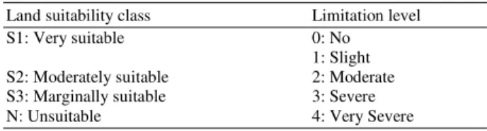
Table 3: Relationship between land suitability class and limitation level
Land suitability class Limitation level
S1: Very suitable 0: No
1: Slight
S2: Moderately suitable 2: Moderate
S3: Marginally suitable 3: Severe
N: Unsuitable 4: Very Severe
Applying a DSS for effectively Land Suitability evaluation and crop selection problem is not only desirable, but also important. The DSS provides the decision maker with effective mechanisms to better understand the decision problem and the implications of their decision behaviors to the organization by allowing them to interactively exchange information between the system and themselves (Mallach, 2000; Smith, 1992; Wei et al., 2007). Due to the diversity and complexity of the selection criteria, their inter-relationships and the volume of information, the DSS has to be efficient, effective and flexible for effectively solving the general selection problem. The DSS is designed to help the decision maker choose the appropriate crops in a flexible and user-friendly manner by allowing the decision maker to input values to express his/her requirements and to fully explore the relationships between the criteria, the alternatives, the methods available and the outcome of the selection process.
The DSS consists of three major subsystems, namely, (a) the dialogue subsystem, (b) the input management subsystem and (c) the knowledge management subsystem which is consistent with the general architecture of DSS. The dialogue subsystem serves to integrate various other subsystems as well as to be responsible for user-friendly communications between the DSS and the decision maker. The subsystem coordinates all functions or commands selected by the decision maker. The interface provides flexibility for customizing the system by the decision maker, the interface is designed so that the decision maker can create, modify or eliminate criteria, or even define which criteria he/she intends to inquire about. A decision maker utilizes the database through the dialogue subsystem for analyzing different alternatives using the knowledge management subsystem.
The input management subsystem organizes and manages all the inputs for solving the land suitability evaluation and crop selection problem. The type and the quantity of data inputs for solving the problem vary typically from one problem to another. The input data are entered into the system for processing and they can also be edited after they have been entered into the system. It should be noted that the system is flexible to allow new data types to be added to the system due to the possible addition of new methods in the DSS.
Table 4: Linguistic values of land characteristics Land characteristics Linguistic fuzzy words
Average Cold, somewhat cold, cool, medium, warm,
temperature somewhat hot, hot
Rainfall Very low, low, moderately low, moderate,
moderately high, high, very high Air humidity Very low, low, moderately low, moderate,
moderately high, high, very high
Slope Flat, undulating, rolling, hilly, mountainous
Coarse fragments Low, moderately low, moderately high, high
Soil depth Shallow, somewhat shallow, somewhat
deep, deep
Soil CEC Low, high
pH H2O Strongly acid, weakly acid, neutral, weakly
bases, strongly bases
Bases saturation Low, medium, high
Organic carbon Low, medium, high
Salinity Low, moderately low, moderately high, high
Alkalinity Low, moderately low, moderately high, high
Surface rock Low, moderately low, moderately high, high Folded drown of rock Low, moderately low, moderately high, high
Table 5: Limitation level and rating Average
temperature interval Land suitability Limitation level
<10.5 Unsuitable (N) Very severe
9.5-15.5 Marginally suitable (S3) Severe
14.5-18.5 Moderately suitable (S2) Moderate
17.5-25.5 Very suitable (S1) Slight
24.5-30.5 Moderately suitable (S2) Moderate
29.5-35.5 Marginally suitable (S3) Severe
>34.5 Unsuitable (N) Very severe
The knowledge management subsystem manages all the fuzzy methods available in the DSS. For the sake of describing the proposed DSS, fuzzy methods have been included in the proposed DSS for helping assist the decision maker select the most appropriate crop to be planted. The proposed DSS consists of four phases, including (a) identification of the decision maker’s requirements, (b) determination of membership functions of each criteria, (c) determination of performance rating of each of land limitation, (d) determination of performance rating of landscape and soil limitation, (e) evaluation of land suitability class and (f) selecting the appropriate crop.
cold
1, at 9.5 (at) 10.5 at, 9.5 at 10.5
0, otherwise
≤
µ = − < ≤
(1)
somewhat_cold
1, 10.5 at 14.5
at 9.5, 9.5 at 10.5 (at)
15.5 at, 14.5 at 15.5 0, otherwise
< ≤
− < ≤
µ =
− < ≤
(2)
cool
1, 15.5 at 17.5
at 14.5, 14.5 at 15.5 (at)
18.5 at, 17.5 at 18.5 0, otherwise
< ≤
− < ≤
µ =
− < ≤
(3)
medium
1, 18.5 at 24.5
at 17.5, 17.5 at 18.5 (at)
25.5 at, 24.5 at 25.5 0, otherwise
< ≤
− < ≤
µ =
− < ≤
(4)
cool
1, 15.5 at 17.5
at 14.5, 14.5 at 15.5 (at)
18.5 at, 17.5 at 18.5 0, otherwise
< ≤
− < ≤
µ =
− < ≤
(5)
somewhat_hot
1, 30.5 at 34.5
at 29.5, 29.5 at 30.5 (at)
35.5 at, 34.5 at 35.5 0, otherwise
< ≤
− < ≤
µ =
− < ≤
(6) hot
1, at 35.5 (at) at 34.5, 34.5 at 35.5
0, otherwise
>
µ = − < ≤
(7)
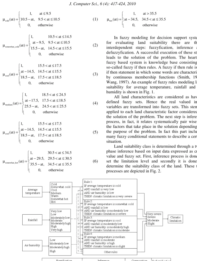
In fuzzy modeling for decision support systems for evaluating land suitability there are three interdependent steps: fuzzyfication, inference and defuzzyfication. A successful execution of these steps leads to the solution of the problem. The heart of fuzzy based system is knowledge base consisting of so-called fuzzy if then rules. A fuzzy if then rule is an if then statement in which some words are characterized by continuous membership functions (Smith, 1992; Wang, 1997). An example of fuzzy rules modeling land suitability for average temperature, rainfall and air humidity is shown in Fig. 1.
All land characteristics are considered as having defined fuzzy sets. Hence the real valued input variables are transformed into fuzzy sets. This stem is applied to each land characteristic factor considered in the solution of the problem. The next step is inference process, in fact, it relates systematically pair wise all the factors that take place in the solution depending on the purpose of the problem. In fact this part includes many fuzzy conditional statements to describe a certain situation.
Land suitability class is determined through a two-phase inference based on input data expressed as crisp value and fuzzy set. First, inference process is done to set the limitation level and secondly it is done to determine the suitability class of the land. These two processes are depicted in Fig. 2.
Fig. 2: Computing of limitations of fuzzy based DSS for land suitability evaluation
Fig. 3: Maximum composition of rules
In phase I inference, limitation level is concluded from inputted values of land characteristics. For land characteristics expressed as linguistic variables, i.e., characteristics related to climate, topography, physical soil (except soil texture), soil fertility, salinity and alkalinity and land preparation, limitation level is obtained from fuzzy inference. For illustration, a portion of the inference process to set these limitation levels based on input of crisp values, associated with climate, is illustrated in Fig. 3. Based on fuzzy inference, there are four phases in limitation level setting from crisp value input, namely fuzzyfication,
max composition method, which is composited from maximum points of all fuzzy sets generated from the results of min inference such as shown in the Fig. 7. The result of maximum composition then is used to calculate the deterministic value of a linguistic variable, the center average defuzzyfier is applied (Kiszka et al., 1985; Karray and Silva, 2004) as follows.
Supporse yk is a center of the kth fuzzy sets and wk
signifies the height, then, the center average defuzzyfier determines y* as:
M k
k k 1
M
k k 1
y w y*
w
=
=
=
∑
∑
(8)RESULTS
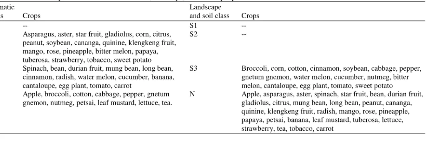
To demonstrate the applicability of the proposed DSS, a problem of evaluating land suitability and selecting crops, the input data are given either in crisp values or in fuzzy sets. As an example, given a set of crisp input data such as shown in Fig. 4, the fuzzy based DSS carried out four phases in determining the total land evaluation namely fuzzyfication, inference, composition and defuzzyfication described above. The max-min inference method is adopted in for the composition rules. This method is widely used in inference engine using fuzzy system due to its easiness in computation (Karray and Silva, 2004). The defuzzyfication method used in the study is center average defuzzyfier. It is easier to implement compared to the other two, center gravity and maximum defuzzyfier. The system results in the total land evaluation is shown in Fig. 5 and the total land evaluation is moderately suitable (S2) for crop of asparagus. Figure 6 shows the asparagus crop’s requirements are given by the system. The system receives fuzzy input as well, such as shown in Fig. 7.
The results of some testing data are summarized in Table 6. Table 6 indicates the land suitability class for each crop related to climate as well as landscape and soil.
Fig. 4: Example of crisp input data
Fig. 5: Example of output
Table 6: Land suitability class associated with climate, landscape, soil for crisp input data
Climatic Landscape
class Crops and soil class Crops
S1 -- S1 --
S2 Asparagus, aster, star fruit, gladiolus, corn, citrus, S2 --
peanut, soybean, cananga, quinine, klengkeng fruit, mango, rose, pineapple, bitter melon, papaya, tuberosa, strawberry, tobacco, sweet potato
S3 Spinach, bean, durian fruit, mung bean, long bean, S3 Broccoli, corn, cotton, cinnamon, soybean, cabbage, pepper,
cinnamon, radish, water melon, cucumber, banana, gnetum gnemon, water melon, cucumber, nutmeg, bitter
cantaloupe, egg plant, tomato, carrot melon, cantaloupe, egg plant, tomato, sweet potato
N Apple, broccoli, cotton, cabbage, pepper, gnetum N Apple, asparagus, aster, spinach, star fruit, bean, durian fruit, gnemon, nutmeg, petsai, leaf mustard, lettuce, tea. gladiolus, citrus, mung bean, long bean, peanut, cananga,
Fig. 6: Crop requirements
Fig. 7: Example of fuzzy input data
DISCUSSION
The developed system has been evaluated by the experts from Faculty of Agriculture both Gadjah Mada University and Soil and Agro climate Research Center Bogor, the result shows that it is capable of determining the land suitability class given the characteristics of the land, therefore, it can determine the appropriate crops to be cultivated. In addition, the system is also capable of determining the appropriate land characteristic for a given types of crops.
Fuzzy based model can represent and manipulate agriculture knowledge that is incomplete or vague and it can be used to determine land limitation rating. The rating value is used to determine limitation level of the land. At the similar limitation level for different types of crops, the rating value is used to determine what the most suitable crops to cultivate for the existing
condition of the land. The greater the rating value the more suitable crop for land of interest.
CONCLUSION
The developed DSS has the ability to determine land suitability class for agricultural purposes based on land characteristics being data inputted, i.e., climate, topography, wetness, physical soil, soil fertility, salinity and alkalinity, and land preparation.
The experimental results shows that land suitability classification based on the fuzzy model agrees with the classification made by experts in land suitability classification.
The fuzzy inference processes was used to define land limitation rating, which turn to determine limitation level of the corresponding characteristic. For similar limitation level, rating value was used to determine what crop production most suitable to the existing condition of the land. With greater rating limitation of a crop, the greater the suitability of the crop for the land of interest.
REFERENCES
FAO, 1981. A Framework for Land Evaluation. 2nd Edn., FAO, ISBN: 92-5-100111-1, pp: 7-21. Joerin, F., M. The’riault, and A. Musy, 2001. Using
GIS and outranking multicriteria analysis for land-usesuitability assessment. Int. J. Geogr. Inform. Sci., 15: 153- 174.
Karray, F.O. and C. Silva, 2004. Soft Computing and Intelligent Systems Design, Theory, Tools, and Applications.Pearson Education Limited,pp: 68. Kiszka, J.B., M.E. Kochanska and D.S. Sliwinska,
1985. The influence of some fuzzy implication operators on the accuracy of fuzzy model. Part II: Fuzzy Sets Syst., 15: 223-240.
Mallach, E.G., 2000. Decision Support and Data Warehouse Systems. McGraw-Hill, ISBN: 0-07-289981-6, pp: 148.
Ritung, S., F.A. Wahyunto and H. Hidayat, 2007. Guidelines Land Suitability Evaluation with a case map of Aceh Barat District. Indonesian Soil Research Institute and World Agroforestry Centre, ISBN: 979-3198-36-1, pp: 8-17.
Rossiter, D.G. and A.R. Van Wambeke, 1997. Automated Land Evaluation System. ALES Version 4.65 User’s Manual. Itc. http://www.itc.nl/~rossiter/Docs/ALES_V4.65_Ma nual.pdf
Wang, L., 1997. A Course in Fuzzy Systems and Control. Prentice-Hall, ISBN: 0-13-593005-7, pp: 105.
Wei, C.C., G.S. Liang and M.J. Wang, 2007. A comprehensive supply chain management project selection framework under fuzzy environment. Int. J. Project Manage., 25: 627-636.