2018
UNIVERSIDADE DE LISBOA
FACULDADE DE CIÊNCIAS
Estimating the Efficacy of Mass Rescue Operations in
Ocean Areas with Vehicle Routing Models and
Heuristics
Doutoramento em Estatística e Investigação Operacional
Especialidade de Otimização
Rui Pedro Gonçalves de Deus
Tese orientada pelo:
Prof. Doutor Luís Eduardo Neves Gouveia
2018
UNIVERSIDADE DE LISBOA
FACULDADE DE CIÊNCIAS
Estimating the Efficacy of Mass Rescue Operations in
Ocean Areas with Vehicle Routing Models and
Heuristics
Doutoramento em Estatística e
Investigação
Operacional
Especialidade de Otimização
Rui Pedro Gonçalves de Deus
Tese orientada pelo:
Prof. Doutor Luís Eduardo Neves Gouveia
Júri: Presidente:
•Doutora Maria Teresa dos Santos Hill de Agorreta de Alpuim, Professora Catedrática, Faculdade de Ciências da Universidade de Lisboa
Vogais:
•Doutor Stefan Voss, Professor , Hamburg Business School da Universität Hamburg (Alemanha) •Doutor José Fernando da Costa Oliveira, Professor Catedrático, Faculdade de Engenharia da
Universidade do Porto;
•Doutor João José Maia Martins, Chefe de Gabinete de Qualidade e Avaliação da Escola Naval, Marinha Portuguesa, na qualidade de individualidade de reconhecida competência na área científica;
•Doutor José Manuel Pinto Paixão, Professor Catedrático, Faculdade de Ciências da Universidade de Lisboa;
•Doutor Luís Eduardo Neves Gouveia, Professor Catedrático, Faculdade de Ciências da Universidade de Lisboa (orientador);
•Doutora Maria Eugénia Vasconcelos Captivo, Professora Catedrática, Faculdade de Ciências da Universidade de Lisboa.
Documento especialmente elaborado para a obtenção do grau de doutor
Este trabalho foi financiado pela Marinha Portuguesa ao abrigo do Plano de atividades de Formação no âmbito nacional (PAFN)
iv THIS PAGE INTENTIONALLY LEFT BLANK
v
Epigraph
“Basically because it’s a big problem for our members. The IMO
define a mass rescue operation (MRO) as being characterised by the need
for immediate response to large numbers of persons in distress such that
the capabilities normally available to the SAR authorities are inadequate,
which is an IMO way of saying it’s almost too big to handle. Well, it’s
certainly big and it’s certainly difficult and it’s certainly pretty scary but
we believe that properly prepared, it isn’t too big to handle and it’s that
preparation which is the key.”
David Jardine-Smith, Secretary, IMRF (answering
why MRO are such a big priority for the IMRF)
vi THIS PAGE INTENTIONALLY LEFT BLANK
vii
Abstract
Mass rescue operations (MRO) in maritime areas, particularly in ocean areas, are a major concern for the authorities responsible for conducting search and rescue (SAR) activities. A mass rescue operation can be defined as a search and rescue activity characterized by the need for immediate assistance to a large number of persons in distress, such that the capabilities normally available to search and rescue are inadequate. In this dissertation we deal with a mass rescue operation within ocean areas and we consider the problem of rescuing a set of survivors following a maritime incident (cruise ship, oil platform, ditched airplane) that are drifting in time. The recovery of survivors is performed by nearby ships and helicopters. We also consider the possibility of ships capable of refuelling helicopters while hovering which can extend the range to which survivors can be rescued. A linear binary integer formulation is presented along with an application that allows users to build instances of the problem. The formulation considers a discretization of time within a certain time step in order to assess the possibility of travelling along different locations. The problem considered in this work can be perceived as an extension of the generalized vehicle routing problem (GVRP) with a profit stance since we may not be able to recover all of the survivors. We also present a look ahead approach, based on the pilot method, to the problem along with some optimal results using state of the art Mixed-integer linear programming solvers.
Finally, the efficacy of the solution from the GVRP is estimated for a set of scenarios that combine incident severity, location, traffic density for nearby ships and SAR assets availability and location. Using traffic density maps and the estimated MRO efficacy, one can produce a combined vulnerability map to ascertain the quality of response to each scenario.
Key words: mass rescue operations, SAR system efficacy, vehicle routing problem, pilot method
viii THIS PAGE INTENTIONALLY LEFT BLANK
ix
Resumo
(Abstract in portuguese)
Uma operação de salvamento em larga escala caracteriza-se pela necessidade de prestar auxílio imediato a um elevado número de pessoas que, nesse momento, se encontram em risco de vida em circunstâncias em que os meios e capacidades ao nível do sistema de busca e salvamento não são os adequados para garantir uma resposta imediata. Este tipo de operação ocorre com uma frequência inferior, quando comparado com as típicas operações de busca e salvamento, no entanto, os incidentes que requerem estas operações acarretam consequências de elevado valor em termos de vidas humanas e prejuízos materiais. Operações desta natureza poderão envolver centenas ou mesmo milhares de pessoas que necessitam de socorro em ambientes por vezes longínquos e adversos à condição humana. Inundações, terramotos, ataques terroristas, acidentes em plataformas petrolíferas situadas em zonas costeiras ou a colisão de um navio de passageiros de grande porte são exemplos, que, pela sua magnitude, podem requerer o empenhamento de meios de salvamento necessários para realizar uma operação de salvamento em larga escala. A existência de planos de contingência e de uma capacidade de resposta eficaz constituem fatores-chave para evitar as consequências já referidas.
Do vasto leque de operações de salvamento em larga escala existente, o presente trabalho particulariza aquelas que ocorrem em ambiente marítimo, ou seja, no mar. Os incidentes que poderão requerer uma operação de salvamento marítimo em larga escala são múltiplos e apresentam diferentes características. Em geral, o denominador comum neste tipo de incidentes reside no facto de existir um número elevado de pessoas que precisam de ser socorridas sem que haja forma de fazer chegar meios de salvamento de forma imediata ao local do incidente e com a capacidade de salvamento necessária. Por exemplo, um acidente numa plataforma petrolífera, onde trabalham cerca de 100 pessoas, poderá constituir um incidente com um número elevado de vítimas mortais, caso não seja possível atuar de forma imediata. Neste tipo de plataformas, que, de uma forma geral, se situam em zonas costeiras, e por conseguinte, estão relativamente próximas de meios de socorro, aquando da chegada ao local do incidente dos primeiros meios de salvamento, os sobreviventes poderão encontrar-se já a flutuar na água, ou resguardados em jangadas ou embarcações de salvamento pertencentes à plataforma. As condições meteorológicas no local e o tempo que os sobreviventes permanecem na água após a ocorrência de um incidente constituem fatores críticos no planeamento de uma operação desta natureza. As condições meteorológicas são
x um fator crítico, quer para a sobrevivência dos sinistrados após o incidente, quer para a sua recuperação. Se as condições atmosféricas e oceanográficas forem adversas, a recuperação dos sobreviventes que se encontram na água poderá não ser exequível ou demorar mais tempo que o normal. O tempo que os sobreviventes passam na água ou em jangadas até que sejam recuperados por meios de salvamento poderá variar entre poucos minutos e várias horas. No caso de o incidente ocorrer em águas oceânicas, tanto os sobreviventes na água como aqueles que se encontram resguardados em jangadas ou embarcações de salvamento irão estar sujeitos ao efeito da deriva marítima. Em águas oceânicas, o movimento de objetos na superfície da água é influenciado principalmente por duas componentes da deriva marítima: o abatimento e as correntes de vento. Caso a chegada dos meios de busca e salvamento ao local do incidente seja demorada, a ação destas forças sobre os sobreviventes, jangadas e embarcações irá dispersá-los e tornar a sua recuperação mais morosa e difícil.
Este tipo de operações viu a sua importância ser reconhecida com a realização de cruzeiros turísticos a zonas do Ártico. Estas zonas não possuem infraestruturas de salvamento nas suas proximidades com capacidade adequada para responder a um possível incidente que requeira uma operação de salvamento em larga escala. Este tipo de atividade suscitou a preocupação do Comité de Segurança Marítima da International Maritime Organization (IMO) que promoveu a discussão do risco associado a navios de cruzeiro a operar em áreas remotas entre os seus Estados membros e organizações internacionais com assento neste comité. Fruto desta discussão, foi reconhecido que o conceito de “áreas remotas” não se encontra circunscrito a zonas longíquas como o Ártico e que estas áreas poderão existir nas regiões de busca e salvamento marítimo dos Estados costeiros em zonas bem mais próximas de infraestruturas de salvamento do que se pensava até então. Para além desta situação, a ameaça de ataques terroristas a navios de cruzeiro contribuiu também para aumentar a preocupação das entidades governamentais dos Estados costeiros em relação às operações de salvamento em larga escala.
Neste trabalho pretende-se estimar a eficácia de uma operação de salvamento em larga escala através de modelos de otimização combinatória para problemas de roteamento de veículos. Para este efeito, é formulado o problema de salvamento marítimo em larga escala, designado por problema MMRO, que consiste numa variante do problema de roteamento de veículos generalizado onde se pretende visitar um conjunto de clientes que correspondem a objetos SAR (pessoas na água, jangadas salva-vidas e embarcações à deriva) através de um conjunto de veículos heterogéneos que se deslocam com diferentes velocidades. Este problema tem a particularidade de considerar a deriva dos objetos ao longo do tempo por estes estarem sujeitos ao efeito da deriva marítima. Para além da modelação do problema
xi através de modelos combinatórios, pretende-se avaliar de que forma o conhecimento dos tempos de sobrevivência por parte do sistema SAR tem impacto na eficácia das operações de salvamento. Este tipo de informação é utilizado num critério para prioritizar os objectos a serem recuperados por um determinado veículo. Para este efeito, são testados diferentes variantes de heurísticas para o problema MMRO, que incorporam diferentes critérios de prioridade. Uma das questões que se procura responder prende-se com o conhecimento do estado de saúde das pessoas que estão na água ou em jangadas salva-vidas por parte de quem está a a coordenar os veículos, quer estes sejam aéreos ou navais, e se essa informação pode ser usada para uma coordenação das ações de recuperação de sobreviventes mais eficiente. Nos procedimentos de recuperação standard, um veículo utiliza o critério da distância para decidir qual o objecto que irá recuperar. No caso de existir mais do que um veículo a operar, então o critério é baseado no tempo de viagem até chegar ao objecto. Estas variantes são incorporadas num procedimento de look ahead, designado por método piloto, de forma a resolver instâncias do problema MMRO que os métodos exactos não são capazes de resolver.
De forma a permitir a criação de instâncias que representem um incidente envolvendo vários objetos SAR, é desenvolvido um protótipo em MATLAB que disponibiliza diversas funcionalidades de um sistema de informação geográfico para colocação e manuseamento de objetos num mapa e cálculo de distâncias. Este protótipo permite ainda ao utilizador selecionar vários tipos de heurísticas, entre as quais diversas variantes do método piloto e analisar a sua eficácia e outras características associadas à solução (tempo médio que cada objeto permaneceu na água até ser recuperado, número de milhas percorridas por cada veículo, etc). Este protótipo afigura-se como um instrumento de estudo para avaliar a resposta de um sistema SAR a um incidente localizado numa área oceânica e permite efetuar uma análise de sensibilidade em função da disponibilidade de meios de salvamento.
xii THIS PAGE INTENTIONALLY LEFT BLANK
xiii
Agradecimentos
(Acknowledgments in portuguese)
Quero prestar um sentido agradecimento ao meu orientador, Professor Luís Gouveia, em primeiro lugar, por me ter aceite na qualidade de aluno de doutoramento, com a condição de que o problema a estudar nesta tese fosse oriundo do meio naval com aplicação e utilidade para a Marinha Portuguesa. Julgo que, por este motivo, o desafio inerente a este trabalho, tanto para o aluno como para o orientador, foi maior, mas mais gratificante. E em segundo lugar, pelo previlégio da sua orientação ao longo destes últimos anos, que muito prezo.
O presente trabalho beneficiou da experiência de muitos militares da Marinha Portuguesa e da Esquadra 751 - “Pumas” da Força Aérea Portuguesa, com quem tive oportunidade de aprender e que muito contribuiram para o meu conhecimento sobre a função de busca e salvamento marítimo que é assegurada pela Marinha Portuguesa 24 horas por dia, 365 dias por ano em colaboração com a Força Aérea Portuguesa. Não poderia deixar de expressar o meu agradecimento aos Comandantes Anjinho Mourinha, Correia Guerreiro, Madaleno Galocha, Silva Lampreia, Dias Marques, Santos Serafim, Jacinto Canto, entre outros, com quem tive e tenho a sorte de trabalhar.
Quero também agradecer ao Comandante João Maia Martins pela disponibilidade e pelos conselhos dados ao longo da elaboração deste trabalho, pois sem estar nomeado formalmente como tal, foi o tutor da Marinha neste período da minha formação. A sua larga experiência na área operacional e, em particular, na busca e salvamento muito contribuiram para a definição do problema abordado nesta tese.
Gostaria de deixar uma palavra de apreço ao Comodoro Alves Francisco pelo seu apoio, motivação e pelo nível de exigência que sempre incutiu aos seus subordinados e à minha pessoa. Somos sempre capazes de fazer mais e melhor.
O presente trabalho foi financiado pela Marinha Portuguesa através do Plano de Atividades de Formação no âmbito nacional (PAFN), tendo sido realizado fora das horas de serviço.
xiv Agradeço também aos meus pais, em particular à minha mãe, pelo incentivo e ânimo constante ao longo destes anos.
For fim, quero agradecer à Patrícia, que foi a pessoa mais sacrificada neste período e que foi sempre o meu porto de abrigo. Sem ela, duvido que esta tese tivesse um fim!
Este trabalho é para ti, Pedro! Que te sirva de exemplo e de motivação para os desafios que irás abraçar!
xv
Contents
Abstract ... vii
Resumo ... ix
Agradecimentos ... xiii
Contents ... xv
List of Figures ... xix
List of Tables ... xxiii
Abbreviations and Acronyms ... xxv
Table of Notation ... xxix
1
Introduction ... 3
1.1 Problem description ... 3
1.1.1 Maritime Mass Rescue Operation problem in terms of graphs ... 5
1.1.2 Example of MMRO problem and solution in graph... 6
1.2 Goals of the dissertation ... 8
1.2.1 Summary of goals ... 9
1.3 Scope of the dissertation ... 10
1.4 Structure of the dissertation ... 12
2
Literature Review ... 17
2.1 Maritime mass rescue operations review ... 17
2.1.1 Examples of maritime mass rescue operations ... 19
2.1.2 Legal obligations placed upon shipping for rendering assistance to persons in distress ... 24
2.1.3 Mass rescue operation doctrine ... 27
2.1.4 Portuguese Maritime SAR System ... 34
2.1.5 Risks and threats for cruise ships ... 42
2.2 Related vehicle routing models and variants ... 45
xvi
2.2.2 Layered graphs ... 53
2.2.3 Reduction of the MMRO problem to various routing problems ... 58
2.3 Look-ahead methods for combinatorial optimization problems ... 60
2.3.1 Pilot method for combinatorial optimization problems ... 62
2.3.2 Design options within the pilot method ... 67
2.4 Summary ... 68
3
Maritime Mass Rescue Operation Problem: Vehicle Flow
Formulation and Heuristics ... 73
3.1 Modelling the MMRO problem ... 73
3.1.1 A motivating example ... 74
3.1.2 Node definition ... 76
3.1.3 Arc definition ... 81
3.1.4 Algorithm for building a MMRO problem instance ... 86
3.2 Vehicle flow formulation ... 89
3.3 Constructive heuristics ... 92
3.3.1 Criteria based on merit function for choosing a feasible vehicle/survivor assignment ... 94
3.3.2 Simple sequential constructive heuristic ... 95
3.3.3 Greedy sequential constructive heuristic ... 96
3.3.4 Variants obtained by combining different criteria ... 98
3.4 Pilot method ... 99
3.4.1 Enumeration of all possible solutions with the pilot method ... 106
3.5 Prototype for building MMRO instances ... 107
3.5.1 Building an instance ... 109
3.5.2 Solving the problem with heuristics ... 116
3.5.3 Efficacy of the solution ... 118
3.5.4 Comparison of pilot method variations ... 121
3.6 Computational experiments ... 123
3.6.1 Experimental data sets ... 123
3.6.2 Pilot method variants ... 127
3.6.3 Results ... 128
3.7 Summary ... 142
xvii
4.1 Areas remote from SAR facilities ... 148
4.2 The scenario: incident during transit ... 152
4.2.1 Setting the MMRO problem data ... 155
4.2.2 MMRO Efficacy ... 157
4.3 Procedure to characterize areas remote from SAR facilities ... 160
4.4 Summary ... 166
5
Results and Discussion ... 171
5.1 Heuristics performance and the availability of survival times ... 171
5.2 Addressing the refuelling issue heuristically ... 174
5.2.1 MMRO instances with refuelling ship ... 176
5.2.2 Vehicle/survivor assignments with refuelling ... 179
5.3 MMRO model advantages and limitations ... 182
5.3.1 Advantages ... 182
5.3.2 Limitations ... 183
5.4 Summary ... 185
6
Conclusion and Future Work ... 189
6.1 Summary and conclusions ... 189
6.2 Future work ... 191
References ... 195
Annex A - List of SAR Objects and leeway values ... 223
Annex B - Criteria for determining “areas remote from SAR
facilities” ... 225
Annex C - Vulnerability maps for cruise ships ... 227
Appendix A - Time performance for partial pilot method
variants ... 231
xviii THIS PAGE INTENTIONALLY LEFT BLANK
xix
List of Figures
Figure 1. MMRO solution in the corresponding graph ... 7
Figure 2. The ro-ro passenger ferry ESTONIA (left) and its route with site of accident (right) ... 20
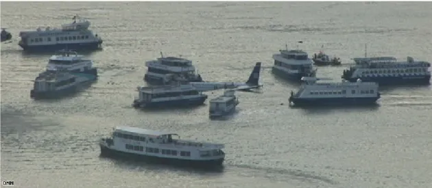
Figure 3. Flight 1549 aircraft surrounded by ferries and boats after evacuation ... 21
Figure 4. Costa Concordia during evacuation (left) and map with the route made near Giglio Island (right) ... 23
Figure 5. SAR stages and emergency phases during SAR incident ... 29
Figure 6. Organization chart of the Portuguese Maritime SAR System ... 35
Figure 7. Portuguese Search and Rescue Regions (SRRs) ... 36
Figure 8. Naval SRU types employed by the Portuguese Navy in the SRRs. From left to right: Viana do Castelo class ocean patrol vessel, Baptista de Andrade class corvettes and Tejo class offshore patrol vessel ... 37
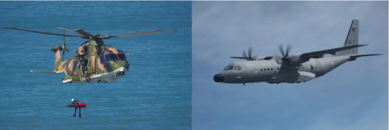
Figure 9. Aerial SAR units used by FAP. From left to rigth: EH-101 Merlin and EADS C-295M ... 38
Figure 10. Oversee’s maritime picture showing positions of vessels equipped with AIS and MONICAP ... 40
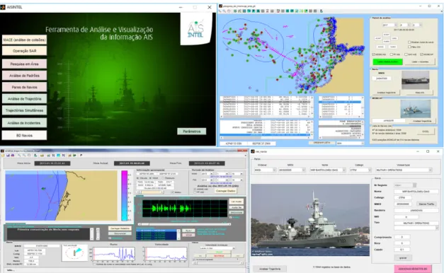
Figure 11. AISINTEL prototype for AIS and VMS data analysis ... 41
Figure 12. A feasible solution to the Generalized Vehicle Routing Problem ... 48
Figure 13. Illustrative example of MMRO solution in original graph ... 54
Figure 14. Layered graph representation of the MMRO instance ... 55
Figure 15. Layered graph with arcs associated to feasible movements of vehicles that move at the same speed ... 56
Figure 16. Reduction of the MMRO model to various routing problems ... 59
Figure 17. Search graph in iteration 1 of the pilot method for a two-level depth parameter with breadth vector (2,3) ... 65
Figure 18. Example of small instance of the MMRO problem ... 75
Figure 19. Node representation in layered graph for the MMRO problem ... 77
Figure 20. Vector plots for surface drift forces and datum sequence for drifting object ... 79
Figure 21. Distance matrixes D, Dℎ and D𝑛𝑛𝑛𝑛 from left to right. ... 85
Figure 22. Diagram of objects and nodes in a MMRO problem ... 88
xx Figure 24. Assignment tree for enumerating sequences of two successive feasible
assignments ... 102
Figure 25. Enumeration of solutions for MMRO problem with 2 vehicles and 3 objects to recover ... 106
Figure 26. Prototype main interface to build and analyse MMRO problems ... 108
Figure 27. Initial location of distress survivors that require recovery ... 110
Figure 28. Survivors drift along 3 hours within water ... 111
Figure 29. Node table. Relates node index with location, time, survivability, MMRO object type ... 112
Figure 30. Helicopter’s distance matrix ... 113
Figure 31. Nearby ship distance matrix ... 113
Figure 32. Nodes of Layered Graph within an Object index - time stamp axis ... 114
Figure 33. Arcs table. Relates arc indexes with nodes, vehicles, cost and distance ... 115
Figure 34. MMRO solution obtained by HC1d ... 117
Figure 35. Arc description within solution ... 117
Figure 36. HC1d solution in layered graph ... 118
Figure 37. Performance of the MMRO solution ... 119
Figure 38. Interface to compare two pilot solutions ... 122
Figure 39. Survivor’s and rescue unit’s location for experimental MMRO instances ... 124
Figure 40. Performance for constructive heuristics and full pilot methods variants with one and two levels ... 136
Figure 41. Average performance for partial pilot method variants with one level... 136
Figure 42. Average performance for partial pilot method variants with two levels ... 137
Figure 43. Performance of full pilot method variants and constructive heuristics for random costs sets... 139
Figure 44. Average performance for full pilot method variants with time limits for real set v3n80 ... 140
Figure 45. Average performance of full pilot method variants with time limit for set v4n80 ... 141
Figure 46. Average performance of full pilot method variants with time limit for set v5n80 ... 141
Figure 47. EEZ and SAR areas of Portugal ... 147
Figure 48. Passenger ship density (period: 2016, mesh: 0.1 𝑁𝑁𝑁𝑁2). Source: PO Navy, Naval Command ... 150
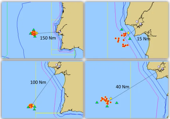
Figure 49. Areas that cover major cruise ship routes that make port calls in Madeira Island ... 151
xxi Figure 50. Visions of the Sea transit on April 27th 2016 inside Madeira-Gibraltar area at
02:58:37 ... 152
Figure 51.Visions of the Sea transit on April 27th 2016 inside Madeira-Gibraltar area at 03:29:26 ... 153
Figure 52. MMRO Prototype with incident data and rescue solution ... 156
Figure 53. SAR efficacy and vehicle load after rescue operation - variant 1B ... 158
Figure 54. SAR Efficacy and vehicle load after rescue operation - variant 2B ... 159
Figure 55. SAR Efficacy and vehicle load after rescue operation - variant 3B ... 159
Figure 56. Passenger ship AIS density. Period: 2016. Mesh size: 5 𝑁𝑁𝑁𝑁2... 161
Figure 57. Vulnerability index (4.1) over passenger ship density. Mesh size: 5 𝑁𝑁𝑁𝑁2 ... 162
Figure 58. Vessel data: nearest airbase, closest opportunity ship and vulnerability index ... 166
Figure 59. Survival time for people in the water wearing normal clothing ... 171
Figure 60. The "Barnett" curve: Time of life expectancy with no exposure suit ... 172
Figure 61. A Seaking Helicopter is refuelled in-flight from the deck of RFA Argus ... 175
Figure 62. Solution for MMRO instance with vessel capable of refuelling ... 177
Figure 63. MMRO graph model with the optimal solution. Object 3 is the vessel with refuelling capability ... 178
Figure 64. Unpractible MMRO solution with vessel capable of refuelling ... 179
Figure 65. Procedure to check helicopter/survivor assignment feasibility with HIFR .... 181
Figure 66. Polygon: “Madeira centro”. Mesh: 1 𝑁𝑁𝑁𝑁2 ... 227
Figure 67. Polygon: “Madeira sul”. Mesh: 2 𝑁𝑁𝑁𝑁2 ... 228
Figure 68. Polygon: “Madeira este”. Mesh: 1.5 𝑁𝑁𝑁𝑁2 ... 228
Figure 69. Polygon: “Comando de Zona Marítimo do Centro” . Mesh: 0.75 𝑁𝑁𝑁𝑁2 ... 229
xxii THIS PAGE INTENTIONALLY LEFT BLANK
xxiii
List of Tables
Table 1. Size of inputs for different instances of the MMRO problem. ... 91 Table 2. Possible variations for the constructive heuristics ... 98 Table 3. Location of PIW in MMRO instance. ... 111 Table 4. Instances description with 3 vehicles. ... 125 Table 5. Instances description with 4 vehicles. ... 126 Table 6. Instances description with 5 vehicles. ... 126 Table 7. Pilot method variants enumeration ... 128 Table 8. Stand-alone results for constructive heuristics ... 129 Table 9. Performance of full pilot methods variations with one level ... 130 Table 10. Time performance for stand-alone constructive heuristics variations ... 130 Table 11. Time performance for full pilot method variations with one level ... 131 Table 12. Performance of full pilot methods variations with two levels ... 131 Table 13. Time performance for full pilot method variations with two levels ... 132 Table 14. Performance of partial pilot method variations with one level and distance criteria ... 132 Table 15. Performance of partial pilot method variations with one level and ETA criteria ... 133 Table 16. Performance of partial pilot method variations with one level and profit criteria ... 133 Table 17. Performance of partial pilot method with two levels and distance criteria .... 134 Table 18. Performance of partial pilot method with two levels and ETA criteria ... 134 Table 19. Performance of partial pilot method variations with two levels and profit criteria ... 135 Table 20. Time performance of Branch-and-bound algorithm within MATLAB intlinprog function ... 135 Table 21. Stand-alone results for constructive heuristics ... 138 Table 22. Performance of full pilot methods variations with one level ... 138 Table 23. Performance of full pilot method variations with one levels and 20 minutes time limit ... 139 Table 24. Performance of full pilot method variations with two levels and 20 minutes time limit ... 140 Table 25. SAR efficacy for MRO scenario variants ... 157 Table 26. Leeway parameters of obtaining leeway speed. ... 223
xxiv Table 27. Time performance of partial pilot method variations with one level and distance criteria ... 231 Table 28. Time performance of partial pilot method variations with one level and ETA criteria ... 231 Table 29. Time performance of partial pilot method with one level and profit criteria . 232 Table 30. Time performance of partial pilot method with two levels and distance criteria ... 232 Table 31. Time performance of partial pilot method with two levels and ETA criteria 232 Table 32. Time performance of partial pilot method with two levels and profit criteria 233
xxv
Abbreviations and Acronyms
A
AIS Automatic Identification System
AISINTEL Ferramenta de análise e visualização de dados AIS e MONICAP AGV Automated Guided Vehicles
AM Ante merīdiem (before midday)
ASWORG Antisubmarine Warfare Operations Research Group
B
BSM Busca e Salvamento Marítimo (search and rescue in portuguese) BWTSP Black-and-white traveling salesman problem
C
C2 Command and Control
CINAV Portuguese Naval Research Center CLIA Cruise Lines International Association CODU Centro de Orientação de Doentes Urgentes COI Contact Of Interest
COMAR Centro de Operações Marítimas
COMNAV Naval Command
COMSAR Sub-Committee on Radio Communications and Search and Rescue ConFL Connected Facility Location problem
CPU Central Processing Unit CSW Critical Software
CTSP Capacitated traveling salesman problem CVRP Capacitated vehicle routing problem
CGWRP Capacitated General Windy Routing Problem
D
DAGI Direção de Análise e Gestão da Informação
DGRM Direção Geral de Recursos Naturais, Segurança e Serviços Marítimos DOM Disaster Operations Management
DSS Decision support system
DTG Date Time Group
E
EADS European Aeronautic Defence and Space Company EEZ Economic Exclusive Zone
EFF Efficacy
EMSA European Maritime Safety Agency
EPIRB Emergency Position-Indicating Radio Beacon ETA Expected Time Arrival
xxvi F
FIR Flight Information Region
G
GAMA Accident Investigation Bureau Maritime and Aeronautical Meteorology Authority GIS Geographic information system
GDH Grupo Data Hora
GmTSP Generalized multiple traveling salesman problem GPS Global Positioning System
GRIB GRIdded Binary
GTD Global terrorism database
GTSP Generalized traveling salesman problem GVRP Generalized vehicle routing problem
GVRPTW Generalized vehicle routing problem with time windows
H
HIFR Helicopter in-flight refuelling
HMSTP hop-constrained minimum spanning tree problem
I
IALA International Association of Marine Aids to Navigation and Lighthouse Authorities IAMSAR International Aeronautical Maritime Search and Rescue manual IED Improvised explosive device
ICAO International Civil Aviation Organization ILP Integer linear programming
IMO International Maritime Organization IMRF International Maritime Rescue Federation IT Information Technology
ITU International Telecommunication Union
K
Kts Knots (nautical miles per hour)
L
LLA Lives lost after notification LLB Lives lost before notification LNS Large neighbourhood search
LS Lives saved
LUF Lives unaccounted for
LW Leeway
xxvii MATLAB MATrix LABoratory
MCARPTC Mixed capacitated routing problem with turn constraints MEDEVAC Medical evacuation
MDGVRP Multiple depot generalized vehicle routing problem MDOVRP Multi-Depot Open Vehicle Routing Problem
MDT MMRO Design Tool
MDTSP Multiple-depot Traveling Salesman Problem MDVRP Multiple-depot Vehicle Routing Problem MIT Italian Ministry of Infrastructure
MMRO Maritime Mass Rescue Operation MMSI Maritime Mobile Service Identity MoD Ministry of Defense
MONICAP Monitorização Contínua das Atividades da Pesca MRCC Maritime Rescue Co-ordinator Centre
MRO Mass Rescue Operation
MROSS Mass Rescue Operations Scoping Study MRSC Maritime Rescue Sub-Center
MSP Maritime spatial planning
N
Nm Nautical Miles
NNH Nearest Neighbour Heuristic
NTSB National Transportation Safety Board
O
OP Orienteering problem OPV Ocean Patrol Vessel OSC On-scene co-ordinator
P
PCTSP Prize Collecting Traveling Salesman Problem PCVRP Prize Collecting Vehicle Routing Problem PIW Person in the water
PL Value of Property Lost
PLP Value of Property Loss Prevented PTP Profitable tour problem
PUF Property unaccounted for
R
RADAR RAdio Detection And Ranging RCC Rescue Coordinator Centre RDC Research & Development Center RSC Rescue Sub-centre
xxviii S
SARP Selective Assessment Routing Problem SMC SAR mission coordinator
SOG Speed over ground
SOLAS Convention for Safety of Life at Sea SRR Search and Rescue Region
SRRLX Search and Rescue Region – Área de Lisboa SRRST Search and Rescue Region – Área de Santa Maria SRU Search and Rescue Unit
STPRBH Steiner tree problem with revenues, budget and hop-constraints
T
TC Tidal current
TDTSP Time-dependent travelling salesman problem TOP Team orienteering problem
TSP Traveling salesman problem
V
VHF Very High Frequency VMS Vessel Monitoring System VTS Vessel Tracking System
U
UAV Unmanned aerial vehicle
UN United Nations
UNCLOS United Nations Convention on the Law of the Sea USCG United States Coast Guard
UTC Coordinated Universal Time
W
WC Wind current
xxix
Table of Notation
Symbol
Page
Description
𝐺𝐺 = (𝑉𝑉, 𝐴𝐴) p. 5 Directed graph where 𝑉𝑉 is the set of nodes and 𝐴𝐴 = ��𝑣𝑣𝑖𝑖, 𝑣𝑣𝑗𝑗�: 𝑣𝑣𝑖𝑖, 𝑣𝑣𝑗𝑗∈ 𝑉𝑉, 𝑖𝑖 ≠ 𝑗𝑗� is the set of arcs
𝑐𝑐𝑖𝑖𝑗𝑗 p. 5 Nonnegative profit associated with each arc �𝑣𝑣𝑖𝑖, 𝑣𝑣𝑗𝑗�
𝑄𝑄𝑘𝑘 p. 5 Capacity of vehicle 𝑘𝑘
𝐴𝐴𝑘𝑘 p. 5 Subset of feasible arcs used by vehicle 𝑘𝑘
𝐿𝐿𝑘𝑘 p. 5 Limit in the distance that vehicle 𝑘𝑘 can travel
𝑆𝑆𝐷𝐷(𝑘𝑘) p. 5 Set of possible starting nodes (starting depot) for vehicle 𝑘𝑘
𝐸𝐸𝐷𝐷(𝑘𝑘) p. 6 Set of possible ending nodes (ending depot) for vehicle 𝑘𝑘
𝑆𝑆𝑖𝑖 p. 6 Set of nodes associated to costumer 𝑖𝑖 (each costumer is
represented by a cluster of nodes)
𝑑𝑑𝑖𝑖 p. 6 Demand of costumer 𝑖𝑖 (all nodes in the cluster 𝑆𝑆𝑖𝑖 have the
same demand 𝑑𝑑𝑖𝑖)
𝑀𝑀 p. 62 Partial solution (also called “master solution”) within the pilot method
Tmax p. 63 Maximum time available used as a stop criteria within the pilot method
ℍ p. 62 Pilot heuristic or subheuristic used within the pilot method to obtain a fully grown solution from a partial solution 𝑐𝑐𝑁𝑁𝑖𝑖𝑐𝑐 p. 63 Best known cost of fully grown solutions within the pilot
method
Γ p. 66 Set of sequences of elements that can be included into the master solution within the pilot method
𝜉𝜉 p. 66 Sequence of elements that can be included into the master solution within the pilot method
𝐹𝐹 p. 77 Set of facilities for helicopters (airbases) 𝑁𝑁 p. 77 Set of initial location of nearby ships
𝑀𝑀 p. 77 Set of meeting locations used to transfer survivors and are use as the finish depot for nearby ships
xxx 𝑡𝑡0 p. 78 Initial instant of the incident which is also the time the
MRCC receives the alert
𝜏𝜏𝑡𝑡0 p. 78 Geographic location of the incident specified in latitude and
longitude degrees at time 𝑡𝑡0 (it is also refered as datum)
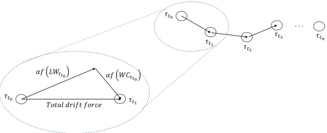
𝐿𝐿𝐿𝐿𝜏𝜏𝑡𝑡𝑖𝑖 p. 78 Local wind on datum 𝜏𝜏𝑡𝑡𝑖𝑖. It comprises the wind direction
and speed on datum 𝜏𝜏𝑡𝑡𝑖𝑖
𝐿𝐿𝐿𝐿𝑑𝑑𝑖𝑖𝑑𝑑 p. 78 Direction from where the wind blows at datum 𝜏𝜏𝑡𝑡𝑖𝑖
𝐿𝐿𝐿𝐿𝑛𝑛𝑠𝑠𝑑𝑑 p. 78 Speed in knotsof local wind at datum 𝜏𝜏𝑡𝑡𝑖𝑖
𝑓𝑓 �𝐿𝐿𝐿𝐿𝜏𝜏𝑡𝑡𝑖𝑖� p. 78 Object’s leeway caused by the wind blowing on the exposed
surface of the object 𝐿𝐿𝑊𝑊𝜏𝜏𝑡𝑡𝑖𝑖 p. 78 Wind current on datum 𝜏𝜏𝑡𝑡𝑖𝑖
𝑇𝑇𝑀𝑀 p. 78 Mission period, or mission time window, which can also be
stated as 𝑇𝑇𝑀𝑀= 𝑡𝑡𝑛𝑛− 𝑡𝑡0
𝑈𝑈 p. 79 Random variable with uniform distribution
𝛾𝛾 p. 79 Random variable that represents the variations on the leeway speed
𝛼𝛼 p. 79, p. 80 Time step parameter that scales the total drift force applied to an object located on datum 𝜏𝜏𝑡𝑡𝑖𝑖
𝑓𝑓(𝑖𝑖, 𝑡𝑡) p. 81 Node index of object 𝑖𝑖 at the time index 𝑡𝑡
𝑔𝑔(𝑖𝑖) p. 81 Cluster index of node 𝑖𝑖 (clusters are associated to the objects in the MMRO problem)
𝑡𝑡°(𝑖𝑖) p. 82 Time instant (date format) associated to the departure time
from datum 𝑖𝑖
𝑡𝑡𝑡𝑡(𝑖𝑖, 𝑗𝑗) p. 82 Travel time between datum 𝑖𝑖 and datum 𝑗𝑗 and it is obtained dividing the distance between 𝑖𝑖 and 𝑗𝑗 by the cruise speed of the helicopter or nearby ship
𝑡𝑡𝑟𝑟𝑟𝑟_𝑡𝑡𝑖𝑖𝑁𝑁𝑟𝑟 p. 82 Rescue time required by the vehicle to recover the survivor
𝐴𝐴𝐹𝐹,𝑅𝑅ℎ p. 82 Set of arcs associated to helicopters from depots to nodes
representating the location of a replenishment ship
𝐴𝐴𝐹𝐹,𝑆𝑆ℎ p. 83 Set of arcs associated to helicopters from depots to nodes
representing a datum of a survivor or raft
𝐴𝐴𝑅𝑅,𝐹𝐹ℎ p. 83 Set of arcs associated to helicopters from the location of
replenishment ship to a node representing a depot
𝐴𝐴𝑅𝑅,𝑆𝑆ℎ p. 83 Set of arcs associated to helicopters from the location of
replenishment ship to a node representing a datum of a survivor or raft
xxxi
𝐴𝐴𝑆𝑆,𝐹𝐹ℎ p. 83 Set of arcs associated to helicopters from the datum of a
survivor or raft to a depot
𝐴𝐴𝑆𝑆,𝑅𝑅ℎ p. 83 Set of arcs associated to helicopters from the datum of a
survivor or raft to the location of replenishment ship
𝐴𝐴𝑆𝑆,𝑆𝑆ℎ p. 83 Set of arcs associated to helicopters between survivor or raft
datum
𝐴𝐴𝑁𝑁,𝑆𝑆𝑛𝑛𝑛𝑛 p. 83 Arcs from the nearby ship initial location to the datum of a
survivor or raft
𝐴𝐴𝑆𝑆,𝑀𝑀𝑛𝑛𝑛𝑛 p. 83 Arcs associated to nearby ships from the datum of a
survivor or raft to a meeting location
𝐴𝐴𝑆𝑆,𝑆𝑆𝑛𝑛𝑛𝑛 p. 83 Arcs associated to nearby ships between survivor or raft
datum
𝐷𝐷ℎ p. 84 Distance matrix associated to helicopters between
time-index nodes
𝐷𝐷𝑛𝑛𝑛𝑛 p. 84 Distance matrix associated to nearby ships between
time-index nodes
𝑡𝑡𝑟𝑟𝑓𝑓_𝑡𝑡𝑖𝑖𝑁𝑁𝑟𝑟 p. 86 Time required to refuel an helicopter from a replenishment ships
𝑣𝑣𝑟𝑟𝑘𝑘 p. 88 Line vector with the indexes of the objects (cluster indexes) associated to a solution or partial solution for the MMRO problem
𝑣𝑣𝑟𝑟𝑟𝑟 p. 88 Line vector with the indexes of the nodes (of the layered graph) associated to a solution or partial solution for the MMRO problem
𝑥𝑥𝑖𝑖𝑗𝑗𝑘𝑘𝑠𝑠𝑘𝑘 p. 89 Decision variable that indicate whether helicopter 𝑘𝑘 travels
from node (𝑖𝑖, 𝑝𝑝) to node (𝑗𝑗, 𝑞𝑞), 𝑥𝑥𝑖𝑖𝑗𝑗𝑘𝑘𝑠𝑠𝑘𝑘 = 1 or not, 𝑥𝑥
𝑖𝑖𝑗𝑗𝑘𝑘𝑠𝑠𝑘𝑘 = 0
(the indices 𝑖𝑖 and 𝑗𝑗 refer to the problem objects and the indices 𝑝𝑝 and 𝑞𝑞 refer to time stamps)
𝑦𝑦𝑖𝑖𝑗𝑗𝑙𝑙𝑠𝑠𝑘𝑘 p. 89 Decision variable that indicate whether nearby ship 𝑙𝑙 travels
from node (𝑖𝑖, 𝑝𝑝) to node (𝑗𝑗, 𝑞𝑞), 𝑦𝑦𝑖𝑖𝑗𝑗𝑙𝑙𝑠𝑠𝑘𝑘 = 1 or not,
𝑦𝑦𝑖𝑖𝑗𝑗𝑙𝑙𝑠𝑠𝑘𝑘 = 0 (the indices 𝑖𝑖 and 𝑗𝑗 refer to the problem objects
and the indices 𝑝𝑝 and 𝑞𝑞 refer to time stamps)
𝑑𝑑𝑖𝑖𝑗𝑗𝑘𝑘𝑠𝑠𝑘𝑘 p. 90 Distance between node (𝑖𝑖, 𝑝𝑝) to node (𝑗𝑗, 𝑞𝑞) (the indices 𝑖𝑖
and 𝑗𝑗 refer to the problem objects and the indices 𝑝𝑝 and 𝑞𝑞 refer to time stamps)
𝑡𝑡𝑖𝑖𝑗𝑗𝑠𝑠𝑘𝑘 p. 90 Distance in nautical miles gained by refuelling at node (𝑖𝑖, 𝑝𝑝) 𝐴𝐴𝐴𝐴𝑡𝑡𝑘𝑘 p. 90 Autonomy of helicopters in nautical miles
xxxii
𝐴𝐴𝑖𝑖 p. 90 Weight associated to object 𝑖𝑖 (it can be the number of
persons or their respective weight)
𝑊𝑊𝐶𝐶𝑝𝑝𝑘𝑘 p. 90 Capacity of vehicle 𝑘𝑘 (it can be the total number of persons
it carries or the maximum weight)
𝜑𝜑(𝑘𝑘, 𝑟𝑟) p. 95 Merit function associated to a vehicle/survivor assignment that can be based on distance, expected time arrival (ETA) or profit between a vehicle 𝑘𝑘 and a survivor or object 𝑟𝑟 𝑡𝑡𝑐𝑐(𝑘𝑘) p. 95 State variable used within a construcitive heuristic and
pilot method that is associated to a vehicle 𝑘𝑘 and indicates if that vehicle can still rescue a survivor or an object
1
Chapter 1
Introduction
1.1 Problem description
1.2 Goals of the dissertation
1.3 Scope of the dissertation
1.4 Structure of the dissertation
2 THIS PAGE INTENTIONALLY LEFT BLANK
3
1 Introduction
1.1 Problem description
The International Maritime Organization (IMO) defines a Mass Rescue Operation (MRO) as “a Search and Rescue (SAR) operation that involves the need for immediate assistance to large numbers of persons in distress such that capabilities normally available to SAR authorities are inadequate” [1, Sec. 6.6]. Incidents that requires MROs occur less frequently than typical search and rescue operations but have a much higher potential for severe consequences. Recently, incidents like the Costa Concordia accident, which occurred after departing Civitavecchia in 2012, and the refugee migrations in the Mediterranean are examples of scenarios that may require MROs. These incidents may involve hundreds or thousands of persons in distress in remote and hostile environments. A large passenger ship collision, for example, could call for the rescue of thousands of passengers and crew in poor weather and sea conditions, with many of the survivors having little ability to help themselves.
From the vast possible number of incidents that may require a MRO, this work focus on those that occur in the maritime environment, particularly on ocean areas. Incidents that may require a Maritime Mass Rescue Operation (MMRO) are numerous and with different characteristics. One feature in common is the large number of persons to be rescued. The weather conditions play a key role in the MRO since these can influence the survivability of persons that may be in the water or the time required by a helicopter or ship to recover them. In the case where an incident occurs in ocean waters, persons in water (PIW) or survivors inside a liferaft will be subject to maritime drift. If the arrival of SAR assets to the incident location takes too long, the action of these forces will disperse the survivors and complicate their recovery. After receiving an alert on a possible emergency situation, the Maritime Rescue Coordinator Centre (MRCC) will respond to the incident through a sequence of activities which are grouped in five different stages (SAR stages): Awareness, Initial Action, Planning, Operations and Conclusion (see Chapter 3.2 “SAR Stages” in [2]). When there is confirmation of an emergency situation search and rescue units (SRU) are dispatched to the scene in order to conduct searches, rescue survivors and provide the necessary emergency care. This is done in the operations stage. When all survivors are rescued or the situation assessment does not justify further search operations, the SRU return to a location where they are debriefed, refueled and prepared for other missions, which corresponds to the conclusions stage.
4 The problem addressed in this paper deals primarily with the rescue activities on the operations stage. The scenario involves an incident in ocean waters (typically a large passenger ship or large passenger aircraft) where there are survivors in the water or in liferafts and the environmental conditions will cause them to drift and disperse. The incident may be caused by a ship collision, terrorist attack or a sea ditch if we are considering an accident with an aircraft. The first hours after the alert is received in the MRCC are critical for the rescue operations success. For this reason we are interested in the first six to twelve hours prior to the incident alert time. The rescue operations will be performed by rotary wing crafts (helicopters) and nearby ships, which can operate simultaneously. We assume that the location of the survivors or rafts are known and also their drift through the 6 to 12 hour time period, which defines the mission time window. This means the SAR operation has only the “rescue” component. The “search” component is not part of the problem and it is assumed it is solved. Information regarding the survivability time for the survivors is a function of time and is used in the objective function of our problem. Survivability time depends on several factors. Survivors may be injured prior the incident, which can decrease greatly their health condition. If a person is in the water, the survivability time depends greatly on the water temperature (see figure N-14, annex N in [1]) and also the time it remains there, for there is a risk of hypothermia. Fatigue is another risk to take into consideration for it may lead to exhaustion and subsequently death by drowning. The effectiveness of a SAR operation can be measured by the number of lives saved regarding the total amount of lives available to be saved or by the value of preventing loss of property (see [2, pp. 5–13]). In our problem, only the prevention of loss of life is taken for measuring the rescue operation efficacy. One interesting feature of the mass rescue problem comprises multiple and simultaneously incidents that require MRO. Such cases are very rare but, even so, such scenarios have been recently a source of major concern for governments who have a high risk of organized terrorist attacks. The maritime mass rescue operation (MMRO) problem will be viewed as a vehicle routing problem with a profit objective where vehicles, which can be either ships or helicopters, will recover the survivors at a specific location in time depending on their drift. The profit objective function is considered because it may not be possible to rescue all the survivors within the mission time window. There are distance constraints for helicopters depending on their operational range. Nearby ships that are dispatched to the incident location will terminate their route in a specific location designated by the MRCC in order to transfer survivors to SRUs capable of receiving them. This location acts as depot for nearby ships. These locations have to be considered because the ship’s master is not obliged to divert course to the nearest and suitable port in order to disembark survivors.
5 Helicopters start their routing on a predetermined location, usually an airbase, and may terminate their routing on a set of possible locations. We also consider the possibility of special vessels that may refuel helicopters during the operation. Some helicopters have the capability of helicopter in-flight refuelling (HIFR) that extends their range and may increase the number of lives rescued. The location of such ships is predetermined as well as their trajectory through the mission time window.
1.1.1 Maritime Mass Rescue Operation problem in terms of graphs
In this subsection a graph-theoretic description of the MMRO problem is made. Our problem can be viewed as a special case of the Generalized Vehicle Routing Problem (GVRP) (see [3], [4]) with some borrowed features from the Prize Collecting Traveling Salesman Problem (PCTSP) (see [5], [6], [7]) and from the Multiple-depot Traveling Salesman Problem (MDTSP) and related variants (see [8], [9], [10]). The GVRP component of the MMRO problem is due to the sequence of positions in time of each object (due to the maritime drift). Each object (a single person in the water or a liferaft with fifty persons onboard) is represented by a cluster of nodes, where each node represents the location in time of that object. Therefore, we are only interested in visiting only one node in each cluster. The multiple-depot component of the MMRO problem has to do with the starting position of nearby vessels and airbases location. This implies that each vehicle (aircraft or vessel) may start their tour from different locations and may end in another different location from where they have started the tour. Hence, the need to consider multiple depots for starting the vehicle tour and also for ending it. In the prize collecting TSP it is not required that all nodes be visited by a vehicle. In a MRO where a time window is considered (in a sense where we are only interested in assessing what the SAR system can achieve in the first six to twelve hours following the first alert) it is expected that it may not be possible to retrive all the objects.
Let 𝐺𝐺 = (𝑉𝑉, 𝐴𝐴) be a directed graph where 𝑉𝑉 is the set of nodes and 𝐴𝐴 = ��𝑣𝑣𝑖𝑖, 𝑣𝑣𝑗𝑗�: 𝑣𝑣𝑖𝑖, 𝑣𝑣𝑗𝑗∈ 𝑉𝑉, 𝑖𝑖 ≠ 𝑗𝑗� is the set of arcs. A nonnegative profit 𝑐𝑐𝑖𝑖𝑗𝑗 (in the MMRO problem
represents the value for visiting the node 𝑣𝑣𝑖𝑖) is associated with each arc �𝑣𝑣𝑖𝑖, 𝑣𝑣𝑗𝑗� and also a
distance 𝑙𝑙𝑖𝑖𝑗𝑗 and an elapsed time value 𝑡𝑡𝑖𝑖𝑗𝑗 (represents the time elapsed from the clock start
instant and the time associated with servicing node 𝑣𝑣𝑖𝑖 and departing through the arc
�𝑣𝑣𝑖𝑖, 𝑣𝑣𝑗𝑗�). A fleet of 𝐾𝐾 heterogeneous vehicles are available with capacity 𝑄𝑄𝑘𝑘. Each vehicle
can only use a subset 𝐴𝐴𝑘𝑘 ⊆ 𝐴𝐴 of arcs (𝐴𝐴𝑘𝑘 can be represented by an adjacency matrix) and
may have a limit in the distance 𝐿𝐿𝑘𝑘 they can travel and an available work duration limit
𝑅𝑅𝑘𝑘 (if the vehicle is a helicopter it is natural to consider a maximum flight duration). Each
6 nodes 𝐸𝐸𝐷𝐷(𝑘𝑘). The sets 𝐸𝐸𝐷𝐷(𝑘𝑘), 𝑘𝑘 = 1, … , 𝐾𝐾, are not necessarily mutually exclusive. Let 𝑆𝑆𝐷𝐷=
𝑆𝑆𝐷𝐷(1) ∪ … ∪ 𝑆𝑆𝐷𝐷(𝐾𝐾) and 𝐸𝐸𝐷𝐷= 𝐸𝐸𝐷𝐷(1) ∪ … ∪ 𝐸𝐸𝐷𝐷(𝐾𝐾) be the sets of all starting depots and
ending depots, respectively and 𝐷𝐷 = 𝑆𝑆𝐷𝐷∪ 𝐸𝐸𝐷𝐷 be the set of all depots (starting and ending
depots). Node set 𝑉𝑉 is partitioned into 𝑐𝑐 + 1 nonempty subsets (or clusters) 𝐷𝐷, 𝑆𝑆1, 𝑆𝑆2, …,
𝑆𝑆𝑛𝑛. Each node in the set 𝑆𝑆𝑖𝑖, 𝑖𝑖 = 1, … 𝑐𝑐, has the same demand 𝑑𝑑𝑖𝑖 and 𝑑𝑑𝑖𝑖 ≤ max𝑘𝑘 {𝑄𝑄𝑘𝑘} , 𝑖𝑖 =
1, … , 𝑐𝑐. Let 𝐼𝐼𝑆𝑆= {1, … , 𝑐𝑐} be the costumers cluster index set and 𝑤𝑤(𝑖𝑖) be the cluster index
of node 𝑖𝑖 ∈ 𝑉𝑉\𝐷𝐷. The MMRO problem is to find a set of 𝐾𝐾 paths, one for each vehicle, starting at their respective depot and ending at one of the possible depot alternatives, which maximizes the overall profit collected and satisfies distance and elapsed time constraints.
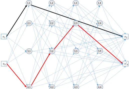
1.1.2 Example of MMRO problem and solution in graph
We illustrate the MMRO problem with the following example. The notation used is the one in the book of Wilson [11]. The MMRO problem has the following data:
• Set 𝑉𝑉 = {𝑣𝑣0, 𝑣𝑣1, 𝑣𝑣2, … , 𝑣𝑣30} has 31 nodes and is partitioned into 8 clusters, which 𝑐𝑐 = 7 clusters are costumers sets denoted by 𝑆𝑆𝑖𝑖, 𝑖𝑖 = 1, … 7 and the depot set 𝐷𝐷 =
{𝑣𝑣0, 𝑣𝑣1, 𝑣𝑣2}. Let 𝐼𝐼𝑆𝑆= {1, … ,7} be the costumers cluster index set.
• Sets 𝑆𝑆𝑖𝑖, 𝑖𝑖 = 1, … 7 have the same number of nodes: o 𝑆𝑆1= {𝑣𝑣3, 𝑣𝑣4, 𝑣𝑣5, 𝑣𝑣6}; o 𝑆𝑆2= {𝑣𝑣7, 𝑣𝑣8, 𝑣𝑣9, 𝑣𝑣10}; o 𝑆𝑆3= {𝑣𝑣11, 𝑣𝑣12, 𝑣𝑣13, 𝑣𝑣14}; o 𝑆𝑆4= {𝑣𝑣15, 𝑣𝑣16, 𝑣𝑣17, 𝑣𝑣18}; o 𝑆𝑆5= {𝑣𝑣19, 𝑣𝑣20, 𝑣𝑣21, 𝑣𝑣22}; o 𝑆𝑆6= {𝑣𝑣23, 𝑣𝑣24, 𝑣𝑣25, 𝑣𝑣26}; o 𝑆𝑆7= {𝑣𝑣27, 𝑣𝑣28, 𝑣𝑣30, 𝑣𝑣31}.
• All nodes in the cluster 𝑆𝑆𝑖𝑖, 𝑖𝑖 = 1, … 7 has the same demand with: 𝑑𝑑1= 50, 𝑑𝑑2= 2, 𝑑𝑑3 = 5, 𝑑𝑑4 = 1, 𝑑𝑑5= 20, 𝑑𝑑6= 6, 𝑑𝑑7 = 20.
• Two available vehicles with capacities 𝑄𝑄1= 15 and 𝑄𝑄2 = 75, respectivelly. Let 𝐿𝐿𝑘𝑘= ∞ and 𝑅𝑅𝑘𝑘= ∞ for both vehicles (no tour length constraint nor tour
duration limit are considered).
• Vehicle 1 start and end its tour on node 𝑣𝑣0. Thus 𝑆𝑆𝐷𝐷(1) = {𝑣𝑣0} and 𝐸𝐸𝐷𝐷(1) = {𝑣𝑣0}.
7 • Vehicle 2 start its tour at node 𝑣𝑣1 and must end at vertive 𝑣𝑣2 (𝑆𝑆𝐷𝐷(2) = {𝑣𝑣1} and
𝐸𝐸𝐷𝐷(2) = {𝑣𝑣2}).
• Consequently, 𝑆𝑆𝐷𝐷= {𝑣𝑣0, 𝑣𝑣1}, 𝐸𝐸𝐷𝐷= {𝑣𝑣0, 𝑣𝑣2} and 𝐷𝐷 = {𝑣𝑣0, 𝑣𝑣1, 𝑣𝑣2}.
• Set of arcs A does not contain arcs �𝑣𝑣𝑖𝑖, 𝑣𝑣𝑗𝑗� if 𝑣𝑣𝑖𝑖 and 𝑣𝑣𝑗𝑗 belong to the same cluster.
• The matrix cost 𝑊𝑊 can be any matrix, with adequate dimensions, with nonnegative values. The coefficient 𝑐𝑐𝑖𝑖𝑗𝑗 represents the human life value of the
object when it is located at the node 𝑖𝑖. The human life value can be defined as a time dependent function.
Figure 1. MMRO solution in the corresponding graph
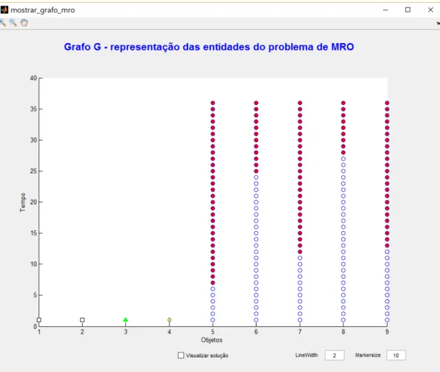
In the solution illustrated in Figure 1, it is possible to observe that a vehicle’s path can be a cycle. This can represent the tour made by a helicopter where it starts its tour from an airbase and returns there later. In the case of vessels, it is expected that they may desimbark survivors in a specific location, different from where they started their route. The example also shows that it is not mandatory to visit all clusters (cluster 𝑆𝑆5 is not
visited).
8 The example does not specify the conditions for allowing feasible arcs between nodes from different clusters. To model the object’s track through time (sequence of positions of a SAR object due to the maritime drift) and to avoid having routes where vehicles “travel back in time”, nodes will have a time stamp associated. Feasible arcs between clusters must satisfy the rule where the time stamp of the origin node is earlier than the time stamp of the destination node. This will be detailed in subsections 3.1.2 and 3.1.3.
1.2 Goals of the dissertation
This dissertation aims to answer the following question: “how to estimate the efficacy of a SAR system response to a mass rescue incident located in ocean waters using vehicle routing models?”. If the “vehicle routing models” part were not specified in the question, then a possible answer could be implicitly found in the IAMSAR manual [1, Sec. 5.6] that states how the efficacy of a SAR system can be measured. Since the efficacy indicator is measured by the ratio between two quantities associated with the number of lives involved in a certain mass rescue incident, the problem of estimating the SAR system efficacy is a statistical problem, that would be solved after the respective MRO is concluded. The challenge in answering this question stands with the complexity of the incident and its effects (number of persons alive after the accident, expected time of arrival of search and rescue units to the scene, SAR units recovery capacity, weather conditions and survivors drift, survival times, etc) and, most of all, the location of the incident itself. The distance of the incident location to SAR facilities is believed to have a crucial effect on the final rescue outcome. In this sense, using mathematical models to recreate possible incidents that would require a MRO at different locations and with specific effects is paramount for a Coastal State to assess their own maritime SAR capability. The first goal of this dissertation is to develop a tool to create instances of incidents that require an MRO and also to evaluate different solutions for those problems.
A vehicle flow based formulation is proposed to model a mass rescue operation in ocean waters. The fundamental questions that arise to such endeavor are related with the solutions characteristics and how these may, in fact, reproduce a real rescue operation and, most importantly, how can we recreate an incident using relevant data that meet the requirements for a mass rescue operation. For example, does the model cope with the dynamics of moving objects when they are subject to maritime drift? How the weather conditions are taken into consideration in the model (how they affect drifting objects and vehicle recovery times)? How to guarantee that the times required by vehicles for rescuing survivors or retrieving objects (rafts, lifeboats, etc.) from the water are realistic and comply
9 with the SAR experts judgement? These are modelling questions that must be analyzed and given a proper answer.
A second goal of this dissertation aims to study the procedures to retrieve drifting objects from the water and how these are influenced by available information on the scene. The procedure is defined by the sequence of choices made by SRUs in rescuing several dispersed survivors, which is associated to a priority rule (for example, a living person has has more priority than a deceased one when choosing who is to be retrieved from the water by a rescue boat). Particularly, we are interested in perceiving how the availability of survival time’s data can influence the overall efficacy of the rescue operation, if this information is available to be implemented in a rescue procedure at the tactical level (or on-scene level). Having multiple vehicles, conventional procedures for retrieving drifting objects from the water are based on the vehicle’s speed to reach the object’s location (assuming it can retrieve it). In this sense, the vehicles expected time arrival (ETA) to a specific object’s location stands as the “conventional” criteria (or standard priority) for obtaining a vehicle route and the respective sequence of retrieved objects. What if survival times were “available” to vehicles? Would a similar procedure based on the survival times provide better rescue solutions? These questions require the assumption that there is available technology that would provide the SAR system with the knowledge of the persons survival times and location with great accuracy. To answer these questions several variants of heuristics approaches are investigated that incorporate the priorities used by SRU vehicles during the recovery operations. To assess the quality of the heuristics that make use of standard priorities or available survival times, a more sophisticated heuristic approach based on a look ahead method is used for larger instances that cannot be solved optimally.
The final goal of this dissertation is to estimate the impact of SAR units availability on the SAR system response efficacy. Other variables, such has the location of the incident and the weather conditions, have critical impact on the SAR system response efficacy. Using the MMRO problem as an instrument to create instances with different effects, located at different distances from the SAR system facilities and with different SRU availability, can provide interesting data to assess the SAR system capability to deal with incidents that require an MRO and also provide arguments to support strategic decision concerning the aquisition of SAR equipment.
1.2.1 Summary of goals
10 • Develop a prototype to create instances of a maritime mass rescue problem
(MMRO) problem.
• Study a vehicle flow based formulation to solve the MMRO problem. One important aspect in using this approach stands with the size of the instances. The number of SAR objets and available vehicles limits the size of the MMRO instances that can be created and also solved.
• Study heuristic methods that replicate the priorities given to SRU for retrieving SAR objects from the water depending on available information, particularly survival times.
• Estimate the impact of the availability of SAR facilities on efficacy of the SAR system response.
1.3 Scope of the dissertation
Althought a MRO is considered a special SAR operation, the MMRO problem does not consider the search element. It is assumed that the location of the SAR objects are known at each moment in time. Search problems in the maritime environment have been studied since the Second World War and these problems are concerned with the allocation of search effort to maximize the probability of detection of a certain target.
The term “rescue” is defined in IAMSAR Manual [1, p. x] as “An operation to retrieve persons in distress, provide for their initial medical or other needs and deliver them to a place of safety”. This means a rescue operation can be viewed has having three distinct activities. The first one consists in retrieving persons in distress. The second one consists in providing for their initial medical needs and, the last one, involves delivering the retrieved persons to a place of safety. This dissertation only deals with the first activity: retrieving persons in distress. The other activities are not covered in this work and can also be viewed as optimization problems in the context of Disaster Operations Management (DOM). The problem of retrieving persons in distress located in ocean waters and subject to the maritime drift is refered as the maritime mass rescue operation (MMRO) problem. This problem consists in finding the optimal routes for a fleet of heterogeneous vehicles that minimizes a time dependent objective function. A solution for the MMRO problem provides information regarding persons retrieved alived and those who were retrieved and were allready deceased. In this problem it is assumed that the survival times are known and a person is considered to be rescued alived if it is retrieved before the moment it passes away. With the survival time information for each SAR object, it is possible to estimate the efficacy of the MMRO solution. The survival times are deterministic parameters in the MMRO problem and specified by the user when creating an instance.
11 Heuristics will be used for two distinct purposes. The first purpose is to replicate the priorities used by vehicles to retrive objects from the water. Two types of “priorities” are investigated. The first type, refered to as “standard procedure”, the SRU retrieves the nearest person in distress. When several SRU are available, the priority states that a person is recovered by the SRU that can reach the person’s location in less time. The second type of priority considers the availability of information regarding survival times and these are used by the SRUs when choosing the object to retrieve from the water. The second purpose in using heuristics is to solve large instances that cannot be solved within a limited amount of time and where a higher quality solution is required. For this later case we investigate the pilot method, proposed by Duin and Voss [12,13], to solve the MMRO problem.
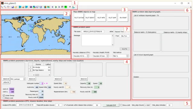
A prototype was developed using MATLAB language to create MMRO instances and test different heuristics to obtain solutions and assess their quality. The prototype uses several geographic information system (GIS) functionalities that allow the user to place a SAR object or a vehicle in a specific location on a map and calculate distances between objects to create a MMRO instance.
As a test bed for the MMRO instances, these were created within the Portuguese Search and Rescue Region (SRR), which is one of the largest SRR among European Coastal States. Most of the Portuguese SRR covers a great part of the north Atlantic Ocean. Oceanic and atmospherical data for estimating the object’s maritime drift is made available from the webservice Saildocs [14] which allows users to download Grib files produced by the NOAA/NCEP1 forecast models. Grib files are computer-generated forecast files from a
NCEP/NOAA computer, which are sent without review, and are offered on an as-is basis. Both Saildocs and the computer model itself are automated systems that provide grib data on a daily basis with a six hour interval update on the forecasts. The grib files used to create the MMRO instances were provided by the Portuguese Navy, who collects data for their SRRs on a daily basis. These files provide weather forecasts on a variaty of physical variables (wind speed, wind direction, pressure reduced to mean sea level, etc) measured on a grid between the parallels 10º and 45º north and the meridians 45º west and 5º east. The drift algorithm to estimate the objects drift through time was implemented in MATLAB and uses wind forecasts from Grib files. The drift algorithm is valid only for ocean waters since the wind current parameters available on the IAMSAR manual only apply for these case.
The SAR facilities corresponding to airbases used for the MMRO instances are Montijo airbase, Lisbon airport, located in the Portuguese Continent, and Porto Santo airbase,
12 located in Madeira archipelago. Two types of experiments are conducted in this dissertation. One experiment aims to answer the question whether information regarding survival times would influence positively the rescue efficacy or not. The second experiment consists in considering an hypothetical mass rescue incident with a large passenger cruise ship based on real data near Madeira island. To further understand the SAR system that operates on these SRR, a brief description of the Portuguese Maritime SAR System is included in Chapter 2.
1.4 Structure of the dissertation
Chapter 2 addresses the concept of maritime mass rescue operations and the mathematical models and heuristics used to model the MMRO problem. A brief description of the Portuguese maritime SAR system is made and special attention is given to vessels geospatial data that are used to create the instances of the MMRO problem. A survey on look-ahead methods with particular emphasis to the pilot method for combinatorial optimization problems are also presented.
Chapter 3 provides a description of the parameters of the maritime mass rescue operation problem and its data structures and how they are calculated. A binary linear programming formulation for a vehicle flow fomulation is presented. This formulation is based on a (huge) layered graph, discretized by time where arcs between time-indexed nodes are feasible only if the ships or helicopters are allowed to travel within the given time ranges. Computational results for several constructive heuristics and a pilot method variants are presented.
Chapter 4 presents a scenario based simulation where several instances of a MMRO problem are created based on real data regarding the location of a cruise ship during its transit between Funchal (Madeira Island) and Malaga (Spain) in April 2016. The consequences of the incident were designed and grouped into scenario variants in order to assess the efficacy of the SAR response using nearby vessels and the SAR helicopter stationed at Porto Santo airbase.
Chapter 5 discusses the heuristic performance based on the computational experiments and the limitations of the MMRO problem as an instrument to assess a SAR system efficacy to a MRO.
Finally, Chapter 6 summarizes our conclusions and suggests future research opportunities.
13 To facilitate the understanding of the concepts used in this dissertation, images, photos and diagrams are used in several figures. Whenever the content in a figure is not exclusively made by the dissertation’s author, the source of the content is refered below the figure’s caption.
14 THIS PAGE INTENTIONALLY LEFT BLANK
15
Chapter 2
Literature Review
2.1 Maritime mass rescue operations review
2.2 Related vehicle routing models and variants
2.3 Look-ahead methods for combinatorial optimization
problems
16 THIS PAGE INTENTIONALLY LEFT BLANK