www.scielo.br/rbg
UPPER QUATERNARY SEA LEVEL FLUCTUATIONS AND STILLSTANDS
ON THE CONTINENTAL SHELF OF S ˜AO PAULO STATE, BRAZIL: A SUMMARY
Valdenir Veronese Furtado
ABSTRACT.Sea level fluctuations are mainly related to glacial and deglacial events. S˜ao Paulo (Brazil) continental shelf shows many features, like terraces and sedimentary scarps, associated to older periods of sea level stillstands and drowned valleys, related to regressive and transgressive events. Although these features show well defined spatial position obtained through bathymetric analysis; they lack isotopic dating, which prevents from obtaining more accurate space-temporal positions. However, correlations with similar depths along the Brazilian continental shelf and the dating of a feature in the area enabled us to elaborate an estimated sea level variation curve for S˜ao Paulo continental shelf and coastal areas, since the Last Glacial Maximum.
Keywords: sea level fluctuations, bottom topography, sedimentary features, S˜ao Paulo continental shelf.
RESUMO.As flutuac¸˜oes relativas do n´ıvel do mar, de car´ater global, est˜ao associadas a eventos clim´aticos de glaciac¸˜ao e degelo. Embora n˜ao tenham ocorrido glaciac¸˜oes no hemisf´erio sul, durante o Quatern´ario, exceto na Ant´artica, a plataforma continental de S˜ao Paulo apresenta feic¸˜oes morfol´ogicas ligadas `a ´ultima gla-ciac¸˜ao e ao per´ıodo p´os-glacial subsequente. Caracterizam-se por terrac¸os e escarpas sedimentares, associados a per´ıodos de estabilizac¸˜oes do n´ıvel do mar e paleo-canais fluviais afogados, relativos ao ´Ultimo M´aximo Glacial e `a posterior transgress˜ao marinha. Essas feic¸˜oes, embora com posic¸˜oes espaciais bem definidas, atrav´es de an´alises batim´etricas, apresentam lacunas de datac¸˜ao isot´opica que n˜ao permitem o estabelecimento de posic¸˜oes espac¸o-temporais mais precisas. No entanto, correlac¸˜oes com profundidades similares ao longo da plataforma continental brasileira e datac¸˜ao de uma feic¸˜ao na ´area, permitiram a elaborac¸˜ao de uma curva tentativa de variac¸˜ao do n´ıvel do mar, desde o ´Ultimo M´aximo Glacial, para a plataforma continental de S˜ao Paulo e ´areas costeiras.
Palavras-chave: flutuac¸˜oes relativas do n´ıvel do mar, topografia de fundo, feic¸˜oes sedimentares, plataforma continental de S˜ao Paulo.
Departamento de Oceanografia F´ısica, Instituto Oceanogr´afico, Universidade de S˜ao Paulo, Prac¸a do Oceanogr´afico, 191, Cidade Universit´aria, 05508-900 Butant˜a, S˜ao Paulo, SP, Brazil. Phone: +55(11) 3091-6555 – E-mail: [email protected]
INTRODUCTION
Global sea level fluctuations are associated with glacial and deglacial events. The first eustatic curves prepared were, pre-sumably, global, since climate action was considered to be the sole responsible for the phenomenon. Although M¨orner (1976) considered glaciation and deglaciation as extremely important for the process, he also pointed out the relativity of the curves due to regional tectonic phenomena and geoid variation. M¨orner (op. cit.) observations prevent, therefore, the indiscriminate use of a eustatic curve at different locations.
The effect of sea level fluctuations on the continental shelf dur-ing the Quaternary has been extensively studied since the early 60s. The sub-aerial exposure of the shelf during marine regres-sions favors the action of the continental and coastal dynamics on the area. Channels are carved and terrigenous sediments are transported to the upper slope and, as the sea retreats, sequences of crests are formed on the exposed surface of the continental shelf. The equilibrium is displaced towards the coastal portion corresponding to the current shelf edge.
In the subsequent transgression, previously deposited con-tinental sediments are redistributed in equilibrium with the new environmental conditions. The drowning of terrigenous sediment sources inhibited their transfer to the outer portions, thus restrict-ing continental contribution to the coastal vicinity. Depositional sedimentary structures such as the old shoreface were totally or partially reworked, or even covered by transgressive sediments with expression only in sub-surface. Swift (1976) relates the presence of terraces on the continental shelf to a sea level still-stand occurred in the Holocene transgression. This author also considers that the presence of scarps is related to drowned shore-lines, being relics of lower shoreface partially eroded by faster transgressions. Slower transgressions would not allow its relief expressions on the surface, while submerged valleys can present surface expression or in subsurface caped by sediments.
Upper quaternary sea level fluctuations on the Brazilian continental shelf
Based on these assumptions, several studies have been con-ducted on the Brazilian continental shelf associating surface topographic expressions to sea level stillstands.
Notwithstanding the comments by M¨orner (1976), many studies due to the lack of more detailed information that would enable to elaborate a eustatic curve specifically for the Brazilian continental shelf, use the curve of Millimann & Emery (1968) to correlate the sediment samples of the area. This curve dates the last regressive maximum between 16,000 and 14,000 years
BP, reaching a depth of 130 meters. Other authors, such as MacIntyre et al. (1978) date the glacial maximum approximately 18,000 years BP, presenting data that corroborate the Curray curve (1965,apud MacIntyre et al., op. cit.). The last date has been currently adopted as the best to express the last regressive maximum. The achieved depth is about –125 m according to the curve of Curray (op. cit.). This position, however, cannot be used indiscriminately to correlate different areas.
Most of the studies about the Brazilian continental shelf are located in the Southeastern and Southern regions, as well as some observations at the mouth of the Amazonas River and Abrolhos region.
Kowsmann & Costa (1974) discuss sea level positions taking into account based on areas rich in coarse fraction terrigenous components. In the Southern region, the authors identified an area that extends from the shoreline to the 60-meter isobath and, considering the current lack of contribution from terrigenous, interpreted this outer boundary as formed by palimpsests sed-iments. They also identified a second area at –105 meters and a third one at –170 meters, and considered them as former sea level stillstands. The authors indicate terrigenous accumulation peaks at –50, –90/110 and –170 meters in the Northern region. However, there is no absolute dating of these levels.
Kowsmann et al. (1977) observed the occurrence of scarps at –60 and –110 m on the continental shelf of Rio Grande do Sul, which were associated with stillstand periods between 16,000 and 7,000 years BP. They also observed records of filled chan-nels on the S˜ao Paulo continental shelf.
Kowsmann & Costa (1979) examined evidence of sea level fluctuations on the Brazilian continental shelf and determined six stillstand levels, as follows:
a) –130 meters, dated to 15,000 years BP by14C method and comparatively placed according to the Millimann & Emery (1968) curve, consisting of carbonate sediments (bioclastic) and erosional terraces;
b) –110 meters, dated between 14,000 and 13,000 years BP by14C method, consisting of terrigenous sediments, shoreface cliffs and erosive terraces;
c) –90 and –75 meters, both dated between 12,000 and 11,000 years BP comparatively, according to the Milliman & Emery (op. cit.) curve, consisting of erosive terraces; d) –60 meters, dated to 11,000 years BP by 14C method,
consisting of terrigenous sediments, erosive terraces and Abrolhos paleolagoon (Vicalvi et al., 1975apud Kows-mann & Costa, 1979);
e) –40 meters, comparatively dated to 9,000 years BP ac-cording to the Milliman & Emery (op. cit.) curve, con-sisting of erosive terraces and scarps.
Corrˆea (1979) and Corrˆea et al. (1980, 1989), while analyz-ing bathymetric charts in detail, reported that the continental shelf that extends from Rio de Janeiro to Rio Grande do Sul display flattened features, which were associated to sea level stillstands during the transgressive process. These features are located from –20 to –25 m, –32 to –45 m, –60 to –75 m and –80 to –90 m. Corrˆea et al. (1980) proposed for the aforementioned levels the following ages, respectively: 7,500; 9,000 to 10,000; 11,000 and 11,500 years BP. The datings were calculated based on the Milli-man & Emery (op. cit.) curve.
Corrˆea (1990) places the sea level on the continental shelf of Rio Grande do Sul at the following positions: –120/–130 m, –100/–110 m, –60/–70 m, –32/–45 m and –20/–25 m dated to 17,500; 16,000 and 11,000 years BP, for the three deepest levels, respectively, and the interval between 11,000 and 6,500 years BP, for the two shallower levels.
Regarding the last regressive maximum, most studies about sea level fluctuations on the Brazilian continental shelf place it between 110 and 130 m below current sea level. These estimates were obtained from topographic evidence, occurrence of biode-tritic levels, terrigenous components and, in some cases, dat-ing followdat-ing the14C method. These datings, however, are not conclusive.
Kowsmann & Costa (1974), as previously indicated, dis-cussed the possibility of two positions for this regressive max-imum. The least probable, according to the authors themselves, places it at –170 m with a continental shelf subsidence rate of 0.3 cm/year; while the second, places it at –110, at a lower sub-sidence rate. Kowsmann et al. (1977) and Kowsmann & Costa (1978, 1979) analyzed cores, records of 3.5 KHz, organism asso-ciations and14C datings and concluded that the regressive maxi-mum can be placed at least 100 m below the current sea level, the most probable position when establishing correlations with the pre-existing eustatic curves being –130 meters. Corrˆea (1990) inferred a position –120/–130 meters through topographic and textural analysis.
Ocean bottom morphology and sea level fluctuations on S˜ao Paulo continental shelf
Studies about ocean bottom morphology have been made since the early 70s as shown in the works of Martins et al. (1972) and Zembruscki et al. (1972). A more accurate geomorpholog-ical characterization was performed by Zembruscki (1979) who
split the shelf into inner, middle and outer and identified the presence of gradients. For S˜ao Paulo northern shelf, this author defined a first slope that extends to the 60-m isobath, changing to a narrower inner shelf. The middle shelf is replaced by a sec-ond slope, which extends from 80 m to 100 m deep, and from there on, starts the outer shelf. This author also identifies a se-ries of shallow and narrow channels, approximately perpendicu-lar to the general slope, and suggests that they consist of paleo drainage developed in the regressive maximum at 18,000 years BP and drowned during Holocene transgressive events.
The studies about ocean bottom topography have also sought to relate expressions of submerged relief to eventual sea level still-stand periods as in Kowsmann et al. (1977), Corrˆea et al. (1989) and Corrˆea et al. (1996). The latter work extends to the S˜ao Paulo shelf the interpretations made by Corrˆea (1990).
Costa et al. (1988) while analyzing bathymetric charts in detail reported for the northern S˜ao Paulo shelf the presence of scarps at –60, –110 and –130 m.
The authors seek in these studies to correlate the submerged features to global curves and, as in the case of the study by Kows-mann et al. (1977), to a small number of datings.
Furtado et al. (1992) analyzed the Directory of Hydrogra-phy and Navigation (DNH) board charts for the S˜ao Paulo coast and defined five intervals that can be related to sea level still-stand periods. The first interval, between –15 and –20 m, could be associated with the current period. The second interval, be-tween –30 m and –40 m, could correspond according to the lit-erature, to 9,000 years BP. The third interval, between –60 m and –70 m could also according to the literature correspond to 11,000 years BP. The fourth interval, between –80 m and – 100 m, is correlated in the literature to ages between 11,000 and 12,000 years BP. The fifth interval at –130 m correlates, ac-cording to the literature, to an age of 17.420± 270 years BP dated for Rio Grande do Sul. However, according to the authors these ages are not accurate since there is no reliable dating for the S˜ao Paulo shelf.
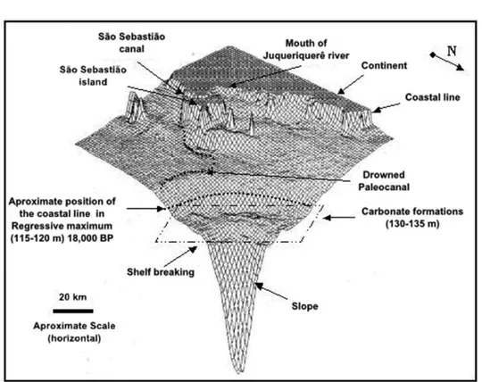
Several studies that seek to correlate the sedimentary mor-phological features of the S˜ao Paulo continental shelf to former sea level stillstands have used, as in Reinhardt et al. (1993), geo-referenced information systems, seeking to highlight the pres-ence of these features and checking the lateral extension. South of S˜ao Sebasti˜ao Island cliffs that extend westward between the 90 and 120 meter isobaths were observed. There is also a valley that extends from the southern entrance of the S˜ao Se-basti˜ao Canal towards the shelf breaking. This valley, identified by Zembruscki (1979), is associated to regressive periods and
Figure 1 – Digital terrain model of the north central continental shelf of S˜ao Paulo. Based on Furtado et al. (1996).
consequent sub-aerial erosion. Furtado et al. (1996) used a digi-tal terrain model (DTM) to detail the paleo-valley and considered it to be the main route to the sea ingression into coastal regions in the subsequent transgression. Currently, this submerged val-ley conditions the ingression of South Atlantic Central Water into coastal regions like the S˜ao Sebasti˜ao Canal (Fig. 1).
Furtado et al. (1993) based on the work of Reinhardt et al. (op. cit.), associate the topographic data to seismic records and sediments. The subsurface information allowed to identify sub-surface valleys caped by transgresive sedimentss; escarpment ar-eas where truncation of sedimentary layers are observed, similar to those occurring on beaches, due to on shore-off shore trans-portation; exposed rough surfaces, similar to the topography of beach sandstone; and, the presence of a high basement indicating a possible former barrier to the transgressive sea. These features indicate processes of sub-aerial erosion and possible former sea level stillstand.
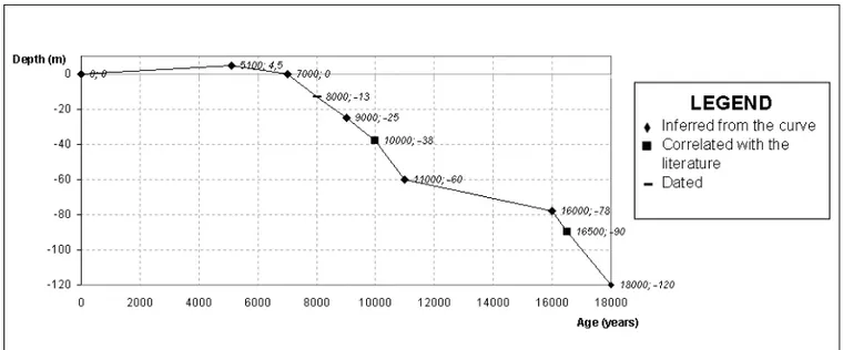
This study also identified an irregular surface between the bathymetric interval of –130 and –135 m, with slopes up to 15 meters presenting on the surface carbonate levels higher than 70%. This last area has been studied in more detail and Furtado et al. (1997), while analyzing sediment samples of this bathymet-ric interval, reported the occurrence of incrusted coralline algae and macro-foraminiferans, characteristic of a carbonate domain. The authors suggest through these indications a position for sea level stillstand at least 10 m above the shallower area (–130 m) and associate it to the last regressive maximum of approximately
18,000 years BP. It was possible from the existing data and ocean bottom topographic features to infer a sea level fluctuation curve from the last glacial maximum (Fig. 2). Although the data can support consistent hypotheses, they are not conclusive, but are goals to be researched in further projects that should be devel-oped in the area.
FINAL CONSIDERATIONS
There is a lack of data to adequately analyze the quaternary evo-lution of the continental shelf in S˜ao Paulo and its submerged coastal region.
The level of information about shallow structures and pale-olevel evidences, which permit to evaluate the process and its re-lation with sea level fluctuations, is still low.
There is practically no dating performed in the submerged area that enables to correlate sea paleolevels from a spatiotem-poral view point, and still, many paleo-surfaces are inferred from the abrasion terrace which in addition to not being time correlated, may include errors regarding their spatial position (on the depth at which the surface was eroded).
There is need for further research either obtaining subsur-face data that enable better identification of features correlated with sea level fluctuations or collecting materials amenable to dating, that allow a better spatiotemporal identification of even-tual stillstand levels and the development of a curve that repre-sents adequately the sea level fluctuations on the continental shelf of S˜ao Paulo.
Figure 2 – Curve inferred to describe the sea level stillstands on the continental shelf of S˜ao Paulo, after the last Glacial Maximum. Based on Vicalvi et al. (1978); Corrˆea (1996); Furtado et al. (1998) and Conti & Furtado (2001, 2006 and 2009).
ACKNOWLEDGMENTS
Thanks are due to Luis Am´erico Conti, Marcelo Rodrigues, Ro-berto Lima Barcellos and Jarbas Bonetti Filho who have been working with me on studies about sedimentation and sea level fluctuations on the continental shelf of S˜ao Paulo and contributed greatly to this work.
REFERENCES
CORRˆEA ICS. 1979. Paleolinhas de costa na plataforma continental entre S˜ao Paulo e Santa Catarina. In: Simp´osio Regional de Geologia, 2 ed. Atas. Rio Claro, SBG, 1: 269–278.
CORRˆEA ICS. 1990. Analyse morphostructurale et evolution paleogeo-graphique de la plateforme continentale atlantique sud-bresilienne (Rio Grande do Sul – Brasil). Universite de Bordeaux I. Doctorate. 314 pp. CORRˆEA ICS. 1996. Les variations du niveaux de la mer durant les derniers 17.500 ans BP: l’example de la plate-forme continentale du Rio Grande do Sul-Brasil. Marine Geology, 130: 163–178.
CORRˆEA ICS, PONZI VRA & TRINDADE LAF. 1980. N´ıveis marinhos quatern´arios da plataforma continental do Rio de Janeiro. In: Ed. Con-gresso Brasileiro de Geologia, 31. Proceedings. Cambori´u, SBG, 1: 578–587.
CORRˆEA ICS, BAITELLI R, SANTOS HM & ADE MVB. 1989. Sea levels changes in south brazilian continental shelf. In: International Sympo-sium on global changes in South America during the Quaternary: Past-Present-Future. Spec. Publ. no 1. S˜ao Paulo, Associac¸˜ao Brasileira de Estudos do Quatern´ario. 245–279.
CORRˆEA ICS, MARTINS LRS, KETZER JMM, ELIAS ARD & MARTINS R. 1996. Evoluc¸˜ao sedimentol´ogica e paleogeogr´afica da plataforma conti-nental sul e sudeste do Brasil. Notas T´ecnicas, 9: 51–61.
COSTA MPA, ALVES EC, PACHECO PG & MAIA AS. 1988. Prov´aveis estabilizac¸˜oes do n´ıvel do mar holocˆenico em trechos da plataforma con-tinental entre o norte de S˜ao Paulo e o sul do Rio de Janeiro, constatadas atrav´es de morfologia de detalhe. In: Congresso Brasileiro de Geolo-gia, 35, Proceedings..., Bel´em. Sociedade Brasileira de GeoloGeolo-gia, v. 2: 436–450.
MILLIMAN JD & EMERY KO. 1968. Sea levels during the past 35,000 years. Science, 162: 1121–1123.
FURTADO VV, MAHIQUES MM, REINHARDT D, BONETTI FILHO J, FIGUEIREDO Jr AG de & THEILEN F. 1993. Evidences of sea level fluctu-ation in the northern continental shelf of S˜ao Paulo State, Brasil. JOPS-I WORKSHOP, Niter´oi, RJ, Alfred Wegener Institute for Polar and Marine Research, Bremerhaven, Germany, 20 pp.
FURTADO VV, MAHIQUES MM & TESSLER MG. 1992. Utilizac¸˜ao de Feic¸˜oes topogr´aficas submersas na correlac¸˜ao de paleon´ıveis mari-nhos: uma avaliac¸˜ao. In: Congresso da Associac¸˜ao Brasileira de Estu-dos do Quatern´ario, 3 Proceedings... Associac¸˜ao Brasileira de EstuEstu-dos do Quatern´ario. Belo Horizonte, 175–186.
FURTADO VV, BONETTI FILHO J & CONTI LA. 1996. Paleo river val-ley morphology and sea level changes. Anais da Academia Brasileira de Ciˆencias, 68 (supl. 1): 163–169.
FURTADO VV, RODRIGUES M & BONETTI FILHO J. 1997. Estabilizac¸˜ao do n´ıvel do mar na plataforma continental do estado de S˜ao Paulo no ´ultimo m´aximo regressivo. In: VII Congresso Latino-Americano so-bre Ciˆencias do Mar, Associac¸˜ao Latino-Americana de Investigadores em Ciˆencias do Mar/Instituto Oceanogr´afico-USP, Santos, SP. Extended abstracts, 338–339.
FURTADO VV, BONETTI FILHO J, RODRIGUES M & BARCELLOS RL. 1998. Aspectos da sedimentac¸˜ao do Canal de S˜ao Sebasti˜ao. Technical report. Instituto. Oceanogr´afico, 43: 15–31.
KOWSMANN RO & COSTA MPA. 1974. Paleolinhas de costa na plata-forma continental das regi˜oes norte e sul brasileiras. Revista Brasileira de Geociˆencias, 4(4): 215–222.
KOWSMANN RO & COSTA MPA. 1978. Evidence of Late Quaternary sea level stillstands on the upper brazilian continental margin: a syn-thesis. In: 1978 International Symposium on Coastal Evolution in the Quaternary. Proceedings... SociedadeBrasileira de Geologia/Instituto de Geociˆencias-USP, S˜ao Paulo, p. 172–192.
KOWSMANN RO & COSTA MPA. 1979. Sedimentac¸˜ao quatern´aria da margem continental brasileira e das ´areas oceˆanicas adjacentes (Final report). S´erie Projeto REMAC 8. Petrobras. Rio de Janeiro, 55 pp. KOWSMANN RO, COSTA MPA, VICALVI MA, COUTINHO MGN & GAM-BOA LAP. 1977. Modelo de sedimentac¸˜ao holocˆenica na plataforma continental sul brasileira. In: Projeto REMAC. Evoluc¸˜ao sedimentar holocˆenica da plataforma continental e do talude sul do Brasil. S´erie Pro-jeto REMAC 2, Petrobras, Rio de Janeiro. 7–26.
MACINTYRE IG, PYLKEY OH & STUCKENRATH R. 1978. Relict oys-ter on the United State Atlantic continental shelf: a reconsideration of their usefulness in understanding Late Quaternary sea level history. Geol. Soc. Am. Bull., 89: 277–282.
MARTINS LR, URIEN CM & BUTLER LW. 1972. Prov´ıncias fisiogr´aficas e sedimentos da margem continental atlˆantica da Am´erica do Sul. In:
Congresso Brasileiro de Geologia, 26, Proceedings, Bel´em, Sociedade Brasileira de Geologia, 2: 105–114.
M ¨ORNER NA. 1976. Eustasy and Geoid Changes. J. Geol. 84: 132–151. REINHARDT D, BONETTI FILHO J, ALMEIDA TIR & FURTADO VV. 1993. An´alise de feic¸˜oes topogr´aficas submersas por meio de um sistema de informac¸˜oes geogr´aficas. In: Congresso da Associac¸˜ao Brasileira de Estudos do Quatern´ario, 4, Associac¸˜ao Brasileira de Estudos do Quatern´ario. S˜ao Paulo, SP, Resumos, p. 55–56.
SWIFT DJP. 1976. Continental Shelf Sedimentation. In: STANLEY DJ & SWIFT DJP (Eds.). Marine Sediments Transport and Environmental Management. John Wiley & Sons, Toronto, p. 311–377.
VICALVI MA, COSTA MPA & KOWSMANN RO. 1978. Depress˜ao de Abrolhos: uma paleolaguna holocˆenica na plataforma continental leste brasileira. Bol. T´ec. Petrobras, 21(4): 279–286.
ZEMBRUSCKI SG. 1979. Geomorfologia da margem continental sul brasileira e das bacias oceˆanicas adjacentes. In: CHAVES HAF (Ed.). Geomorfologia da margem continental brasileira (Final report) S´erie Projeto REMAC, 7, Rio de Janeiro, p. 129–177.
ZEMBRUSCKI SG, BARRETO HT, PALMA JC & MILLIMAN JD. 1972. Estudo preliminar das prov´ıncias geomorfol´ogicas da margem continen-tal brasileira. In: Congresso Brasileiro de Geologia, 26, Proceedings, Bel´em, Sociedade Brasileira de Geologia, 2: 187–210.
Recebido em 23 novembro, 2010 / Aceito em 27 abril, 2012 Received on November 23, 2010 / Accepted on April 27, 2012
NOTE ABOUT THE AUTHOR
Valdenir Veronese Furtado. Graduate in geology in the Instituto de Geociˆencia e Astronomia of the Universidade de S˜ao Paulo. Doctorade in geosciences in the Universidade de S˜ao Paulo. Livre Docˆencia at Institute of Oceanography. Specialization in coastal marine sedimentation. Worked at the Institute of Oceanography until 2010.