80
Palaeoecological evidence of agricultural activity and human impact on
the environment at the ancient settlement centre of Keava, Estonia
Atko Heinsalu and Siim Veski
Institute of Geology at Tallinn University of Technology, Ehitajate tee 5, 19086 Tallinn, Estonia; heinsalu@gi.ee
Received 14 April 2009, accepted 27 August 2009
Abstract. Peat record from a very small basin, the former mire of Verevainu, in the nearest vicinity of ancient Keava settlements (8th−11th centuries) and hillforts (5th–13th centuries), was investigated by means of palaeoecological approach, namely by pollen, charcoal, and loss-on-ignition analyses and radiocarbon dating. The study aimed at ascertaining the appearance of prehistoric man in the area and reconstructing the local vegetation history and human impact on the environment around the inhabitation centre. The first sporadic cereal pollen grains appeared in the sediments in the Late Bronze Age at ca 1500 BC. Both peat ignition residue values as indicators of topsoil erosion and pollen evidence suggest forest clearance, opening of landscape, and cultivation of cereals from the Pre-Roman Iron Age. Approximately at AD 350–500 the rate of human impact upon environment increased notably.
Key words: vegetation history, human impact, pollen, microscopic charcoal, peat mineral content, Keava, Estonia.
INTRODUCTION
The scarcity of archaeological artefacts and complexity of interpretation of such sources of information often make it necessary to collaborate in an interdisciplinary manner. Palaeoecological investigations, particularly pollen analysis, have greatly contributed to our knowledge of prehistoric environments and the manner in which human activity affected them (e.g. Veski 1998; Poska 2001; Poska et al. 2004). In Estonia long and well-established co-operation traditions have existed between palaeoenvironmental scientists and archaeologists (Veski & Lang 1996; Veski et al. 2005a) already since the times of Paul Thomson and Richard Indreko in the 1920s. Being one of the pioneers of the palynological analysis method, Thomson initiated a viable and continued tradition of palynological research in Estonia. In addition to describing post-glacial vegetation history on pollen assemblages from peat and lake sediments (e.g. Thomson 1929), he also applied pollen analyses in archaeological investigations (Thomson 1928).
However, quite often prehistoric settlements and other finds of archaeological source material and possible sediment archives, such as deposits of small-sized lakes and mires that mostly trap local natural and man-made environmental signals like wind-dispersed pollen grains, fire-induced microscopic charcoal particles, and erosion-generated soil dust particles, are located too far from each other. More local pollen signals can only be detected by investigations at small-scale sites (Broström et al. 1998; Veski et al. 2005b; Poska et al. 2008). Keava, an
ancient population centre with three settlement sites and two hillforts within the radius of 1 km, which were investigated by archaeological excavations conducted by Prof. Valter Lang, University of Tartu, during 2001−04, are located very close to small basins filled with sediments suitable for palaeoenvironmental studies.
Keava hillforts and settlements are located in Rapla County, 60 km south of Tallinn. Linnaaluste settlement is one of the largest Viking Age villages in the Baltic countries and definitely was an important centre in the past. For instance, chronicles mention the siege of Keava fortification by Prince Izyaslav of Novgorod in 1054. The German crusaders forced the hillfort to surrender during one of their raids in early 1224.
We have performed palaeoecological studies of sediment cores from two small mires, Verevainu and Linnaaluste, which are located in the immediate neighbourhood of the archaeological sites, where previous pollen studies or other palaeoecolocigal investigation are still lacking. Moreover, detailed pollen diagrams, which could reflect early indications of human impact on the environment, are absent from most of the inland areas of central Estonia.
81 GEOLOGICAL SETTING OF THE STUDY SITE
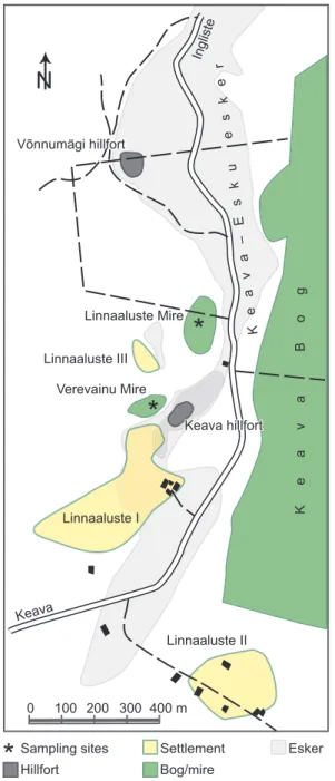
The configuration of the topography in the Keava area is closely associated with the retreat of the Weichselian ice sheet around 13 300 calendar years ago (Kalm 2006). The Keava–Esku esker (Fig. 1), a 2 km long ridge extending from south to north, is a striking landform of fluvioglacial origin, supposedly formed by in-glacier streams in ice-walled tunnels near the ice margin. The relative height of the esker is up to 17 m (altitude above sea level up to 86 m). The ancient steep-walled and flat-topped Keava hillfort is situated in the southern part of the esker. As seen from the nearby gravel-pit, the esker is formed of sand and overlying gravel.
East of the esker lies the large Keava Bog (surface area 1900 ha, maximum thickness of peat 8.8 m), the northwestern part of which is exploited for peat. The Quaternary deposits further westwards of the esker are dominated by tills and glaciolacustrine clays and sands. A coastal escarpment at an altitude of 73 m a.s.l. near Keava (Rähni 1976) is a firm evidence that waters of the Baltic Ice Lake inundated the study area, however, the highest parts of the esker formed a small-sized archipelago.
Besides the large Keava Bog, several minor hollows with peat infilling occur in the vicinity of the Keava settlement centre. One of them is located at the foot of the Keava hillfort just north of Linnaaluste I settlement. The former mire (58°57′03″N; 24°56′48″E; Fig. 1) with a size of 100 m × 150 m, which we call Verevainu Mire, is drained, reclaimed, and transformed into pasture, whereas the edge of the fen close to the hillfort is over-grown with bushes of alder and willow. The topmost peat layer has been destroyed during land amelioration works and desiccation/oxidation of the peat has resulted from the drainage of the peat bog. In addition to the proximity to the Keava hillfort, Verevainu Mire lies less than 100 m from other archaeologically significant Early Viking Age/Viking Age settlements Linnaaluste I and III (Fig. 2).
As the record covering the last thousand years of the Verevainu Mire peat sequence has been destroyed due to ditching and land amelioration, a second peat sequence from the mire that we call Linnaaluste Mire was chosen for investigation to complement the missing upper part of the Verevainu Mire. The Linnaaluste Mire (58°57′11″N; 24°57′00″E; Fig. 1) is situated 300 m north of the Keava hillfort. This small oval-shaped mire with a size of 80 m × 150 m is today covered with pine forest.
METHODS
In July 2002, a set of replicate sediment cores was taken from the Verevainu Mire using a 7.5 cm diameter and
0 100 200 300 400 m
Keava
Ingliste
Keava Bog
Linnaaluste I
Linnaaluste II Linnaaluste III
Verevainu Mire
K
e
a
v
a
–
E
s
k
u
e
s
k
e
r
Linnaaluste Mire Linnaaluste Mire
Linnaaluste Mire
Keava hillfort Keava hillfort
Keava hillfort
Sampling sites
Võnnumägi hillfort Võnnumägi hillfort
Võnnumägi hillfort
Hillfort
Settlement
Bog/mire
Esker
N
Fig. 1. Location of the sites mentioned in the text. The asterisks
mark the coring sites.
82
Peat composition was determined by loss-on-ignition measurements. The sediment core of the Verevainu Mire at a depth of 18−130 cm was sectioned into consecutive 2 cm subsamples and the whole core of the Linnaaluste Mire was cut into 2 cm segments. The subsamples were
dehydrated at 100°C for 24 h, weighed, then combusted
at 550°C for 4 h and re-weighed to determine the organic
content of the peat and ignition residue (IR), i.e. the mineral content of the peat.
Samples for pollen analysis were processed using standard procedures (Berglund & Ralska-Jasiewiczowa
1986). Known quantities of Lycopodium spores were
added prior to digestion to permit calculation of pollen concentration and accumulation rates (Stockmarr 1971). The sample residue was then mounted on microscope slides with glycerol. Pollen grains were routinely counted and identified at 320× magnification; for determination of
cereal pollen grains 1000× magnification, oil immersion,
and phase contrast were used. Pollen grains were identified to the lowest possible taxonomic level using
the reference collection held at the Institute of Geology at Tallinn University of Technology and published pollen keys (e.g. Fægri & Iversen 1989; Reille 1992). A minimum of 500 grains were counted in each sub-sample. Pollen percentages were calculated as in Veski (1998), and pollen diagrams were compiled and plotted using the TILIA and TILIA-GRAPH software (Grimm 1990, 2004).
The pollen slides were also examined for micro-scopic charcoal particles. Two different charcoal size
groups were distinguished – the 10−100 µm and >100 µm
fractions.
The chronology of the Verevainu Mire core is based on three conventional radiocarbon dates and
that of the Linnaaluste Mire on two conventional 14C
dates. All dates were obtained from 5 cm thick bulk ombrotrophic peat samples. The radiocarbon dates were converted to calendar years using the IntCal04 calibration dataset (Reimer et al. 2004) and OxCal 4.0 program deposition model (Bronk Ramsey 2001, 2008) with the
Fig. 2. Aerophoto from 1936 of the study area (Photo No. 4028, archive of the Tallinn University, Institute of History) with the
83
2σ (95.4% confidence) level. In order to construct an
age–depth model, weighted average estimates of the probability distributions of the calibrated age were calculated. All ages mentioned in this text are given in calendar years BC or AD.
LITHOSTRATIGRAPHY AND DATINGS
The stratigraphy for the two studied sites is described in Table 1. The basal minerogenic sediments in both mire depressions possibly deposited in the Baltic Ice Lake. A thin 12 cm layer of coarse detritus gyttja suggests that a
shallow lake existed in the Verevainu basin before the limnic environment completely filled in and changed to telmatic environment, first as an open fen and thereafter as an ombrotrophic bog. Sediment stratigraphy of the Linnaaluste Mire revealed that the basin lacked the Early Holocene shallow limnic environment. Instead, peat deposition took place.
Altogether five radiocarbon datings were obtained, three from the Verevainu Mire and two from the Linnaaluste Mire (Table 2). The results from the Verevainu Mire showed that the uppermost 120 cm accumulated during the last ca 5500 calibrated years BP. The applied age–depth model showed that the average
Table 1. Lithostratigraphy of the sediment sequences from the Verevainu and Linnaaluste mires
Depth from the surface,
cm
Sediment description Environment
Verevainu Mire
0–15 Humus, dark Drained and reclaimed peat bog
15–35 Sphagnum peat, dark brown, in the lower boundary sand grains,
probably sediment mixed during land amelioration
Treeless transitional bog
35–77 Sphagnum peat, brown, poorly decomposed Treeless transitional bog
77–170 Wood–Sphagnum peat, dark brown, fairly decomposed,
0.1–0.2 cm thick charcoal layers at 101, 96, and 81 cm
Forested transitional bog
170–210 Wood–Phragmites peat, brown, poorly decomposed Forested swamp
210–277 Fen moss peat, light brown, poorly decomposed Open fen
277–339 Phragmites peat, brown, fairly decomposed Open fen
339–351 Gyttja, greenish-brown, abundant coarse detritus Shallow lake
351–388 Silt, greyish-green Baltic Ice Lake?
Linnaaluste Mire
7–27 Sphagnum peat, brown, fairly decomposed Mire
27–96 Eriophorum–Sphagnum peat, dark brown, fairly decomposed,
0.1–0.2 cm thick charcoal layers at 81, 62, 56, 50, 46, 42, 38, 35, and 27 cm
Mire
96–138 Peat, almost completely decomposed Mire
138–144 Silt with organic material, grey Baltic Ice Lake?
144–162 Silt, grey Baltic Ice Lake?
Table 2. Radiocarbon datings from the studied peat sequences at Keava
Depth from the surface,
cm
Laboratory code 14C age,
years BP
Calibrated age, 95.4% probability
Archaeological period
Verevainu Mire
55–60 Tln–2727 1590±55 AD 345–595 Late Roman Iron Age/Migration Period
80–85 Tln–2726 2465±60 BC 765–410 Early Bronze Age/Early Roman Iron Age
115–120 Tln–2728 4455±55 BC 3345–2930 Middle Neolithic/Late Neolithic
Linnaaluste Mire
46–52 Tln–2756 3690±70 BC 2285–1895 Late Neolithic
84
peat accumulation rate was 0.1 mm yr−1
in the lower part, 0.2 mm yr−1
in the middle part, and 0.4 mm yr−1
in the upper part of the sediment sequence.
The datings from the Linnaaluste Mire sediment sequence indicate that the peat profile down to a core-depth of 95 cm covers approximately the last 8700 calibrated years BP, i.e. point to the fact that the origin of this basin is not related to the Subatlantic wet conditions as we expected, but is much older and almost covers the entire post-glacial period. Owing to the very low sedimentation rate (less than 0.1 mm yr−1
) and there-fore poor resolution of the record, we could not use that sediment sequence for complementing the missing sub-surface archive of the Verevainu Mire for the last thousand years in a proper way.
VEGETATION AND LAND USE HISTORY
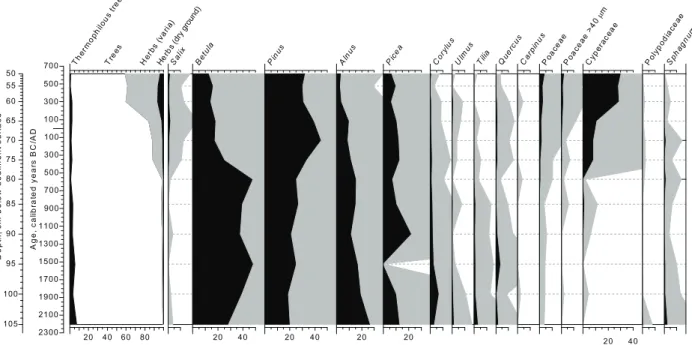
The environmental and general vegetation history, with special emphasis on the impact of human habitation of the Keava area, is mostly based on the pollen diagrams (Figs 3, 4) and IR curve (Fig. 5) from the ancient Verevainu Mire, covering the time-span from 3500 BC to about AD 1500 (IR) and from 2200 BC to about AD 600 (pollen). Additional information on vegetation history is based on pollen evidence from the Linnaaluste Mire (Fig. 6).
From about the Late Neolithic ca 2000 BC, the Keava area was forested and mixed forest of Betula
(birch), Pinus (pine), and Picea (spruce) grew on dry ground, whereas Alnus (alder) formed alder thickets around the Verevainu (Fig. 3) and Linnaaluste mires on wet ground (Fig. 6). Broad-leaved trees, particularly Quercus (oak), Corylus (hazel), and Tilia (lime), were more abundant than today but rather rare. In general, the pollen diagrams indicate very low non-tree pollen values (herbs) without any evident changes. Moreover, the tree pollen curves do not show any apparent disturbances of the forest cover and imply that there was no particular human impact and agriculture in the nearest vicinity of the studied area. The tree pollen accumulation rate was also high, indicating closed conditions.
In small ombrotrophic Sphagnum-dominated peat bogs deposition of mineral particles often reflects soil erosion associated with human activity in the vicinity of the bog (e.g. Vuorela 1983; Dörfler 1992). Mineral material originates from particles transported by wind and rain and consists mainly of particles derived from eroding soils. Smaller peat bogs closer to cultivated fields have greater ability to trap mineral soil influx arising from human-induced soil erosion. Therefore peat profiles of small-sized bogs are expected to be especially suitable for the investigation of ancient human agricultural activity. Ombrotrophic peat bogs, dominated by Sphagnum mosses, are solely fed by atmospheric deposition, i.e. they receive all of their water, nutrients, and mineral particles from precipitation falling directly on their surfaces. Ombrotrophic peat studies in Estonia have shown that in natural conditions the content of organic matter in
700
500
300
100
100
300
500
700
900
1100
1300
1500
1700
1900
2100
2300
A
ge,
c
al
ibr
at
ed y
ear
s
B
C
/A
D
50 55 60
65
70
75
80
85
90
95
100
105
D
ept
h,
c
m
bel
ow
s
edi
m
ent
s
ur
fac
e
20 40 60 80
Th erm
op hilo
us t ree
s
Tre es
He rbs (
vari a)
Her bs (dry ground)
Sa lix
20 40
Be tula
20 40
Pin us
20
Aln us
20
Pice a
Co rylu
s
Ulm us
Tilia Qu erc
us
Ca rpin
us
Po acea
e
Po acea
e > 40
µm
20 40
Cy pe
rac eae
Po lyp
od iace
ae
Sp ha
gnu m
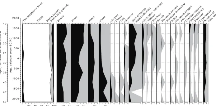
Fig. 3. Percentage pollen diagram of selected taxa from the Verevainu Mire sediment profile. The grey curves show 10×
85
Sphagnum-dominated bogs is very high and regular, whereas the proportion of mineral matter is low, less than 5%. In transitional bog peat IR values are slightly higher, 5−10% (Valk 1988). We have to consider that the past Verevainu Mire was similar to the transitional type of bogs, therefore it was not solely fed by atmo-spheric deposition but also received moisture by means
of groundwater seepage from the slopes of the esker. In the Verevainu Mire peat sequence from about 3500 BC to ca 1100 BC the IR values are low (7−8%) and fluctuations are lacking (Fig. 5), thus additionally implying native forests without any clearings of wood-land and mineral soil influx arising from soil erosion induced by ancient agricultural activity.
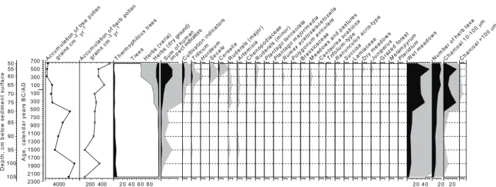
700 500 300 100 100 300 500 700 900 1100 1300 1500 1700 1900 2100 2300 A ge, c al endar y ear s B C /A D 50 55 60 65 70 75 80 85 90 95 100 105 D ept h, c m bel ow s edi m ent s ur fac e 4000 Acc um ulat ion of
tree po llen
g rain
s cm -2 yr
-1 200 400 Acc um ula tion of herb po llen g rains cm -2 yr
-1
2 0 4 0 6 0 8 0
Th erm oph ilous tre es Tre es He rbs (
vari a)
He rbs (
dry ground)
Sum of h
um an
im pact indicators
Cul tivat ion i ndi cat ors Trit icu m Hor deum Seca le Ce rea lia Cent aur ea s cabi osa Ruder als (
maj or) Arte mis ia Cheno podi acea e Ruder als (
min or) Plant ago lanc eol ata Plant ago m ajor /medi a Rum ex ac
etos a/ac eto sella Pol ygonum av icul are Bra ssica ceae Mea dow s and pa stur es Trif oliu m-t ype Ranun cul
us ac ris-t
ype Succi sa Lam iac eae Dry meado ws Juni perus Gra zed f ores t Me lam pyr um Pte ridiu
m
2 0 4 0
Wet meado ws 2 0 Num ber
of her b ta
xa 2 0 Char coal 10-100 µm Char coa l >1 00 µm
Fig. 4. Human impact diagram from the Verevainu Mire sediment profile. Pollen accumulation rate (grains cm−2 year−1) of tree
and herb pollen and percentage of selected pollen taxa/pollen groups and percentage of microscopic charcoal are plotted.
Grouping of pollen types into different land-use categories after Poska et al. (2004). The grey curves show 10 × exaggeration of
the percentage values.
2000 1500 1000 500 0 500 1000 1500 2000 2500 3000 3500 4000 Accumulation of tree pollen, grains • cm-2• yr-1
Sum of human impact indicators, % Charcoal, %
Ignition residue, %
Verevainunu MireMire
Verevainu Mire Linnaaluste Linnaaluste MireLinnaaluste MireMire
Sum of human
impact indicators, % Charcoal, % Ignition residue, %
N BA PRIA RIA MIA VA LIA MED Archaeological periods Archaeological events at Keava
Lelle bronze axe Võnnumägi hillfort, Käbiküla and Koogimäe settlements Linnaaluste I-III settlements
Age, calendar years BC/AD
Keava hillfort
5 10 15 20 0 10 20 4000 8000 0 2 4 6 2 4 6 2 4 6 2 4
Keava initial hillfort
fortifications settlements
Fig. 5. Summary proxy data describing the human impact on the environment at Keava. Percentage of ignition residue,
86
The first single cereal pollen finds (Fig. 4) of Triticum-type (wheat) pollen appeared during the Early Bronze Age ca 1500 BC together with cultural indicators such as apophytes Artemisia (wormwood) and Taraxacum type (dandelion). The pollen evidence suggests that small-scale attempts at crop tillage may have been made, but the human population possibly living in the Keava area was scarce and did not significantly influence the plant cover structure and local environment. In addition, an isolated find of an Early Bronze Age bronze axe (Jaanits et al. 1982) from Lelle, ca 10 km south of the study area, implies preferably a small and highly dispersed human population in the area rather than the absence of people.
Recent records of Triticum-type pollen accompanied by Cannabis-type (hemp) pollen ca 5600 BC at Akali, middle eastern Estonia, by Poska & Saarse (2006) can be interpreted as the first possible traces of the acquaintance of foragers with crop farming through contacts with southern European agrarian tribes already in the Late Mesolithic. During the Bronze Age, crop cultivation already played an important role in the farming economy in northern Estonian coastal alvar areas, e.g. in Maardu (Poska et al. 2004), Kahala (Poska & Saarse 1999), and Mustjärve (Veski 1998). However, the inland parts of northern and central Estonia were obviously economically marginal areas during the Bronze Age. The first sporadic finds of cereal pollen grains, namely Triticum and Avena type (oat) were detected in the pollen diagram from Ruila, ca 40 km northwestwards
of Keava in the early Bronze Age ca 1500 BC (Poska & Saarse 2002), i.e. at the same time as in Keava.
The Verevainu Mire pollen diagram indicates that the landscape around Keava remained constantly forested primarily with birch, pine, and spruce trees without considerable fluctuations in the tree population, arboreal pollen accumulation, and disturbances in the woodland structure until 350 BC, followed by an abrupt change in the pollen record. A sharp and persistent rise in total herb pollen percentage and somewhat higher herb pollen accumulation with corresponding decrease in the tree pollen accumulation possibly suggest degeneration of forests and a change towards partially open landscape. Not only a decrease in tree pollen percentage was seen, but also tree pollen accumulation rates reduced 2−3 times, indicating major ecological changes in the vicinity of Keava, recession of forest, and opening of the landscape. The distribution of non-tree vegetation and opening up of the landscape were evidently reached by clearance combined with the effects of fire, as indicated by high values of charcoal particles. Somewhat earlier, at ca 600 BC, the pollen curve of cereals contains only few grains of Triticum type. However, the curve remains unbroken, pointing to crop cultivation at least in limited areas close to the Verevainu Mire and is likely associated with the appearance of permanent fields (Lang 1994). The pollen evidence also has additional clear signs of human activities, such as Artemisia, Chenopodiaceae (goosefoot family), ruderals, Plantago types (plantains), and Juniperus (juniper), suggesting creation of pastures,
2 0 0 0
1 5 0 0
1 0 0 0
5 0 0
0
5 0 0
1 0 0 0
1 5 0 0
2 0 0 0
A ge, c al endar y ear s B C /A D 1 0 1 5 2 0 2 5 3 0 3 5 4 0 4 5 5 0 D ept h, c m bel ow s edi m ent s ur fac e
2 0 4 0 6 0 8 0 1 0 0
The
rmo
philou
s tr
ees
Tree
s
He
rbs (v
aria
)
He
rbs (d
ry g
rou
nd)
2 0 4 0
Bet ula
2 0 4 0
Pinu s 2 0 Alnu s 2 0 Pice a Co rylu s Ulmu s TiliaQuer
cus
Sum
of hum
an impact i ndi cato rs Cu ltivat ion ind ica tors Trit icum Ho rdeu m Sec ale Rude
rals (
min or) Plan tago lanc eol ata Urtic a Rude
rals (
maj or) Arte mis ia Chen opo diac eae Wet meado ws Poa cea e Cype race ae Num ber of h erb tax a
Fig. 6. Percentage pollen diagram of selected taxa from the Linnaaluste Mire sediment profile. The grey curves show 10×
87 forest grazing, and onset of the formation of an agrarian
landscape at Keava in the Early Pre-Roman Iron Age (Fig. 5).
The deforestation and opening up of landscape leading to reduction in plant cover may have contributed to topsoil disturbances and increased erosion intensity. However, the mineral content of the peat of the Verevainu Mire starts to increase and a rise in IR values is steady somewhat earlier than observed in the pollen evidence, from around 1000 BC (Fig. 5), which might indicate elevated fluxes of soil dust resulting from man-induced soil erosion. The earlier indication of human interference, detected more sensitively by the erosion signal rather than by pollen evidence, may result from the relatively coarser sampling interval employed for pollen analyses than for loss-on-ignition analyses of the Verevainu Mire profile, as well as from the fact that early cultivation signals are very weak.
The pollen evidence from the Linnaaluste Mire (Fig. 6) in general mimics that from the Verevainu site, only the Pre-Roman Iron Age human impact was slightly weaker, the signal of microscopic charcoal was insub-stantial, and no major changes occurred in the tree cover. These features suggest that possibly the Linnaaluste basin was a bit too far away from the main human activities and the proximate edge of the mire remained forested, filtering the pollen signal.
Recent archaeological discoveries at a nearby fortification site of Võnnumägi, namely five radiocarbon dates on charcoal and finds of coarse-grained and striated ceramics, suggest that the hillfort is of Pre-Roman Iron Age (Lang et al. 2005). Although settlement layers of that age in Keava are still controversial, we assume that hillforts were not erected in uninhabited areas and people settled in the region, which is inconsistent with the timing of increased arable and pastoral farming evidence during the Pre-Roman Iron Age in the Verevainu pollen diagram. Moreover, recent archaeological field surveys have revealed several settlement sites, such as Käbiküla and Koogimäe, in the vicinity of Keava that presumably date from the same period (Lang & Konsa 2004). Both archaeological and palaeoecological evidence implies colonization of former marginal lands in the Keava area and suggests implementation of crop farming, exploitation of landscape, and significant change in the natural vegetation composition during the Pre-Roman Iron Age around 350 BC. Moreover, this is consistent with an earlier consideration that the cereal cultivation had expanded spatially into more extensive areas in inland Estonia by the Iron Age (Poska et al. 2004; Saarse et al. 2010).
The overall impression from the pollen and soil erosion data implied only insignificant expansion of agri-cultural activities from 350 BC to AD 300. However, around AD 300 the pollen record provided distinct
evidence of increase in both arable and pastoral farming activity in the area. The landscape in the vicinity of Keava was progressively cleared, as tree pollen decreased notably and herb pollen increased. Herbaceous pollen that was recorded at higher frequencies includes mainly Cyperaceae, Poaceae, but also Rumex (sorrel), Taraxacum and others, as well as indicators of grazing like Juniperus and Pteridium (ferns), which may hint at pastoral farming. Pollen evidence for arable farming continued to increase as an abrupt rise in cereal pollen in the pollen diagram, which showed intensified cultivation farming. Moreover, new crops, such as Secale (rye) and Hordeum (barley), were introduced. These changes coincided with a short-lived peak of microscopic charcoal, which might have resulted from slash and burn close to the study site. Throughout this period, which lasted from AD 300 to 600, microscopic charcoal was present at very high values; in addition, charcoal occurred in macroscopic form, which suggested very local origin.
The comparison of the IR curve with the respective human-impact indicators in the pollen record from the study site showed a clear link to human land use at the time of IR peaks. The IR content continued to increase until AD 350 and afterwards, showing that the topsoil erosion and wind-blown accumulation of mineral dust particles in the Verevainu Mire had drastically increased. The data suggest considerable deforestation and destruction of vegetation, and the increasing intensity of agricultural practices in the Late Roman Iron Age, in the Migration Period, and in the Pre-Viking Age.
The topmost subsurface sediment record of the Vere-vainu Mire was visibly disturbed and therefore pollen analysis further upwards was not performed. In addition, the irregular shape of the IR curve after AD 1000 should be interpreted with some caution. However, judging in particular from the rising percentage of charcoal in the Linnaaluste Mire sediment record (Fig. 6), extensive deforestation and expansion of arable farming during the Viking Age and in the early 13th century can be expected.
88
CONCLUSIONS
Pollen, charcoal, and loss-on-ignition analyses from the peat section located in the immediate neighbourhood of the ancient settlement centre of Keava revealed the local history of vegetation and clear evidence of human-induced disturbances on the environment. From about 2000 BC, natural birch–pine–spruce forest cover surrounded the Keava area. The first Triticum pollen grain at ca 1500 BC points to the earliest date for the arrival of agriculture in the Keava area, however human population possibly living there was small and did not influence the local environment. Pollen data combined with the high values of charcoal particles suggest forest clearance, opening of landscape, and cultivation of cereals and thus provide convincing evidence of the increasing population and expansion of agriculture during 600−300 BC, however, peat IR values as an indicator of topsoil erosion started to increase even earlier, from around 1000 BC. Following a certain period of standstill in human-induced impact on the environment, the indicators of sediment record disturbance inferred a new major expansion of arable farming at AD 300−600. The high anthropogenic impact on the landscape, evidenced by the palaeoecological record during the Pre-Roman Iron Age and the Late Roman Iron Age/Migration Period, distinctly predates extensive archaeological settlement data until the Pre-Viking Age.
Acknowledgements. Funding for this research was provided by the Estonian Ministry of Education and Research (SF0332710s06) and the Estonian Science Foundation (grant No. 6995). Helerin Heinsalu helped in the coring and measured loss-on-ignition on samples from the Verevainu Mire. Holger Koot analysed several sediment samples from the Linnaaluste Mire for pollen and loss-on-ignition as part of his Bachelor
studies. Dr Laimdota Kalninaand an anonymous reviewer are
thanked for constructive comments and suggestions on the manuscript.
REFERENCES
Berglund, B. E. & Ralska-Jasiewiczowa, M. 1986. Pollen analysis and pollen diagrams. In Handbook of Holocene Palaeoecology and Palaeohydrology (Berglund, B. E., ed.),
pp. 455−484. John Wiley and Sons, Chichester.
Bronk Ramsey, C. 2001. Development of the radiocarbon
calibration program OxCal. Radiocarbon, 43, 355−363.
Bronk Ramsey, C. 2008. Deposition models for chronological
records. Quaternary Science Reviews, 27, 42−60.
Broström, A., Gaillard, M.-J., Ihse, M. & Odgaard, B. 1998. Pollen-landscape relationship in modern analogues of ancient cultural landscapes in southern Sweden – a first step towards quantification of vegetation openness in the
past. Vegetation History and Archaeobotany, 7, 189−201.
Dörfler, W. 1992. Radiography of peat profiles: a fast method for detecting human impact on vegetation and soils.
Vegetation History and Archaeobotany, 7, 93−100.
Fægri, K. & Iversen, J. 1989. Textbook of Pollen Analysis. 4th Edition (Fægri, K., Kaland, P. E. & Krzywinski, K., eds). John Wiley & Sons, Chichester, 328 pp.
Grimm, E. C. 1990. TILIA 2.0, Software. Illinois State Museum, Springfield.
Grimm, E. C. 2004. Tilia Graph v. 2.0.2, Software. Illinois State Museum, Research and Collection Center, Springfield.
Jaanits, L., Laul, S., Lõugas, V. & Tõnisson, E. 1982. Eesti
esiajalugu [Estonian Prehistory]. Eesti Raamat, Tallinn, 469 pp. [in Estonian].
Kalm, V. 2006. Pleistocene chronostratigraphy in Estonia, southeastern sector of the Scandinavian glaciation.
Quaternary Science Reviews, 25, 960–975.
Konsa, M., Lang, V., Lainemurd, I. & Vaab, H. 2002.
Archaeological excavations at settlement site I of Linnaaluste. Archaeological Fieldwork in Estonia 2001,
74−81.
Konsa, M., Lang, V. & Loolaid, L. 2003. Settlement site III of Linnaaluste from archaeological complex of Keava.
Archaeological Fieldwork in Estonia 2002, 51−55.
Lang, V. 1994. Celtic and Baltic fields in North Estonia. Fossil field systems of the Late Bronze Age and Pre-Roman Iron Age at Saha-Loo and Proosa. Acta
Archaeo-logica, 65, 203–219.
Lang, V. & Konsa, M. 2004. Time and change in inter-disciplinary site studies as revealed by settlement history
of the Keava area. Muinasaja Teadus, 14, 113−135 [in
Estonian, with English summary].
Lang, V. & Kriiska, A. 2001. Periodization and chronology of
Estonian prehistory. Journal of Estonian Archaeology, 5,
83−109 [in Estonian, with English summary].
Lang, V., Konsa, M., Tvauri, A., Kaldre, H., Laneman, M., Lätti, P. & Vaab, H. 2004. Two Iron Age hill-forts, a settlement site and Neolithic birch bark pavement of Keava. Archaeological Fieldwork in Estonia 2003,
61−71.
Lang, V., Laneman, M., Kaldre, H., Konsa, M. & Tvauri, A. 2005. From the Early Pre-Roman Iron Age to the early modern times: new investigations at Keava.
Archaeo-logical Fieldwork in Estonia 2004, 45−58.
Poska, A. 2001. Human impact on vegetation of coastal Estonia during the Stone Age. Comprehensive Summaries of Uppsala Dissertations from the Faculty of Science
and Technology, 652, 1−48.
Poska, A. & Saarse, L. 1999. Holocene vegetation and land-use history in the environs of Lake Kahala, northern
Estonia. Vegetation History and Archaeobotany, 8,
185−197.
Poska, A. & Saarse, L. 2002. Biostratigraphy and 14C dating of
a lake sediment sequence on the north-west Estonian carbonaceous plateau, interpreted in terms of human impact in the surroundings. Vegetation History and
Archaeobotany, 11, 191−200.
Poska, A. & Saarse, L. 2006. New evidence of possible crop introduction to north-eastern Europe during the Stone Age. Cerealia pollen finds in connection with the Akali Neolithic settlement, East Estonia. Vegetation History
89
Poska, A., Saarse, L. & Veski, S. 2004. Reflections of pre- and early-agrarian human impact in the pollen diagrams of
Estonia. Palaeogeography, Palaeoclimatology,
Palaeo-ecology, 209, 37−50.
Poska, A., Sepp, E., Veski, S. & Koppel, K. 2008. Using pollen based quantitative land-cover estimations and CA_Markov model to reconstruct the development of cultural landscape at Rõuge, South Estonia. Vegetation
History and Archaeobotany, 17, 527−541.
Rähni, E. 1976. Pinnamood ja pinnakate [Relief and Quaternary cover]. In Rapla rajoonis. Kodu-uurijate
seminar-kokku-tulek 18.−21. august 1976 [Rapla District. Meeting of
Native Place Researchers 18th−21st August 1976]
(Eilart, J., ed.), pp. 16−23. ENSV Teaduste Akadeemia,
Tallinn [in Estonian].
Reille, M. 1992. Pollen et spores d’Europe et d’Afrique du nord. Laboratoire de botanique historique et palynologie, Marseille, 520 pp.
Reimer, P. J., Baillie, M. G. L., Bard, E., Bayliss, A.,
Beck, J. W., Blackwell, P. G., Buck, C. E., Burr, G. S., Cutler, K. B., et al. 2004. IntCal04 terrestrial radiocarbon
age calibration, 0–26 cal kyr BP. Radiocarbon, 46,
1029−1058.
Saarse, L., Niinemets, E., Poska, A. & Veski, S. 2010. Is there a relationship between crop farming and the Alnus decline in the eastern Baltic region? Vegetation History
and Archaeobotany, 19, 17–28.
Stockmarr, J. 1971. Tablets with spores used in absolute pollen
analysis. Pollen et Spores, 13, 615−621.
Thomson, P. W. 1928. Das geologische Alter des Kunda- und Pernaufunde (vorläufige Mitteilung). Beiträge zur Kunde
Est-, Liv- und Kurlands, 14, 1−11.
Thomson, P. W. 1929. Die regionale Entwicklungs-geschichte der Wälder Estlands. Acta et Commentationes Universitatis Tartuensis, 17, 1−88.
Valk, U. (ed.). 1988. Estonian Peatlands. Valgus, Tallinn, 343 pp. [in Estonian, with English summary].
Veski, S. 1998. Vegetation history, human impact and palaeo-geography of West Estonia. Pollen analytical studies of
lake and bog sediments. Striae, 38, 1−119.
Veski, S. & Lang, V. 1996. Prehistoric human impact in the vicinity of Lake Maardu, northern Estonia. A synthesis
of pollen analytical and archeological results. Pact, 51,
189−204.
Veski, S., Heinsalu, A., Klassen, V., Kriiska, A., Lõugas, L., Poska, A. & Saluäär, U. 2005a. Early Holocene coastal settlements and palaeoenvironment on the shore of the Baltic Sea at Pärnu, southwestern Estonia. Quaternary
International, 130, 75−85.
Veski, S., Koppel, K. & Poska, A. 2005b. Integrated palaeo-ecological and historical data in the service of fine-resolution land use and ecological change assessment during the last 1000 years in Rõuge, S Estonia. Journal
of Biogeography, 32, 1473−1488.
Vuorela, I. 1983. Field erosion by wind as indicated by fluctuations in the ash content of Sphagnum peat. Bulletin
of the Geological Society of Finland, 55, 25−33.