www.nat-hazards-earth-syst-sci.net/10/2031/2010/ doi:10.5194/nhess-10-2031-2010
© Author(s) 2010. CC Attribution 3.0 License.
and Earth
System Sciences
Design and installation of a Prototype Geohazard Monitoring
System near Machu Picchu, Peru
M. H. Bulmer1and T. Farquhar2
1Geophysical Flow Observatory, Joint Center for Earth Systems Technology, University of Maryland Baltimore County, USA 2Department of Mechanical Engineering, University of Maryland Baltimore County, USA
Received: 14 May 2010 – Revised: 25 August 2010 – Accepted: 17 September 2010 – Published: 30 September 2010
Abstract. The town of Machu Picchu, Peru, serves the
>700 000 tourists visiting Machu Picchu annually. It has
grown threefold in population in the past two decades. Due to the limited low-lying ground, construction is occurring on the unstable valley slopes. Slopes range from<10◦on the
valley floor to>70◦in the surrounding mountains. The town
has grown on a delta formed at the confluence of the Alca-mayo, Aguas Calientes and Vilcanota Rivers. Geohazards in and around the town of particular concern are 1) large rocks falling onto the town and/or the rail line, 2) flash flooding by any one of its three rivers, and 3) mudflows and landslides. A prototype early warning system that could monitor weather, river flow and slope stability was installed along the Aguas Calientes River in 2009. This has a distributed modular con-struction allowing components to be installed, maintained, salvaged, and repaired by local technicians. A diverse set of candidate power, communication and sensor technologies was evaluated. Most of the technologies had never been de-ployed in similar terrain, altitude or weather. The successful deployment of the prototype proved that it is technically fea-sible to develop early warning capacity in the town.
1 Introduction
Early this year, several people were killed by mudslides while hiking the famed Inka trail that leads to the citadel of Machu Picchu, Peru. Then, on 25 February 2010, torrential flooding of the Urubamba/Vilcanota River valley severed the narrow gauge rail line that has linked Machu Picchu to the outside world since the early 1900’s. To minimize the risk of further casualties, the Peruvian government ordered the
evac-Correspondence to:M. H. Bulmer (mbulmer@umbc.edu)
uation of the 4200 tourists and residents trapped either at the World Heritage site, or in the adjacent village of Machu Pic-chu Pueblo (MPP), or somewhere along the Inka trail. In spite of difficult weather and terrain conditions, the ensuing airlift was successfully executed by the Peruvian Army with the assistance of the US government and other entities over a period of four days. The operation ultimately required 93 sorties by 12 turbine powered helicopters and no further in-juries were sustained. However, as of early April, the Machu Picchu Sanctuary remains largely closed to tourists and the necessary repairs of the rail infrastructure are still underway. In addition to the tragic loss of human life, thousands of pri-vate residences were destroyed across the region, and 50– 100 commercial buildings in MPP sustained serious damage. Even as the focus shifts from humanitarian relief to economic reconstruction, the reopening of Machu Picchu to tourists should be accompanied by a clear recognition of the natu-ral hazards of this region.
2 Background
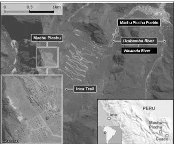
Fig. 1. Location map showing Machu Picchu and Machu Picchu Pueblo. Modified from news.bbc.co.uk.
consideration to be given to civil military cooperation not just in disaster response but in the monitoring of geohazards.
The purpose of this article is to describe a prototype early warning system designed and temporarily deployed by the GFG team in 2009 under the auspices of the World Bank. The goal here is to identify the factors that informed the sys-tem design, and to enumerate some of the key lessons learned during its installation and a subsequent four months of opera-tion. It should also be noted that the prototype was no longer in operation at the time of the recent flood, which had been foreshadowed by an extended period of unusually heavy rain. Most of the 1 million tourists who visit the Machu Pic-chu Sanctuary on an annual basis arrive by rail and make use of European-style hotels and restaurants operated by perma-nent residents of MPP or the nearby village of Santa Theresa. Thus, at any one time, there can be as many as 6000 people confined to the area immediately surrounding the conflux of three rivers in MPP. The natural beauty of the surrounding mountains had drawn the Inka leaders to Machu Picchu in the 1500’s just before the arrival of the Spanish Conquistadores. Then as now, the steep dynamic slopes posed a real and con-stant danger to any inhabitants of the valley floor. Thus, the explosive growth in tourist traffic at this World Heritage site has provided a strong impetus for early detection of geohaz-ards, and for effective emergency planning. Towards that aim, this paper describes the design and installation of a pro-totype warning system ultimately installed along the lower reaches of one of the three rivers draining through MPP. The guiding principle in its design was to obtain a robust system that could be operated, maintained, and extended in a sus-tainable fashion under local conditions.
ing peaks rise to well over 4000 m at slope gradients of up to>70◦. MPP lies at km 122 of a rail line which is linked
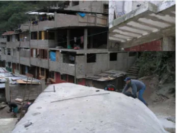
to Ollantaytambo (km 88) and ultimately Cusco (km 0) via a single narrow gauge rail track that runs along the banks of the Urubamba (or Vilcanota) River. The passenger train station in MPP serves as a rail terminus for most of the tourists who visit Machu Picchu citadel annually via a dedicated bus fleet. In recent years, the lodging capacity of MPP has grown dra-matically by a factor of three to support the demands of the tourist industry. Most of the flat low-lying ground adjacent to the Vilcanota River is now occupied by large commercial buildings (e.g., major hotels and restaurants). Here, build-ing construction reflects a general awareness of the risk of flooding with most key business activity occurring on the first floor. In contrast, most private residences and small commer-cial buildings are sited along the steeply sloping banks of the AC and the Am. Here, construction and siting practices are informal (Fig. 2), and there is a constant risk from rockfalls and other types of landslides.
The climate at MPP is subtropical, with the driest months of the winter season from May to August and the wettest months of the summer season from October to March (Fig. 3). The rainy months typically account for 80% of the annual rainfall average, which over the last two decades has averaged 1600 to 2300 mm. The average humidity is 77% during dry months and 91% during rainy months. At any given altitude, the variations in daily temperature are mod-est, and frost does not occur within the boundaries of MPP.
4 Preliminary investigation of geohazards
Fig. 2. Construction and siting practices are informal. A typical view of multistoried houses under construction. The basic plan is a concrete slab and reinforced column structure with no load bearing walls. The ground floor often contains a shop with several floors above for family use. Inset. View of a cantilevered floor showing the non uniform consistency of the concrete and the Styrofoam boards used as space fillers.
highly susceptible to disturbance. In the opinion of the au-thors, more than 70% of the inhabitants of MPP live on or just beneath meta-stable slopes, and are continually exposed to the risk of large-scale slope failure (Fig. 4).
The Aquas Calientes (AC) River runs through MPP to the Vilcanota River and has a catchment area of∼1400 hectares
(Fig. 5). During periods of intense rain, the runoff rapidly drains through and over the colluvium and/or heavily jointed bedrock that comprise the narrow steep valley sides. Histor-ical records dating to the 1940’s suggest that rockfalls, top-ples, and debris slides into the upper tributaries of the AC occur on a regular basis. On occasion, these failed materials have dammed one or more of the upper channels of the AC, temporarily reducing the flow volume in the lower channel, until such time as the accumulated water is suddenly released in a catastrophic manner as hyper-concentrated water flow, debris flow and/or mudflow. The Quechua word for this type of phenomenon is “huayco”, which is understood to describe a broad spectrum of flows either confined within or outside of normal drainage channels. At present, the last 1000 m of the AC is confined by the walls of an engineered concrete channel that bisects the western side of MPP (Fig. 6). Some portions of the channel have been periodically revised and strengthened to resist the effects of previous “huaycos”.
The mouth of the Alcamayo (Am) River lies only 200 m further upstream on the Vilcanota River from the mouth of the Aguas Calientes River. The catchment area of the Am is∼400 hectares and drains an area lying further north-east
of MPP. The last 700 m of the Am runs in a natural chan-nel cutting through an alluvial plain on the eastern side of MPP. At points where overtopping has occurred in the past
Fig. 3. Monthly TRMM 3A25(V6) data over MPP as time se-ries data from January 2000 to March 2010. Data acquired using the GES-DISC Interactive Online Visualization and analysis Infras-tructure (Giovanni) as part of the NASA’s Goddard Earth Sciences (GES) Data and Information Services Center (DISC).
Fig. 4. Quickbird image showing the AC and Am Rivers. Areas prone to rock fall, topples and slides are shown as areas with a red stipple pattern. Drainage lines for floods and debris flows are shown as areas with a red stripped pattern. Designated Safe Areas (S) are shown within green boxes. Inset A shows an area where propane tanks are stored in the open. To the immediate right of the author is a rock that fell into the rail yard in 2007. The explosion and resulting destruction resulting from a ruptured propane tank would be significant.
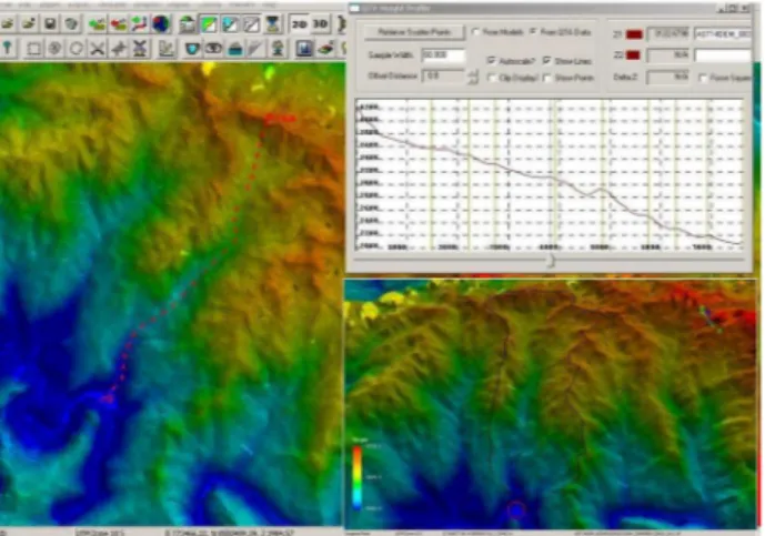
Fig. 5. Colorized DEM and ASTER Band 1 VNIR image used to examine height profile and mensuration data from the head of the Aguas Calientes watershed to MPP. The length of the Aquas Calientes River from the highest point to MPP is calculated to be 7.9 km. The channel profile is shown in the inset top right. In-set lower right shows a perspective view of the colorized DEM and ASTER Band 1 VNIR image. The black polygon shows the outline of the watersheds of the AC and Am which drain to and through MPP (shown in the red circle). Elevation is in meters.
Prior to February 2009, the early warning system in MPP was limited to observation posts located at various points 1 to 2 km upstream of MPP along the banks of the AC and Am. In practice, these posts were only manned during pe-riods of elevated risk, for example, after a marked reduction in water flow was observed following a period of unusually heavy rain. In such cases, observers were dispatched up river to their posts with instructions to immediately report any un-usual sights or sounds either via cell phone or 2-way FM radio. In practice, the GFG team observed that cell phone and 2-way FM radio communication were problematic at many locations along these steep narrow valleys. Further-more, eyewitnesses reported that “huaycos” could easily at-tain flow velocities exceeding 10 m/s and might easily reach MPP before any response to the observer’s warning could be taken. It was also unclear whether changes in flow in the lowest reaches of the AC during periods of intense rain can be reliably correlated with floodwater accumulation several kilometers higher up. The current alert system relies on the skilled judgment of a few individuals, and is prone to de-graded performance at night.
5 System configuration
The early warning system was to be wholly based on tech-nologies deemed appropriate to the local setting, which in addition to the severe physical environment also included various significant logistical and administrative constraints. From the outset, considerable attention was given to
identify-Fig. 6. Quickbird image of MPP showing the AC and Am Rivers. The square blue arrows show areas where the channel changes di-rection and overtopping has occurred historically. Note that the two “safe” areas shown in green appear to be at risk. Two rail bridges are shown as 1 and 2, upstream of which are curved blue arrows that show where a flow could back-up and overbank.
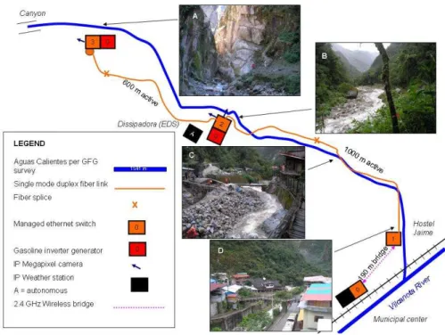
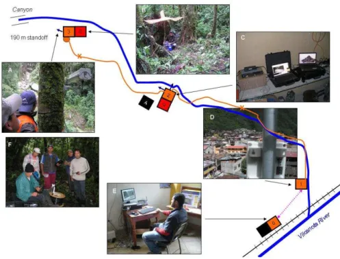
Fig. 7.Simplified plan of the prototype early warning system installed on 6 March 2009 along a 1541 m section of the Aquas Calientes River. Inset A shows a view upstream to a narrow granite walled canyon. Inset B shows a view downstream to the energy dissipation structure (EDS). Inset C shows a view on the edge of the engineered channel on the edge of the town. Inset D from the Hostel Jamie down to the confluence on the Aquas Calientes River with the Vilcanota River.
Candidate technologies from three general categories were evaluated under local conditions. These were communica-tion, sensing, and power which will now be discussed in turn.
5.1 Communication
For communication ten candidates were examined. Two sec-tors of fiber optic cable (6 mm OD, 9/125 single mode, du-plex, grade D, 500 m with 0.3 m ST terminated breakouts) were deployed up and down from the EDS, each was two 500 m links spliced inside Multilink (Starfighter #1120-F) boxes. This formed the backbone for a local area network (LAN). Once routes had been cleared in the rainforest and through cluttered urban scape of MPP, the cable was easy to deploy, splice and to check for continuity with laser light. It requires no power. Careful routing and regular inspection was essential since periodic damage was inevitable but man-ageable. Four Ethernet switches were located, one each at the canyon, EDS, Hotel Jaime and at the Municipal Center (Fig. 7). These provided two-way communication with mul-tiple IP-devices on the LAN. Each switch has eight electri-cal ports, two optielectri-cal ports and supports 1 GB per second data rate. Each port requires 2 wires or fibers and sup-ports full duplex. They were easy to deploy but required a clean dry environment and must be protected. Optical transceivers (100BASE-LX/LH SFP) were used to perform electro-optical conversion and were easy to deploy but must
Fig. 8.Communication, Sensors and Power elements in the prototype early warning system. Inset A shows an IP camera mounted up on a tree platform 190 m stand-off from the narrow granite walled canyon. Inset B shows a portable generator used to power the camera in Inset A. Inset C shows an Ethernet switch and laptop located at the energy dissipation structure. The image on the screen is the feed from a camera mounted to view the flow level. Inset D shows the wireless bridge at the Hostel Jamie to the Municipal Center. Inset E shows a computer terminal at the Municipal center with an Ethernet switch. The operator is able to view feeds from an IP camera or weather station on the LAN. Inset F shows the team of municipal workers trained to set-up and maintain the equipment in the prototype warning system.
coordinating attempts with scheduled satellite passes. The optimal site for our configuration of autonomous weather stations is higher up the watershed in the headwaters. Po-sitional information was recorded using hand-held Global Positioning System for reference to other geospatial data. When compared with georeferenced ASTER images, GPS locations were found to be poor, likely due to constraints on visible sky coverage at ground level in steep terrain with overhead rainforest canopy. At present Peru has no signal correction similar to the Wide Area Augmentation System (WAAS) available in North America.
5.2 Sensors
For sensors, eight technologies were tested. Three IP-video camera types were installed that we designated as: utility (1.3 Mega Pixel (MPx) D/N IP Camera, with internal infra-red LED illuminator ring, 3.3–12 mm lens, PoE), premium (5 MPx D/N IP Camera, with mechanical filter, 4–10 mm lens, PoE), and precision (3 MPx IP Camera, motorized 8–48 mm lens, and does not support PoE). The IP-video utility cam-era provides potential for night vision at reasonable cost but in cold wet night-time weather, the transparent viewport de-veloped a ring of localized fogging. This was resolved by mounting them in a larger heated and ventilated enclosure
(Fig. 8) but night vision was degraded. These cameras do not work in “total” darkness but can monitor illuminated fidu-cials (Bulmer et al., 2007, 2009) within an otherwise dark scene. The IP-video premium camera was three times the cost of the IP-video utility camera and produced a picture quality that was visibly superior. In low light, the daylight fil-ter retracts increasing the gain and the ability to view in faint moonlight without supplemental IR. It needed to be mounted in a heated enclosure. The IP-video precision camera was four times the cost of the utility camera, daytime vision only but permitted longer stand-offs (out to>2000 m). This was
rugged, weather resistant and stand alone. This station con-tained a rain gauge tipping bucket, a barometric pressure sen-sor, wind sensor prop vane, multiple-plate free-standing ra-diation shield enclosing a temperature and relative humidity sensor, solar regulator, datalogger, Iridium short burst mo-dem with external antenna, and a sealed 25 Amp-hr 12 v lead-acid battery. The electronics and battery were contained in a hardened plastic case with weather resistant connections of the feedthroughs for cables from external sensors. This was set-up at several locations around the EDS. All sensors were made operational and data stored in the datalogger was successfully retrieved using direct connection to a laptop and via uplink over the Iridium satellite network with data served over the internet to a dedicated web site.
5.3 Power
For power, seven candidates were examined. Upriver of MPP on the Vilcanota River, is a hydroelectric plant that supplied electricity to the town. Residents reported regular power outages. No power infrastructure extends up the AC drainage basin to the EDS though the potential exists for in-stalling 5 to 10 kW pico-hydro stations. Two gasoline gen-erators (Inverter Generator, 120 VAC, 12 DC, rated 900 W, standard 2.5 liter tank provided power for 14 h) were used outside MPP to provide power to the prototype warning sys-tem (Fig. 8). These used∼4 liters per day, required weekly oil changes and minimal maintenance over a life of∼1000 h. Methanol fuel cells and diesel generators were determined to be impractical due to altitude, special fuel needs, cost and weight. Various types of solar photovoltaics were deployed and tested but it was found that that there was insufficient light (hours×intensity) at all locations of interest. Power-over-Ethernet was provided through the design of the Ether-net switches selected and ran to all 8 ports per switch allow-ing IP-devices to be powered through RJ-45 communication cable. This eliminated the need for transformers and separate power cables. Switch mode power supplies were required for all switches, IP-sensors, computers, the wireless bridge and robotic base that were plugged into power outlets in MPP and the portable diesel generators. These proved extremely cost effective and avoided concern about power quality and voltage.
6 Improved hazard warning
The primary objective of the technology demonstration was to show that geohazard risk can be monitored continuously along the AC River. A set of suitable technology was config-ured as a working prototype with a modular design that was initially able to collect data as much as 2000 m up-river from the Municipal Center. This was demonstrated and conveyed to the community on 6 March 2009, and a local team (Fig. 8) continued to operate it on an intermittent basis until
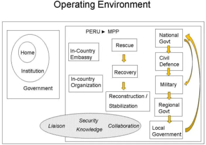
mid-Fig. 9. A schematic representation of the operating space of the GFG in working on the Machu Picchu project.
June. The secondary objective was to survey the AC River and its adjacent slopes, with sufficient accuracy to deter-mine lines-of-sight and to model channel carrying capacity. In practice, the range of useful coverage begins at the AC’s confluence with the Vilcanota and ends at the Canyon. This project proved the basic feasibility of technology-based haz-ard monitoring under local conditions (Farquhar and Bulmer, 2009). Many lessons have been identified which provide a set of concise guidelines that define a recommended approach to further development of a permanent warning system in MPP.
7 Measures of effectiveness and operating space
have chosen to-date not to act upon them. Achieving success with non experts will likely require long term engagement and that is beyond the remit given to the GFG by the World Bank.
Acknowledgements. Financial support for this project was provided
by the University of Maryland Baltimore County and The World Bank, and valuable technical services were graciously donated by Najib Roshan. In addition, GFG wishes to acknowledge the invaluable assistance of JCET and Mechanical Engineering staff at UMBC, MINCETUR and COPESCO, PeruRail, the Hotel
Inkaterra, theAlcaldeand Municipal Government of Machu Picchu
Pueblo, and many individual stakeholders. Of these, Sr. Jaime Cor-doba deserves special recognition for a selfless contribution to increased community security. The authors would also like to thank Masud Roshan, David Finnegan and CRREL, and Margarita Pajaro.
Edited by: T. Glade
Reviewed by: H. Paulsen and another anonymous referee
Bulmer, M. H. and Farquhar, T.: First Report Peru: Vilcanota Valley Slope Monitoring for Flash Flood Prevention. May 2008. Geo-physical Flow Observatory/ Landslide Mitigation Group Confi-dential Report to the World Bank, GFLO 08-05.1, 27 pp., 2008. Farquhar, T. and Bulmer, M. H.: Second Report Peru: Vilcanota