Albanian j. agric. sci. ISSN: 2218-2020, (2012), Nr. 3/Vol. 11© Agricultural University of Tirana
173
A STUDY ON AGROCLIMATIC CHARACTERIZATION OF ALBANIAN
TERRITORY
ALBERT KOPALI*, VELESIN PEÇULI, ZYDI TEQJA, ELISON ROTA
Agricultural University of Tirana, Tirana.
Coresponding author email: [email protected]
Abstract
The studies in agro-ecology, under the conditions of agricultural orientation of Albania make necessary the climate classification of agricultural areas, based on the suitability of agricultural plant groups, whose productivity level and sustainability depend on the performance and fluctuations of climatic elements. The introduction of new cultivation technologies of plants with low environmental impact requires the recognition of environmental features and in particular the climate one with the intention of satisfying the needs of each plant cultivated which is cultivated and spread in that area. To be more precise, the characterization and climatic zoning of the territory is considered to a valuable study in order to determine the most appropriate ecological zones in the country. For purposes of characterization of similar climate zones in the Albanian territory have been taken the historical series of climate data, which have been digitized and processed by applying the method "Cluster analysis" with the view to distinguishing their climate features, which will serve to distinguish the closely-related ecological areas and designing appropriate technologies for cultivation of plants based on such data.
Key words: temperature, precipitation, relative humidity, climatic zone
1. Introduction
There is no doubt that in the framework of ecological conditions, the climate is a very important part of the general environment where organisms are grown, having a great impact on them. Different climate regimes play a determinant role on the geographic and agronomic distribution of plants and on the development rate of crops also. The climate, in a considerable scale, restricts the structural characteristics and particularly the rate of plants development [1]. Regarding the climate conditions the territory of Albania, belongs to the subtropical sub belt of western coasts which is divided in two climatic zones: the Atlantic Mediterranean zone and the continental zone [2]. But the microclimatic effects created over the Albanian territory make the climate too varied. The determinant factors of climate are: country position versus general atmospheric circulation, latitude, relive configuration with a very broken orographic structure, the presence and differences between Ionian and Adriatic Sea and the orientation of mountainous masses. All these factors make it possible that in a relatively small area, wide changes of climatic elements are created resulting in a variety of zones with different climatic characteristics and with determinant impact on crops cultivation [3]. According to the climatic characteristics of agro
ecological zones and homogenous climatic zones, the agro - technologies of plant cultivation should be prepared and they should take into consideration different agricultural systems applied in these zones. The territory of our country is divided in four agro-ecological zones: Western lowland zone, Intermediate zone, South mountainous zone and North and Central mountainous zone [4], with distinct differences among them regarding the climatic conditions. The determination of climatic homogenous zones within them will help in composing more suitable technologies of crops cultivation and for their yield and sustainability levels.
2. Materials and methods
≥80% during 14 hours in 45 stations [5]. For the data groups a Cluster analysis was applied aiming the determination of similar climatic zones. “Cluster analysis” is a technique that allows creating of groups (clusters) in a way that that the elements belonging to the same group are as homogeneous as possible among them, while the elements belonging to different groups should be heterogeneous [7]. Given that the data are not hierarchical, the procedure of “fastclus” is applied according to [8]. To determine in a simple way the periods with droughts in each homogenous climatic zone the data are elaborated according to the method of ombrothermic diagrams Bagnlous & Gossen [9]. The data taken from the elaboration made to determine the homogenous climatic zones are compared with the division of agro-ecological zones trying to find similarities and differences for each zone.
3. Results and discussions
Albania is characterized by high values of precipitations which are in between of an interval from 649 mm to 1060 mm per year in lowland and hilly zones including the districts of Vlorë, Fier, Berat, Lushnjë, Durrës; that belong to the agro ecological zone of Western lowland, in South east we have the districts of Kolonjë, Korçë and Pogradec (South mountainous agro-ecological zone) [4] and in North East we have the districts of Dibra and Kukës (North and Central mountainous zone). In these zones we have similar climatic areas noted with numbers 2,6,10,11,12,13,20 and 25 (Figure 1) [10]; and maximal values included in the interval from 2295 to 3117 mm per year, mainly in South mountainous zones in the districts of Gjirokastër, Tepelenë (South mountainous agro ecological zone) and Vlorë and Sarandë (Intermediate agro ecological zone) [4]; from the North mountainous agro ecological zone here we have the districts of Puke, Tropoje e Shkoder that are in similar climatic areas and have the numbers 5 (in South) and 3 and 18 (North). We could see that in different agro-ecological zones we find similar climatic areas.
The mean annual temperatures vary between 13.9 and 17.10C in lowland and hilly zones along the coastline and between 7.5 and 10.70C, in hilly and mountainous zones in the inner part of the country. The climatic zones with higher annual mean temperatures included between 14.4 and 16.30C are marked with numbers 1,5,6,10,14,17,20,22 and 24
placed along coastline; the annual maximal mean temperature of these areas are between19.2 and 21.30C while the mean minimal temperatures are between 8.6 and 11.20C. The zones with lower annual mean temperatures included between 9.1 and 10.70C are in the mountainous South East and Northern part of the country, marked with numbers 2,3,4,13,15 and 25 belonging to the districts of Shkodra, Pukë, Kukësi, Dibra, Korça and Kolonja, the mean maximal temperatures of which are between 13.3 and 15.60C and those minimal are between 4.4 and 6.00C.
Figure 1: Homogeneous climatic zones of
Albania
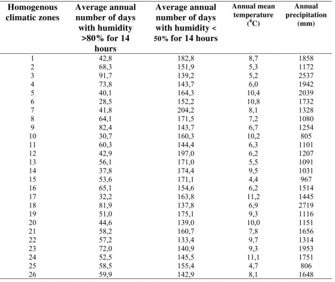
As regards the relative humidity, two variables are evaluated: monthly and annual number of days with relative air humidity >80% for at least 14 hours per day and the number of days with air relative humidity <50%. The zones with higher number of days (82-98) with air relative humidity >80% and a relatively low number of days (124-143) with humidity <50% are found in the districts of Shkodra, Tiranë, Matit, Dibra and Librazhdi; the similar climatic areas of in these zones are marked with 7,12 and 14 (Figure 1). The monthly and annual values of parameters that characterize each cluster are shown in table 1.
175
Table 1: The values of climatic parameters according to the homogenous climatic zones
Homogenous
climatic zones
Average annual
number of days
with humidity
>80% for 14
hours
Average annual
number of days
with humidity
< 50%for 14 hours
Annual mean temperature
(0C)
Annual precipitation
(mm)
1 42,8 182,8 8,7 1858
2 68,3 151,9 5,3 1172
3 91,7 139,2 5,2 2537
4 73,8 143,7 6,0 1942
5 40,1 164,3 10,4 2039
6 28,5 152,2 10,8 1732
7 41,8 204,2 8,1 1328
8 64,1 171,5 7,2 1080
9 82,4 143,7 6,7 1254
10 30,7 160,3 10,2 805
11 60,3 144,4 6,3 1101
12 42,9 197,0 6,2 1207
13 56,1 171,0 5,5 1091
14 37,8 174,4 9,5 1031
15 53,6 171,1 4,4 967
16 65,1 154,6 6,2 1514
17 32,2 163,8 11,2 1445
18 81,9 137,8 6,9 2719
19 51,0 175,1 9,3 1116
20 44,6 139,0 10,0 1151
21 58,2 160,7 7,8 1656
22 57,2 133,4 9,7 1314
23 72,0 140,9 9,3 1953
24 52,5 145,5 11,1 1751
25 58,5 155,4 4,7 806
26 59,9 142,9 8,1 1648
Drought periods in homogenous climatic zones are determined through the method of ombrothermic diagrams Bagnlous & Gossen [9]. Analyzing the data from the construction of ombrothermic diagrams it results that drought periods generally are short all over the territory of Albania and they happen during July and August. These periods are more evident in the South mountainous zone and Intermediate zone along the coastline which belong to the similar climatic zones 1, 5, 6, 7, 10, 12, 14, 17, 19 and 20.
After analyzing the data, the output regarding determination of similar climatic zones is compared with the division of agro ecological zones trying to find both differences and similarities. This will provide the possibility of differentiating the cropping technologies according to these differences.
The territory of our country is divided into four agro ecological zones: Western lowland zone, Intermediate zone, Southern mountainous zone and Northern and central mountainous zone [4]. These zones have different ecological characteristics. The Western lowland zone is placed along the coastline of
Adriatic Sea and includes the districts of Durrës, Fier, Kavajë, Laç, Kuçovë, Lezhë, Lushnjë and Peqin, with mean annual temperature 14 – 180C; during summer time in Southern zones its value is around 260C, while winter temperatures have an average of 9.80C. The northern part of this zone is a little colder with mean summer temperatures of 23.50C. The mean annual precipitations are 800 – 1200 mm and 80% of them are during the period October-March. The Northern parts are exposed to a high risk of frost during winter months [4]. From this study we can see that some districts that belong to different agro ecological zones have particular parts belonging to similar climatic zones regarding the level of precipitation, temperatures and air relative humidity.
Mallakastër, Sarandë, Shkodër, Tiranë, and Vlorë. The mean annual level 5 – 160C. The mean annual rainfall 800 – 2500 mm. Precipitation dominate during winter and generally are higher in northern and southern districts, while the districts of the central part are drier. This zone is exposed to high frequency of frost, especially during winter time [4].
Figure 2. The agro ecological zones of
Albania (Source: [4])
The South mountainous zone lies in the most part of the South part of Albania. It includes the districts: Devoll, Korçë, Kolonjë, Përmet, Pogradec, Tepelenë, and Gjirokastër. Mean annual temperature is6 – 140C, during summer time 18-200C and during winter time the average temperature is under 10 0C. Mean annual rainfall is from 600 to 1200 mm. The frosts in this zone limit the agricultural production [4].
The Northern and Central zone includes the districts: Bulqizë, Dibër, Gramsh, Has, Kukës, Librazhd, Malësi e Madhe, Mat, Mirditë, Pukë, Skrapar and Tropojë. The mean annual temperature is 3 – 12 0C. Maximal temperatures reach 250C in July, while the minimal temperatures go to –20 0C. Mean annual rainfall is from 800 to 2500 mm and they are mainly during winter time. The zone is exposed to high quantities of snow and number of frost days [4].
By comparing the data it results that in the four agro ecological zones we find similar climatic areas that provide the opportunity to prepare more suitable crop technologies with low environmental impact. In
order to have a more detailed view of the characteristics of homogenous climatic zones, an analyzes of the main components; level of rainfall, temperature and air humidity is done through the method “varimax” according to SAS/STAT [8]. From this analyzes it resulted that quantity of rainfall and temperature determine the major part of the total climatic variability (about 80 %). The quantity of precipitation is correlated positively with minimal and maximal temperatures during all months of the year and negatively with the values of relative air humidity during winter months, while temperature is correlated positively with the values of rainfall quantity during all months of a year and with the values of relative air humidity during the period April-November.
4. Conclusions
From analyzing the data of Albanian territory 26 similar climatic zones have resulted. They lie in different agro ecological zones. Similar climatic areas with lower quantity of rainfall (where the rainfall with 75% probability are from 694 to 968 mm and with 25 % probability are from 944 to 1396 mm) are marked with numbers 2, 8, 10, 11, 12, 13, 15, 19, 20 and 25 and belong to the districts of Kukës, Dibër, Pogradec, Korçë and Kolonjë of the mountainous northern and central zone; Fier, Lushnje, Durrës and Tiranë from the western lowland zone and Tepelenë, Berat and Skrapar in the intermediate zone. Similar climatic areas with higher quantity of rainfall (where the rainfall with 75% probability are from 1397 to 2099mm and with 25 % probability are from 2048 to 3214 mm) are marked with numbers 1, 3, 4, 5, 6, 18, 23, 24 and includes parts of the districts Shkodër, Tropojë and Pukë in the northern and central mountainous zone and Vlorë, Tepelenë and Gjirokastër in the intermediate and southern mountainous zone.
Similar climatic areas with high temperature (maximal absolute), hot areas, areas with mean annual temperatures from 14,4 to 16,30C, marked with numbers 1, 5, 6, 10, 14, 17, 20, 22 and 24 are those registered in July (the temperatures with 75% probability is from 32 to 33,9 0C and with 25 % probability is from 35,6 to 37,4 0C). Minimal absolute temperature with 75% probability is from -2,3 to 5,60C.
Similar climatic areas with low temperatures, cold zones with mean annual temperature from 9,1 to 10,70C marked with numbers 2, 3, 4, 13, 15, 25
177
belong to districts of Shkoder, Pukë, Kukësi, Dibër, Korçë and Kolonjë, the maximal temperature of which is from 13,3 to 15,6 0C and those minimal are frome 4,4 to 6,00C. In these areas the maximal absolute temperatures are in July and with a probability of 75% are between 27,3 and 310C and with probability 25 % are between 30,5 and 34,60C, the minimal absolute temperature in January and February with probability of 75% are between-5,9 and -7,90C, with 25% probability are between -11,6 and - 140C.Regarding the relative air humidity we have low values of relative humidity in south areas and high values in North of Albania. The drought periods generally are short all over Albania and they happen during July and August. They are more severe in southern mountainous and intermediate zones, along coastline and belong to the climatic homogenous zones 1,5,6,7,10,12,14,17,19 and 20 (Figure 1).
5. References
1. Peçuli V, Kopali A: Agroekologjia. In 2007:331 - 350.
2. Institut Hidrometeorologique –Academie des Scineces: Le climat de l’Albanie. Volume I.Precipitations atmospheriques. . Hidmet. Tirane: 1978.
3. Peçuli V, Kopali A: Ekologjia, . In 2006:275-280.
4. Shundi A: Profilet e Vendit për Burimet e Kullotave/Foragjereve – Shqipëria, FAO. 2003.
5. Institut Hidrometeorologique –Academie des Scineces.: Le climat de l’Albanie. Volume II. La temperature de l’air. . Hidmet. Tirane: 1980.
6. Institut Hidrometeorologique –Academie des Scineces.: Le climat de l’Albanie. Volume I. L’humidite de l’air. Hidmet. Tirane: 1979.
7. Hartigan JA: Clustering alogarithms. . New York.: John Wiley & Sons.; 1975.
8. Sas Institute Inc.: SAS/STAT – Guide for Personal Computers. . 1987.
9. Bagnlous F, Gossen H: Les climats bilogiques et leur classification.Ann.De Geogr. 1957:2.

![Figure 2. The agro ecological zones of Albania (Source: [4])](https://thumb-eu.123doks.com/thumbv2/123dok_br/18316280.349294/4.892.80.392.238.655/figure-agro-ecological-zones-albania-source.webp)
