Simulation of Lake Victoria Circulation
Patterns Using the Regional Ocean Modeling
System (ROMS)
Chrispine Nyamweya1,2☯*, Christopher Desjardins2☯, Sven Sigurdsson2‡,
Tumi Tomasson3‡, Anthony Taabu-Munyaho4‡, Lewis Sitoki5‡, Gunnar Stefansson2‡
1Kenya Marine and Fisheries Research Institute, Kisumu, Kenya,2School of Engineering and Natural Sciences - Faculty of Physical Sciences, University of Iceland, Reykjavik, Iceland,3United Nations
University Fisheries Training Programme, Marine Research Institute, Reykjavik, Iceland,4National Fisheries Research Institute, Jinja, Uganda,5The Technical University of Kenya, Nairobi, Kenya
☯These authors contributed equally to this work.
‡These authors also contributed equally to this work. *[email protected]
Abstract
Lake Victoria provides important ecosystem services including transport, water for domestic and industrial uses and fisheries to about 33 million inhabitants in three East African coun-tries. The lake plays an important role in modulating regional climate. Its thermodynamics and hydrodynamics are also influenced by prevailing climatic and weather conditions on diel, seasonal and annual scales. However, information on water temperature and circula-tion in the lake is limited in space and time. We use a Regional Oceanographic Model Sys-tem (ROMS) to simulate these processes from 1stJanuary 2000 to 31stDecember 2014. The model is based on real bathymetry, river runoff and atmospheric forcing data using the bulk flux algorithm. Simulations show that the water column exhibits annual cycles of thermo-stratification (September–May) and mixing (June–August). Surface water currents
take different patterns ranging from a lake-wide northward flow to gyres that vary in size and number. An under flow exists that leads to the formation of upwelling and downwelling regions. Current velocities are highest at the center of the lake and on the western inshore waters indicating enhanced water circulation in those areas. However, there is little exchange of water between the major gulfs (especially Nyanza) and the open lake, a factor that could be responsible for the different water quality reported in those regions. Findings of the present study enhance understanding of the physical processes (temperature and currents) that have an effect on diel, seasonal, and annual variations in stratification, vertical mixing, inshore—offshore exchanges and fluxes of nutrients that ultimately influence the
biotic distribution and trophic structure. For instance information on areas/timing of upwell-ing and vertical mixupwell-ing obtained from this study will help predict locations/seasons of high primary production and ultimately fisheries productivity in Lake Victoria.
OPEN ACCESS
Citation:Nyamweya C, Desjardins C, Sigurdsson S, Tomasson T, Taabu-Munyaho A, Sitoki L, et al. (2016) Simulation of Lake Victoria Circulation Patterns Using the Regional Ocean Modeling System (ROMS). PLoS ONE 11(3): e0151272. doi:10.1371/journal. pone.0151272
Editor:Shang-Ping Xie, University of California San Diego, UNITED STATES
Received:June 29, 2015
Accepted:February 25, 2016
Published:March 31, 2016
Copyright:© 2016 Nyamweya et al. This is an open access article distributed under the terms of the
Creative Commons Attribution License, which permits unrestricted use, distribution, and reproduction in any medium, provided the original author and source are credited.
Data Availability Statement:All data files are available from the FigShare database. The DOI is10. 6084/m9.figshare.2075479.
Funding:This work was supported by the United Nations University - Fisheries Training Program (UNU-FTP) PhD scholarship to CN. The funders had no role in study design, data collection and analysis, decision to publish, or preparation of the manuscript.
Introduction
Lake Victoria is thought to have formed about 400,000 years ago by down-warping of land between the two arms of the Great Rift Valley. Westward-flowing rivers were dammed by an upthrown crustal block, reversing their flow into the down warped land. During its geological history the lake topography went through changes ranging from its present shallow depression, to what may have been a series of much smaller swampy lakes that gradually became intercon-nected, lost their outlet to the west and were drained northwards by the Nile [1]. Geological cores taken from bottom sediments show that Lake Victoria has dried up completely at least three times since it formed [2]. Measured by surface area (68,000 km2), it is the largest fresh water lake in the tropics and second in the world. However, due to its shallowness, it is the 17th largest among the world lakes by volume [2]. The lake is shared among Kenya (6%), Uganda (43%) and Tanzania (51%). The catchment is about 193,000 km2extending to Rwanda and Burundi. About 33 million inhabitants in the basin within the three East African countries depend on the lake for transport, water for domestic and industrial uses and fisheries [3].
The lake plays an important role in modulating regional climate. Its thermodynamics and hydrodynamics are also influenced by climatic factors such as the Intertropical Convergence Zone (ITCZ), El Nino/Southern Oscillation (ENSO), complex orographic forcing, and the Indian Ocean zonal temperature gradient anomalies [4,5] on diel, seasonal and annual scales [6]. The ITCZ that separates the northeast and southeast monsoons, crosses East Africa twice every year, once during March-April-May and again during October-November-December. This incursion and retreat of the ITCZ is responsible for the two main rainfall and dry seasons of the region. The rainy season from March through to May is commonly known as the‘long rains’; the second rainy season of October through to December is called the‘short rains’[7]. The water budget is controlled mainly through precipitation over the lake surface, catchment inflow, controlled outflow at a hydroelectric dam on River Nile and evaporation [2,8,9]. The lake does have a season of deep vertical mixing when the lake becomes isothermal. During June and July the established thermocline breaks down under the seasonal onset of the south-east trade winds and for a brief period at the end of July the main body of the lake becomes isother-mal with respect to depth. The thermocline most often occurs at 30–40 m depth. Complete mixing occurs once a year [10].
Lake Victoria is not physico-chemically homogenous. Much of the shoreline in the north and south is highly irregular. The northern shallow waters are intercepted by numerous islands. East and west of the lake, the basin rises over a thousand meters to highlands bordering the respective rift valleys, but to the north and south the watershed is less than 25 m above lake level [2]. Water quality varies spatially in Lake Victoria. Gulfs, near-shore areas adjacent to big human settlements and river mouth areas are relatively turbid and eutrophic [11]. The diverse topography/terrain, prevailing weather/climatic conditions as well as river inflows and out-flows influence water circulation patterns. This in turn determines the temporal-spatial water quality which can be linked to the distribution of biota in the lake [11].
Previous hydrographic studies have explored water movements on a small scale either in space or time. Anyah and Semazzi (2009) [4] developed an idealized simulation of hydrody-namic characteristics of Lake Victoria. The authors relied on idealized (and real) bathymetry and uniform surface wind stress over a period of sixty days. MacIntyre (2014) [6] studied thermo-stratification and factors affecting horizontal exchange while Okely (2010) [11] evalu-ated processes affecting horizontal mixing and dispersion in the Nyanza Gulf of Lake Victoria. To better understand annual and seasonal water circulation (currents) in Lake Victoria, a Regional Oceanographic Model System (ROMS) is developed. The model is based on real bathymetry, wind stress, surface heat fluxes, solar radiation and river inflow/outflow forcing.
The ROMS includes accurate and efficient physical and numerical algorithms and several cou-pled models. It also includes several vertical mixing schemes [12], multiple levels of nesting and composed grids.
Materials and Methods
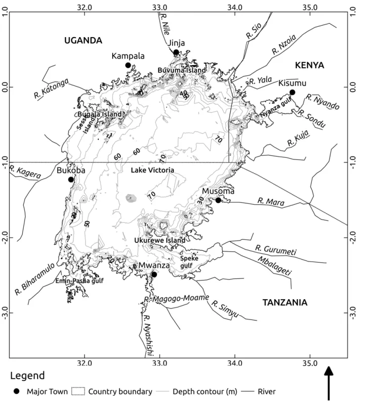
The Lake Victoria ROMS model extends from 31.5°—34.88° E and 3.05° S to 0.55° N (Fig 1). It has a horizontal grid resolution of 1.9 km. The total number of grid points is 209 and 216 in the longitudinal and latitudinal directions respectively. The fine grid resolution is chosen to adequately resolve processes within narrow gulfs, bays and indented coastlines. The model has 20 terrain-following vertical levels with a minimum depth set to 5 m. Preliminary model runs with fewer vertical levels did not realistically mimic observed temperature profiles failing to accurately predict the thermocline depth as result of averaging values over wide depth ranges. The model has surface stretching factorθs= 3 to maintain high resolution throughout surface
layers of the model domain.θ
bis set to 1 to allow the influence of bathymetry on overlying
lay-ers. Here,θis a refinement parameter that determines the magnitude of stretching of the
verti-cal grid in either the surface (θ
s) or bottom layers (θb). The thermal expansion coefficient and
background density values are estimated for fresh water at 24°C. A typical linear bottom drag coefficient [13,14] is applied for the entire computation domain given the small depth range of the lake. Other model parameters are described inTable 1
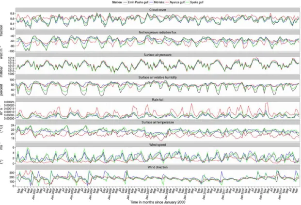
The bathymetry/topography (Fig 1) is derived from lake wide hydro-acoustic survey data. Meteorological surface forcing data are obtained from the European Centre for Medium-Range Weather Forecasts (ECMWF) ERA Interim, daily data set extracted at 3 hour time steps with 0.125° horizontal resolution from 1stJanuary 2000 to 31stDecember 2014. Cloud cover, net longwave radiation flux, surface air pressure, surface air relative humidity, rain fall, surface air temperature, Surface v- and u-wind components 10 meters above the water surface and river runoff forcing fields (Fig 2) are implemented using the bulk flux algorithm [15]. The model is initialized with a uniform temperature of 24°C and no momentum on 1stJanuary 2000. Salinity is set to zero. Simulated spatial-temporal temperature trends are fitted to obser-vation data collected during the 2000–2001 and 2005–2014 lake wide hydro-acoustic surveys. Modeled (^y) and observed (y) vertical temperature profiles are compared using the Root Mean Squared Error (RMSE).
RMSE¼
ffiffiffiffiffiffiffiffiffiffiffiffiffiffiffiffiffiffiffiffiffiffiffiffiffiffiffiffiffi 1
n Xn
i¼1
ðyi ^yiÞ
2 s
ð1Þ
Results
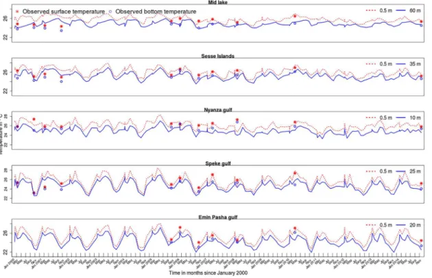
Results from the Lake Victoria ROMS model show spatial and temporal variations in water temperature. Modeled temperatures largely agree with observations (Fig 3) except at the begin-ning of the model run in the deeper stations.Table 2shows simulated temperature statistics at 5 selected sites. Mean temperatures are similar in all the stations. However, fluctuations are more pronounced in Emin Pasha and Speke gulfs located on the southern shores of the lake. In the middle of the lake which is relatively deeper, there is less variability in temperature (Fig 3).
in the months of August and October in the surface and bottom layers respectively. Thereafter the temperature steadily rises before taking a downward turn in March and May for the surface and bottom layers respectively. The two month lag in either warming or cooling of the bottom layers leads to stratification when the two processes are out of sync.Fig 4shows modeled and Fig 1. Map of Lake Victoria, its major rivers and bathymetry.
doi:10.1371/journal.pone.0151272.g001
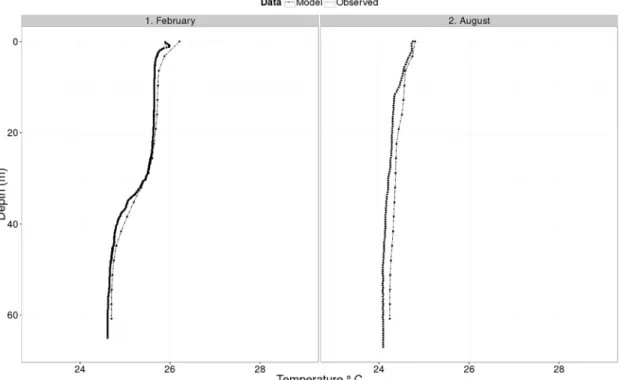
observed vertical temperature profiles in the middle of the lake during the months of February (stratified) and August (isothermal) 2008. Differences in RMSE values between modeled and observed temperature profiles are 0.73 and 0.22 in February and August respectively, and gen-erally the modeled temperature closely matches the observed profile.
Figs5–6show temperature and water circulation patterns (currents) at 0.5 m and 35 m depths respectively in different months of 2008. The modeled circulation at the surface follows Table 1. Basic model configuration.
Parmeter Value Description
Lm 209 number of points in longitude direction
Mm 216 number of points in latitude direction
N 20 number of vertical (sigma) levels
hmax 80 m maximum depth of the domain
hmin 5 m minimum depth of the domain
θs 3 sigma coordinate surface stretching factor
θb 1 sigma coordinate bottom stretching factor
Δt 60 s baroclinic time-step
Δtf 20 s barotropic time step
r 3.0 10−4m2s−1 linear bottom drag coefficient
Tcoef 2.4725 10−4 Thermal expansion coefficient
ρ 997 kgm−3 Background density value
doi:10.1371/journal.pone.0151272.t001
Fig 2. Evolution of different model forcing variables: cloud cover, net longwave radiation, surface air pressure, surface air relative humidity, rainfall, surface air temperature, wind speed and direction at selected locations in Lake Victoria from the year 2000–2014.
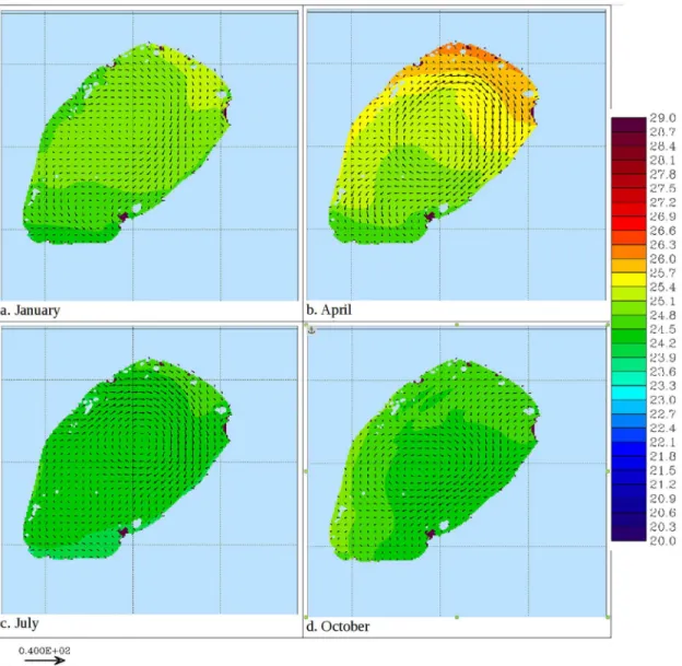
the general pattern of the wind curl depicted inFig 7. In January, 20 day average surface tem-peratures are generally uniform throughout the lake with the exception of Nyanza Gulf. Surface currents generally flow northwards in most of the open lake (Fig 5a). In April, surface tempera-tures are higher in the northern near-shore areas relative to the rest of the lake. During this period, surface currents flow in a gyre formation whose center is drawn towards the warmer regions in the north (Fig 5b). Surface temperatures are generally lowest in July and August. This is especially so in the south. As the surface temperature decreases, the gyre circulation dis-appears and the currents flow northwards (Fig 5c). The temperatures are highest in the month of October, with the western and northern shorelines being relatively warmer than the rest of the lake. A gyre circulation pattern is also evident during this period, and like in April, its cen-ter is drawn towards the warmer region (Fig 5d).
At 35 meters depth, the trend is similar to the surface except that the temperatures are a bit lower and they hit their lowest levels two months later than at the surface. Water circulation takes on various patterns at different times of the year (results not shown). Largely it is a one gyre pattern but two or more gyres are manifest at different times of the year.Fig 6cshows two Fig 3. Modeled and observed surface and bottom temperature trends at selected sites in Lake Victoria.
doi:10.1371/journal.pone.0151272.g003
Table 2. Temperature (°C) variations at selected sites in Lake Victoria.
Station Mean±sd Maximum Minimum
Emin Pasha gulf 24.79±1.26 28.18 21.93
Mid lake 25.26±0.63 27.45 23.75
Nyanza Gulf 25.24±0.79 28.33 23.25
Sesse islands 25.53±0.79 28.00 23.41
Speke Gulf 25.16±1.16 28.50 21.89
doi:10.1371/journal.pone.0151272.t002
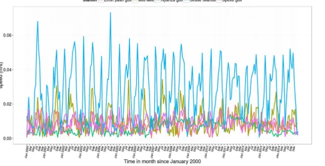
gyre currents at a depth of 35 meters. Gyres are more pronounced in two dimensional (depth averaged) currents (Fig 8). Current velocities are higher in April and July around the gyre for-mation, especially so in the northern part near Sesse Islands (Fig 9). High current velocities also prevail in the middle of the Lake. However relatively slow flow rates are observed within the three major gulfs of Lake Victoria.
As expected, model results indicate that vertical water velocities are higher during the iso-thermal period as compared to the stratified period (Fig 10) in both west-east and south-north cross sections. In the stratified period, when vertical velocities are lower, there seems to be min-imal exchange of water across the thermocline. On the other hand there is water circulation throughout the water column in the mixed season. During the stratified period there appears to be downwelling at the western and eastern ends of the lake with minimal upwelling above the thermocline at the center of the lake. Generally there is net upward water circulation in the south and some downwelling in the north. During the mixed (isothermal) period, there is upward and downward movement of water in the east and west respectively (Fig 10a). Similarly there is upwelling in the south and downwelling in the north (Fig 10b).
Discussion
The present study used ROMS to simulate water temperature and circulation patterns in Lake Victoria. Model results are compared to available spatial-temporal temperature data collected during the 2000–2001 and 2005–2014 lake-wide hydro-acoustic surveys. Modeled temperature trends both at the surface and the bottom fit well to observation data. This is especially so for data collected during the 2005–2014 surveys. At the beginning of the simulation (2000–2001), predic-tions deviate from data points because of the spin-up time the model requires to reach a state of equilibrium under the applied forcing. This is more pronounced in the deeper regions that Fig 4. Observed and modeled vertical temperature profiles in Lake Victoria during the months of February and August 2008.
require a longer spin-up time. Comparison of simulated and observed vertical temperature pro-files in the middle of the lake are also presented with RMSE showing minimal inconsistencies between the two profiles. Additional model validation is derived from the general conformity of surface water currents and wind curl fields. Results show that the water column is thermally strat-ified most of the time, only experiencing complete vertical mixing once a year during the months of June to July. Isothermal conditions last up to August in some years. The seasonal changes in water column temperature profiles coincide with those observed in other studies conducted in Lake Victoria [6,16–18]. The ability of ROMS to mimic seasonal changes in surface and vertical water temperature profiles confirm the reliability of the simulations. It therefore presents a unique opportunity of exploring other physical processes, mainly water circulation patterns, in Lake Vic-toria. Water circulation is important in influencing water quality, distribution of nutrients, move-ment of plankton biota and ultimately influences other ecosystem dynamics [5].
Thermal stratification occurrs when surface waters warm up faster than the underlying lay-ers. This leads to the formation of a thermocline across which there is little exchange of water. Breakdown of the thermocline can be attributed to a number of factors. As the surface waters start to cool down, the lake becomes isothermal and stratification breaks down. Changes in sur-face temperatures correspond well with fluctuations in solar radiation implying that the latter Fig 5. Modeled 20 day averaged near surface (5 m) temperature (shaded) and currents (vectors) in Lake Victoria in different seasons of 2008.
doi:10.1371/journal.pone.0151272.g005
plays a crucial role in stratification and mixing of the water column of Lake Victoria. The long rains of March through May could also play a role in reducing surface temperature given that precipitation accounts for up to 80 percent of the lake’s water inputs. Currents resulting from increased wind stress accelerate the process of vertical mixing and the eventual breakdown of the thermocline, an observation also made by MacIntyre (2014) [6].
Currents take several forms throughout the year. When water temperatures at the surface are nearly uniform spatially, a general northward flow is sustained in the open lake. This pat-tern has also been reported in Lake Victoria by MacIntyre (2014) [6]. However, when surface waters in some regions are warmer, gyres prevail. Gyres range from a single one, that engulfs most of the lake and generally flows clockwise at the surface, to two that spin in opposite direc-tions. Sometimes several short-lived small gyres drive water circulation in the lake. Anyah (2009) [4] also reported gyre formation in Lake Victoria. Deeper water masses exhibit a counter flow to surface water layers. Counter currents occur at the fringes of gyres. A Fig 6. Modeled 20 day averaged temperature (shaded) and currents (vectors) at 35 m in Lake Victoria in different seasons of 2008.
consequence of this, is the formation of upwelling and downwelling regions that shift spatially due to the changing of circulation patterns. Upwelling causes a motion of dense, cooler, nutri-ent-rich water towards the surface, replacing the warmer, nutrient-depleted surface water. The nutrient-rich upwelled water stimulates the growth and reproduction of primary producers (phytoplankton). Knowledge of the location and timing of upwelling obtained from this study will help predict presence of high levels of primary productivity and thus fishery production in Lake Victoria. MacIntyre (2014) [6] observed that upwelling occurs on the basin scale in response to increased southerly winds over Lake Victoria. Vertical velocities in both the west-Fig 7. Modeled 20 day averaged wind curl (vectors) in Lake Victoria in different seasons of 2008.
doi:10.1371/journal.pone.0151272.g007
east and south-north cross-sections depict the influence of stratification on water circulation. The velocities are minimal during the stratified period and water movements are limited to either side of the thermocline. Lack of exchange of water between surface and bottom layers explain the development of anoxic conditions in the latter that are prevalent during the strati-fied period [6,10].
Water circulation patterns in the three gulfs (Nyanza, Speke, and Emin Pasha) are localized. They are characterized by relatively slow water current velocities, probably because they are sheltered and shallow (especially Nyanza which is connected to the main lake via a narrow channel). This could inhibit water exchange between the gulfs and the open lake. The gulfs Fig 8. Modeled 20 day verically averaged currents (vectors) in Lake Victoria in different seasons of 2008.
coincidentally host major river mouths and large urban settlements through which nutrients, sediments and pollutants enter the lake. Due to the little flushing with water from the lake, these regions are limnologically different from the open lake and are particularly more turbid and eutrophic.
Circulation in Lake Victoria is mainly driven by differential heat fluxes, wind stress and bot-tom terrain. Spatial variability in latent heat fluxes creates conditions conducive for horizontal convective circulation [10,19]. The difference in water density as a result of temperature varia-tions causes gravity currents at the surface [20].
Conclusion
Information on water temperature and circulation patterns in Lake Victoria has been limited prior to this study. Reliability of the generated model is reinforced by its ability to fit to obser-vational spatial-temporal temperatures trends as well as replicating vertical temperature pro-files in the lake during both mixed and stratified periods. Simulated data show that the water column exhibits annual cycles of thermal stratification (September–May) and mixing (June–
August). Vertical velocities are low during the stratified period and are localized to either side of the thermocline. This explains the low oxygen levels that occur in deep waters during the stratified period.
Surface water currents in Lake Victoria take on different patterns ranging from a lake-wide northward flow to gyres that vary in size and number. An underflow is a constituent of the circu-lation leading to the formation of upwelling regions that shift in time and space. Current velocities are highest at the center of the lake and also in the western inshore waters indicating enhanced water circulation in those areas. On the contrary, there seems to be little exchange of water between the major gulfs (especially Nyanza) and the open lake, a factor that could be responsible for the different water quality reported in those regions [6]. Information on the location and tim-ing of upwelltim-ing and vertical mixtim-ing obtained from this study will help predict presence and loca-tion of high levels of primary productivity and thus fishery producloca-tion in Lake Victoria.
Fig 9. Modeled 20 day currents velocities from the year 2000–2014 at selected sites in Lake Victoria.
doi:10.1371/journal.pone.0151272.g009
Temporal and spatial differences in both water temperature and circulation (currents), are attributable to a range of atmospheric forcing effects and lake terrain. Findings of the present study enhance our understanding of the physical processes of the Lake Victoria and conse-quently form a basis for future comprehensive ecosystem studies that quite often require physi-cal hydrodynamic components. The developed model also forms a basis for which future observations could be made to refute or corroborate findings of this study.
Supporting Information
S1 Files. Shape files for a map of Lake Victoria in East Africa, its major rivers and bathymetry. (ZIP)
Acknowledgments
This work was supported by the United Nations University -Fisheries Training Program (UNU-FTP) in Reykjavik Doctoral Fellowship to CN. Longterm model simulations were run on the Marine Research Institute (Iceland) supercomputer.
Fig 10. The modeled daily averaged water temperature (shaded, in °C) and vertical velocity (contour, in cm/day and positive upward) in Lake Victoria in stratified (upper row) and isothermal (lower row) conditions in 2008.The west—east section (left) is along 1.0°S while the south—north section (right) is along 33.2°E.
Author Contributions
Conceived and designed the experiments: CN CD SS GS. Performed the experiments: CN. Analyzed the data: CN CD. Contributed reagents/materials/analysis tools: ATM LS. Wrote the paper: CN TT ATM LS GS.
References
1. Temple PH. Some biological implications of a revised geological history for Lake Victoria. Biological Journal of the Linnean Society. 1969; 1(December):363–371. doi:10.1111/j.1095-8312.1969.tb00126.
x
2. Kendall RL. An ecological history of the Lake Victoria Basin. Ecological Monographs. 1969; 39(2):121–
176. doi:10.2307/1950740
3. Crul RCM. Limnology and Hydrology of Lake Victoria. Paris: UNESCO Publishing; 1995.
4. Anyah RO, Semazzi F. Idealized simulation of hydrodynamic characteristics of Lake Victoria that poten-tially modulate regional climate. International Journal of Climatology. 2009; 29:971–981. doi:10.1002/ joc.1795
5. Sun X, Xie L, Semazzi FHM, Liu B. A numerical investigation of the precipitation over Lake Victoria Basin using a coupled Atmosphere-Lake Limited-Area Model. 2014.
6. MacIntyre S, Romero JR, Silsbe GM, Emery BM. Stratification and horizontal exchange in Lake Victo-ria, East Africa. Limnology and Oceanography. 2014; 59(6):1805–1838. doi:10.4319/lo.2014.59.6.
1805
7. Song Y, Semazzi FHM, Xie L, Ogallo LJ. A coupled regional climate model for the Lake Victoria Basin of East Africa. International Journal of Climatology. 2004; 24:57–75. doi:10.1002/joc.983
8. Swenson S, Wahr J. Monitoring the water balance of Lake Victoria, East Africa, from space. Journal of Hydrology. 2009; 370(1–4):163–176. Available from:http://dx.doi.org/10.1016/j.jhydrol.2009.03.008.
doi:10.1016/j.jhydrol.2009.03.008
9. Tate E, Sutcliffe J, Conway D, Farquharson F. Water balance of Lake Victoria: update to 2000 and cli-mate change modelling to 2100. Hydrological Sciences Journal. 2004; 49(August 2004):563–574. Available from:http://www.tandfonline.com/doi/abs/10.1623/hysj.49.4.563.54422.
10. Talling JF. The annual cycle of stratification and phytoplankton growth in Lake Victoria (East Africa). Internalionale Revue Gesamte Hydrobiologia. 1966; 51:545–621. doi:10.1002/iroh.19660510402
11. Okely P, Imberger J, Antenucci J. Processes affecting horizontal mixing and dispersion in Winam Gulf, Lake Victoria. Limnology and Oceanography. 2010; 55:1865–1880. doi:10.4319/lo.2010.55.5.1865
12. Warner JC, Sherwood CR, Arango HG, Signell RP. Performance of four turbulence closure models implemented using a generic length scale method. Ocean Modelling. 2005; 8:81–113. doi:10.1016/j. ocemod.2003.12.003
13. Rocha C, Cordeiro N, Nolasco R, Dubert J. Numerical modelling of the phytoplankton patterns in an upwelling event off the NW Iberian Margin. In: Journal of Coastal Research. SPEC. ISSUE: 65; 2013. p. 117–122. Available from:http://www.scopus.com/inward/record.url?eid=2-s2. doi: 10.2112/SI65-021a.1
14. Taylor JR, Sarkar S. Stratification Effects in a Bottom Ekman Layer. Journal of Physical Oceanography. 2008; 38(11):2535–2555. Available from:http://journals.ametsoc.org/doi/abs/10.1175/2008JPO3942. 1. doi:10.1175/2008JPO3942.1
15. Fairall CW, Bradley EF, Hare JE, Grachev AA, Edson JB. Bulk parameterization of air-sea fluxes: Updates and verification for the COARE algorithm. Journal of Climate. 2003; 16(4):571–591. doi:10. 1175/1520-0442(2003)016%3C0571:BPOASF%3E2.0.CO;2
16. Talling JF. The photosynthetic activity of phytoplankton in East African lakes. International Review of Hydrobiology. 1965; 50:1–32. doi:10.1002/iroh.19650500102
17. Sitoki L, Gichuki J, Ezekiel, Wanda CF, Mkumbo C, Marshall B. The environment of Lake Victoria (East Africa): Current status and historical changes. Research Paper. International Review of Hydrobiology. 2010; 95:209–223. doi:10.1002/iroh.201011226
18. Taabu-Munyaho A, Kayanda RJ, Everson I, Grabowski TB, Marteinsdóttir G. Distribution and exploita-tion of Nile perch Lates niloticus in relaexploita-tion to stratificaexploita-tion in Lake Victoria, East Africa. Journal of Great Lakes Research. 2013 sep; 39(3):466–475. Available from:http://linkinghub.elsevier.com/retrieve/pii/ S0380133013000816. doi:10.1016/j.jglr.2013.06.009
19. Talling JF. The incidence of vertical mixing, and some biological and chemical consequences, in tropi-cal African lakes. Internationale Vereinigung für Theoretische und Angewandte Limnologie. 1969; 17:998–1012.