1Independent consultant. E-mail: [email protected] 2Independent consultant. E-mail: [email protected] *Corresponding author.
Manuscript ID 20170114. Received in: 08/25/2017. Approved in: 09/01/2017
ABSTRACT: Greenstone belts with deposits of gold, iron and man-ganese are common in the Paleoproterozoic Maroni-Itacaiunas Tec-tonic Province of the Guiana Shield. In Brazil, in the State of Amapá and northwest of Pará, they are represented by the Vila Nova Group, constituted by a basal unit of metabasalts, covered by metasediments of clastic and chemical origin. he basal metasediments, the Serra do Navio Formation, are made of a cyclothem with lenses of manganese marbles at the top of each cycle. Under the intense weathering of the Amazon, these lenses were oxidized to large deposits of high-grade manganese oxides. he exploitation of these oxides left behind the manganese carbonates and low-grade oxides. he overlaying Serra da Canga Formation presents a calcium and magnesium domain grad-ing to an iron domain with banded silicate and oxide iron formations, mined for iron ores. Overlapping structures and superposed phic crystallizations indicate two phases of dynamothermal metamor-phism, the irst one with axis to north-northeast and the second one to northwest, with an intermediate phase of thermal metamorphism related to syntectonic granitic intrusions. Shears oriented north-south, possibly formed during the irst dynamothermal metamorphism and reactivated in the second, are ideal sites for hydrothermalism and gold mineralization, which is greater when occurs in iron formation and carbonate-bearing rocks, as it happened at the Tucano mine. Layered maic-ultramaic intrusions in the greenstones represent a potential for chromite and platinum group elements. Pegmatites are source of cas-siterite and tantalite exploited from alluvial deposits.
KEYWORDS: Group Vila Nova greenstones; Manganesiferous Precambrian cyclothem; Precambrian iron formation; Precambrian maic-ultramaic complexes; Superposed metamorphic cycles.
RESUMO: A Província Tectônica Paleoproterozoica Maroni-Ita-caiunas estende-se ao longo de toda a área costeira do Escudo das Guianas apresentando nessa extensão faixas de greenstone com depó-sitos hidrotermais de ouro. No Brasil, no estado do Amapá e no noro-este do Pará, os greenstones são representados pelo Grupo Vila Nova, que também apresenta depósitos sedimentares de ferro e de manganês e intrusões de complexos máico-ultramáicos com possibilidades de mineralizações de cromo e platinoides. Pegmatitos com cassiterita e tantalita são relacionados a intrusões graníticas sintectônicas nos gre-enstones. As faixas de greenstone Vila Nova cobrem embasamento de gnaisses, migmatitos e granitos. Em sua base há unidade de ortoani-bolitos, capeada por metassedimentos químicos e clásticos de granula-ção ina, na base dos quais há um ciclotema com lentes de mármore manganesífero no topo de cada ciclo. Na intemperização essas len-tes foram substituídas por corpos massivos e de altos teores de óxido de manganês. As subsequentes unidades da coluna metassedimentar apresentam inicialmente domínio de cálcio e magnésio, gradando acima para um domínio de ferro, caracterizado por formações ferrífe-ras silicáticas e óxidas, parte das quais são lavradas para minério de ferro. Corpos graníticos sintectônicos são intrusivos e formam domos no greenstone. Os greenstones foram submetidos a duas fases de meta-morismo dinamotermal, com uma fase intermediária de metamoris-mo termal causada pelos granitos intrusivos. Zonas de cisalhamento formadas na primeira fase de metamorismo e reativadas na segunda constituem locais favoráveis para a mineralização aurífera, principal-mente quando em formações ferríferas.
PALAVRAS-CHAVE: Greenstones do Grupo Vila Nova; Ciclotema manganesífero Precambriano; Formação ferrífera Precambriana; Comple-xos máico-ultramáicos Precambrianos; Ciclos metamóricos superpostos.
Gold, iron and manganese
in central Amapá, Brazil
Ouro, ferro e manganês na área central do Amapá, Brasil
Wilson Scarpelli1*, Élio Hiromi Horikava2
INTRODUCTION
he objective of the authors is to divulge geological knowledge acquired throughout the years in exploration activities for deposits of iron, gold and manganese in the State of Amapá, Brazil, on behalf of Indústria e Comércio de Minérios S.A. (ICOMI), Unigeo Geologia e Mineração, Minorco Brasil, Anglo American do Brasil, AngloGold Ashanti, Min. Pedra Branca do Amapari, MMX Mineração, and others. It is expected that this note will help to under-stand the geology and mineral potential of the area and be useful in forthcoming mineral exploration there and elsewhere.
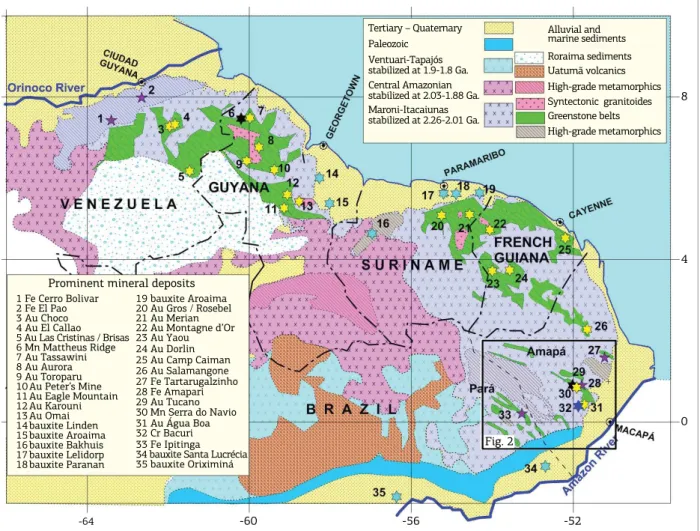
he described deposits occur in the Brazilian part of the Precambrian Guiana Shield (Fig. 1), which is constituted by four laterally collated tectonic provinces (Cordani & Teixeira 2007, Cordani et al. 2016), all of them containing Archean rocks metamorphosed into granitoids (gneisses, migmatites and intrusive granitic rocks), also presenting intrusive, vol-canic, metamorphic and sedimentary units of variable ages.
At east, next to the coast, the Maroni-Itacaiunas (MI) Province is mostly made of Archean and Paleoproterozoic granitoids, also presenting belts of greenstone and associ-ated intrusives, granulites, archean nuclei (Rosa-Costa et al. 2006), blocks of high metamorphic-grade rocks and granu-lites. he province was subject to several phases of tectonism and metamorphism, being tectonically stabilized at 2.26 to 2.01 Ga. From Venezuela to the Amazon Valley, the green-stones are remarkable for their mineral deposits of gold, iron and manganese, plus tantalum and tin in pegmatites. In Brazil, the province also contains stratiform deposits of chromite in intrusive layered maic-ultramaic complexes (Spier & Ferreira Filho 2001).
Adjacent to the southwest, the Central Amazonian Province, stabilized at 2.03 to 1.88 Ga., contains several nuclei of Archean ages surrounded by Paleoproterozoic rocks and in the Middle Proterozoic received a large load of acid intrusives and extrusives in the south and of clastic sediments in the north. Next to west, the Ventuari-Tapajós Province, stabilized at 1.9 to 1.8 Ga., is composed by stacked
Figure 1. Tectonic Provinces of the Guiana Shield, as presented by the Tectonic Map of South America (Cordani et al. 2016), and their main mineral deposits.
Tertiary – Quaternary Paleozoic
Ventuari-Tapajós stabilized at 1.9-1.8 Ga. Central Amazonian stabilized at 2.03-1.88 Ga. Maroni-Itacaiunas stabilized at 2.26-2.01 Ga.
Alluvial and marine sediments
8
4
0
-64 -60 -56 -52
Roraima sediments Uatumã volcanics High-grade metamorphics Syntectonic granitoides Greenstone belts High-grade metamorphics
Fig. 2 Prominent mineral deposits
1 Fe Cerro Bolivar 2 Fe El Pao 3 Au Choco 4 Au El Callao 5 Au Las Cristinas / Brisas 6 Mn Mattheus Ridge 7 Au Tassawini 8 Au Aurora 9 Au Toroparu 10 Au Peter’s Mine 11 Au Eagle Mountain 12 Au Karouni 13 Au Omai 14 bauxite Linden 15 bauxite Aroaima 16 bauxite Bakhuis 17 bauxite Lelidorp 18 bauxite Paranan
marginal arcs, sediments and intrusives. Further west, com-pleting the shield, the Rio Negro-Juruena Province is made of volcano-sedimentary sequences and intrusives related to rift structures and platform sedimentation, altogether sta-bilized at 1.8 to 1.6 Ga.
his work relates to the Brazilian part of the MI Province north of the Amazon River, in the states of Amapá and Pará. he greenstone belts of this portion of the province, com-posed by lithologies of the Vila Nova Group, were studied in detail where they host valuable deposits of manganese, iron and gold. Outside of these areas, the deep weathering and lack of outcrops make their study quite diicult.
he name came from the Vila Nova River, site of the irst discovery of iron ore in the state of Amapá, in the 1940s. Since then, the exploration of the belts by mine companies were directed essentially to manganese and iron, with indi-vidual miners (garimpeiros) exploring for gold, cassiterite and tantalite. It was only at about the 1980s that some mine companies started to develop an interest for gold.
Where studied in detail, the Vila Nova Group was seen constituted by metamorphosed volcanic and sedi-mentary rocks, presenting iron formation in the sequence.
The basement for the greenstones is made of gneisses, migmatites and intrusive granites, granodiorites, and a few diorites. he scarcity of outcrops, allied to the present lack of economic attractivity of these rocks, leaves them poorly investigated. heir characterization is made mostly from out-crops along river valleys, supported by aerial imagery and aerogeophysical data. Geochronological studies observed a mix of Archean to Paleoproterozoic ages, with some of the Paleoproterozoic rocks representing reworking of Archean protoliths.
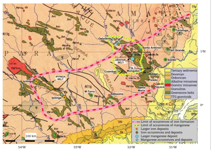
Intensive campaigns of regional geological reconnais-sance done by ICOMI and other mine companies, look-ing for manganese and iron formation, revealed the extent of occurrences of manganese oxides and iron formation in the greenstone belts of the MI Province, which is shown in Figure 2. Indeed, they do not occur at random, but are quite limited to well outlined areas and belts, what gives a hint of the extent and continuity of the environments of their deposition. he occurrences of iron formation appear in a 350 kilometers long and 100 kilometers wide belt oriented to northeast, and still open to northeast, to the coast. he good deinition of this belt seems to represent
Figure 2. Depository areas of manganese and iron-rich sediments of the Vila Nova Group greenstones in the States of Pará and Amapá, outlined over the Geologic Map of Brazil at 1:2,500,000 (Schobbenhaus et al. 2001).
54ºW 53ºW 52ºW 51ºW
1ºN
0º Tertiary sediments Devonian
Greenstone belts TTG granitoids Ordovician Alkaline intrusives Granitic intrusives Granulites
Limit of occurrences of iron formation Limit of occurrences of manganese Larger iron deposits
the depository area of the iron formations. By their side, the occurrences of manganese cluster at about Serra do Navio, at the center-north of the iron-bearing belt, in a situation which possibly indicates the center of the initial deposition of the sediments of the Vila Nova Group.
The greater greenstone belt of the area, the Amapari, at right of center of Figure 2, contains the larger known depos-its of manganese, gold and iron, and is also intruded by maf-ic-ultramaic complexes with the Bacuri deposits of chromite in Santa Maria (Fig. 2), detailed by Spier and Ferreira Filho (2001). he next larger belt, the Ipitinga, at west, is known to contain large resources of iron formation, gold mineralization and showings of manganese.
While these greenstones have most fold axis and regional foliation to northwest, they have large portions with lithologi-cal continuity to northeast, along adjacent folded areas, as seen at the southern limits of the Amapari and Ipitinga greenstone belts. his direction to northeast is in good agreement with the orientation of the possible depository area of iron for-mation, and suggests a previous fold axis in that direction.
In the following items, this article covers of the regional geology of the area of Serra do Navio, Amapá, shown in Figure
3. he Jornal, Serra do Navio and Serra da Canga Formations will be characterized, as well as the Canga and Bicicleta maf-ic-ultramaic layered intrusions, and the syntectonic granitic intrusions. Later, the larger mines of manganese, gold and iron, where the Vila Nova Group was better studied, will be dealt with from the historical, as well as the geological and technical sides.
REGIONAL GEOLOGY
OF SERRA DO NAVIO
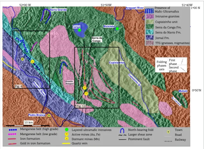
In the Amapari Greenstone Belt, the Vila Nova Group is composed by one sequence of maic metavolcanics, the Jornal Formation, outcropping at southwest, and two sequences of metasediments marked by topographic ridges, the Serra do Navio and the Serra da Canga Formations. hese sequences are intruded by syntectonic granitic stocks, which form a low-land topography between the ridges (Tab. 1).
he basement of the greenstone outcrops at southwest and northeast of the area. It is made of biotite and/or horn-blende gneisses and their foliation is parallel to the foliation of the greenstone.
52º00 W 51º50W 51º40W
1º00 N
0º50’N Fig. 4
Fig. 12
Manganese belt (high grade) Manganese belt (low grade) Iron formation
Gold in iron formation
Layered ultramafic intrusives Active mines (Au, Fe)
Dormant mines (Mn)
Quartz vein
North-bearing fold Larger shear zone Prominent fault
Town Road Railway
Presence of Mafic-Ultramafics
Intrusive granites
Cupixizinho unit Serra da Canga Fm.
Serra do Navio Fm.
Jornal Fm.
TTG (gneisses, migmatites)
Folding phases
axis Second phase
10 km
First phase
Covering the gneisses, the Jornal Formation is made of a more than three kilometers thick pile of orthoamphibo-lites (deined and formerly named as a group by Nagell 1962, Scarpelli 1966), derived from basalts, but not preserving rem-nants of the former igneous textures and structures. hey are constituted essentially by hornblende and plagioclase (andes-ine-oligoclase), always containing quartz and magnetite, and accompanied by accessory titanite, epidote, apatite, biotite and other minerals. hey are of medium grain size, massive with a weak layering, and with a nematoblastic texture marked by a constant orientation and dip to northwest of the prisms of horn-blende. he unit is regionally quite extensive, appearing as the Paramaka Formation in French Guiana, Suriname and Guyana. Saussuritization of plagioclase and chloritization of horn-blende are seen at shear and fault zones. A good example of such retrograde metamorphism into a chlorite schists is seen at the rapids of the Amapari River west of the C5 manganese mine (Fig. 4), where the formation is traversed by the shear zone that follows the T6, T4 and T20 manganese deposits.
At a few sites, the Jornal Formation contains lenses of quartz-mica schists in its basal portion. One of these occurs at west of Serra do Navio. here, a lens of schist extends for a few tens of kilometers to northwest, being marked by a 12 kilometers long ridge parallel to its foliation and made of a ine-grained pyrite-bearing quartz vein or metachert. here is no information regarding the origin of these schists, if metasediments or metavolcanics.
he Serra do Navio and the Serra da Canga Formations overlay the Jornal Formation. Both are made of ine clas-tic material and chemical components, represented by car-bonates, chert and iron oxides, all metamorphosed to the Amphibolite Facies, with local retrograde metamorphism into the Greenschist Facies along a few fractures, faults and shear zones.
hese metasedimentary sequences are better known in the areas of the mines of manganese, iron and gold, due to
intense drilling, opening of excavations, geological mapping, and geophysical and geochemical surveys. Other areas of the Vila Nova Group have not so much material for study. he laterally extensive area of occurrence of these sed-iments, together with the abundance of carbonates and
Age Unit Lithologies Mineralization
Quaternary Stream sediments Au, Sn, Ta
Triassic Cassiporé Diabase dikes
Paleo-proterozoic
Intrusive layered complexes
Canga
Mafic-ultramafic layered complexes Possible Cr, Ni, PGE Bicicleta
Syntectonic acid intrusives Granites, monzogranites, granodiorites Sn and Nb/Ta pegmatites
Vila Nova Group
Serra da Canga Fm. Platform marine metasediments Fe, Au, Mn
Serra do Navio Fm. Littoral/marine cyclothem Mn
Jornal Fm. Orthoamphibolites
Paleo-proterozoic
to Archean Basement Gneisses, migmatites, granitoids
Table 1. Stratigraphic column at Serra do Navio.
1 km
Town Railway Main Roads Contour Lines
Quartz vein Granitic intrusion Serra da Canga Fm. Serra do Navio Fm. Jornal Fm. Gneisses, migmatites
Mn ore outcrop Mn ore float Mn low-grade float Mining concession Shear zone Bedding Syncline Fault
chert, the alternation of layers, and the absence of coarse and medium grained sediments, suggests that they were deposited on a marine platform, with presence of littoral facies. heir layers have distinct composition and appear with thicknesses varying from centimeters to meters, with granulometry varying from ine to medium grained. hose derived from pelitic sediments have more micaceous min-erals (biotite, muscovite, chlorite, graphite), and are better foliated. Layers derived from quartzous and chemical sed-iments are more uniform and massive, lacking a good foli-ation, appearing as quartzites, marbles, manganese mar-bles, metachert, and banded iron formations. Amidst these end-terms, there are layers with intermediate compositions and textures.
Lafon et al. (2008) report Sm-Nd ages of 2.23 Ga. for orthoamphibolites of the Jornal Formation and schists of the Serra do Navio Formation, and Pb-Pb ages of 2.21-2.25 Ga. for syntectonic granites intrusive in the green-stones. hese ages correspond to the 2.18-2.09 Ga. period indicated by Kroonenberg et al. (2016) for the irst phase of the Transamazonian Orogeny in Suriname, expressed in the Marowijne Greenstone Belt by ocean loor magmatism, vol-canic arc development, sedimentation and metamorphism, accompanied by some anatexis and plutonism, a sequence of events that agrees with what is seen at Central Amapá.
he Amapari Greenstone Belt was actually afected by two phases of dynamothermal metamorphism, and between them there was one phase of thermal metamorphism caused by the syntectonic granitic intrusions (Scarpelli 1973, Chisonga et al. 2012). Before the second dynamothermal metamorphism, the Vila Nova Group was also intruded by a few layered maic-ultramaic complexes (Horikava & Ferreira Filho 2003).
Common porphyries, like garnets, were formed during both phases of dynamothermal metamorphism. Porphyroblasts formed during the thermal metamorphic episode are common, varying in composition and size depending on the composition and resistance of the host. Skarn-style porphyroblasts are frequent in carbonatic rocks near the granitic intrusives. Quite often, porphyroblasts preserve in their interior remnant minerals of the irst metamorphic phase.
During both dynamothermal metamorphisms, the group was folded into synclines, which are the most typical structure of greenstone belts, with anticlines only observed at areas of complex structures caused by faults and shear zones, or in domes formed by uprising syntectonic granitic intrusions. As indicated in Figure 3, while the second folding phase has their axis to northwest, the irst one has axis oriented to north-northeast, as indicated by the extensions of the Amapari and Ipitinga greenstone belts to southeast at their
southern extremities, and remnant folds axis to north-north-east, as seen at Serra Grande, north of Serra do Navio.
he shape of the greenstone belts, style of the major and minor folds and the dips of the beds, suggests that the pressure during the irst tectonic phase came from the east, while during the second came from the northeast. he meta-morphic grade in the second phase reached the Amphibolite Facies. Retrograde metamorphism occurred in less compe-tent lithologies and in zones afected by shears and faults.
Corresponding to the two phases of dynamothermal metamorphism, there are two main directions of shearing, the older to north-northeast and the younger to northwest, both following the main extension of the belts at the time they were formed. he shears to northwest are remarkably longer than the other shears and might correspond to the Transamazonian tectonic event. hey are characterized by lineaments with complex tectonic structures, recrystalliza-tion and, frequently, by faint to strong hydrothermalism and retrograde metamorphism, marked by chlorite, carbonates, sulides, epidote, tourmaline, and quartz veins and veinlets.
Some of the shears oriented north-northeast seem to constitute structures of the irst dynamothermal metamor-phism, reactivated in the second, and have the afected layers subparallel to them. Being oblique to the stress ield of the second phase of folding, they constituted areas of pressure release, and as such became favorable sites for appearance of open spaces used as channel ways for hydrothermal solu-tions. In efect, north-south shears control the most import-ant hydrothermal mineralization observed in the region.
he Paleoproterozoic syntectonic granitic intrusives are quartz-feldspathic, coarse grained, presenting muscovite and poor on femic minerals. Quite often, they have lakes of muscovite oriented parallel to the foliation of the green-stone rocks. Pegmatites intrude adjacent schists and some are mineralized in cassiterite and/or tantalite.
At Serra da Canga there are a few layered maic-ultra-maic intrusives, covered by several meters thick canga cap (lateritic duricrust). heir presence is indicated or suggested by the greater thickness of canga, scarcity of residual quartz and micas in the canga, and by magnetic anomalies.
Triassic diabase dikes related to the Central Atlantic Magmatic Province (Marzoli et al. 1999) are quite common in the area, but not marked in the map. hey usually form straight and long magnetic anomalies and on surface are recognized by loats of diabase and a dark brown soil. Most of them strikes to north and northwest and has thickness of a few to hundreds of meters.
THE SERRA DO NAVIO FORMATION
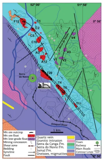
he Serra do Navio Formation, in sharp contact with the orthoamphibolites of the Jornal Formation (Figs. 3 and 4), is constituted by a cyclothem of ine-grained clastic and chemical sediments containing lenses of calcite mar-bles and rhodochrosite marmar-bles (Scarpelli 1973), the lat-ter constituting the protore of the mined out high-grade manganese-oxide orebodies (Nagell & Silva 1960, Nagell 1962). he formation is covered at northeast by the Serra da Canga Formation.
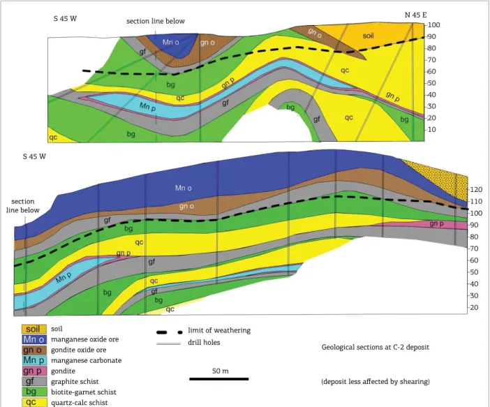
he cyclothem is shown in Figure 5, with transversal and longitudinal cross sections of the C2 mine, one of the deposits less afected tectonically. hree cycles were exposed there, each cycle starting with an oxide facies at base, cov-ered by a pelitic zone and ending up with a facies of reduc-tion (Scarpelli 1966, 1973).
The oxide facies is represented by cherts, lenses and disseminations of calcium carbonates, claystones and pos-sibly also siltstones, metamorphosed to siliceous to car-bonatic schists and limestones. The facies appears as alternating layers of muscovite quartzites, metacherts, plagioclase-muscovite-biotite-quartz schists, calc-sili-cate schists, tremolite-carbonate schists and marbles. The grain size varies from fine in the cherty layers to medium and coarse in the calc-silicatic units. The orig-inal layering is well preserved due to the differences of composition of the individual layers, and frequently the foliation expressed by the micaceuos minerals cut across the layering.
he intermediate facies is formed by metapelites meta-morphosed to a medium grained garnet(almandine)-bio-tite-quartz schists, in which the foliation is good and the original layering is usually diicult to recognize.
Figure 5. Serra do Navio Formation cyclothem in longitudinal and transversal sections of the C2 deposit (Scarpelli 1972). S 45 W
S 45 W
N 45 E section line below
section line below
100 90 80 70 60 50 40 30 20 10
120 110 100 90 80 70 60 50 40 30 20
soil
soil
manganese oxide ore gondite oxide ore manganese carbonate gondite
graphite schist biotite-garnet schist quartz-calc schist
limit of weathering drill holes
50 m
Geological sections at C-2 deposit
he facies of reduction was a pelite rich in organic mat-ter, locally with a transition to a lens of manganesiferous carbonate near the top. he pelite was metamorphosed into ine-grained quartz-biotite-graphite schists, and the lenses of manganesiferous carbonates to spessartite-rhodochrosite marbles, also containing pyroxmangite, picrotephroite, rho-donite and other silicates of manganese (Silva et al. 1963). he transition zones between the pelites and the manganesif-erous carbonates were metamorphosed into gondites (Leinz 1948), a coarse-grained rock made of spessartite, silicates of manganese, graphite and quartz. he garnets of the man-ganese marbles have less than one millimeter of diameter, and appear isolated in abundant ground mass, while those of gondites are greater, usually or more than 2 millimeters, and are more abundant, packed one to another. Under weathering the manganese marbles are oxidized to high-grade manganese ores and the gondites to low-high-grade ores. he deposition of the cycles seems to have occurred at the littoral zone of a stable marine platform, and was repeated due to advances-and-retreats of the sea level. Each cycle was initiated under open sea conditions, with deposition of the calcium car-bonates, chert, and siltic and pelitic materials, an environment typical of oxide facies sedimentation. With a decrease of the water depth, the deposition of chemical sediments slowly decreased and eventually ceased altogether, with only clays being depos-ited. With further decrease of the water depth, the environment became somewhat stagnant, swampy, and the sediments became rich in organic matter, an environment typical of reducing facies. Later in this facies, lagoons appeared and became sites for depo-sition of the manganesiferous carbonates (Scarpelli 1966, 1973). Quite signiicant, while the sedimentation was changing from oxide to reducing, the contacts between the alternating layers were dominantly transitional. In contrast, the transi-tions from the upper part of the reducing facies to the oxide phase of the next cycle are always abrupt, indicating rapid raising of the sea level (Scarpelli 1966).
he strong chemical contrast between the oxide and the reducing facies is well expressed by the diferent condi-tions required for deposition of carbonates of calcium and of manganese. While the deposition of calcium carbonates requires an environment of oxidation, characteristic of open sea, the deposition of carbonates of manganese requires a restricted and reducing environment. he observation that graphite occurs exclusively in the facies of reduction, in association to the manganese marble, led to the conclu-sion that the graphite-schists are product of pelites rich in organic matter, a typical product of swampy environments (Scarpelli 1966).
A petrographic study of the lithologies of the cyclothem (Scarpelli 1968) has shown that based on their porphyro-blasts and accessory sulides, they could be divided in ive distinct groups (Tab. 2), which seems to relect their difer-ent degrees of competence and even origin. he groups are:
■ Muscovite-biotite-quartz schists and metacherts;
■ Calc-silicate rocks and associated limestones from the oxide facies;
■ Almandine-biotite-quartz schists from the intermedi-ate facies;
■ Graphite schists;
■ Rhodochrosite marbles and gondites from the facies of reduction.
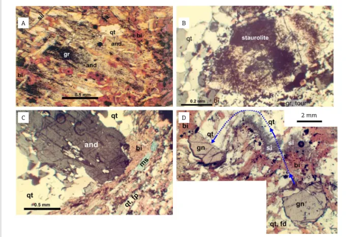
Andalusite, sillimanite and staurolite, indicators of met-amorphic conditions, appear in the silicatic schists with diferent frequencies, giving a hint about the diferential resistance of these rocks to the superposed phases of meta-morphism. Usually, the presence of staurolite indicates the higher pressure and temperature of metamorphism (PT), sillimanite an intermediate PT and andalusite the lower PT.
Frequently porphyroblasts that grew during the thermal metamorphism envelop and preserve as inclusions minerals of the irst dynamothermal metamorphism, making clear
Depositional Facies Lithologies Most Common Porphyroblasts Accessory Sulides
Reducing (graphitic)
manganesiferous marbles and
gondites
spessartite rhodonite picrotefroite pyroxmangite
niccolite
gerdorsite
sphalerite cobaltite
graphite schists andalusite >> sillimanite sillimanite >> staurolite
pyrite > chalcopyrite
Neutral (biotitic) almandine-biotite-quartz schists sillimanite >> andalusite = cordieritealmandine chalcopyritepyrite >>
Oxide
(quartzous, calcitic)
limestones, cherts and calc-silicate schists
diopside tremolite grossularite
pyrrhotite > arsenopyrite
muscovite-biotite-quartz schists, quartzites
almandine sillimanite >> andalusite
the diferences in structural orientation of the two phases of dynamic metamorphism (Fig. 6A).
Quartzous schists, usually less ductile and more resistant to the metamorphic stresses, are the favorite host for stauro-lite (Fig. 6B), which does not occur in the ductile micaceous schists. he well foliated garnet-biotite-quartz schist of the intermediate facies was quite able to dissipate metamorphic stresses, not appearing with staurolite. It avoided the meta-morphic stresses with displacements along the planes of foli-ation and displacements of its minerals (Figs. 6C and 6D). In the units rich in calcium carbonates, diopside is the more common porphyroblast, often replaced in total or at the edges by tremolite during the second dynamic metamorphism.
In the manganese marbles, very often there are crystals of rhodonite (MnSiO3) and/or picrotephroite ((Mn,Mg)3SiO4), occasionally one replacing the other. hese replacements are usually seen where the rock is fractured and where adjacent
non-carbonatic rocks present veinlets of quartz, which are never seen crossing the manganese marbles. Considering that pychrotefroite is unsaturated in silica in respect to rho-donite, the formation of one or the other might have been dependent of the volume of silica available during the crys-tallization of the mineral. In such a way, more silica would lead to rhodonite instead of picrotephroite, and vice-versa (Scarpelli 1966).
All rock samples of the cyclothem present accessory sul-ides, which are distinct for each rock group. Samples of the rhodochrosite marbles showed, without exception, presence of sphalerite, niccolite, cobaltite and gersdorite, suggesting a close relation with the orthoamphibolites of the footwall Jornal Formation. he graphite and the biotite schists appear with pyrite and occasional chalcopyrite; the metacherts pres-ent arsenopyrite; the marbles, calc-silicate schists and asso-ciated quartzites contains pyrrhotite; and galena was seen in
2 mm
A B
C D
a few quartz veins. Most of the sulide grains occur dissemi-nated in the rocks, but some were remobilized into veinlets. Both the manganese marbles and the associated gon-dites constituted protores for the oxide ores of manganese, described ahead.
THE SERRA DA CANGA FORMATION
he Serra da Canga Formation directly overlays the Serra do Navio Formation at west and the Jornal Formation at south, and, at north, it is in contact with basement rocks at the Rio Araguari (Figs. 3 and 4). he formation is well exposed at Serra da Canga, 15 kilometers to the east of Serra do Navio, after a lowland area with syntectonic granites. he Serra da Canga itself is marked by a prominent plateau at the elevation of about 250 meters above sea level, covered by a more than 8 meters thick cap of canga, an indurated duricrust made of massive limonitic laterite. Leaving the plateau to the south, this cap becomes thinner, with the topography marked by ridges formed by the rocks more resistant to erosion. Although scarce, outcrops of the formation are seen at the lanks of the plateau, and along the valleys between the ridges. he forma-tion was quite well detailed at south of the plateau during the exploration conducted for gold by Unigeo Geologia e Mineração, Minorco Brasil and AngloGold Ashanti, subse-quentially followed by the exploration for iron done by Min. Pedra Branca. A few drill holes in the plateau revealed two layered maic-ultramaic sequences intruding the formation.
Lowland topography in the area occupied by the formation marks the presence of syntectonic granitic intrusives.
At Serra do Veado, immediately to the east of the manga-nese mines of Serra do Navio, the basal part of the formation strikes north, in apparent structural discordancy with the Serra do Navio Formation (Fig. 4). his portion of the formation is constituted by a sequence with paramphibolites at base, cov-ered by quartz-biotite schist, biotite-cummingtonite-actino-lite schists, metachert, culminating with quartz-biotite schists containing a layer of gondite, loats of which accumulate in the areas V-1, V-2, V-3 and V-4. Shallow core holes in these areas revealed a few meters thick layer of oxidized gondite, with grades of 20 to 30% Mn. Tonnage, grade and content of silica were unattractive for economic exploitation. he gon-dite-bearing unit continues to the north, until Serra Grande (Fig. 3), where drilling also indicated low tonnages and sim-ilar grades of manganese and silica. Some holes in this area revealed a narrow band of graphite schist next to the gondite. he paramphibolites below the gondite-bearing horizon are composed of quartz, hornblende, actinolite, plagioclase, cli-nozoisite, plus minor percentages of biotite, chlorite, greenish diopside, epidote, carbonate, and other minerals. Contrasting with the orthoamphibolites, they are mineralogically well lay-ered, lack the massive nematoblastic texture that character-ize the orthoamphibolites, and magnetite is hardly seen. he sequence is considered to represent metamorphosed marls, deposited on calm marine platform. he formation sufered the same metamorphic phases observed with the Serra do Navio Formation.
Unit Characteristic Lithology
Clasto-Pelitic
Metasediments Sandy Domain Fine-grained quartzites: muscovite quartzites, muscovite-quartz schists, muscovite quartzites with fuchsite and/or sillimanite
Clasto-(Chemical) Metasediments
Pelitic Domain Mica schists: quartz-mica schists, garnet-quartz-biotite-muscovite schists, lenses of calc-silicatic rocks and iron formation
Transitional Quartz-grunerite-cummingtonite schists, quartz-amphibole schists, lenses of iron formation and calc-silicatic rocks
(Clasto)- Chemical Metasediments
Ferrous Domain
Silicatic iron formation: magnetite-grunerite-hornblende schists, garnet-hornblende-grunerite-diopside,
Oxide iron formation: coarse grained banded iron formation, with quartz, magnetite and
grunerite and occasional garnets; fine-grained banded iron formation with quartz and hematite
Silicatic iron formation: foliated to banded magnetite iron formation with grunerite and hornblende, and occasional diopside and lenses of marble
Calcic Magnesian Domain
Diopside calc-silicate rock; unfoliated rock with coarse grained diopside, plus calcite, quartz, actinolite; lenses of iron formation
Calcic-magnesian-silicate schists; foliated rock with hornblende, actinolite, diopside, magnetite, calcite, quartz, forsterite; lenses of marble
Marbles and carbonate schists: marble, carbonate schists with serpentine replacing olivine, actinolite, tremolite, diopside, forsterite, fayalite, hastingsite, cummingtonite,
chlorite and magnetite Manganese
Horizon Gondite or manganese-bearing schist, with/without a thin layer of graphite schist
Base Metamarls, Basic Metavolcanics
Paramphibolites; banded paramphibolites
Basic meta-volcanics; amphibole schists with cummingtonite, hornblende, biotite and magnetite, remnants of igneous textures.
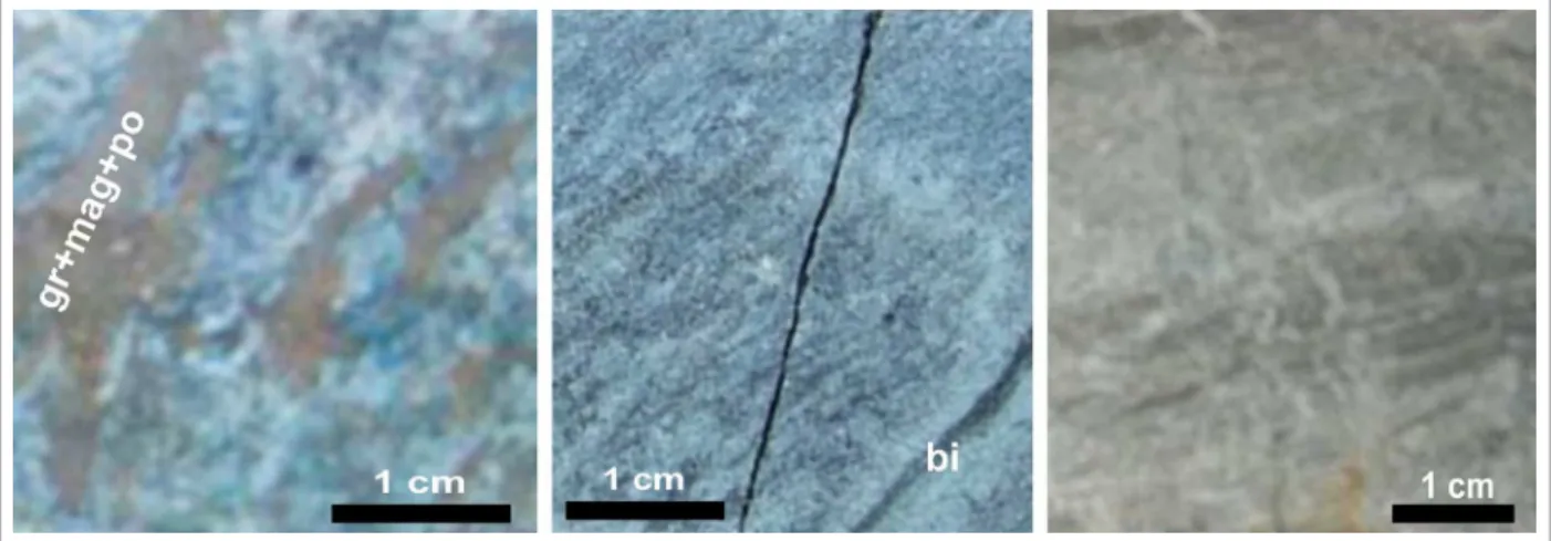
As shown in Table 3, above a basal section of amphi-bole schists and amphibolites, the sequence becomes essen-tially clasto-chemical, with a manganese-bearing unit at the base, changing upwards to calcic, to magnesian and to iron domains. he rocks of the Calcic-Magnesian Domain (Fig. 7), and the Ferrous Domain (Fig. 8), are marked by silicates of calcium, magnesium and iron, as diopside, tremolite, actinolite, serpentine, fayalite, forsterite, cummingtonite, grunerite, garnets and others, frequently accompanied by magnetite and sulides of iron. Layers of metachert are seen all throughout the sequence. At the upper part of the Ferrous Domain, after a ine-grained massive sillimanite quartzite, possibly a metachert, the chemical components diminish, and the formation becomes dominated by metapelites and metasiltites, metamorphosed into quartz-mica schists and gar-net-quartz-biotite-muscovite schists, with occasional lenses of calc-silicatic rocks and silicatic iron formation.
Quite important economically, the Ferrous Domain is marked by layers of silicatic and oxide banded iron forma-tions, which, besides quartz and iron oxides, contain sili-cates of iron, magnesium and calcium, often accompanied
by carbonates. he composition of the iron formation changes according to their position in the stratigraphy and the area of occurrence. he more common types, from the base to the top of the sequence, are those noted ahead (Horikava 2008):
■ Bif 1: Greenish gray and ine to medium grained, highly magnetic, composed mostly by bands of magnetite and quartz, containing diopside, locally with grunerite and occasional hematite;
■ Bif 2: Darker than Bif 1, it is highly magnetic and made of bands of magnetite and quartz containing silicates, amongst which garnets (andradite and grossularite) and grunerite and hornblende predominating over diopside. In hydro-thermally altered areas, they present pyrrhotite and pyrite in masses or in thin bands concordant to the layering (Fig. 8);
■ Bif 3: Intermediate to Bif 1 and Bif 2 in color and sili-cate content, it presents bands of hematite in addition to those of magnetite;
■ Bif 4: Bands of hematite and quartz, frequently with diopside, predominate over bands of magnetite. Locally resemble itabirites (Fig. 8).
Figure 7. Calcic-Magnesium Domain. Let: Impure and weakly foliated marble, with serpentine, brown grunerite, magnetite and pyrrhotite. Center: Carbonates, diopside, grunerite, with biotite in bands. Right: Impure marble with ine grained diopside
he clastic domain is better developed southeast of Serra da Canga, in the basin of the Cupixizinho River (Fig. 3). his area is poorly known, with the available information restricted to observations from scout exploration lines, lim-ited soil geochemistry, aerophotogeology and aerogeophysics. From what it is known, ridges of ine-grained quartzites and quartz-mica schists dominates the area, with lines of banded iron formation lanking it by the southwest and northeast. he area is crossed by a few shear zones, the greater follow-ing the valley of the Cupixizinho River.
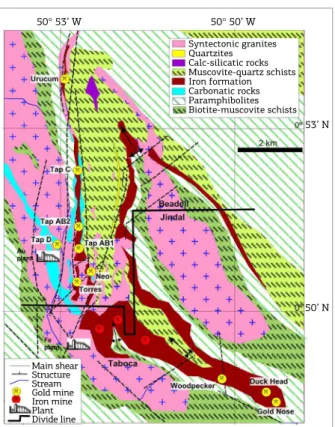
he area with the present gold and iron mines is shown in Fig. 9, which emphasizes the unit of iron formation that hosts the deposits. At east, the structures strike to northwest, characteristic of the second dynamothermal metamorphism, being highly deformed along a north-south shear zone, along which the beds, initially striking northwest, assumed a north-south strike, concordant to the shear and the granite at west. his shear zone seems to have been formed during the irst dynamothermal metamorphism, just reactivated in the second. It strongly afected the Serra da Canga Formation, steepen-ing, fracturing and faulting the beds, and its strike, oblique
in relation to the regional compression from the northeast, favored the appearance of open spaces used by the ascending hydrothermal solutions. he gold mineralization is about continuous along the 8 kilometers of iron formation par-alleled to the shear, from Urucum to Tap AB1 and Torres. Woodpecker, Duck Head and Gold Nose, important gold deposits in the iron formation, occur at the southern limb of the syncline east of Taboca. With the tectonic com-pression coming from the northeast, this limb was highly compressed and fractured against its footwall, with the frac-tures oriented to about north constituting good sites for hydrothermal deposition of mineralization.
Gold mineralization also occurs in non-iron formation units, as seen at Tap D, on a wedge of the Calcic-Magnesium Domain at west of the north-south shear. Still preserving the initial strike to northwest and the general dip to northeast, this wedge is composed of carbonatic and calc-silicate schists contain-ing auriferous concentrations of sulides (pyrite, pyrrhotite, plus chalcopyrite and arsenopyrite), appearing as disseminations and replacements of carbonates and silicates. Nearby, the Unigeo/ Minorco soil sampling identiied attractive anomalies of cop-per, lead and zinc which seems to have not been examined yet.
CANGA AND BICICLETA:
MAFIC-ULTRAMAFIC LAYERED INTRUSIVES
he only rock exposures seen at the Serra da Canga appear at the lanks of the canga covered plateau, in the form of weathered schists and quartzites.
Two scout drilling campaigns were realized on the plateau, one over a magnetic anomaly at Canga, at its northern por-tion, and the other at Bicicleta, 12 kilometers to the east, over a soil geochemical anomaly of nickel (Fig. 3). Both campaigns revealed metasediments of the Serra da Canga Formation intruded by lithologies corresponding to layered maic-ultra-maic complexes (Horikava & Ferreira Filho 2003). All cored rocks have been metamorphosed to the Amphibolite Facies. At Canga, the intrusives appeared in 3 out of 13 holes, with intersections of 26, 94 and 120 meters, and their struc-ture was not clearly deined. he hole with 26 meters of inter-section exposed a complete inter-section of the intrusion. At base, it presented layers of metaperidotite, passing to metapyrox-enite and ending above with layers of metagabbro (Fig. 10). he hole with 94 meters of intersection exposed only meta-pyroxenite. he hole with 120 meters of intersection missed the upper part of the intrusion. At base, it presents meta-peridotites, which are overlain by layered metapyroxenites, that pass upwards into saprolite and canga. he ultramaic rocks present moderate primitive composition, with MgO 18.5-24.7%, Mg No 0.45-0.54, CaO 4.0-9.6% and Cr2O3 0.15-0.18% (Horikava & Ferreira Filho 2003).
Figure 9. Geology of the area with the gold and iron mines of Beadell and Jindal. The larger gold deposits occurr in iron formation, controlled by shears and faults. At west of the major controlling shear, TapD gold deposit occurs in a wedge of the Calcic-Magnesian Domain. Mineral rights of the complete area belongs to Beadell, with Jindal owning rights to exploit iron south of the divide line. (Base geologic map from Horikava E.H. 2008).
Syntectonic granites Quartzites Calc-silicatic rocks Muscovite-quartz schists Iron formation Carbonatic rocks Paramphibolites Biotite-muscovite schists
Main shear Structure Stream Gold mine Iron mine Plant Divide line
50° 53’ W 50° 50’ W
53’ N
In detail, the basal metaperidotites are formed by alter-nating layers of olivine, amphiboles (cummingtonite and tremolite) and chlorite. In the transition zone to the overlying pyroxenites there is a foliated olivine tremolitite. he meta-pyroxenite is made of tabular clinopyroxene crystals partial to totally replaced by hornblende. Its transition to metagab-bro is marked by small crystals of plagioclase between the tabular clinopyroxene. he metagabbro is made of horn-blende and plagioclase in diablastic and nematoblastic tex-tures. he sequence suggests fractionated crystallization, from olivine to olivine + clinopyroxene, to clinopyroxene, and to clinopyroxene + plagioclase.
At Bicicleta, amidst passages of metasediments of the Serra da Canga Formation, four out of eight holes intersected meta-peridotites similar to those ones of the Canga area and ortho-amphibolites that seems to represent metamorphosed gabbros. Horikava and Ferreira Filho (2003) inform that the two sequences present characteristics of layered maic-ultramaic intrusives, suggesting that they originated from a basic magmatic chamber under diferentiation. hey suggested that these rocks could host concentrations of nickel, copper, and platinoids.
he aerogeophysical map made by Serviço Geológico do Brasil (CPRM) indicates other magnetic anomaly near the drilled areas, suggesting extensions of these intrusions or additional intrusions of the same type.
SYNTECTONIC
GRANITIC INTRUSIVES
Several syntectonic granitic masses intrude the greenstone belts, which they tectonically deform, thermal metamorphose
and also intrude with pegmatites. heir composition varies from granites to monzogranites and to granodiorites (Tavares 2009). Most have an elongated form, doming the intruded lithologies, quite often showing a foliation parallel to the foliation of intruded rocks.
Some appear as dikes in fractures and fault planes, as those seen in the shear zone that host the Tucano gold deposit, as shown in Figure 9. Other ones intrude former intrusions, forming large masses as the Silvestre Granite, which is actually composed of several intrusions, of dii-cult individual deinition.
Some of the pegmatites intruded in the metamorphic rocks are mineralized with cassiterite or columbite-tan-talite, constituting the source of concentrations of these minerals in streams of the area, intermittently exploited by garimpeiros. Historically, the main centers of this mining are the basins of the creeks Jornal and Silvestre, at west of the Tucano gold mines, and also in several creeks at the basin of the Cupixizinho River. Sporadically, small mine compa-nies open up a mineralized pegmatite, which they mine for a couple of years. here is no information of about anyone doing a sustained campaign to identify large pegmatites.
MANGANESE ORES
OF SERRA DO NAVIO
he manganese ores which occur in the Serra do Navio Formation can be split in two groups, the oxides and hydroxides of manganese and iron, product of weathering and supergene enrichment of the manganese marbles and associated metased-iments, and the fresh manganese marbles themselves. Today, Figure 10. Details of the 26 meters drill intersection of a maic-ultramaic intrusion in the Serra da Canga Formation at Canga. (From Horikava & Ferreira Filho 2003).
17 m 2 m 7 m
amphibolite and graphitic schist
metagabbro
metapyroxenite
metaperidotite
the resources of oxides and hydroxides are about exhausted, but those of carbonates were barely touched. he preferen-tial mining of the oxides and hydroxides was favored by the large market represented by the metallurgical industry, while the carbonates, mined only in the last years of activity of the mine, have a limited market and heavy chemical constraints.
Under the conditions of extreme weathering of the Amazon rainforest, supergene alteration of the Serra do Navio Formation normally reached depths of 50 to 60 meters, surpassing 100 meters in the more carbonatic zones. In the process, minerals were dissolved and the majority of elements were solubilized. Some, as manganese, iron and aluminum, reprecipitated in the form of oxides and hydrox-ides, in many cases practically in situ, replacing the dissolved carbonates, sulide and silicates. he newly formed minerals are not essentially stable, as there is evidence of a continuous process of dissolution, leaching and reprecipitation, leading to higher and higher concentrations of manganese. At the end, large blocks of massive manganese ores were formed and stayed in the weathered zone, together with clays and other secondary minerals, being fundamental to form ridges where they occur (Dorr et al. 1950).
he main manganese minerals formed are cryptomel-ane, a hydrated potash-bearing manganese oxide, accom-panied by pyrolusite, manganite and a few other miner-als like lithiophorite (Valarelli 1967), which intermixed
with iron and aluminum oxides and hydroxides consti-tute the compact masses. Small quantities of metals like zinc, arsenic, cobalt and nickel are retained within the crystalline structure of the manganese and iron oxides and hydroxides.
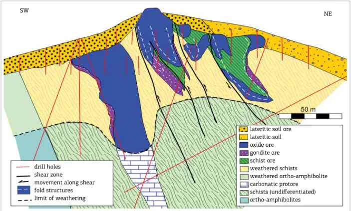
Figure 11 presents a cross section of the T6 mine, at the southern end of the line of orebodies of Serra do Navio. he structure is complex due to the shear zone that pushed up the ore blocks from northeast. here are ive types of ores:
■ he oxide ore, assaying more than 44-48% Mn, result of in situ oxidation of the manganese marbles;
■ he low grade and silicatic gondite ores derived from oxidation of gondites;
■ he schistous ores, formed by impregnation of manga-nese oxides in graphitic and carbonatic schists;
■ he lateritic ore, formed by the accumulation of granzon (suricial supergenic round nodules of iron-manganese hydroxides) and boulders of massive manganese oxide ores at the lanks of the hills;
■ he carbonatic protore.
he oxide ore types were exhausted down to the contact with the carbonatic ore, that was not mined.
he exploitation of the manganese ores was done by ICOMI from 1957 to 1998, being interrupted when the resources became small and the production became
Figure 11. Cross section of the T6 mine, showing efects of the shear zone on structures, depth of weathering and ore types. The oxide ores were mined out.
lateritic soil ore lateritic soil oxide ore gondite ore schist ore weathered schists
weathered ortho-amphibolite carbonatic protore
schists (undifferentiated)
ortho-amphibolites
NE SW
drill holes shear zone
uneconomical. During its activities, ICOMI sold 31 mil-lion tons of washed oxide ore assaying from 42 to 49% Mn, 1.8 million tons of manganese pellets, sinter feed and ines, and 0.9 million ton of carbonate ore assaying about 30% Mn. Most of the carbonate ore produced came from the F12 mine, at the northern end of the line of mines, mostly due to its better topographic situation.
he initial exploration was done with mapping, trenching and drilling. Geologic mapping and additional drilling con-tinued during the life of the mine, to improve the operation and to ind reserves to replace the mined tonnage (Marotta et al. 1966). On a few occasions, gravimetry was used to identify deposits hidden below barren ground.
Mining was done in open pits and other suricial excava-tions. During the opening of the pits, barren and weathered schists at the sides of the ore were stripped of and deposited as waste at the lanks of the hills, which were later recovered with revegetation. For most of the time, the ratio of ore to waste was of about 1 ton of run-of-mine to 1 m3 of waste.
he run-of-mine, constituted by the ore and intervening masses of weathered schists, was sent to a beneiciation plant, where it was crushed, washed and screened. In the process, about 10% of the feed, essentially clays, was eliminated as tailings. he recovered products were constituted by clean fragments of the ore, classiied in various commercial sizes. he fragments smaller than 0.8 centimeters were submitted to gravimetric concentration, the coarser of them with dynawhirl-pools, set to work at the density of 3 g/cm3, and the iner with Humphrey spirals. In both cases, the lighter fragments were discarded (Rodrigues et al. 1986). To improve the commer-cialization of the recovered ines, a pellet plant was built and operated near the port. For commercial reasons, after some years, this plant was changed to produce sinter feed.
he main constituents of the products were manganese and iron, at a ratio of about 6 to 10:1. It is important to note that this ore contained a very small but important quan-tity of arsenic, irmly locked in the crystal structures of the ore minerals. he ratio Mn:As was quite stable, at about 3,000:1, that is, an ore product with 48% Mn would have 0.016% As. Metallurgical tests done before the opening of the mine revealed that in the steel industry the arsenic of the ore is not liberated to the air and stays inert, ixed as a metal in the produced steel.
To operate the mine, in the 1950s ICOMI built a 192 kilometers long captive railway from Serra do Navio to Santana, near Macapá, where it built an also captive port. Besides all necessary installations, inclusive a diesel oper-ated power plant for the generation of energy at Serra do Navio, two model villages were constructed for the employ-ees, both with hospital and schools, one at Serra do Navio and another near the port.
Today, while the remaining resources of high-grade oxide ore are negligible, the resources of carbonate ores, which were just touched at the bottom of some of the pits, are there to be considered for underground mining opera-tions, when price and market requirements become attrac-tive. As time goes by, eventually low-grade deposits at the base of the Serra da Canga Formation might become inter-esting to mine.
When the exploitation was terminated, ICOMI left at surface piles with slightly more than 5 million tons of crushed, washed and classiied oxide ore with 17 to 36% Mn, not sold due to a lack of buyers when they were produced, but with a clear chance to be sold at present day conditions. On addition, at the sides of the old pits there are large piles of low-grade resources, made of a mix of schistous and gondite ores and residual clays, roughly averaging 15 to 25% Mn, which could eventually be used to produce saleable products.
GOLD DEPOSITS, THE TUCANO MINE
Gold mineralization in the iron formation was identi-ied and explored by Unigeo and Minorco, both subsidiaries of Anglo American do Brasil, under the name of Amapari Project. It was taken over by AngloGold Ashanti when the Anglo Group split in two, and shortly after it was sold to Mineração Pedra Branca do Amapari Ltda. After commis-sioning the mine with a heap leach plant and operating it for a while, Min. Pedra Branca sold it to Wheaton Mining, that subsequently sold it to New Gold. In 2010, Beadell Resources Ltd. acquired the project and is keeping it in continuous operation, under the name of Tucano Mine. Due to the local heavy rain conditions, the heap leach pro-cess always had problems and, to improve gold recovery, soon after the acquisition Beadell installed a 3.5 million tons per year carbon in leach (CIL) plant, which started to operate at the end of 2012. From 2005 to the end of 2016, the accumulated production reached about 28.6 tons of gold, of which 18.7 tons by Beadell.
100 meters, together with geologic mapping and sampling of outcrops and excavations opened by the garimpeiros. he work revealed the 8 kilometers long mineralization from Urucum to Tap AB1. Immediately after, two drilling cam-paigns were initiated, with reverse circulation holes for soil and saprolite, and with diamond core holes for fresh min-eralization at depth. Subsequent exploration by AngloGold Ashanti, Min. Pedra Branca and Beadell lead to the identi-ication of several gold deposits in the heavily faulted area at southeast of TapAB1 and along the southern limb of the syncline southeast of this area. More orebodies continue to be found in these areas.
he deposition of gold in the iron formation occurred when sulfur-rich auriferous hydrothermal solutions, ascend-ing through favorable pathways in the shear zone and fault structures, reached the iron-rich minerals and reacted with them, collected iron from the magnetite and iron silicates and dumped iron and sulfur as sulides, in the process also precipitating silica, carbonates and the gold.
he pattern and intensity of mineralization varies from place to place, from disseminations to massive ore shoots, with combined thickness of up to 25 meters (Fig. 12).
he orebodies are composed of concentrations, bands, veins, veinlets and disseminations of ine-grained silica, carbonates and sulides, which ill open spaces and totally or partially replace the host rocks. he initial data indicated a dominance of pyrrhotite at north and pyrite at south, fol-lowed by variable quantities of arsenopyrite, chalcopyrite and galena. Gold occurs in free form or included in the sulides (Horikava 2008). he width of the hydrothermal alteration of the host rocks is quite narrow, limited to the very margins of the ore masses, constituted by siliciication accompanied by dissemination of sulides.
he weathering is intense, and in the mineralized zone it reaches more than 100 meters of depth. After the leach-ing of the soluble components of the rocks, gold was con-centrated together with secondary oxides and hydroxides of iron and aluminum, residual silica and clays, forming both a rich saprolite and a rich colluvium that reaches up to 25 meters of thickness and spreads laterally downslope of the hill. Both the rich saprolite and the mineralized colluvium constitute the oxide ore and are being mined open cast, together with masses of fresh mineralization available at the bottom of the pits (Fig. 13).
When the property was sold to Wheaton Mining, the total resources estimated with the data collected by Unigeo/Minorco, reached 20 million tons at 1.8 g/t of oxide ores for surface mining, plus 8 million tons at 5.6 g/t of sulide ores for underground mining. When Beadell took over, a new estimation of the resources indicated 23 million tons at 1.45 g/t for surface mining, plus 20 million tons at 2.21 g/t of sulide ore. he numbers for oxide ores and surface mining are similar in both esti-mates, but the grade for underground operation indi-cates strong dilution in the Beadell’s estimate (Beadell Resources 2017).
As declared by Beadell (Beadell Resources 2017), at the end of 2017 the estimated available reserves reached 20.9 mil-lion tons at 1.69 g/t Au of weathered and primary mineral-ization for surface mining, and 3.0 million tons at 3.61 g/t Au for underground mining at Urucum, where the irst pre-feasibility study for underground mining had just in-ished (Fig. 14). he estimated total in situ resource reached 54.7 million tons at 1.97 g/t, plus 5.8 million tons at 0.63 g/t of stockpiles. hese numbers are due to grow, as the com-pany is continuously identifying new orebodies, and the known orebodies are open in depth.
At this point, it might be important to note that Beadell retains the rights to explore and exploit gold mineralization in the area of Jindal, what it is the case of the Duck Head, Woodpecker and Gold Nose gold deposits.
In a presentation to their shareholders early in 2016, Beadell Resources informed the discovery of gold mineralization in Figure 12. Initial geologic proile of the Urucum
orebody, as prepared by Minorco. Mineralization is preferentially hosted in the faulted iron formation. Values next to the trace of the holes indicates grades of gold (g/t Au) and meters of mineralization.
NW
20 m
NE 300
280
260
240
220
200
180
160
140
120
100
80
160
140 Colluvial ore
Oxide ore Sulfide ore Oxide iron formation Silicate iron formation Calc-silicate schist Silicatic marble Paramphibolite Quartz-mica schist Granite
Percussion holes
iron formation at Mutum, at the headwaters of the Carneiro creek, 20 kilometers east of Tucano. Initial shallow auger holes revealed values up to 5.13 g/t over 7 meters. heir initial geologic map indicates the presence of three paral-lel lines of iron formation oriented to north-west, with the southern of them dragged to a north-south strike for 2 kilo-meters, possibly following a fault. here are gold anoma-lies in soil over the three lines of iron formation, with the better grades coinciding to where the southern line is ori-ented north-south.
IRON ORE DEPOSITS,
THE MINE OF JINDAL
The iron resource in the area of Jindal Group easily reaches 500 million tons of mineable iron ore. MMX Mineração explored that portion of the iron formation and, supported on a proven resource of 267 million tons, reshuffled the railway from Serra do Navio to Santana and the port formerly used by ICOMI, built one washing and concentration plant and ancillary Figure 13. North-south line of pits opened by Beadell, with Tap AB1 in the irst plane, Tap AB2 and Tap C in sequence, with Urucum in the horizon, near to the high plateau of the Serra da Canga. Photo from Beadell open presentation of November of 2016.
Figure 14. Longitudinal section of the 2.2 kilometers long Urucum pit, outlining exploited and unexploited portions of the main orebodies of the deposit, which plunge north, are crossed by one large pegmatite, and are open in depth. The pit surpasses 250 meters of maximum depth. At north, Beadell identiied a reserve for underground mining totalling 3.0 million tons at 3.61 g/t Au. (Based on illustrations presented by Beadell Resource 2010-2017).
200
0
-200
-400 m N S 2016 bottom of pit Initial topography
Mined out oremasses
Oremasses to mine Defined reserve for underground mining
installations, and initiated the mining. With the oper-ation going at full speed, it was sold to Anglo American do Brasil, included in the same deal that involved the selling of the Minas-Rio Project, in the state of Minas Gerais. During 2012, Anglo produced and sold 6 million tons. In 2013, at about the occasion when an accident affected the structure of the port, the project was sold to Zamin, which have not provided the recovery of the port and interrupted the activities. The Jindal Group has acquired the property and is recovering the mine, the port and the railway.
he accident at the port was due to the clayous and fragile nature of the margin of the Amazon River. In the engineer-ing of the port, ICOMI avoided heavy installations at the margin of the river, installing instead a loating deck, tied to two +100 meters long vertical piles ixed in compact layers of sediment found below the fragile sediments. For nearly 50 years, the manganese ores were transported to the ships via an elevated conveyor supported on the loating deck and on a safe point away of the margin of the river. Probably ignoring the reason of that engineering and without access to the construction project, the new port operators set aux-iliary installations and activities close to the the margin of the river, causing the accident.
he mineable ore varies from massive, when originated from oxidized magnetite-rich iron formation, to friable, derived from less oxidized hematite-rich iron formation (Fig. 15). In every case, magnetite is replaced by martite, silicates are leached, and limonite cements the fragments (Fig. 16). he weathering gets to more than 100 meters of depth, and invariably the outcrops are massive and very hard, formed by well cemented martite, hematite and limonite. Friable hematitic iron formation, occasion-ally indicated by a few residual blocks in canga, are only exposed on excavations and road cuts.
Grades, mineralogy, consistency and size of ore products vary with depth. Compact ores, good to produce lumps and natural pellets of high grade, are formed by martite-rich layers and also by rich canga formed by bulky cementation by limonite of blocks of oxidized iron formation. Friable ores, mostly made of hematitic ore, are good to produce medium- to ine-grained concentrates of good grade.
CONCLUSIONS
For question of space, the authors did not present infor-mation regarding mineral deposits and occurrences indicated in Fig. 2, but outside the limits of Fig. 3.
In general terms, the occurrences of manganese carbon-ates, oxides and gondites occur at the base of the column
of metasediments of the Vila Nova Group. Units of banded iron formation appear higher in the stratigraphy, form topo-graphic ridges and are conspicuous in aerial magnetometry. Gold occurs in a variety of environments, with the larger concentrations related to shears and faults oriented to north, a favorable direction to have open spaces for the lux of hydrothermal solutions. Iron formations and carbonatic metasediments of the Vila Nova Group are the favorite host for hydrothermal mineralizations. In this sense, it seems wise to examine geochemical anomalies of copper, zinc and lead in the areas where hydrothermalism is identiied.
Maic-ultramaic layered complexes intrude the Vila Nova Group and have potential for chromite and magne-tite, as seen at Santa Maria with the Bacuri deposit, besides eventual platinum group elements, nickel and vanadium. hese complexes rarely outcrop, their presence suggested
Figure 15. Exposures of iron formation in the area of Jindal. Let, outcrop of the ore, represented by a massive and erosion resistant magnetite/martite-rich unit. Right, exposed on a road cut, the friable hematitic iron formation, a type that never outcrops and is the favorite for mining due to its high grade and low cost to mine and process.
Beadell Resources. 2017. Informations regarding Tucano and Mutum. Available at: http://www.beadellresources.com.au [cited at Jul. 2017].
Chisonga B., Gutzmer J., Beukes N.J., Huizenga J.M. 2012. Nature and origin of the protolith succession to the Paleoproterozoic Serra do Navio manganese deposit, Amapá Province, Brazil. Ore Geology Reviews, 47:59-76.
Cordani U.G., Ramos V., Fraga L.M., Cegarra M., Delgado I., Souza K.G., Gomes F.E.M., Schobbenhaus C. 2016. Tectonic Map of South America, second edition, 1:5,000,000. Commission for the Geologic Map of the World.
Cordani U.G. & Teixeira W. 2007. Proterozoic accretionary belts in the Amazonian Craton. Geological Society of America Memoir,
200:297-320.
Dorr J.V.N., Park Jr. C.F., Paiva G. 1950. Manganese deposits of the Serra do Navio District, Territory of Amapá, Brazil. United States Geological Survey Bulletin, 964(A):1-39.
Dorr II J.V.N., Park Jr. C.F., Paiva G. 1950. Depósito de Manganês do Distrito de Serra do Navio, Território Federal do Amapá. DNPM-DFPM, bol. 85
Horikava E.H. & Ferreira Filho C.F. 2003. Corpos Máicos-Ultramáicos
Acamadados da Região da Serra do Navio. In: VIII Simpósio de Geologia da Amazônia, Expanded Abstracts, Sociedade Brasileira de Geologia, CD-ROM.
Horikava E.H. 2008. Geoquímica de Solo e Geologia da Região do Depósito de Ouro do Amapari – AP. MS Dissertation, Universidade Federal de Minas Gerais, 2 vol.
Kroonenberg S.B., Roever E.W.F., Fraga L.M., Reis N.J., Faraco M.T., Lafon J.M., Cordani U., Wong T.E. 2016. Paleoproterozoic evolution of the Guiana Shield in Suriname: A revised model. Netherlands Journal of Geosciences, 95(4):491-522.
Lafon J.M., Tavares R.P.S., Tassinari C.C.G., Barros C.E.M. 2008. Idade,
Caracterização Geoquímica e Isótopos de Nd dos Anibolitos do
Grupo Vila Nova e Granitóides Associados na Serra do Navio, Borda Norte do Bloco Arqueano Amapá: Implicações Geodinâmicas. In: Anais Congresso Brasileiro de Geologia, 44, Curitiba, p. 59.
Leinz V. 1948. Estudo Genético do Minério de Manganês da Serra do Navio, Território do Amapá. In: Anais da Academia Brasileira de Ciências, Ano XX, 2:213-221.
Lima M, Montalvão R., Issler R., Oliveira A, Basei M., Araujo J., Galeão da Silva G. 1976. Folha NA/NB.22, Macapá. Projeto Radam; MME-DNPM Levantamento de Recursos Naturais, V-6, Geologia,
Marotta C.A., Scarpelli W., Maruo J., Barbour A.P., Lima L.G.B. 1966. Notas sobre o Distrito Manganesífero de Serra do Navio. Anais da VI Conf.Geol. Guiana, DNPM, Avulso 41, 57-69
REFERENCES
Marzoli A, Renne P.R., Piccirillo E.M., Ernesto M., Bellieni G., De
Min A. 1999. Extensive 200-million-year-old continental lood
basalts of the Central Atlantic Magmatic Province. Science,
284(5414):616-618.
Nagell R.H. & Silva A.R. 1960. O Carbonato de Manganês como Protominério no Distrito de Serra do Navio. In: XIV Congresso da Sociedade Brasileira de Geologia, Brasília.
Nagell R.H. 1962. Geology of the Serra do Navio manganese district, Brazil. Economic Geology, 57(4):482-498.
Rodrigues O.B., Kosuki R., Coelho Filho A. 1986. Distrito Manganesífero de Serra do Navio, Amapá. Principais Depósitos Minerais do Brasil. In: Ferro e Metais da Indústria do Aço. Departamento Nacional da Produção Mineral, Vol II, Cap XIV.
Rosa-Costa L.T., Lafon J.M., Delor C. 2006. Zircon geochronology and Sm-Nd isotopic study: Further constraints for the Archean and Paleoproterozoic geodynamical evolution of the southeastern Guiana Shield, north of the Amazonian Craton, Brazil. Gondwana Research, 10(3-4):277-300.
Scarpelli W. 1966. Aspectos genéticos e metamóricos das rochas do
Distrito de Serra do Navio. In: Anais da VI Conferência Geológica das Guianas, DGM-DNPM, Avulso 41, p. 37-56.
Scarpelli W. 1968. Precambrian Metamorphic Rocks of Serra do Navio, Brazil. Unpublished Report on Student Research Project, Stanford University.
Scarpelli W. 1973. The Serra do Navio Manganese Deposit (Brazil). In: Unesco – Proceedings of the Kiev Symposium on the Genesis of Precambrian Iron and Manganese Deposits, p. 217-228.
Schobbenhaus C., Campos D.A., Derze G.R., Asmus H.E. 2001; Mapa Geológico do Brasil e da Área Oceânica Adjacente incluindo Depósitos Minerais; 1:2,500,000; DGM-DNPM
Silva A.R, Scarpelli W., Marotta C.A. 1963. Contribuição ao Estudo dos Protominérios de Manganês do Distrito de Serra do Navio. Boletim da Sociedade Brasileira de Geologia, 12:37-48.
Spier C.A. & Ferreira Filho C.F. 2001. The chromite deposits of the
Bacuri Maic-Ultramaic Layered Complex, Guyana Shield, Amapá
State, Brazil. Economic Geology, 96(4):817-835.
Tavares R.P.S. 2009. Granitóides e Anibolitos da Sera do Navioo, Borda Norte do Bloco Arqueano Amapá: Caracterização Petrográica
e Geoquímica, Geocronologia Pb-Pb em Zircão e isòtopos de Nd. MS Dissertation, Universidade Federal do Pará.
Valarelli J.V. 1967. O Minério de Manganês da Serra do Navio, Amapá. PhD Thesis, Universidade de São Paulo, São Paulo.
Available at www.sbgeo.org.br
by magnetometry, soil geochemistry, and a thick cover of canga poor in quartz and other resistant primary minerals.
Alluvial concentrations of cassiterite and tantalite-columbite derive from pegmatites related to the syntectonic granites that intrudes the Vila Nova Group. A dedicated exploration cam-paign for large tantalum-bearing pegmatites would be acceptable.