www.nat-hazards-earth-syst-sci.net/8/483/2008/ © Author(s) 2008. This work is distributed under the Creative Commons Attribution 3.0 License.
and Earth
System Sciences
Rainfall-triggered landslides in the Lisbon region over 2006 and
relationships with the North Atlantic Oscillation
J. L. Zˆezere1, R. M. Trigo2,3, M. Fragoso1, S. C. Oliveira1, and R. A. C. Garcia1 1Centro de Estudos Geogr´aficos, Universidade de Lisboa, Portugal
2CGUL, IDL, Faculdade de Ciˆencias, Universidade de Lisboa, Portugal
3Departamento de Engenharias e Ciˆencias Naturais, Universidade Lus´ofona, Portugal
Received: 3 January 2008 – Revised: 7 May 2008 – Accepted: 7 May 2008 – Published: 15 May 2008
Abstract.Landslides occurred in the Lisbon area during the last 50 years were almost always induced by rainfall and have been used to establish rainfall thresholds for regional land-slide activity. In 2006, three new rainfall-triggered landland-slide events occurred in the study area, namely on the 20 March, the 25–27 October, and the 28 November. Landslide events occurred in March and October 2006 include shallow transla-tional slides and few debris flows, and the corresponding ab-solute antecedent rainfall was found to be above the thresh-old for durations ranging from 4 to 10 days. These events also fit the combined threshold of daily precipitation and 5 days calibrated antecedent rainfall values. Likewise the land-slide event that took place in late November 2006 includes some slope movements with deeper slip surfaces, when com-pared with landslides dating from March and October. More-over, the corresponding absolute antecedent rainfall was also found to be above the 40-day period rainfall threshold.
Here we characterize in detail the short and long-term at-mospheric circulation conditions that were responsible for the intense rainfall episodes that have triggered the corre-sponding landslide events. It is shown that the three rainfall episodes correspond to considerably different synoptic atmo-spheric patterns, with the March episode being associated to an intense cut-off low system while the October and Novem-ber episodes appear to be related to more typical Atlantic low pressure systems (and associated fronts) travelling eastwards. Finally, we analyse the role played by the North Atlantic Oscillation (NAO) during those months marked by landslide activity. It is shown that the NAO index was consistently neg-ative (usually associated with above average precipitation) for the months prior to the landslide events, i.e. between
Oc-Correspondence to:J. L. Zˆezere ([email protected])
tober 2005 and March 2006, and again between August and October 2006.
1 Introduction
High intensity rainfall episodes and long lasting rainfall episodes are recognized as major landslide triggering factors worldwide (Wieckzorek, 1996; Corominas, 2001; Guzzetti et al., 2007). The definition of rainfall amount/duration crit-ical values for slope instability has been attempted for more than 25 years (e.g. Caine, 1980; Fukuoka, 1980; Crozier, 1986). These efforts have been performed in the framework of both “pure” and “applied” research mostly carried out with the aim of landslide risk mitigation (e.g. Keefer et al., 1987; D’Orsi et al., 1997; Aleotti, 2004).
Nevertheless, despite the large amount of work done with this goal (e.g. Van Asch et al., 1999; Corominas, 2001; Polemio and Petrucci, 2000; Zˆezere et al., 2005; Guzzetti et al., 2007; among others), it is now recognised that there is no general “universal rule” regarding rainfall thresholds related with slope instability. Additionally, within a single region, different types of slope movements are usually related with distinct hydrological triggering conditions that may be pro-duced by different rainfall episodes (Van Asch et al., 1999; Polemio and Petrucci, 2000; Zˆezere, 2000; Corominas, 2001; Zˆezere and Rodrigues, 2002; Trigo et al., 2005).
T
a
g
u
s
R
iv
e
r
Montejunto
Sintra
Lisbon
Cascais
Loures
Mafra
Arruda dos Vinhos
Alenquer
Torres Vedras
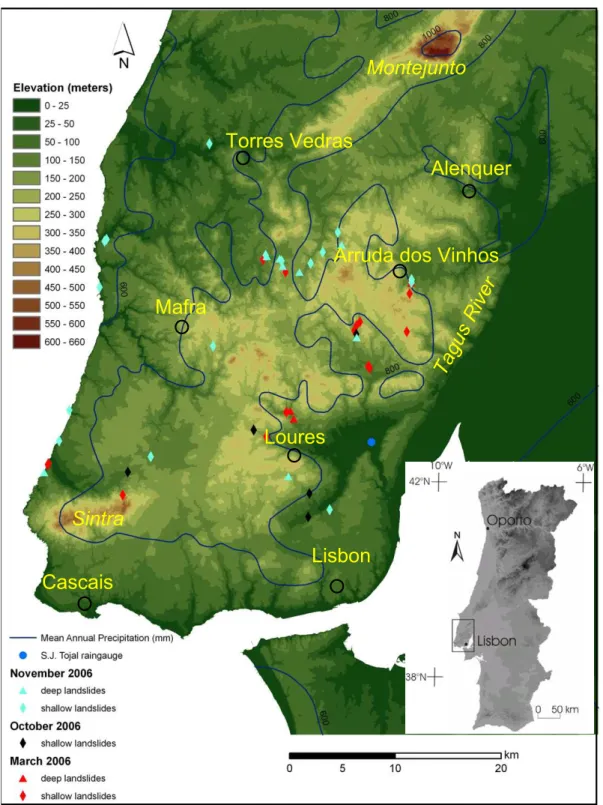
Fig. 1.Location and elevation of the study area, and distribution of landslides occurred in 2006. Mean Annual Precipitation (MAP) values for the period 1931–1960 are also represented (source: Daveau et al., 1977).
rainfall thresholds can be used to implement landslide warn-ing systems at the local or regional level (Guzzetti et al., 2007). However, it is crucial to validate these empirical mod-els with new rainfall and landslide events, in order to con-strain the uncertainty, and to minimize the occurrence of both
“false positives” (i.e. predicted landslide events that do not occur) and “false negatives” (i.e. occurred landslide events that are not predicted).
Cascais
Lisbon
Loures
Mafra
Arruda dos Vinhos
T
a
g
u
s
R
iv
e
r
Alenquer
Torres Vedras
Fig. 2.Geology of the study area and distribution of landslides occurred in 2006.
therefore landslide activity has been confined to very wet pe-riods. Previous results obtained using empirical relationships between rainfall intensity and slope instability show that crit-ical rainfall conditions for failure are not the same for differ-ent types of landslides (Zˆezere and Rodrigues, 2002; Zˆezere et al., 2005; Trigo et al., 2005). A considerable fraction of these landslide events occurred immediately after inten-sive short bursts (1–15 days) of precipitation (e.g. November 1967 and November 1989). On the contrary, another group of landslide events took place after prolonged periods (30–90 days) of successive precipitation episodes of moderate inten-sity (e.g. February 1979 and January 1996). In recent years the authors have found a significant impact exerted by North Atlantic Oscillation (NAO) on the Portuguese mainland win-ter precipitation (Trigo et al., 2004) and over the recent land-slide activity in the study area (Trigo et al., 2005; Zˆezere et al., 2005). This link is related with the control that the NAO exerts, at the monthly and seasonal scales, on the storms en-tering from the North Atlantic Ocean and corresponding pre-cipitation field.
In 2006, three new landslide events were registered in the Lisbon region. Therefore, the main objectives of the present study are:
1. to characterize the 2006 landslides occurred in the study area, and to discuss the rainfall regime prior to the land-slide events as well as the associated atmospheric con-ditions that were responsible for their trigger;
2. to critically compare the new landslide events with the previously established regression models regarding rainfall intensity/duration, in order to validate critical rainfall thresholds;
0 200 400 600 800 1000 1200 1400 1956-57 1959-60 1962-63 1965-66 1968-69 1971-72 1974-75 1977-78 1980-81 1983-84 1986-87 1989-90 1992-93 1995-96 1998-99 2001-02 2004-05 R ( mm) MAP
Fig. 3. Annual precipitation (climatological year) distribution at S. Juli˜ao do Tojal (reference rain-gauge) and landslide incidence from 1956/1957 to 2006/2007. MAP – Mean Annual Precipitation (723 mm). Light blue bars – years with landslide activity; Dia-monds – events of shallow landslides activity; Triangles – events of deep landslides activity. Landslide events occurred in 2006 are marked in red.
2 The study area
The Lisbon area is part of the southern Portuguese Es-tremadura being limited by the Tagus River, at the East, and by the Atlantic Ocean, at the West (Fig. 1). The elevation ranges from 0 to 666 m, and the highest area corresponds to the Montejunto Mountain that is located in the northern part of the study area. This mountain range extends from the NE to the SW over 18 km, and corresponds to a faulted an-ticline affecting limestones and marls of Upper Jurassic age (Fig. 2). Another important topographic feature is the Sin-tra Mountain located near the Atlantic Ocean just north of Cascais (Fig. 1). This mountain extends over 10 km in the direction W-E, and have a maximum altitude of 528 m. From the geological point of view, the Sintra Mountain is formed mostly by granite, syenite and gabbro (Fig. 2), corresponding to the intrusion of an igneous diapyr that occurred during the Late Cretaceous (Kulberg and Kulberg, 2000).
The Lisbon area was affected by a tectonic compressive phase during the Upper Miocene (Ribeiro et al., 1979). This tectonic phase was responsible for the creation of large ENE-WSW synclines and anticlines, which affected mostly Juras-sic and Cretaceous formations (Fig. 2). In the East zone of the study area, between the Montejunto Mountain and Lis-bon, the differential erosion was prevalent during the Qua-ternary allowing the formation of a hilly landscape that does not exceed 450 m (Fig. 1). Such landscape includes struc-tural landforms (e.g.cuestas) and large erosive depressions (e.g. in the area of Loures and Arruda dos Vinhos). In the western zone of the study area, a polygenic coastal plateau was constructed during the Late Pliocene and the Early Qua-ternary (Ferreira, 1981). This geomorphologic unit does not exceed 200 m (Fig. 1), and it has a gentle dip (<2◦
) toward the West. The fluvial erosion verified during the Quaternary promoted the degradation of the plateau, and was responsible by the creation of some steep slopes.
The climate of the Lisbon region is Mediterranean but with a significant influence of low-pressure systems origi-nated in the Atlantic. The mean annual precipitation (MAP) ranges from 600 mm to 1000 mm (Fig. 1). At the refer-ence rain gauge of S. Juli˜ao do Tojal (Fig. 1), the MAP is 725 mm (Fig. 3), and the rainfall occurs mostly from Octo-ber to March (78% of the total amount; 72% of the total rainy days). The precipitation regime is very irregular at the inter-annual and inter-seasonal scales, and encompasses large pe-riods of drought, long lasting rainy pepe-riods, and very intense short rainfall episodes (Trigo et al., 2004, 2005; Zˆezere et al., 2005; Paredes et al., 2006).
The Lisbon area is an important landslide-prone area in Portugal (Zˆezere et al., 1999). Nineteen landslide events oc-curred in 11 years (Fig. 3) during the 50 year-long period that spans from 1956 to 2005 (Zˆezere et al., 2005). Slope instability reported in the study area includes both shallow slope movements (e.g. shallow soil slips with slip surface depth less than 1.5 m and small debris flows) and more deep-seated landslides (e.g. translational slides, rotational slides, complex and composite slope movements, whose slip sur-face depth typically ranges from 3 to 5 m). Landslide activ-ity is particularly relevant within the following lithological units (Fig. 2): (i) Upper Cretaceous Volcanic Complex of Lisbon, made up of basalts alternating with volcanic tuffs; (ii) Albian-Cenomanian marls and clays; (iii) Upper Jurassic sandstones, conglomerates and clays; and (iv) Upper Jurassic marls, clays and limestones.
3 Landslide activity and rainfall triggering thresholds in the Lisbon region
Previous empirical relationships between rainfall and land-slide activity established for the study area have been based on the computation of cumulative absolute antecedent rain-fall for 1, 2, 3, 4, 5, 10, 15, 30, 40, 60, 75, and 90 consecu-tive days. The return period of the obtained rainfall amount-duration combinations were assessed by applying the Gum-bel distribution (GumGum-bel, 1958), and the critical combination responsible for each landslide event has been assumed as the rainfall pair (quantity-duration) with the highest return pe-riod (Trigo et al., 2005; Zˆezere et al., 2005). Although this assumption has not a physical basis, it provides the best dis-crimination between rainfall periods characterised by land-slide activity and rainfall periods not related with slope in-stability (Zˆezere et al., 2005). The study of rainfall condi-tions responsible for the trigger of past landslide events in the study area also includes the reconstruction of calibrated antecedent rainfall (CAR) for 3, 10, 15 and 30 days, by ap-plying the algorithm initially introduced by Crozier (1986): CARx=KP1+K2P2+...KnP n (1) whereCARxis the calibrated antecedent rainfall for day x;
is the daily rainfall registered for the n-th day before day x; andK (assumed to be 0.9) is the empirical parameter that accounts for the decrease of the impact of a particular rainy event in time due to drainage processes.
Following the approach used by the authors, daily pre-cipitation data for the reference rain gauge of S. Juli˜ao do Tojal (Fig. 1) was used to derive a general trend relating rainfall amount and the rainfall critical duration for 19 land-slide events registered between 1956 and 2005 (Trigo et al., 2005). The regression line is given by the equation Cr=7.4D+107(R2=0.94) whereCris the cumulative rain-fall in mm, andDis the duration in days. Additionally, the combination of the rainfall intensity and the critical rainfall duration produced a regression curve following the equation Ri=84.3D−0.57(R2=0.88), whereRiis the rainfall intensity
in mm/day andDis the duration of rainfall in days (Zˆezere et al., 2005).
The comparison between the total area affected by shallow and deep slope movements within each landslide event was the criterion used to distinguish between shallow and deep landslide events. Deep (shallow) landslide events are char-acterised by more than 50% of landslide area associated to slip surfaces depth>1.5 m (depth<1.5 m). The distinction between landslide events concerning the number of days rel-evant to the antecedent rainfall was confirmed by combining the daily rainfall and theCAR. The best results obtained for shallow landslide events were attained with the combination between the daily rainfall and the 5 daysCARthrough the exponential rule Dr=167.28e−0.0355CAR, where Dr is the
daily rainfall. On the other hand, deep landslide events are better discriminated by a combined threshold of daily rain-fall =16 mm and 30 daysCAR=85 mm (Zˆezere et al., 2005). The different time span is consistent with the distinct hy-drological triggering conditions related to different types of landslides. Intense rainfall is responsible by the rapid growth of pore water pressure and by the loss of the apparent cohe-sion of thin soils, resulting in failure within the soil material or at the contact with the underlying impermeable bedrock (Gostelow, 1991; Iverson, 2000). Long duration, but less in-tense, rainfall periods allow the steady rise of the groundwa-ter table and the occurrence of deep failures by the reduction of shear strength of affected materials (Van Asch et al., 1999; Iverson, 2000).
4 Rainfall-triggered landslide events in the Lisbon re-gion over 2006
In 2006, three new rainfall-triggered landslide events oc-curred in the Lisbon region, namely on the 20 March, the 25–27 October, and the 28 November. During these three events we have identified and characterised about 51 individ-ual landslide occurrences (Fig. 1). Table 1 summarizes the rainfall amount – duration combinations observed at S. Juli˜ao do Tojal and the corresponding return period for the three
landslide events, that were obtained applying the same ra-tionale used in previous work developed for the study area (Trigo et al., 2005; Zˆezere et al., 2005).
4.1 The 20 March 2006 event
The beginning of the climatological year of 2005–2006 was dry (9 September, 9 mm), but the precipitation registered in October (121 mm) and November (156 mm) was above the monthly average (32 mm and 43 mm, respectively). Rainfall decreases in December 2005 and January 2006 (62 mm and 68 mm, respectively; 45.5 mm and 32 mm below monthly av-erages). February was slightly wet (103 mm, 12 mm above monthly average), and March registered 267 mm. The last feature is the absolute maximum for this month in a 50-years period, and surpasses 3.9 times the monthly average (69 mm).
Figure 4a illustrates the evolution of antecedent rainfall for different durations (1 to 60 days) at S. Juli˜ao do Tojal from September 2005 to April 2006. According to the above mentioned criteria used to define the critical rainfall combi-nation (amount/duration), the landslide event occurred on 20 March was related with an intense rainfall concentrated in just 4 days (Table 2). The total rainfall for this period was 155.8 mm (i.e. more than twice the March average), and the corresponding rainfall intensity was 39 mm/day (Table 2). The return period obtained for this rainfall episode was 12.9 years. Figure5a shows the distribution of the 4-days cumula-tive rainfall for the 20 March 2006, that was obtained after in-terpolating the rainfall data available for twenty rain gauges located in the study area. The landslides concentrate in ar-eas where the 4-days cumulative rainfall was above 50 mm, and the maximum intensity of the rainfall episode was con-strained in the area of S. Juli˜ao do Tojal and Loures.
Table 1.Cumulative rainfall from 1 to 90 days and corresponding return periods for landslide events in the Lisbon region over 2006. Rainfall data from S. Juli˜ao do Tojal; R – Rainfall (mm); R.P. – Return Period (years). Critical rainfall amount-duration is marked in bold.
Landslide Date 1 2 3 4 5 10 15 30 40 60 75 90
events day days days days days days days days days days days days
2006-A 20-03-06 R (mm) 42.1 63.0 100.4 155.8 155.8 156.1 157.4 298.6 299.5 358.3 386.8 418.9
R.P. (y) 1.6 1.8 3.6 12.9 8.1 3 2 4 2.7 2.6 2.4 2.3
2006-B 27-10-06 R (mm) 26.0 34.2 103.5 104.7 149.9 218.5 234.2 241.3 276.0 277.8 284.0 284.1 R.P. (y) 1.2 1.1 3.9 2.8 6.9 10.1 5.7 2.3 2.2 1.6 1.5 1.3
2006-C 28-11-06 R (mm) 36.5 42.9 44.7 80.6 116.7 121.2 172.0 229.0 427.1 470.1 505.5 506.9 R.P. (y) 1.4 1.2 1.1 1.6 2.9 1.7 2.4 2.1 8.2 5.7 5.1 3.8
0 100 200 300 400 500 600 01- 09-2005 11- 09-2005 21- 09-2005 01- 10-2005 11- 10-2005 21- 10-2005 31- 10-2005 10- 11-2005 20- 11-2005 30- 11-2005 10- 12-2005 20- 12-2005 30- 12-2005 09- 01-2006 19- 01-2006 29- 01-2006 08- 02-2006 18- 02-2006 28- 02-2006 10- 03-2006 20- 03-2006 30- 03-2006 09- 04-2006 19- 04-2006 29- 04-2006 R (m m )
R 1 day R 4 days R 10 days R 30 days R 40 days R 60 days Threshold 1 day Threshold 4 days Threshold 10 days Threshold 30 days Threshold 40 days Threshold 60 days 20-03-2006
(a)
0 100 200 300 400 500 600 01- 09-2006 11- 09-2006 21- 09-2006 01- 10-2006 11- 10-2006 21- 10-2006 31- 10-2006 10- 11-2006 20- 11-2006 30- 11-2006 10- 12-2006 20- 12-2006 30- 12-2006 09- 01-2007 19- 01-2007 29- 01-2007 08- 02-2007 18- 02-2007 28- 02-2007 10- 03-2007 20- 03-2007 30- 03-2007 09- 04-2007 19- 04-2007 29- 04-2007 R (m m )R 1 day R 4 days R 10 days R 30 days R 40 days R 60 days Threshold 1 day Threshold 4 days Threshold 10 days Threshold 30 days Threshold 40 days Threshold 60 days 27-10-2006
28-11-2006
(b)
Fig. 4. Cumulative rainfall for different rainfall durations and corresponding rainfall thresholds in S. Juli˜ao do Tojal. (a)from September
2005 to April 2006;(b)from September 2006 to April 2007.
slowly from SW to NE where it reached its final stage on the 20 March, when the COL’s centre stationed over the Spanish north-western province of Galicia. The cloudiness associ-ated with the activity of this COL was predominantly of the convective type and its development occurred mainly at the advancing edge of the system, causing abundant rainfall over
Southern Portugal. On the 17 March the western sector of the Portuguese territory was particularly affected by intense rainfall (55.4 mm at S. Juli˜ao do Tojal), as suggested by the convective precipitation rate field represented in Fig. 6c.
Table 2.Landslide incidence and critical rainfall conditions for landslide events in the Lisbon region over 2006 (Rainfall data from S. Juli˜ao do Tojal).
Landslide event
Date Critical rainfall amount/
duration (mm; days)
Rainfall
intensity/du-ration (mm/day; days)
Return Period (years)
Landslide occurrence
2006-A 20-03-06 155.8; 4 39.0; 4 12.9 18 shallow slides
3 deep slides
2006-B 27-10-06 218.5; 10 21.9; 10 10.1 6 shallow slides
2006-C 28-11-06 470.1; 40 10.7; 40 8.2 16 shallow slides
8 deep slides
A
B
C
Fig. 5.Critical cumulative rainfall distribution and landslide incidence in the Lisbon area for the 2006 landslide events.(A)4-days cumulative
rainfall registered in 20 March 2006;(B)10-days cumulative rainfall registered in 27 October 2006;(C)40-days cumulative rainfall registered
in 28 November 2006.
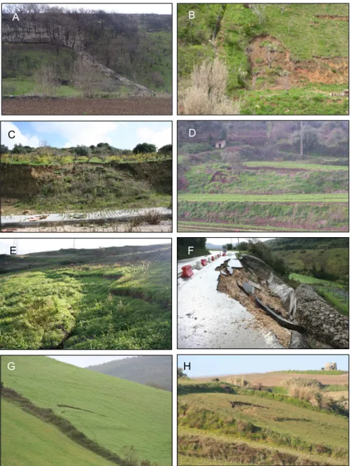
21), with failure depth lower than 1.5 m, including 13 shal-low translational slides, 2 shalshal-low rotational slides, and 3 de-bris flows shifted from shallow landslides (Table 2). Individ-ual examples of these shallow landslides can be appreciated in Fig. 7. Additionally, there were also 3 rotational slides with slip surface deeper than 1.5 m. Landslides distribute mostly on the sedimentary formations of Upper Jurassic age (Table 3, Fig. 2): 12 cases, 57% of total registered landslides. 4.2 The 25–27 October 2006 event
Rainfall occurrence was observed to be close to average dur-ing the first month of the 2006–2007 climatological year (38 mm in September, 8 mm above the monthly average). However, October registered 240 mm, i.e. 2.7 times the cor-responding monthly average. Figure 4b illustrates the evo-lution of antecedent rainfall for different durations (1 to 60 days) at S. Juli˜ao do Tojal from September 2006 to April 2007. The precipitation was very intense during the second half of October; in this period, daily rainfall surpassed 25 mm in four distinct occasions, and the yearly maximum was ob-served on the 25 October (69.3 mm). The critical rainfall conditions for the landslide event were found to be 218.5 mm
in 10 consecutive days (Table 2). The corresponding rainfall intensity was 22 mm/day, and the return period of the precip-itation event is 10.1 years. The maximum cumulative rainfall was observed in the Montejunto Mountain and in the Loures area (Fig. 5b), and most landslides distribute in areas where the 10-days cumulative rainfall was above 200 mm.
This event includes two distinct periods, a short and mod-erate rainy burst, followed by a torrential rainfall episode in the Lisbon area. This later torrential episode began at noon on the 24 October and finished in the early morning of the following day, corresponding to a total duration of just 18 h. The total rainfall registered for this episode exceeded 69 mm in S. Juli˜ao do Tojal, and 88 mm in Penedos de Alenquer, located in the south flank of the Montejunto Mountain (164 m a.s.l).
C D
Fig. 6. The Cut-off low (COL) system affecting the Portuguese area, 17–18 March 2006. (A)sea level pressure (hPa, lines) and air
temperature at 500 hPa (in◦C, colours), 17 March, 00:00 p.m.;(B)sea level pressure (hPa, lines) and 500 hPa geopotential heights (metres,
colours), 18 March, 00:00 p.m.;(C)and(D)convective precipitation rate (mm/day) on 17 March (00:00 p.m.) and 18 March (06:00 a.m.),
respectively. Source: Reanalysis-2 data.
warm and moist air from the SW, contributing to the estab-lishment of an instability band. Several convective cloud sys-tems embedded in this band have caused thunderstorms pro-ducing intense rainfall over small areas. Figure 8 (b, c and d) illustrates the sequence of convective precipitation rate ob-tained for three moments separated by 6 h. This sequence clearly shows that the region just north of Lisbon was par-ticularly affected by the precipitation associated with these convective cells.
Six shallow soil slips were triggered during the 25–27 Oc-tober event (Table 3, Fig. 2). Three slope movements af-fected basalts and volcanic tuffs belonging to the Upper
Cre-taceous Volcanic Complex of Lisbon (Fig. 7) and the remain-ing distribute on Palaeogene, Albian-Cenomanian, and Up-per Jurassic sedimentary formations.
4.3 The 28 November 2006 event
Table 3.Landslide incidence on lithological units (number of slope movements) for landslide events in the Lisbon region during 2006 (SL – shallow landslides; DL – deep landslides).
2006 landslide events
Lithological Unit 20 Mar 2006 25/27 Oct 2006 28 Nov 2006
Total (%)
SL DL SL DL SL DL
Holocene alluvium
Quaternary terrace and dune deposits Pliocene sandstones
Miocene limestones and sandstones
Palaeogene conglomerates, sandstones and limestones 4 1 1 1 7 13.7
Upper Cretaceous volcanic complex of Lisbon 1 1 3 5 9.8
Upper Cenomanian limestones
Albian-Cenomanian marls and marly limestones 1 1 1 4 1 8 15.7
Lower Cretaceous sandstones 3 3 5.9
Lower Cretaceous limestones
Upper Jurassic sandstones, conglomerates and clays 8 1 6 6 21 41.2
Upper Jurassic marls, clays and limestones 3 1 2 6 11.8
Middle Jurassic limestones Lower Jurassic marls
Granite, syenite and gabbro 1 1 2.0
Basaltic intrusions
Total 18 3 6 16 8 51 100.0
the selected period was higher than the winter average, corre-sponding to roughly two-thirds of the MAP. The correspond-ing rainfall intensity was 11 mm/day, and the return period of the precipitation event is 8.2 years. The 40-days cumulative rainfall was abundant along a SW-NE direction zone where most landslides were observed (Fig. 5c). Like for the Octo-ber episode, the maximum rainfall was verified in two spots within that zone: the Montejunto Mountain and the Loures area (Fig. 5c).
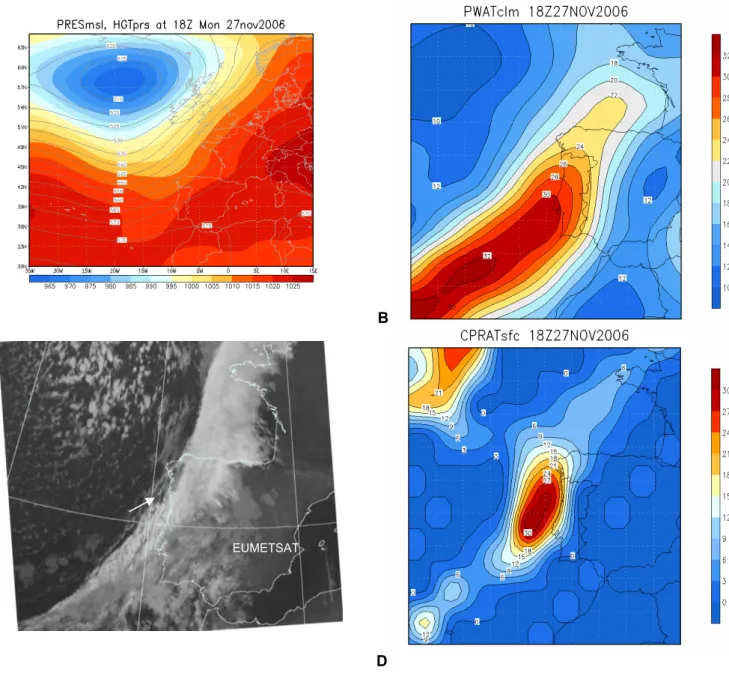
In addition to the antecedent rainfall conditions, this land-slide event is associated with a wet spell occurred between the 23 and 28 November. In this period the mid and upper-level circulation was dominated by intense westerlies over the Eastern Atlantic, conditioning the activity of frontal lows moving into the European shores. Two major rainstorms were caused by similar synoptic circulation conditions, and, for both rainy episodes, the origin of rainfall was closely linked with the activity of cold fronts. Here we have concen-trated our analysis on the second rainstorm (27–28 Novem-ber), because this episode contributed more decisively to trig-ger the landslide event. The most relevant features of the at-mospheric circulation for the low and mid tropospheric lev-els are shown in Fig. 9a. We present also the correspond-ing infra-red meteosat image (MSG-IR), illustratcorrespond-ing the pres-ence of the cold front cloud system on the 27 November (at 06:00 h), precisely before reaching the Lisbon region (Fig. 9c). The active cold front system crossed the Por-tuguese territory from the SW to the NE during the late af-ternoon and the night of the 27 and at the daybreak of the 28
November. On the 27 November (18:00 h), the high moisture content of the air mass moving into Portugal is confirmed by the peak values of precipitable water (above 30 mm) ori-ented with a SW-NE axis (Fig. 9b). Consequently several convective cloud systems were formed near western Iberia (Fig. 9c), producing abundant rainfall over large areas of Por-tugal (Fig. 9d). The Lisbon area was affected by intense showers, with immediate consequences for landslide activ-ity, taking into account the antecedent precipitation observed in the previous weeks.
The 28 November event triggered 24 individual landslides (Figs. 1 and 6), including 7 rotational and 1 translational slides with deep slip surfaces. Thus this event produced, on average, deeper landslides than the corresponding slope movements described previously for late October. The re-maining 16 landslides are soil slips (shallow translational slides, 13 cases; shallow rotational slides, 3 cases). The ma-jority of landslides registered in November 2006, including 6 deep slope movements, distribute on sedimentary formations of Upper Jurassic age (Table 3, Fig. 2). Other lithological units affected by slope instability during this event are the Palaeogene, Albian-Cenomanian and Lower Cretaceous sed-imentary formations.
5 Validation of rainfall thresholds
A B
C D
E F
G H
Fig. 7. Landslides triggered by rainfall in 2006 in the Lisbon Region. (A)debris flow occurred in Bucelas (20 March 2006);(B)and(C)
shallow soil slips occurred near Arruda dos Vinhos (20 March 2006);(D)shallow rotational slide occurred near Loures (27 October 2006);
(E)translational slide occurred in Enxara (28 November 2006);(F)rotational slide occurred in Alrota (28 November 2006);(G)and(H)
shallow soil slips occurred near Torres Vedras (28 November 2006).
models regarding rainfall amount/duration previously fit for the study area (Sect. 3). Only this type of application to independent data (i.e. not used in any way during the cal-ibration process) will allow us to validate regional rainfall thresholds for landslide activity. Figure 10 shows the re-gression line between the critical cumulative rainfall amount and the corresponding rainfall event duration for 19 landslide events occurred between 1956 and 2005. We plot on this fig-ure the three landslide events observed in 2006, and all of them fall above the threshold defined by the regression model (Cr=7.4D+107, deduced previously in Trigo et al., 2005).
(a) (b)
(c) (d)
Fig. 8.The frontal cyclone affecting the Portuguese area, 25 October 2006.(a)Sea level pressure (hPa, colours) and 500 hPa geopotential
heights (decametres, lines); (b, candd) convective precipitation rate (mm/day) over the Portuguese area on the 24 October, 12:00, 18:00,
and the 25 October, 00:00. Source: Reanalysis-2 data.
Figure 11a also shows a landslide event occurred in January 2001 that was described in previous works (Zˆezere and Ro-drigues, 2002; Trigo et al., 2005; Zˆezere et al., 2005). From January 2001 to March 2006 the regional rainfall threshold was never reached, and simultaneously, no landslide activity was reported for the Lisbon region during this period. There-fore, from 2001 to 2007, our model did not predict landslide events that did not occur (i.e. “false positives”), and there is no evidence of unpredicted landslide events (i.e. “false nega-tives”).
A
B
C D
EUMETSAT
Fig. 9. The frontal cyclone affecting the Portuguese area, 27 November 2006 (18:00 h).(A)sea level pressure (hPa, colours) and 500 hPa
geopotential heights (decametres, lines);(B)precipitable water (mm); (C)Infrared (10.8µm) meteosat image, with an arrow indicating
the front track path over Portugal;(D)convective precipitation rate (mm/day). Sources: Reanalysis-2 data (A, B and D); Meteosat images
archive, British Atmospheric Data Center (C).
Fig. 12 we can confirm that the 2006 events fall above those thresholds defined by the combination of the daily rainfall and theCARfor 5, 10, 15 and 30 days. The single excep-tion to this rule corresponds to the 30 daysCARfor the 28 November event.
6 Relationships with the North Atlantic Oscillation
Table 4.Calibrated antecedent rainfall (CAR) for periods of landslide activity in the Lisbon region during 2006.
Calibrated antecedent rainfall (CAR)
Landslide event
Date Daily
Rainfall (mm)
5 days
10 days
15 days
30 days
# of previous consecu-tive days with 30-days
CAR>50 mm
2006-A 20-03-06 42.1 89.6 89.7 95.9 107.4 2
2006-B 27-10-06 26.0 99.1 126.8 131.4 132.1 6
2006-C 28-11-06 36.5 58.0 62.8 74.5 79.6 3
Table 5. Monthly values of the NAO index obtained from the Climatic Research Unit (CRU). The three months in 2006 characterised by landslides occurrence are highlighted in grey cells.
Jan Feb Mar Apr May Jun Jul Aug Sep Oct Nov Dec
2005 +1.82 −2.25 −1.29 +0.71 −0.13 −1.00 −0.08 +0.94 +0.50 −0.45 −1.01 −0.81
2006 −1.24 −0.10 −1.12 +0.57 −0.22 −0.41 +0.83 −2.47 −1.02 −1.97 +1.70 +3.08
Having shown in previous works that the winter precipita-tion Iberia is largely associated with the NAO mode (Trigo et al., 2004, 2005) we will now concentrate on the precipitation that is measured at the rain gauge station located closer to the landslide events. For this purpose we use all the available monthly rainfall from November to March, at S. Juli˜ao To-jal, between 1939 and 2007. The inter-annual variability of this enlarged winter (NDJFM) precipitation and correspond-ing winter NAO index can be observed, for the 1932–2007 period in Fig. 13. It should be noticed that both curves (pre-cipitation and NAO index) were normalized and the NAO in-dex multiplied by minus one to facilitate visual comparisons. The correlation coefficient between both curves isR=−0.65 (statistically significant at the 1% level). This figure also puts into evidence that the vast majority of landslide events have occurred with higher than usual winter precipitation, and si-multaneously with lower than average winter NAO index.
Finally we have analyse the role played by the NAO dur-ing (and prior to) those months of 2006 marked by landslide activity. Table 5 shows the monthly values of the NAO in-dex available from the CRU website for the years 2005 and 2006, where we have highlighted in grey the three months of 2006 characterised by landslide activity in the Lisbon re-gion. It should be noticed that prior to the March 2006 event, the winter of 2005–2006 was characterised by 5 consecutive months with NAO<0, while the October (November) event was preceded by two (three) months with very low NAO val-ues. Moreover, two of the months characterised by slope in-stability, namely March and October 2006, also present sig-nificantly negative NAO values. The only case where this is not observed corresponds to November 2006, where the observed positive monthly NAO value appears to contradict the general rule. In any case it should always be stressed that the three previous months (August–September–October)
y = 7,4296x + 107,17 R2 = 0,9437
0 100 200 300 400 500 600 700 800 900
0 10 20 30 40 50 60 70 80 90 100
consecutive days
R
a
in
fa
ll (
mm)
No landslides Shallow landslides Deep landslides Trend (landslides)
A B
C
Fig. 10.Regression line between critical cumulative rainfall amount and corresponding rainfall event duration. Diamonds: values asso-ciated to shallow landslide events; Triangles: values assoasso-ciated to deep landslide events; Small grey dots: values obtained from the yearly cumulative rainfall values, and maximum rainfall intensity for all duration intervals (computed for years without reported land-slides).Landslide events occurred in 2006 are marked in red: A – 20 March 2006; B – 27 October 2006; C – 28 November 2006.
were all characterised by negative NAO values and strong positive precipitation anomalies.
7 Concluding remarks
J. L. Z ˆezere et al.: Rainf all-trigg ered landslides occurred in the Lisbon re gion o v er 2006 (a) -4 0 -2
0 0 20 40 60 80
10 0 12 0 01-09-2000 01-09-2001 01-09-2002 01-09-2003 01-09-2004 01-09-2005 01-09-2006 Rainfall (mm)
B
C
(b) -4 0 -20 0 20 40 60 80
100 120 01-09-05 11-09-05 21-09-05 01-10-05 11-10-05 21-10-05 31-10-05 10-11-05 20-11-05 30-11-05 10-12-05 20-12-05 30-12-05 09-01-06 19-01-06 29-01-06 08-02-06 18-02-06 28-02-06 10-03-06 20-03-06 30-03-06 09-04-06 19-04-06 29-04-06 Rainfall (mm) (c) -4 0 -2
0 0 20 40 60 80
A
y = 516.08x-0.9343
0 20 40 60 80 100 120 140 160 180
0 20 40 60 80 100 120 140
3-days calibrated antecedent rainfall (mm)
D a ily r a in fa ll (m m ) A B C
y = 167.28e-0.0355x
0 20 40 60 80 100 120 140 160 180
0 20 40 60 80 100 120 140
5-days calibrated antecedent rainfall (mm)
D a ily r a in fa ll (m m) A B C 85 16
A
B
A
y = 1356.8x-0.9455
0 20 40 60 80 100 120 140 160 180
0 20 40 60 80 100 120 140
10-days calibrated antecedent rainfall (mm)
D ai ly rai nf a ll (m m ) A B C 85 16 A
A
B
y = 4163.4x-1.1929
0 20 40 60 80 100 120 140 160 180
0 20 40 60 80 100 120 140 160
15-days calibrated antecedent rainfall (mm)
D a ily r a in fa ll ( mm) A B C 85 16
C
A 0 20 40 60 80 100 120 140 160 1800 20 40 60 80 100 120 140 160
30-days calibrated antecedent rainfall (mm)
D a ily r a in fa ll ( mm) 85 16 A B C
D
Fig. 12.Relationship between daily rainfall and calibrated antecedent rainfall (CAR) in 5 days(A), 10 days(B), 15 days(C)and 30 days (D). Diamonds: values associated to shallow landslides occurrence; Triangles: values associated to deep landslides occurrence; Small grey
dots: values obtained from the yearly maximum daily rainfall and from the yearly maximumCAR, computed for years without reported
landslides; Landslide events occurred in 2006 are marked in red: A – 20 March 2006; B – 27 October 2006; C – 28 November 2006.
In 2006, three new rainfall-triggered landslide events oc-curred in the Lisbon region, namely on the 20 March, the 25– 27 October, and the 28 November. During these three events we have identified about 51 individual slope movements that spread over a geographical area larger than 1400 km2 (from Lisbon to the south flank of the Montejunto Mountain). These individual slope movements were characterised by dif-ferent lithological, morphological and land cover conditions. The 20 March event comprises 21 individual landslides, es-sentially shallow slope movements (86% of total landslides), which concentrate mostly on the sedimentary formations of Upper Jurassic age (57% of total registered landslides). The 25–27 October event includes 6 shallow soil slips, half of them occurred on basalts and volcanic tuffs belonging to the Upper Cretaceous Volcanic Complex of Lisbon. Finally, the 28 November 2006 event encompasses 24 individual land-slides, including 7 rotational and 1 translational slides with deep slip surfaces. About half of these landslides concentrate on sandstones, conglomerates and clays of Upper Jurassic age.
The comparison between critical rainfall distribution and landslide incidence for the landslide events observed in 2006 led us to conclude that landslides have not clustered around those areas where the maximum rainfall was registered. Ad-ditionally, the spatial distribution of landslides, although in-fluenced by the rainfall distribution, is controlled by the loca-tion of particular lithological units. Therefore, these results
prove that excessive rainfall alone is not sufficient to trigger landslides on stable slopes, confirming the importance of the geological background as predisposing factor for slope insta-bility. The landslide incidence observed in the Lisbon area in the last 50 years allows us to identify the Upper Cretaceous Volcanic Complex of Lisbon, the Albian-Cenomanian marls and clays, and the Upper Jurassic sandstones, conglomerates, marls, clays and limestones, as the most important landslide-prone lithological units in the study area. From this perspec-tive, the slope instability events verified in 2006 are found to be in accordance with this observation, because 78% of the total registered landslides concentrate within these lithologi-cal units.
Figure 13
Fig. 13.Inter-annual variability of the mean winter (NDJFM) pre-cipitation at S. Juli˜ao Tojal (solid curve), and the corresponding
winter NAO index, multiplied by−1 to facilitate analysis (dashed
curve); both curves have been normalised and so are dimension-less (period 1932–2007). Diamonds – events of shallow landslides activity; Triangles – events of deep landslides activity.
(11 mm/day), which produced some deep failures (e.g. rota-tional slides), associated to the steady rise of the groundwater table.
We have characterised in detail the short and long-term atmospheric circulation conditions that were responsible for the trigger of landslide events. It was shown that the three events correspond to considerably different synoptic atmo-spheric patterns, with the March event being associated to an intense cut-off low system and the October and Novem-ber events related to more typical Atlantic low pressure sys-tems (and respective fronts) travelling eastwards. It should be stressed that, different synoptic atmospheric patterns are able to generate relatively similar critical rainfall conditions (amount – duration) in the study area, therefore we did not find a unique connection between the synoptic atmospheric circulation and landslide activity.
Furthermore, we have analysed the role exerted by the North Atlantic Oscillation (NAO) during those months marked by landslide activity in order to establish possible relationships between this pattern of atmospheric circulation variability in the Northern Hemisphere and regional slope in-stability events. We have shown that the March event was preceded by 5 consecutive months with very low NAO val-ues, while the October and November events were preceded, respectively, by 2 and 3 months with considerably negative values of NAO. Additionally, the NAO index was signif-icantly negative during the months of the two first events (March and October 2006), and the single exception to this rule corresponds to November 2006. Nevertheless, despite the positive NAO value verified in November, this month was
preceded by a long period (three months) with consistently NAO values below−1.0. This result confirms what has been found by the authors on the pre-conditioned role played by consecutive months of negative NAO index (usually associ-ated with positive precipitation anomalies) for a large num-ber of landslide events in the study area (Trigo et al., 2005; Zˆezere et al., 2005).
The critical rainfall values corresponding to landslide events occurred in 2006 were compared with the pre-established regression models regarding rainfall amount – duration, in order to validate regional rainfall thresholds. It was found that landslide events verified in 2006 fall above the threshold corresponding to the regression model between the critical cumulative rainfall amount and the corresponding rainfall event duration for 19 landslide events occurred from 1956 to 2005 (i.e.y=7.4x+107). Moreover, the reliability of this regression rule, as regional rainfall threshold, is con-firmed by the inexistence of both “false positives” and “false negatives” during the period from January 2001 to March 2006.
We have proved that landslide events occurred in 2006 also fit regional thresholds defined by the combination of the daily rainfall and the calibrated antecedent rainfall (CAR) for 5, 10, 15 and 30 days, although an exception to this rule was observed for the 30-daysCARcorresponding to the 28 November landslide event. This result may be explained by a limitation of the objective rule adopted, but it is possible that the exception is explained by the method used to derive the calibrated antecedent rainfall. In fact, the adoption of a constantK=0.9 might be a choice too drastic as it makes negligible all the rainfall that has occurred prior to 30 days before a landslide event. Therefore, as it stands,CARmay not be the most suitable index to characterize landslide events associated to rainfall periods longer than 30 days, as was the case of the 28 November event.
We acknowledge that results obtained here need to be fur-ther confirmed in the near future, when furfur-ther landslides events take place in the Lisbon area. In the meantime, we are confident that the validation exercise presented here is very promising for landslide risk mitigation purposes. In fact, the availability of daily rainfall records in near real time allows the automatic computation of the minimum daily rainfall needed to reach the precipitation triggering threshold, and therefore, the implementation of a regional landslide warn-ing system.
Technology and Higher Education. The authors are thankful to R. Van Beek, D. Hantz and to an anonymous reviewer for their comments and suggestions that improved the quality of this paper.
Edited by: F. Catani
Reviewed by: D. Hantz, R. Van Beek, and another anonymous referee
References
Aleotti, P.: A warning system for rainfall-induced shallow failures, Eng. Geol., 73, 247–265, 2004.
Caine, N.: The rainfall intensity–duration control of shallow land-slides and debris flows, Geogr. Ann., 62, 1–2, 23–27, 1980. Corominas, J.: Landslides and climate, Keynote Lectures from the
8th International Symposium on Landslides, 4, 1–33, 2001. Crozier, M.: Landslides: causes, consequences and environment,
Croom Helm, London, 1986.
Daveau, S., Coelho, C., Costa, V. G., and Carvalho, L.: R´epartition et rythme des pr´ecipitations au Portugal, Mem´orias do Centro de Estudos Geogr´aficos, 3, Lisboa, 1977.
D’Orsi, R., D’Avila, C., Ortig˜ao, J. A., Dias, A., Moraes. L., and Santos, M. D.: Rio-Watch: the Rio de Janeiro landslide watch system, Proc. 2nd PSL Pan-AM Symposium on Landslides, Rio de Janeiro, 1, 21–30, 1997.
Ferreira, D. B.: Carte Geomorphologique du Portugal, Mem´orias do Centro de Estudos Geogr´aficos, Lisboa, 6, 1981.
Fukuoka, M.: Landslides associated with rainfall, Geotech. Eng., 11, 1–29, 1980.
Gimeno, L., Trigo, R. M., Ribera, P., and Garcia, J. A.: Editorial: Special issue on cut-off low systems (COL)”, Meteorol. Atmos. Phys., 96, 1–2, doi:10.1007/s00703-006-0216-5, 2007.
Gostelow, P.: Rainfall and landslides, in: Prevention and control of landslides and other mass movements, edited by: Almeida-Teixeira, M., Fantechi, R., Oliveira, R., and Gomes Coelho, A., CEC, Bruxels, 139–161, 1991.
Gumbel, E. J.: Statistics of extremes, Columbia University Press, New York, 1958.
Guzzetti, F., Peruccacci, S., Rossi, M., and Stark, C. P.: Rainfall thresholds for the initiation of landslides in central and southern Europe, Meteorol. Atmos. Phys., doi:10.1007/s00703-007-0262-7, 2007.
Iverson, R. M.: Landslide triggering by rain infiltration, Water Re-sour Res., 36, 1897–1910, 2000.
Keefer, D. K., Wilson, R. C., Mark, R. K., Brabb, E. E., Brown, W. M., Ellen, S. D., Harp, E. L., Wieczorek, G. F., Alger, C. S., and Zatkin, R. S.: Real-time landslide warning during heavy rainfall, Science, 238, 921–925, 1987.
Kulberg, M. C. and Kulberg, J. C.: Tect´onica da regi˜ao de
Sintra.Tect´onica das regi˜oes de Sintra e Arr´abida, Mem. Geociˆencias, Museu Nac. Hist. Nat. Univ. Lisboa, 2, 1–34, 2000.
Nieto, R., Gimeno, L., De la Torre, L., Ribera, P., Barriopedro, D., Garc´ıa-Herrera, R., Serrano, A., Gordillo, A., Reda˜no, A., and Lorente, J.: Interannual variability of Cut-off-low systems over the European sector: The role of blocking and the North-ern Hemisphere circulation modes, Meteorol. Atmos. Phys., 96, 85–101, 2007.
Paredes, D., Trigo, R. M., Garcia-Herrera, R., and Trigo, I. F.: Understanding precipitation changes in Iberia in early Spring: weather typing and storm-tracking approaches, J. Hidrometeo-rol., 7, 101–113, 2006.
Polemio, M. and Petrucci, O.: Rainfall as a landslide triggering factor: an overview of recent international research, in: Land-slides in Research, Theory and Practice, edited by: Bromhead, E., Dixon, N., and Ibsen, M., London, Thomas Telford, 1219– 1226, 2000.
Ribeiro, A., Antunes, M. T., Ferreira, M. P., Rocha, R. B. , Soares, A. F., Zbyszewski, G., Almeida, F. M., Carvalho, D., and Mon-teiro, J.H.: Introduction `a la g´eologie g´en´erale du Portugal, Servic¸os Geol´ogicos de Portugal, Lisboa, 1979.
Trigo, R. M., Pozo-V´azquez, D., Osborn, T. J, Castro-D´ıez, Y., G´amiz-Fortis, S. and Esteban-Parra, M. J.: North Atlantic Oscil-lation influence on precipitation, river flow and water resources in the Iberian Peninsula, Int. J. Climatol., 24, 925–944, 2004. Trigo, R. M., Zˆezere, J. L., Rodrigues, M. L., and Trigo, I. F.: The
influence of the North Atlantic Oscillation on rainfall triggering of landslides near Lisbon, Nat. Hazards, 36, 331–354, 2005. Van Asch, T., Buma, J., and Van Beek, L.: A view on some
hy-drological triggering systems in landslides, Geomorphology, 30, 25–32, 1999.
Wieczorek, G. F.: Landslides triggering mechanisms, in: Land-slides: Investigation and Mitigation, edited by: Turner, A. K. and Schuster, R. L., National Research Council, Transportation Research Board, Washington, 76–90, 1996.
Zˆezere, J. L.: Rainfall triggering of landslides in the Area North of Lisbon, in: Landslides in Research, Theory and Practice, edited by: Bromhead, E., Dixon, N., and Ibsen, M., London, Thomas Telford, 3, 1629–1634, 2000.
Zˆezere, J. L., Ferreira, A. B., and Rodrigues, M. L.: Landslides in the North of Lisbon Region (Portugal): Conditioning and Trig-gering factors, Phys. Chem. Earth, 24, 925–934, 1999.
Zˆezere, J. L. and Rodrigues, M. L.: Rainfall Thresholds for Lands-liding in Lisbon Area (Portugal), in: Landslides, edited by: Ry-bar, J., Stemberk, J., and Wagner, P., A. A. Balkema, Lisse, 333– 338, 2002.
Zˆezere, J. L., Trigo, R. M., and Trigo, I. F.: Shallow and deep land-slides induced by rainfall in the Lisbon region (Portugal): assess-ment of relationships with the North Atlantic Oscillation, Nat. Hazards Earth Syst. Sci., 5, 331–344, 2005,