Kohei Arai
11Graduate School of Science and Engineering Saga University
Saga City, Japan
Masanori Sakashita
11Graduate School of Science and Engineering Saga University
Saga City, Japan
Abstract—Cirrus cloud detection accuracy of GOSAT/CAI and Landsat-8 is evaluated with a ground based Laser Radar: Lidar data and sky view camera data. Also, the evaluation results are confirmed with Calipso data together with a topographic representation of vertical profile of cloud structure. Furthermore, origin of cirrus clouds is estimated with forward trajectory analysis. The results show that GOSAT/CAI de4rived cirrus clouds is not accurately enough due to missing of cirrus cloud detection spectral channel while Landsat-8 derived cirrus cloud.
Keywords—Cirrus cloud; GOSAT/CAI; Landsat; LiDAR; Sky view camera; Calipso; topogramphic representation of 3D clouds
I. INTRODUCTION
Cloud detection is one of though issues in satellite remote sensing in particular for cirrus clouds [1]-[16]. It is not so easy to detect cirrus clouds in particular for remote sensing satellite onboard instruments. In order to detect cirrus clouds, 1.38 micrometer wavelength channel is adopted for Moderate resolution of Imaging Spectrometer: MODIS1 and Landsat-8 Operational Land Imager: OLI 2 , etc. Green house gasses Observation Satellite / Cloud and Aerosol Imager: GOSAT 3 /CAI 4 is dedicated sensor for cloud and aerosol retrievals. Because that GOSAT/FTS (Fourier Transform Spectrometer 5 ) data is affected by clouds and aerosols, GOSAT/CAI is carried on the same platform of GOSAT satellite. Therefore, cloud flag and its confidence level are evaluated from the GOSAT/CAI and provide as Level 2 of GOSAT products together with Level 1B product as a source of Level 2 product. As mentioned above, it is not so easy to detect cirrus clouds. Although cirrus detection wavelength channel (1.38 micrometer) is required for detection of cirrus clouds, GOSAT/CAI does not have such channel. Therefore, it is not possible to detect cirrus cloud essentially. On the other hand, Landsat-8/OLI has cirrus detection channel. It is expected that cirrus detection can be done with Landsat-8 OLI data. Thus, cirrus cloud screening can be done for GOSAT/FTS observations.
In order to check the capability of cirrus cloud detection,
1http://modis.gsfc.nasa.gov/ 2 http://landsat.usgs.gov/landsat8.php 3 http://www.gosat.nies.go.jp/
4 http://www.gosat.nies.go.jp/eng/gosat/page2.htm
5 https://en.wikipedia.org/wiki/Fourier_transform_infrared_spectroscopy
Light Detection and Ranging、Laser Imaging Detection and Ranging: LiDAR data which allows measurement of back scattering ratio and depolarization ratio is used [17]-[29]. The ground based LiDAR is equipped at one of the GOSAT validation sites which is situated at Saga University, Japan. Therefore, vertical profile of aerosol particles as well as cloud particles are detected which results in detection of aerosols and clouds including cirrus clouds. Meantime, sky view camera observes hemispherical cloud conditions. Although it is possible to detect thick clouds, it is not easy to detect cirrus clouds with sky view camera. Vertical cloud structure can be retrieved with Cloud Aerosol Lidar and Infrared Pathfinder Satellite Observations: Calipso6 data. Therefore, detected cirrus clouds can be validated with Calipso data. In this paper, a specific representation of vertical cloud structure is proposed. That is to representation of the retrieved structure on the topographic map which is projected on the globe. Forward trajectory analysis is also made for retrievals of the original source areas of the cirrus in concern through consideration of atmospheric conditions.
In the next section, the proposed method for evaluation of cirrus detection accuracy of GOSAT/CAI and Landsat-8 is described followed by experiments (method and procedure as well as the results from the experiments). Then validation of the evaluation results with sky view camera data and Calipso data is described followed by the specific representation of vertical cloud structure on the earth. Finally, conclusion and some discussion are followed.
II. METHOD AND PROCEDURE
A. GOSAT/FTS and CAI
GOSAT satellite is operating since January 23 2009 as the joint project among Ministry of Environment, JAXA and National Institute Environmental Science: NIES. GOSAT carries FTS and CAI as mission instruments as shown in Fig.1.
Major mission of GOSAT is to measure total column of carbon dioxide and methane which can be done with FTS instrument. In order to avoid influence due to aerosols and clouds, TANSO/CAI is also carried on GOSAT.
Fig. 1. Mission instruments onboard GOSAT satellite
B. GOSAT Validation Site
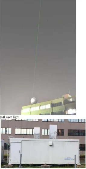
There are TCCON validation sites in the world. One of these is Saga University site in Japan. The location is shown in Fig.2. Fig.3 shows the LiDAR site (Laser light and the container in which LiDAR is equipped).
Fig. 2. Saga University TCCON site for GOSAT validation
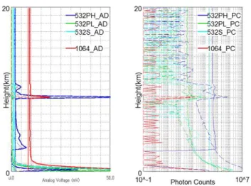
Examples of the LiDAR data are shown in Fig.4 (a) together with PM2.5 data, CAI imagery data, the time series of PM2.5 data, and the sky view camera image. The right bottom graphs are the LiDAR data which is acquired at 14:00 Japan Standard time on May 29 2014. On the left, there is back scattering ratio data is situated while depolarization ratio is shown on the right. From these back scattering ratio and depolarization ratio, aerosol distribution and cloud vertical profile can be retrieved. Therefore, LiDAR data derived cloud vertical profile can be used for validation of CAI data derived clouds and Landsat-8 data derived clouds in particular, cirrus clouds. Meanwhile, Fig.4 (b) shows the LiDAR data which is acquired on April 26 2015. There is a peak of back scattered photon counts at around 10km of elevation (altitude above sea level). It is cirrus clouds. There is the ground based FTS for GOSAT validation which is situated just beside the LiDAR as shown in Fig.5. Other than these, there are sky view camera, sky radiometer which allows estimation of aerosol particle size distribution and refractive index retrievals for GOSAT validation. Examples of sky camera imagery data are shown in Fig.6 ((a) is for clear sky while (b) is for cloudy sky).
(a)Laser light
(b)Container
Fig. 3. LiDAR at Saga University GOSAT validation site
(b)LiDAR data
Fig. 4. Examples of the LiDAR data together with the other measured data
Fig. 5. Ground based FTS for GOSAT validation
(a)Clear sky (b)Cloudy sky
Fig. 6. Examples of sky view camera data
C. Cloud Products Derived from CAI
There are two Level 2 cloud products, Cloud flag with 0 or 1 and Confidence level ranged from 0 to 1. Fig.7 shows lower and upper limits of clouds and clear sky. Using these definitions, four statistical tests are applied to the CAI data as shown in equation (1).
Fig. 7. Definition of lower and upper limits
Band2R +0.195 +0.045
Band3R /Band2R
Smaller END LARGER END
0.9 1.1
0.66 1.7
NDVI Smaller END LARGER END
-0.1 0.22
-0.22 0.46
Band3R
/Band4R 1.06 0.86
D. GOSAT/CAI and Landsat-8 Imagery Data
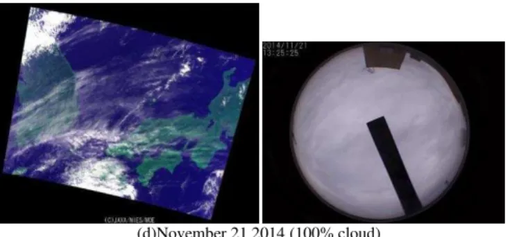
Fig.8 shows examples of the acquired color images of GOSAT/CAI imagery data together with sky view camera images which area acquired at the Saga University validation site at the same time as satellite over pass time.
(a)April 1 2014 (No cloud)
(b)July 30 2014 (No cloud)
(d)November 21 2014 (100% cloud)
Fig. 8. Examples of GOSAT/CAI images and the sky view camera images at the Saga University validation site at the satellite over pass time
III. EXPERIMENTS
A. Match-Up Data Between CAI and LiDAR as well as
Landsat-8 OLI
In order to evaluate cirrus detection capability of CAI and Landsa-8 OLI, match-up data have been searched for the term of the first half year of 2015. As the results from the search, the following two data are found,
January 20 April 26
CAI and Landsad-8 OLI images of the match-up data on January 20 2015 are shown in Fig.9 while those for April 26 2015 are shown in Fig.10.
(a)Cirrus detected image from Landsat-8 OLI
(b)Landsat-8 OLI image
(c)CAI image
(d)Sky view image
(e)LiDAR data
Fig. 9. Match-up data on January 20 2015
(a)Cirrus detected image from Landsat-8 OLI
(b)Landsat-8 OLI image
(c)CAI image
(d)Sky view camera image
(e)LiDAR data
Fig. 10.Match-up data on April 26 2015
(d) shows sky view camera image while (e) shows LiDAR back scattered photon count data as the function of altitude. It is quite obvious that there is no cirrus cloud on January 20 2015 while there are cirrus clouds on April 26 2015. Green colored areas or pixels in (b) Landsat-8 OLI images indicate cirrus clouds.
Although Landsat-8 OLI image shows the cirrus clouds pixels in Fig.10 (b), Fig.10 (c) does not indicate any cirrus cloud at all. On the other hand, LiDAR data shows evidence of cirrus cloud existing as shown in Fig.10 (e). Therefore, it may say that Landsat-8 band 9 of cirrus channel does work to detect cirrus cloud while GOSAT/CAI does not work for detection of cirrus cloud due to missing cirrus channel.
B. Adjectment of Acquisition Time Difference Between
Landsat-8 and GOSAT
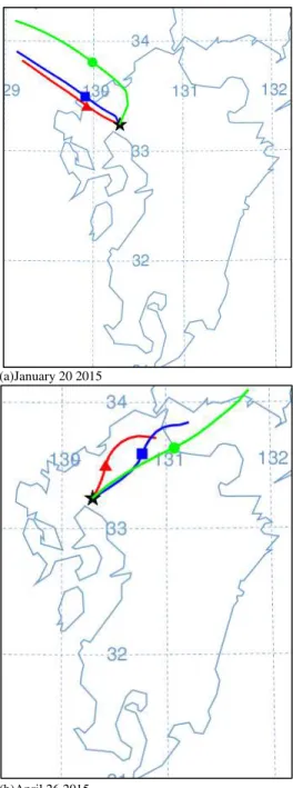
Local mean times of the orbits of Landsat-8 and GOSAT are different each other for 30 minutes. Therefore, some adjustment of the time difference between both is required. By using forward trajectory analysis software tool provided by NOAA, original positions of cirrus cloud (30 minutes before the acquisition time) are estimated. The results from the forward trajectory analysis are shown in Fig.11. For January 20 2015, there is North-West wind while there is North-East wind for April 26 2015.
(a)January 20 2015
(b)April 26 2015
Fig. 11.Results from forward trajectory analysis
C. Summary of the Experimental Results
LiDAR data are acquired for 173 days within 518 days from April 1 2014 to August 31 2015 (Revisit cycle of the GOSAT satellite is 3 days). Within 173 days, LiDAR data are acquired 48 days (Acquisition ratio of LiDAR data to the total available days is just 33.01%). Cirrus clouds are observed for 11 days out of 48 days. Meanwhile, cirrus clouds are detected with CAI for just 8 days out of 11 days. On the other hand, cloud free situations are found with CAI for 18 days out of 37 days which is confirmed with LiDAR data. Due to the fact that the revisit cycle of Landsat-8 satellite is 16 days, just two match-up data between LiDAR and Landsat-8 OLI are collected for check cirrus detection accuracy. Two of
match-up data show good coincidence between Landsat-8 OLI data utilized cirrus detection (no cirrus cloud and cirrus cloud existing situations).
D. Another Comparison Between Landsat-8 OLI data and
GOSAT/CAI Imagery Data
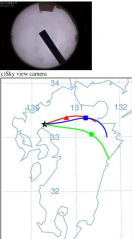
Another match-up data between Landsat-8 OLI and GOSAT/CAI imagery data is found for April 7 2014 (Unfortunately LiDAR data is not acquired on that day). Fig.12 (a) shows GOSAT/CAI imagery data, (b) shows Landat-8 OLI imagery data on that day. Meanwhile, Fig.12 (c) shows the sky view camera image while (d) shows the results from the forward trajectory analysis for adjustment of the data acquisition time difference of 30 minutes between GOSAT/CAI and Landsat-8 OLI data.
(a)GOSAT/CAI
(c)Sky view camera
(d)Results from forward trajectory analysis
Fig. 12.Another match-up data between GOSAT/CAI and Landsat-8 OLI
Although GOSAT/CAI cloud product indicates there are cirrus clouds at the intensive study area of Saga University GOSAT Validation site, Landsat-8 OLI indicates there is no cirrus cloud at all. As shown in Fig.12 (c), there are thick clouds in the sky above the test site at the GOSAT satellite over pass time. These, however, are not cirrus clouds at all. Forward trajectory analysis result shows that there is West wind at that time.
E. Confirmation of Cirrus Cloud Detection Capability with Calipso Data
Cirrus clouds can be confirmed with Calipso data. As shown in Fig.13, vertical profile of the existing clouds are investigated with Calipso data.
Fig. 13.Calipso data derived vertical profile of cloud structure
confirmed with Calipso data together with a topographic representation of vertical profile of cloud structure. Furthermore, origin of cirrus clouds is estimated with forward trajectory analysis. The results show that GOSAT/CAI de4rived cirrus clouds is not accurately enough due to missing of cirrus cloud detection spectral channel while Landsat-8 derived cirrus cloud.
ACKNOWLEDGEMENTS
Authors would like to thank Dr. Shuji Kawakami of JAXA, Prof. Dr. Hirofumi Ohyama of Nagoya University, Dr. Isamu Morino and Dr. Osamu Uchino of NIES and their research staff for their efforts to conduct the experiments and valuable discussions.
REFERENCES
[1] Remote Sensing Society of Japan Edt. Kohei Arai, et al., Remote Sensing -An Introductory Textbook-, Maruzen Planet Publishing Co. Ltd., Chapter 9 Radiometric Correction and Cloud Detection, 155-172, p.301, ISBN978-4-86345-185-8, 2013.
[2] Kohei Arai, A Merged Dataset for Obtaining Cloud Free IR Data and a Cloud Cover Estimation within a Pixel for SST Retrieval, Asian-Pacific Remote Sensing Journal, Vol.4, No.2, pp.121-127, Jan.1992
[3] Kohei Arai, Yasunori Terayama, Yoko Ueda, Masao Moriyama, Cloud Coverage Estimation Within a Pixel by Means of Category decomposition, Journal of the Journal of Japan Society of Photogrammetry and Remote Sensing,, Vol.31, No.5, pp.4-10, Oct.1992. [4] Kohei Arai, Tasuya Kawaguchi, Adjacency Effect Taking Into Account Layered Clouds Based on Monte Carlo Method, Journal of Remote Sensing Society of Japan, Vol.21, No.2, pp.179-185, (2001).
[5] Kohei Arai, Tatsuya Kawaguchi, Adjucency Effect of Layered Clouds taking Into Account Phase Function of Cloud Particles and Multi-Layered Plane Parallel Atmosphere Based on Monte Carlo Method, Journal of Japan Society of Photogrammetry and Remote Sensing, Vol.40, No.6, 2001.
[6] Kohei Arai, Adjacency effect of layered clouds estimated with Monte-Carlo simulation, Advances in Space Research, Vol.29, No.19, 1807-1812, 2002.
[7] K.Arai, Merged dataset with MOS-1/VTIR and NOAA/AVHRR enhancing cloud detectability, Proc. of the 28th COSPAR Congress, MA4-3.1, 1-8, 1990.
[8] K.Arai, Estimation of partial cloud coverage within a pixel, Proc. of the Pre-ISY International Symposium, 99-106, 1991.
[9] K.Arai, Sea surface temperature estimation taking into account partial cloud within a pixel, Proc. of the ISY conference on Earth and Space Information Systems, 10/13, 1992.
[10] K.Arai, Y.Ueda and Y.Terayama, Comparative study on estimation of partial cloud coverage within a pixel -Proposed adaptive least square method with constraints- Proc. of the European ISY Conference, 305/310, 1992.
[11] K.Arai, SST estimation of the pixels partially contaminated with cloud, Proc. of the Asian-Pacific ISY (International Space Year) Conference, 1992.
[13] S.Sobue, K.Arai and N.Futamura, Development of a method of cloud detection in Japanese Earth observation satellites, Proceedings of the ISTS (International Space Science and Technology Symposium), N-6, 2002-n-21,2002.
[14] Shin-ichi Sobua and Kohei Arai, Development of method for cloud detection in ASTER image data, Proc. of the 24th International Symposium on Space Technology and Science (ISTS), n-01, (2004) [15] T. Sakai, O. Uchino, I. Morino, T. Nagai, S. Kawakami, H. Ohyama, A.
Uchiyama, A. Yamazaki, K.Arai, H. Okumura, Y. Takubo, T. Kawasaki, T. Akaho, T. Shibata, T. Nagahama, Y. Yoshida, N. Kikuchi, B. Liley, V. Sharlock, J. Robinson, T. Yokota, Impact of aerosol and cirrus clouds on the GOSAT observed CO2 and CH4 inferred from ground based lidar, skyradiometer and FTS data at prioritized observation sites,(2013), Proceedings of the 9th International Workshop on Greenhouse Gas measurements from Space, IWGGMS-9, 2013
[16] H.Okumura, Kohei Arai, Improvement of PM2.5 density distribution visualization system using ground-based sensor network and Mie Lidar, Proceedings of the Conference on Remote Sensing of Clouds and the Atmosphere, SPIE Remote Sensing, ERS 15-RS 104-50, 2015
[17] Osamu Uchino, Tetsu Sakai, Tomohiro Nagai, Masahisa Nakasato, Isamu Morino, Tatsuya Yokota, Tsuneo Matsunaga, Nobuo Sugimoto, Kohei Arai, Hiroshi Okumura, Development of transportable Lidar for validation of GOSAT satellite data products, Journal of Remote Sensing Society of Japan, 31, 4, 435-443, 2011
[18] O.Uchino, T.Sakai, T.Nagai, I.Morino, K.Arai, H.Okumura, S.Takubo, T.Kawasaki, Y.mano, T.Matsunaga, T.Yokota, On recent stratspheric aerosols observed by Lidar over Japan, Journal of Atmospheric Chemistry and Physics, 12, 11975-11984, 2012(doi:10.5194/acp-12, 11975-2012).
[19] Testu Sakai, Osamu Uchino, Isamu Morino, Tomohiro Nagai, Taiga Akaho, Kawasaki Tsuyoshi, Tetsu Sakai, Hiroshi Okumura, Kohei Arai, Akihiro Uchiyama, Akehiro Yamazaki, Tsuneo Matsunaga, Tatsuya Yokota, Vertical profile of volcanic prumes form Sakurajima volcano detected by Lidar and skyradiometer situated Saga and its optical property, Journal of Remote Sensing Society of Japan, 34, 3, 197-204, 2014
[20] 314. H. Okumura, S.Takubo, T.Kawsaki, I.N.Abdulah, T.Sakai, T.Maki, K.Arai, Web based data acquisition and management system for GOSAT validation Lidar data analysis, Proceedings of the SPIE Vol.8537, Conference 8537: Image and Signal Processing for remote Sensing , Paper #8537-43, system, 2012.
[21] 315. T.Sakai, H. Okumura, T.Kawsaki, I.N.Abdulah, O.Uchino, I.Morino, T.Yokota, T.Nagai, T.Sakai, T.Maki, K.Arai, Observation of aerosol parameters at Saga using GOSAT product validation Lidar, Proceedings of the SPIE Vol.8526, Conference 8526: Lidar Remote Sensing for Environmental Monitoring XIII, SPIE Asia-Pacific Remote Sensing, Paper #8295A-50,IP1, 2012.
[22] 332. Hiroshi Okumura, Shoichiro Takubo, Takeru Kawasaki, Indra Nugraha Abdulah, Osamu Uchino, Isamu Morino, Tatsuya Yokota, Tomohiro Nagai, Tetu Sakai, Takashi Maki, Kohei Arai, Improvement of web-based data acquisition and management system for GOSAT validation Lidar data analysis(2013), SPIE Electronic Imaging Conference, 2013.
[23] 335. Hiroshi Okumura, Kohei Arai, Observation of aerosol properties at Saga using GOSAT product validation LiDAR, Proceedings of the
Conference on Image and Signal Processing fo Remote Sensing, SPIE #ERS13-RS107-38, 2013
[24] 337. T. Sakai, O. Uchino, I. Morino, T. Nagai, S. Kawakami, H. Ohyama, A. Uchiyama, A. Yamazaki, K.Arai, H. Okumura, Y. Takubo, T. Kawasaki, T. Akaho, T. Shibata, T. Nagahama, Y. Yoshida, N. Kikuchi, B. Liley, V. Sharlock, J. Robinson, T. Yokota, Impact of aerosol and cirrus clouds on the GOSAT observed CO2 and CH4 inferred from ground based lidar, skyradiometer and FTS data at prioritized observation sites,(2013), Proceedings of the 9th International Workshop on Greenhouse Gas measurements from Space, IWGGMS-9, 2013
[25] 338. Shuji Kawakami, Hirofumi Ohyama, Kei Shiomi, T.Fukamachi, Kohei Arai, C.Taura, H.Okumura, Observations of carbon dioxide and methane column amounts measured by high resolution of FTIR at Saga in 2011-2012, Proceedings of the International Symposium on Remote Sensing, ISRS-TCCOC 2013.(2013)
[26] 339. Osamu Uchino, T.Sakai, T.nagai, I.Morino, H.Ohyama, S.Kawakami, K.Shiomi, T Kawasaki, T.Akaho, H.Okumura, Kohei Arai, T.matsunaga, T.Yokota, Comparison of lower tropospheric ozone column observed by DIAL and GOSAT TANSO-FTS TIR, Proceedings of the AGU Fall Meeting 2013.(2013)
[27] 340. I Morino, T Sakai, T.Nagai, A.Uchiyama, A.Yamazaki, S Kawakami, H.Ohyama, Kohei Arai, H.Okumura, T.Shibata, T.Nagahama, N.Kikuchi, Y.Yoshida, Ben Liley, Vannessa Sherlock, John Robinson, O. Uchino, T.Yokota, Impact of aerosols and cirrus on the GOSAT onboard CO2 and CH4 inferred from ground based Lidar, skyradiometer and FTS data at prioritized observation sites, Proceedings of the AGU Fall Meeting 2013.(2013)
[28] 343. H.Okumura, K.Arai, Development of PM2.5 density distribution visualization system using gournd-level sensor network and Mie-Lidar, Proceedings of the SPIE European Remote Sensing Coference, ERS 14-RS107-97, 2014.
[29] 346. H.Okumura, Kohei Arai, Improvement of PM2.5 density distribution visualization system using ground-based sensor network and Mie Lidar, Proceedings of the Conference on Remote Sensing of Clouds and the Atmosphere, SPIE Remote Sensing, ERS 15-RS 104-50, 2015
AUTHORS PROFILE
Kohei Arai, He received BS, MS and PhD degrees in 1972, 1974 and