(Annals of the Brazilian Academy of Sciences) ISSN 0001-3765
www.scielo.br/aabc
Mid- to Late-Holocene estuarine infilling processes studied by radiocarbon dates,
high resolution seismic and biofacies at Vitoria Bay,
Espirito Santo, Southeastern Brazil
ALEX C. BASTOS1, CLAUDIA G. VILELA2, VALÉRIA S. QUARESMA1 and FABIANA K. ALMEIDA2 1Laboratório de Oceanografia Geológica, Departamento de Oceanografia e Ecologia
Universidade Federal do Espírito Santo, Av. Fernando Ferrari, 514 Goiabeiras, 29090-000 Vitória, ES, Brasil
2MicroCentro, Laboratório de Análise Micropaleontológica, Departamento de Geologia, Instituto de Geociências
Universidade Federal do Rio de Janeiro, Rua Athos da Silveira Ramos, 274 Cidade Universitária, 21941-916 Rio de Janeiro, RJ, Brasil
Manuscript received on December 15, 2008; accepted for publication on April 14, 2010
ABSTRACT
Vitoria Bay is a 20 km long estuary, morphologically narrow, with a microtidal regime and, as other modern estuaries, was formed during the last post-glacial transgression. The estuarine bed morphology is characterised by a main natural channel limited by tidal flats with developed mangroves. Original radiocarbon dates were obtained for the site. Five radiocarbon ages ranging from 1,010 to 7,240 years BP were obtained from two sedimentary cores, which represent a 5 m thick stratigraphic sequence. The results indicate that, until about 4,000 cal. yrs BP, environmental conditions in Vitoria Bay were still of an open bay, with a free and wide connection with marine waters. During the last 4,000 yrs, the bay has experienced a major regression phase, by becoming more restricted in terms of seawater circulation and probably increasing tidal energy. Three main stratigraphic surfaces were recognised, which limit trangressive, trangressive/highstand and regressive facies. The present channel morphology represents a tidal scouring surface or a tidal diastem, which erodes and truncates regressive facies bedding. Foraminiferal biofacies, which change from marine to brackish and mangrove tidal-flat environments, support the seismic stratigraphic interpretation. Absence of mangrove biofacies at one of the two cores is also an indication of modern tidal ravinement.
Key words:high-resolution seismic, Holocene estuarine evolution, radiocarbon dating, Vitoria Bay, biofacies.
INTRODUCTION
Modern estuaries in Brazil were developed during the last postglacial marine transgression, when downstream river valleys and coastal lowlands were flooded. In gen-eral, estuaries are considered as ephemeral geological features that are infilled by fluvial and marine sedimen-tary processes, which lead to the development of coastal sedimentary plains. Facies models and resultant estu-arine infill sequences have been proposed elsewhere by several authors, either for transgressive and regressive
Correspondence to: Claudia Gutterres Vilela E-mail: [email protected]
sedi-762 ALEX C. BASTOS, CLAUDIA G. VILELA, VALÉRIA S. QUARESMA and FABIANA K. ALMEIDA
ment supply, availability of accommodation space and prevailing hydrodynamic conditions (tides and waves). Time duration for a complete estuarine infill depends on relative sediment supply and creation rates of accommo-dation space. In Brazil, some estuaries have been studied in order to understand the sedimentary infill processes (e.g. Lessa et al. 1998, Souza Filho et al. 2006). How-ever, there are still many unanswered questions in terms of their evolution along the eastern Brazilian regressive coast (Lessa 2005).
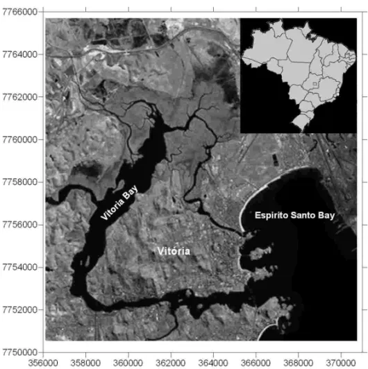
Herein, radiocarbon dates obtained from estuarine infilled deposits at Vitoria Bay (Fig. 1), Espirito Santo State, SE Brazil, are presented in association with high-resolution seismic data and micropaleontological un-published data from a MSc dissertation (F.K. Almeida, unpublished data). The main purpose of the present study is to present new radiocarbon dates obtained from an estuarine infilling sequence and their meaning in terms of changes in estuarine sedimentary processes during the Holocene. An attempt is made to fit dated and recognised seismic bounding surfaces within mid-to late-Holocene relative sea-level curves for the eastern Brazilian coast.
RELATIVE SEA-LEVEL CURVES: EASTERN BRAZILIAN COAST
Relative sea-level fluctuation curves for the eastern Brazilian coast have been investigated for more than 30 years, and the main results and discussions are pre-sented, for example, by Delibrias and Laborel (1969), Suguio et al. (1985), Martin et al. (1993, 1998, 2003), Angulo and Lessa (1997), Lessa and Angulo (1998), Martin (2003) and Angulo et al. (2006).
Generally, all these studies are based on radio-carbon dates in different materials, which point out the occurrence of a mid-Holocene sea-level highstand at about 5,100 years BP, followed by a fall to the cur-rent mean sea-level. The main disagreement is related to the time when relative sea-level crossed above the current mean sea-level, time and elevation of the maxi-mum transgression and the nature of late-Holocene sea-level fall (Angulo et al. 2006). Studies undertaken by Martin, Suguio and others (for example, Suguio et al. 1985, Martin et al. 1993, Martin 2003) have proposed that eastern Brazilian coast has undergone a
submer-gence phase during the last 7,000 years, with a maximum highstand at about 5,100 years BP (5,600 cal years BP), reaching up to 5m above the current mean sea-level (elevations can range locally from 2 to 5m). During the last 5,000 years, relative-sea level has dropped, but two periods of high-frequency oscillations occurred be-tween 4,300-3,500 cal yr BP and 2,700-2,100 cal yr BP. These are calibrated calendar years for Salvador curve (Martin 2003), but these oscillations were observed, ac-cording to the authors, along others sectors of the east-ern Brazilian coast.
A major discussion about time of sea-level high-stand and nature of falling relative sea-level began with Angulo and Lessa (1997) and was followed by Martin et al. (1998), Lessa and Angulo (1998), Martin (2003) and Angulo et al. (2006). Reviewing relative sea-level curves for Parana and Cananeia regions, Angulo and Lessa (1997) concluded that there was no indication of the two high-frequency oscillations, and that rates of sea-level fall were lower than earlier suggested (Suguio et al. 1985, Martin et al. 1993). A critical review of all the radiocarbon dated samples to established relative sea-level curves to the eastern Brazilian coast was un-dertaken by Angulo et al. (2006). The authors found that about 70% of the dated samples were misinterpreted or rather inaccurate indicators of sea-level. Using only ra-diocarbon dates from what was considered as accurate sea-level indicators (about only 30% of all the available dates), the authors present a sea-level envelop trend for the last 7,000 years. The results show a rather smooth drop in sea-level after the maximum transgression, be-tween 4,900 yrs BP –5,100 cal yrs BP and 5,400 yrs BP –5,700 cal yrs BP (Angulo et al. 2006), and no evidence of high-frequency oscillations. Milne et al. (2005) have applied a realistic model of glaciation-induced sea-level change to the Caribbean and South America. The authors have compared radiocarbon dates obtained for Pernam-buco, Rio de Janeiro and Santa Catarina coastline with model predictions. Data from Rio de Janeiro and Santa Catarina showed a good agreement with model predic-tions. Mean sea-level crossing time was predicted to have taken place at around 8,000 cal years BP, with a maximum transgression reaching up to 4.5m at around 7,200 cal years BP (for Rio de Janeiro).
inves-Fig. 1 – Location of the study area (Landsat image source: Embrapa).
tigation was carried out, no sea-level curve has been pro-posed so far. A few radiocarbon dates were obtained along the coast, especially at the Doce River coastal plain. Martin et al. (1996, 1997) have presented radio-carbon dates along the southern coast of Espirito Santo, closer to Vitoria Bay. Dates are presented as radiocar-bon ages, with no calibration to calendar years. Plotting the available dates reveals a maximum transgression up to 3.5 m above mean sea-level, which occurred around 5,410 years BC (Fig. 2). This is fairly in agreement with sea-level curves proposed for eastern Brazilian coast (Martin et al. 1993, Angulo and Lessa 1997).
STUDY AREA
Vitoria Bay is located along the southeastern Brazilian coast and harbours one of the most important national ports, Porto de Vitoria (Fig. 1). It is about 20km long and less than 0.5km wide. The estuary has a microti-dal regime, with-semi diurnal tides. Peak timicroti-dal currents can reach 0.5m/s, and the estuary is ebb flow dominated (Rigo 2004). The main navigation channel is constantly
dredged, and the lower reaches of the bay presents a significant anthropogenic influence. The upper reaches are bordered by tidal flats with relatively preserved man-grove forests and no dredging activities. Morphologi-cally, the upper reaches are characterised by a narrow submerged tidal channel, up to 8m deep with shallow margins, less than 0.5m deep during low water. Sedi-ment distribution is of predominantly sandy mud with widespread shell fragments. Fluvial sands are very re-stricted to Santa Maria da Vitoria river mouth and along narrower margins.
METHODS
764 ALEX C. BASTOS, CLAUDIA G. VILELA, VALÉRIA S. QUARESMA and FABIANA K. ALMEIDA
Fig. 2 – Radiocarbon dates obtained from Martin et al. (1996, 1997) for the coast between Serra (ES) and Guarapari (ES), south coast of Espirito Santo State.
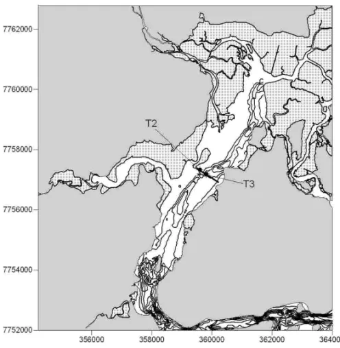
bay. Herein, only two cores and one seismic section with cores locations are presented. It is important to emphasise that these cores were located where thicker stratigraphic record was available. Therefore, accord-ing to the seismic records, one core (1.66m long BV-T2) was obtained from the margin of the tidal channel, and the second one (2.30m long BV-T3) was collected from the bottom of the channel (Fig. 3).
These cores were opened, photographed, macro-scopically described and sub-sampled for the following analysis: sediment grain size and mineral composition (M.M. Passos, unpublished data), benthic foraminifera (F.K. Almeida, unpublished data) and radiocarbon dat-ing.
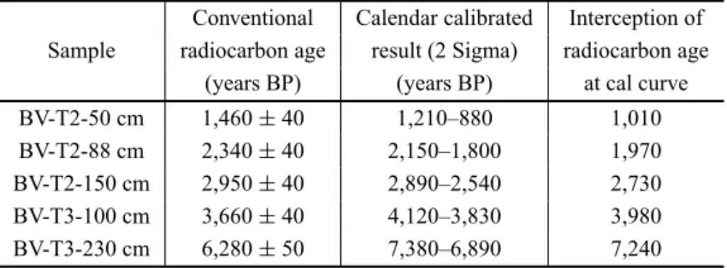
Shell samples and organic sediments from BV-T2 (50, 88 and 150 cm from the top) and BV-T3 (100 and 230cm from the top) were collected and sent to Beta An-alytics Radiocarbon Laboratory (Florida, USA). Radio-carbon measurements were taken with the AMS method, and dates are reported as radiocarbon years before pres-ent (prespres-ent = AD 1950). Calendar calibrated results are calculated from the Conventional Radiocarbon Age (Talma and Vogel 1993, INTCAL04 2004) using two sigma calibration (Variables used: C13/C12 = –3.1;1R = –8±69; Glob. Res = –200 to 500).
RESULTS
A representative seismic section reveals the presence of a main tidal channel, about 7m deep, with a thin ve-neer (15 cm thick) of modern sedimentation,
charac-terised by fluid muds (Fig. 4a). A basal reflector is ob-served at about 5m below the bed, which represents the acoustic basement, and probably the bedrock (Fig. 4b). A first-order reflector is defined here as an unconfor-mity and/or a seismic facies boundary. Three main seis-mic facies boundaries were observed (SB1, SB2, SB3). Second-order reflectors were recognised and describe the large-scale internal structure of the deposits.
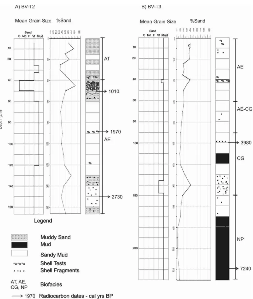
SB1 is characterised by a strong, continuous and very irregular/erosive reflector, which marks the top of the lower seismic unit (Fig. 4b). This seismic unit is characterised by a reflection free signature with a few ir-regular second-order reflectors. Sediment samples from Core BV-T3, which was collected at the bottom of the channel, show an 80cm thick greenish mud facies with sparse shell fragments at the base of the core (>85% mud). The top of this greenish mud facies is marked by a sandy/shell hash layer at 140cm interval, which de-fines SB1 (Fig. 5). The base of the core was dated for 7,240 cal. yrs BP, and is represented by a continuous sub-parallel second-order reflector (Table I).
Fig. 3 – Core locations in relation to the present bottom morphology.
766 ALEX C. BASTOS, CLAUDIA G. VILELA, VALÉRIA S. QUARESMA and FABIANA K. ALMEIDA
TABLE I Radiocarbon dating results.
Conventional Calendar calibrated Interception of Sample radiocarbon age result (2 Sigma) radiocarbon age
(years BP) (years BP) at cal curve
BV-T2-50 cm 1,460±40 1,210–880 1,010
BV-T2-88 cm 2,340±40 2,150–1,800 1,970
BV-T2-150 cm 2,950±40 2,890–2,540 2,730 BV-T3-100 cm 3,660±40 4,120–3,830 3,980 BV-T3-230 cm 6,280±50 7,380–6,890 7,240
The upper most seismic unit is characterised by parallel to sub-parallel reflectors that are truncated by an irregular reflector representing the major modern un-conformity – SB3 (channel topography associated with modern sedimentation). These seismic reflectors are rep-resented by BV-T2 core sediments (e.g. Fig. 5). The core is characterised by an intercalation of sandy mud and muddy sand layers with a 10cm thick main shell hash layer at 50cm, which gives a calendar age of 1,010 cal yrs BP. This intercalation is observed down to 70cm, where the core becomes dominantly muddy with shell fragments well distributed down to the base of the core. Two more time horizons were obtained along this core: 1,970 cal. yrs BP at 88cm and 2,730 cal. yrs BP at 150cm (e.g. Fig. 4, Table I).
F.K. Almeida (unpublished data) has carried out a paleoenvironmental analysis based on benthic fora-minifera assemblage sampled from BV-T2 and BV-T3. Results are graphically presented in Figure 5. Based in statistical analyses including similarity and cluster anal-yses, the author has recognised four biofacies: NP (dom-inant species: Nonion depressulus and Pseudononion atlanticum), CG (Cribroelphidium gunteri,C. vadescens andGlobocassidulina subglobosa), AE (Ammonia par-kinsoniana,A. tepidaandElphidiumspp.) and AT (Am-motium morenoiand textularids). NP and CG were only observed along BV-T3, from 150 to 230cm and from 90 to 150cm, respectively. These biofacies are typical of in-ner shelf open sea environment. A transition zone from CG to AE biofacies were recognised between 60cm to 90cm in T3. Biofacies AE was predominant at BV-T3 from 10 to 60cm, and at BV-T2 it was observed from 40 to 160cm. This biofacies refers to a brackish envi-ronment. Biofacies AT is typical of agglutinated tests
and was observed at the top of BV-T2, which represents mangrove-tidal flat environments.
DISCUSSION
An integrated analysis of high-resolution seismic data, core sediment texture and foraminiferal biofacies with radiocarbon dates allowed a preliminary interpretation of the late-Holocene infilling processes in Vitoria Bay estu-ary. Considering a stratigraphic sequence framework, the available dataset did not present any record or evidence of lowstand fluvial deposits. The interpreted acoustic basement represents the bedrock and there is no seismic evidence, within the section shown herein, of fluvial de-posits resting on top of the bedrock. Moreover, the cores did not reach the bedrock basement, so there is no record of the entire sedimentary sequence above the bedrock.
768 ALEX C. BASTOS, CLAUDIA G. VILELA, VALÉRIA S. QUARESMA and FABIANA K. ALMEIDA
(CG biofacies). The top of this unit was dated for 3,980 cal. yrs BP, which would fit in the regressive phase, in a general relative sea-level curve for the eastern Brazilian coast. However, considering all the discussion regard-ing the time and duration of the Holocene highstand, it is possible that highstand conditions have lasted un-til around 4,000 yrs BP, or sediment input was too low to start a regressive phase. By analysing the sea-level envelop proposed by Angulo et al. (2006), it is clear that sea-level has dropped very gently after the high-stand. Assuming this interpretation, this unit represents a transgressive-highstand facies.
Bounding surface SB2 represents a basal regressive surface (RS), which separates transgressive/highstand and regressive estuarine facies. The regressive seismic unit shows reflectors downlapping RS along the west-ern end of the section and parallel to sub-parallel reflec-tors along the eastern end, which are truncated by SB3 (modern unconformity). The regressive mud/sand fa-cies is associated with a clear increase in sand content, which was observed at 70 to 60cm of BV-T3 and contin-uously along BV-T2 (∼40-50%). A significant change in benthic foraminifera assemblage was observed along BV-T3. Biofacies AE dominates in the top 60 cm of BV-T3, and is associated with a brackish environment, which documents a decrease in salinity and in open sea circulation. Biofacies AE is dominant along BV-T2 from 166 to 40 cm, which dates for around 1000 yrs BP. The top of this regressive facies is characterised by a change in benthic foraminifera assemblage (AT bio-facies). Agglutinated foraminifera become dominant, which indicate the establishment of mangroves.
The modern channel morphology is described as a major unconformity (SB3) that truncates regressive es-tuarine beddings, at least 1,000 cal yrs old. It may repre-sent a regressive ravinement surface due to tidal scouring along the main channel, or a tidal diastem, as defined by Lessa et al. (1998) for Paranagua Bay. Considering a gentle drop in relative sea-level during the last 4,000 yrs (Angulo et al. 2006), it is also possible that this surface has changed its position due to tidal channel meander.
Hitherto, the results obtained for this estuarine sys-tem indicate that, until around 4,000 cal. yrs BP, environ-mental conditions were still of an open bay, with a free and wide connection with marine waters. This may
rep-resent highstand conditions with low rates of sediment supply. Evidences of a regressive phase are supported by reflectors downlapping onto a regressive surface and the establishment of typical brackish water and mangrove foraminifera assemblages.
CONCLUSIONS
Original radiocarbon ages ranging from 1,010 cal. yrs BP to 7,240 cal. yrs BP were obtained from two sedimen-tary cores in Vitoria Bay, representing a 5m thick strati-graphic sequence. Seismic interpretation has allowed the recognition of different seismic facies and estratigraphic surfaces.
The results indicate that, until around 4,000 cal. yrs BP, environmental conditions in Vitoria Bay were still of an open bay, with a free and wide connection with marine waters. These phases are characterised by trangressive mud facies separated from trangressive/highstand mud-sand facies by a tidal ravinement surface. Regressive facies rest on the top of a regressive surface younger than 4,000 yrs BP, and are characterised by an increase in sand content and the establishment of typical brack-ish water and mangrove foraminifera assemblages. Ra-diocarbon dates within the regressive facies show ages ranging from 2,700 to 1,010 cal. yrs BP. The present channel morphology represents a tidal scouring surface or a tidal diastem, which erodes and truncates regressive facies bedding and, locally, may also expose trangres-sive facies.
It is important to note that the results and conclu-sions here presented correspond to a first interpretation of mid- to late-Holocene processes in Vitoria Bay. A complete analysis of seismic data acquired for the en-tire bay, together with more core analysis, will provide a better understanding of the infilling processes during the Holocene.
ACKNOWLEDGMENTS
Geologia Marinha, Universidade Federal Fluminense, for providing the sub-bottom profiler. Special thanks are also to the revisers of the manuscript.
RESUMO
A Baía de Vitória é um estuário com 20 km de comprimento, morfologicamente estreito, com um regime de micromaré e, como outros estuários modernos, formado durante a última transgressão pós-glacial. A morfologia de fundo do estrato estuarino é caracterizada por um canal natural principal li-mitado por planícies de maré com manguezais desenvolvi-dos. Datações de radiocarbono originais foram obtidas para a área. Cinco idades de radiocarbono estendendo-se de 1.010 a 7.240 anos AP foram obtidas através de dois testemunhos de sedimento, representando uma sequência estratigráfica de 5 m de espessura. Os resultados indicam que até aproximada-mente 4.000 anos cal. AP, as condições ambientais da Baía de Vitória eram ainda de uma baía aberta, com uma conexão livre e aberta com águas marinhas. Durante os últimos 4.000 anos a baía experimentou uma fase de regressão importante, tornando-se mais restrita em termos de circulação da água do mar e provavelmente aumentando a energia de marés. Três superfícies estratigráficas principais foram reconhecidas, li-mitando fácies transgressiva, transgressiva/nível de mar alto e regressiva. A morfologia do canal atual representa um dias-tema de maré, mostrando fácies regressivas truncadas e erodi-das. Biofácies de foraminíferos, passando de ambiente mari-nho para ambiente salobro e de manguezais em planície de maré confirmam a interpretação sismoestratigráfica. A ausência de biofácies de mangue em um dos dois testemunhos é também uma indicação de ravinamento de maré atual.
Palavras-chave: sísmica de alta-resolução, evolução estuari-na holocênica, datação por radiocarbono, Baía de Vitória, bio-fácies.
REFERENCES
ALLENGPANDPOSAMENTIERHW. 1993. Sequence
stra-tigraphy and facies model of anincised valley fill: the Gi-ronde estuary, France. J Sediment Petrol 63: 378–392. ANGULORJANDLESSAG. 1997. The Brazilian sea level
curves: a critical review with emphasis on the curves from Paranagua and Cananeia regions. Mar Geol 140: 141– 166.
ANGULORJ, LESSAGCANDSOUZAMC. 2006. A
criti-cal review of mid- to late-Holocene sea-level fluctuations
on the eastern Brazilian coastline. Quatern Sci Revs 25: 486–506.
DALRYMPLERW, ZATTLINBAANDBOYDR. 1992. Es-tuarine facies models: conceptual basis and stratigraphic implications. J Sediment Petrol 62: 1130–1146. DELIBRIASCANDLABORELJ. 1969. Recent variations of
the sea level along the Brazilian coast. Quaternaria 14: 45–49.
INTCAL04. 2004. Radiocarbon age calibration. Calibration Issue of Radiocarbon 46(3).
LESSAGC. 2005. Baías Brasileiras: grandes estuários em
uma costa regressiva? Simp Baías, 10◦Cong. ABEQUA, Guarapari-ES, Anais, CD-ROM.
LESSAGCANDANGULORJ. 1998. Oscillations or not oscil-lations, that is the question-reply. Mar Geol 150: 189–196. LESSAGCANDMASSELINKG. 1995. Sedimentation and
hydrodynamic changes in a backbarrier macrotidal estu-ary: a morphodynamic approach. Mar Geol 129: 25–46. LESSA GC, MEYERSSANDMARONE E. 1998. Holocene
stratigraphy in the Paranagua Bay estuary, south Brazil. J Sediment Res 68(6): 1060–1076.
LOBOFJ, DIASJMA, GONZALEZR, HERNANDEZ-MOLI
-NAFJ, MORALESJAANDDIAZ DELRIOV. 2003. High
Resolution Seismic Stratigraphy of a narrow, bedrock-controlled estuary: The Guadiana Estuarine System, SW Ibéria. J Sediment Res 73: 973–986.
MARTIN L. 2003. Holocene Sea-Level History Along Eastern-Southeastern Brazil. Anuário IGEO, UFRJ, 26 WorkshopBaía: 13–24.
MARTINL, SUGUIOKANDFLEXORJ-M. 1993. As
flutua-ções do nível do mar durante o Quaternário superior e a evolução geológica de “deltas” brasileiros. Bol IG/USP 15: 186.
MARTIN L, SUGUIO K, FLEXOR JM, DOMINGUEZ JML
ANDBITTENCOURTACSP. 1996. Quaternary sea-level
history and variation in dynamics along the central Brazil Coast: consequences on coastal plain construction. An Acad Bras Cienc 68: 303–354.
MARTINL, SUGUIO K, DOMINGUEZJML ANDFLEXOR
JM. 1997. Geologia do Quaternário costeiro do litoral norte do Rio de Janeiro e do Espírito Santo. CPRM Serv Geol Brasil, 112 p.
770 ALEX C. BASTOS, CLAUDIA G. VILELA, VALÉRIA S. QUARESMA and FABIANA K. ALMEIDA
Cananeia regions” [Mar Geol 140: 141–166]. Mar Geol 150: 179–187.
MARTINL, DOMINGUEZJMLANDBITTENCOURTACSP. 2003. Fluctuating Holocene sea levels is eastern and southeastern Brazil: evidence from a multiple fossil and geometric indicators. J Coast Res 19: 101–124.
MILNE GA, LONGAJANDBASSETTE. 2005. Modeling
Holocene relativesea-level observations from the Carib-bean and South America. Quatern Sci Revs 24: 1183– 1202.
NICHOLSL, BOYDRANDPENLANDS. 1994. Stratigraphic
response of wave dominated estuaries to different relative sea-level and sediment supply histories: Quaternary case studies from Nova Scotia, Louisiana and eastern Australia. In: DALRYMPLERANDBOYDR (Eds), Incised-Valley Systems: Origin and Sedimentary Sequences, SEPM Sp Publ 51: 265–283.
RIGO D. 2004. Análise do escoamento em regiões estuar-inas com manguezais – medições e modelagem na Baía de Vitória, ES. Tese de Doutorado, Programa de Pós-Graduação em Engenharia Oceânica, COPPE, UFRJ, 200 p.
SOUZAFILHOW M, COHENMCL, LARARJ, LESSAGC, KOCHBANDBEHLINGH. 2006. Holocene coastal
evo-lution and facies model of the Bragança macrotidal flat on the Amazon Mangrove Coast, Northern Brazil. J Coast Res, Sp Issue 39: 306–310.
SUGUIOK, MARTINL, BITTENCOURTACSP, DOMINGUEZ
JML, FLEXORJMANDAZEVEDOAEG. 1985. Flutua-ções do nível relativo do mar durante o Quaternário Su-perior ao longo do litoral brasileiro e suas implicações na sedimentação costeira. Rev Bras Geoc 15: 273–286. TALMAASANDVOGELJC. 1993. A Simplified Approach