www.nat-hazards-earth-syst-sci.net/12/3255/2012/ doi:10.5194/nhess-12-3255-2012
© Author(s) 2012. CC Attribution 3.0 License.
and Earth
System Sciences
Acoustic and seismic imaging of the Adra Fault (NE Alboran Sea):
in search of the source of the 1910 Adra earthquake
E. Gr`acia1,2, R. Bartolome1,2, C. Lo Iacono1,2, X. Moreno1,3, D. Stich4, J. J. Mart´ınez-Diaz5, G. Bozzano6,
S. Mart´ınez-Loriente1,2, H. Perea1,2, S. Diez1, E. Masana3, J. J. Da ˜nobeitia1,2, O. Tello7, J. L. Sanz7, E. Carre ˜no8, and EVENT-SHELF Team*
1Unitat de Tecnologia Marina – CSIC, CMIMA, Pg. Mar´ıtim de la Barceloneta 37–49, 08003 Barcelona, Spain 2Institut de Ci`encies del Mar – CSIC, CMIMA, Pg. Mar´ıtim de la Barceloneta 37–49, 08003 Barcelona, Spain 3RISKNAT, Dpt. Geodin`amica i Geof´ısica, Universitat de Barcelona, Mart´ı i Franqu`es s/n, 08028 Barcelona, Spain 4Instituto Andaluz de Geof´ısica (IAG), Univ. Granada, 18071 Granada, Spain
5Instituto de Geociencias UCM, CSIC, Dpto. Geodin´amica, Facultad de Ciencias Geol´ogicas, Universidad Complutense, 28004 Madrid, Spain
6Servicio de Hidrograf´ıa Naval, Av. Montes de Oca 2124, C1270ABV Buenos Aires, Argentina 7Instituto Espa˜nol de Oceanograf´ıa, Coraz´on de Mar´ıa 8, 28002 Madrid, Spain
8Red S´ısmica Nacional, Instituto Geogr´afico Nacional, c/ General Ib´a˜nez Ibero, 3, 28003 Madrid, Spain *M. Farran (ICM-CSIC), E. Andara (IGME), S. P´erez and M. J. Rom´an Alpiste (UG)
Correspondence to:E. Gr`acia ([email protected])
Received: 21 March 2012 – Revised: 19 July 2012 – Accepted: 9 August 2012 – Published: 7 November 2012
Abstract. Recently acquired swath-bathymetry data and high-resolution seismic reflection profiles offshore Adra (Almer´ıa, Spain) reveal the surficial expression of a NW– SE trending 20 km-long fault, which we termed the Adra Fault. Seismic imaging across the structure depicts a sub-vertical fault reaching the seafloor surface and slightly dip-ping to the NE showing an along-axis structural variability. Our new data suggest normal displacement of the uppermost units with probably a lateral component. Radiocarbon dating of a gravity core located in the area indicates that seafloor sediments are of Holocene age, suggesting present-day tec-tonic activity. The NE Alboran Sea area is characterized by significant low-magnitude earthquakes and by historical records of moderate magnitude, such as theMw=6.1 1910 Adra Earthquake. The location, dimension and kinematics of the Adra Fault agree with the fault solution and magnitude of the 1910 Adra Earthquake, whose moment tensor analysis indicates normal-dextral motion. The fault seismic parame-ters indicate that the Adra Fault is a potential source of large magnitude (Mw≤6.5) earthquakes, which represents an un-reported seismic hazard for the neighbouring coastal areas.
1 Introduction
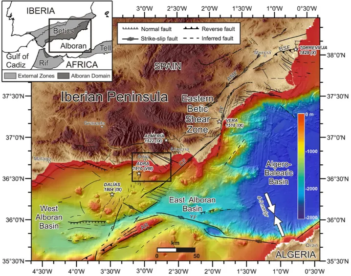
Fig. 1.Regional topographic and bathymetric map of the southeast Iberian margin constructed from digital grids released by SRTM-3, IEO bathymetry (Ballesteros et al., 2008; Mu˜noz et al., 2008) and MEDIMAP multibeam compilation (MediMap et al., 2008) at∼90 m grid-size. Epicenters of the largest historical earthquakes (MSK Intensity>VIII) in the region are depicted by a white star (I.G.N., 2010). Grey arrows pointing opposite each other show the direction of convergence between the Eurasian and African plates from NUVEL1 model (DeMets et al., 2010). The black outlined rectangle depicts the study area presented in Fig. 2. BSF: Bajo Segura Fault; AMF: Alhama de Murcia Fault, PF: Palomares Fault, CF: Carboneras Fault, YF: Yusuf Fault, AR: Alboran Ridge. Inset: Plate tectonic setting and main geodynamic domains of the south Iberian margin along the boundary between the Eurasian and African Plates.
The present-day crustal deformation of the southeastern Iberian margin, which includes the Iberian Peninsula and adjacent offshore Mediterranean region, is driven mainly by the NW–SE convergence (4.5–5.6 mm yr−1) between the African and Eurasian plates (e.g. Argus et al., 1989; DeMets et al., 2010) (Fig. 1). This convergence is accommodated over a wide deformation zone with significant seismicity south of the Iberian Peninsula (e.g. Buforn et al., 2004; Stich et al., 2003a, 2006, 2010). Quaternary faulting activity is dominated by a large left-lateral strike-slip system referred to as the Eastern Betic Shear Zone (EBSZ) (e.g. Bousquet, 1979; Sanz de Galdeano, 1990; Silva et al., 1993). This ac-tive fault system runs along more than 450 km, and its ter-minal splays (i.e. the Bajo Segura Fault to the northeast
and the Carboneras Fault to the southwest) extend into the sea (Comas et al., 1999; Alfaro et al., 2002; Gr`acia et al., 2006; Moreno et al., 2008; Moreno, 2011; Perea et al., 2012) (Fig. 1). In the SE Iberian margin, instrumental seismic-ity is characterized by continuous, shallow seismic events of low to moderate magnitude (Mw<5.5) (Buforn et al., 1995, 2004; Stich et al., 2003a, 2006, 2010). Nevertheless, large destructive earthquakes (MSK Intensity IX–X) have oc-curred in the region, as revealed by historical records (I.G.N., 2010) (Fig. 1). They may represent a significant earthquake and tsunami hazard along the Iberian Peninsula and North African coasts.
the northern Alboran Sea (Fig. 1). This area demonstrated recent seismic activity with most of the epicentres located offshore, especially during the 1993–1994 earthquake series (up toMw=4.9) (Stich et al., 2001). In addition, this area includes the submarine epicentral zone of the Adra histori-cal earthquake in 1910 with an estimated Mw=6.1 (Stich et al., 2003b) (Fig. 1). The neotectonics of the structures lo-cated onshore (e.g. Campo de Dal´ıas in the Almer´ıa province, SE Spain) has been studied in detail (e.g. Mart´ınez-D´ıaz and Hern´andez-Enrile, 2004; Mar´ın-Lechado et al., 2005, 2007; Pedrera et al., 2012) (Fig. 2). However, little is known about the structures located offshore. To investigate the ac-tive tectonic sources in the Almer´ıa margin offshore Adra (Spain) we carried out the EVENT-SHELF high-resolution seismic survey (Figs. 1, 2, 3). The main objectives of this study are (a) to describe the seafloor morphology of the area, (b) to characterize the shallow structure and kinematics of the largest fault newly recognized, the Adra Fault, and (c) to find out whether the Adra Fault is the tectonic source of the historically recorded 1910 Earthquake.
2 Tectonics and seismicity of the Adra–Almer´ıa margin
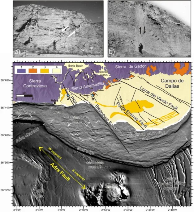
The study area is located in the Adra–Almer´ıa margin, cor-responding to the Betic internal zones or Alboran Domain (Figs. 1 and 2). Onshore, this area includes the Contraviesa and G´ador Ranges constituted by the Alpujarride metamor-phic complex, basement of the Neogene to Quaternary sedi-ments of the Campo de Dal´ıas, where recent deformation has been recognized (e.g. Mart´ınez-D´ıaz and Hern´andez-Enrile, 2004; Mar´ın-Lechado et al., 2005; Pedrera et al., 2012) (Fig. 2). The largest faults in the Campo de Dal´ıas are the Loma del Viento, Balanegra and Punta Entinas faults, the last two controlling several km-long linear segments of the coast-line. They are NW–SE striking normal faults forming half-graben structures, such as the Puente del Rio Fault (Mart´ınez-D´ıaz and Hern´andez-Enrile, 2004) (Fig. 2a), although the Loma del Viento fault has a certain dextral component af-fecting the Quaternary deposits (Pedrera et al., 2012). In the Campo de Dal´ıas, near the Loma del Viento Fault, Pleis-tocene raised marine terraces are present, forming a stair-case of 16 terraces that reaches 82 m a.s.l. (Zazo et al., 2003). These terraces provide information about recent uplift of the region with maximum values of 0.046 m ka−1 over the last 130 ka for the up-thrown block of the Loma del Viento (Zazo et al., 2003; Mar´ın-Lechado et al., 2005) (Fig. 2). On the ba-sis of pre-existing offshore commercial multichannel seismic reflection profiles from the Almer´ıa shelf, several authors suggest the presence of NW–SE trending faults and open, gentle folds extending up to 100 km in length in the off-shore area (Rodr´ıguez-Fern´andez and Mart´ın-Penela, 1993; Mart´ınez-D´ıaz and Hern´andez-Enrile, 2004; Mar´ın-Lechado et al., 2005, 2007; Pedrera et al., 2012).
In regards to instrumental seismicity, the most intense seismic period recently recorded in this area occurred dur-ing 1993–1995, where several multiplets of up to magnitude
Mw=4.9 occurred near Adra (Stich et al., 2001) and pro-duced significant damage in the Berja and Adra areas. Since then, the seismic crisis of July/August 1997 (Mw≤4.5, Stich et al., 2003a), October/November 2008 (Mw≤4.4, Stich et al., 2010) and more recently November 2010 (Mw≤4.2) demonstrates the continuous seismicity nucleated around Campo de Dal´ıas, which is of shallow depth (Pedrera et al., 2012). However, historical and archaeological records suggest that the Adra–Almer´ıa region has been affected by at least 50 destructive earthquakes (MSK Intensity>VIII) over the past 2000 yr (e.g. Mar´ın-Lechado et al., 2005), pro-viding evidence of a significant seismic hazard. The town of Almer´ıa was devastated by earthquakes in 1487, 1522 (I0=IX MSK) and 1658 (I0=VIII MSK). In 1804, a long period of seismic activity (up to I0=IX MSK) affected Adra and nearby areas (e.g. Mar´ın-Lechado et al., 2005). These events have been mainly attributed to the motion along the Carboneras fault system (Keller et al., 1995). On the other hand, it has been suggested that the 1910 Adra Earthquake (Mw=6.1, I0=VIII MSK in Adra) was probably generated by N120–N130 trending faults offshore (Stich et al., 2003b), although, the tectonic source of this earthquake is still un-known. Searching for the source of this earthquake is the aim of the present study.
3 Data and methods
Fault exploration of active regions offshore integrates the most advanced technologies covering different scales of res-olution (e.g. Bartolome et al., 2009). Acoustic mapping tech-niques, such as swath-bathymetry, allow us to identify the geomorphological evidence of active faults, such as seafloor ruptures, fault scarps and fault traces. Seismic imaging meth-ods, especially high-resolution, enable us to detect the strati-graphic evidence of past seismic activity, such as upward decreasingly displaced seismic horizons, folded and faulted reflectors, zones of shearing and discontinuities. Sediment sampling methods and subsequent analyses allow us to char-acterize and date mass transport deposits triggered during seismic events, and to shed light on the nature and age of the most recent sediments.
Fig. 2.Shaded relief bathymetric map of the Adra–Almer´ıa margin. The Adra Fault and segments are marked in yellow. Onshore, main structures and geological units are also depicted. They correspond to 1: Alboran Domain basement; 2: Upper Miocene deposits; 3: Pliocene deposits; and 4: Quaternary deposits (modified from Mart´ınez-D´ıaz, 1998; Sanz et al., 2004; Mar´ın Lechado et al., 2005; Fern´andez-Salas et al., 2009; Pedrera et al., 2012). PRF: Puente del R´ıo Fault; CF: Carboneras Fault. Blue stars depict location of pictures from insets. Insets: Field examples of normal faults from the Adra-Campo de Dal´ıas region.(a)The N155 Puente del R´ıo normal fault separating the deltaic Pliocene deposits from the grey Paleozoic phyllites on the footwall.(b)A N170 trending normal fault cutting a Pleistocene alluvial fan on the southern slope of Sierra Alhamedilla. The striae show pitch of 110◦and dextral component (modified from Mart´ınez-D´ıaz, 1998).
the Simrad EM12S data acquired during the IMPULS cruise, and 180 kHz Elac Nautik SeaBeam 1050D data acquired during the EVENT-SHELF cruise (Fig. 2). Digital terrain models at 70 m and 20 m grid size were obtained using HIPS-CARIS and Caraibes-TD softwares (IFREMER, France) and slope maps were generated with ArcGIS (Figs. 2 and 3).
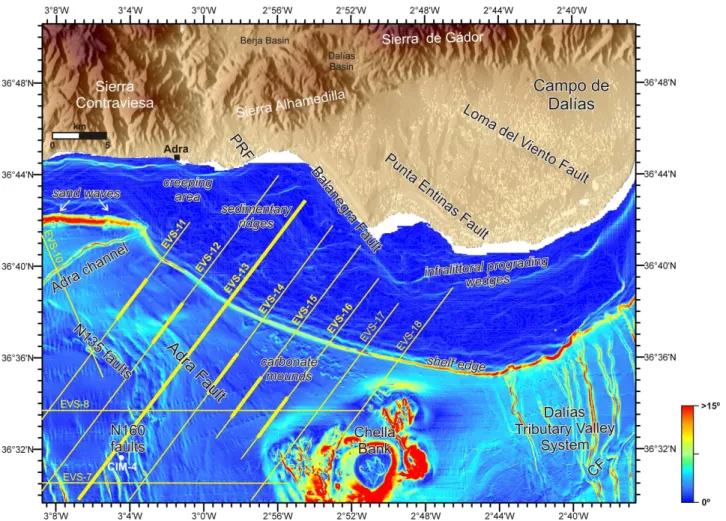
Fig. 3.Slope map of the Adra–Almer´ıa shelf and upper slope with the location of the main features (illumination from the NE, scale in degrees). Sparker profiles acquired during the EVENT-SHELF cruise across the Adra Fault are depicted by yellow lines. Thicker yellow lines correspond to profiles presented in Figs. 4 and 6. White dot locates core CIM-4 presented in Fig. 5. PRF: Puente del R´ıo Fault; CF: Carboneras Fault.
4 kJ source was used for depths below 150 m, whereas the 6 kJ was adopted for the deeper areas. The receiver consisted of a 9 m long, 24-hydrophone single-channel streamer. The sampling rate was 100 µs with a record length of 1.5–2.0 s TWTT (two-way travel time). Processing was carried out using the software Geotrace. The processing flow included change in data polarity, debiasing, a minimum bandpass fil-ter (350–1500 Hz), AGC (10 ms window), gain (1–3 dB) and spherical divergence, and swell filter. Data were exported to SEG-Y format and integrated in the SMT Kingdom Suite software. A total of 11 Sparker profiles (referred to as EVS-7, EVS-8 and EVS-10 to EVS-18) were acquired in the study area (Fig. 3). Most of the profiles, which ran from the shelf to the mid-slope, were oriented NE–SW, perpendicular to the main fault orientation on land. Best results were achieved in flat areas with highly penetrative sediments, while abrupt slope areas and volcanic outcrops displayed very low pene-tration (Fig. 4). Seismic visualisation and interpretation were carried out using the SMT Kingdom Suite software.
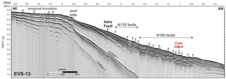
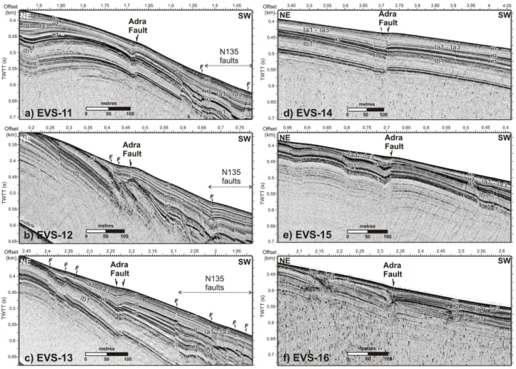
Fig. 4.Regional Sparker profile EVS-13 from the shelf to the middle slope. The Adra Fault and its parallel N135 faults together with the neighbouring N160 faults are imaged. Sediment core CIM-4 is located. Age of horizons are H1: Late Quaternary, H2: Early Quaternary (1.8 Ma), and H3: Late Pliocene (3.6 Ma). Vertical exaggeration at the seafloor∼1.5.
14C AMS dating), we hand-picked 6 samples containing 7 and 10 mg of mixed or monospecific planktonic foraminifera with a diameter larger than 250 µm. Samples were processed and measured at the NOSAMS-WHOI laboratory. The14C ages of hemipelagic samples were calibrated using the Ma-rine09 curve (Reimer et al., 2009) included in Calib 6.1 soft-ware and considering a present-day reservoir age (1R) of −22±3514C yr for the M´alaga site (Table 1).
4 Results
4.1 Morphology of the Adra shelf and upper slope
The study area is located to the northeast of the Albo-ran Basin, extending from 2◦48′W to 3◦08′W, and from 36◦44′N to 36◦32′N (Figs. 2 and 3). The shelf drastically narrows from east to west (from 12 to 4 km) and has a gener-ally smooth morphology with a gradient less than 1◦(Figs. 3 and 4). On the widest part of the shelf, two NW–SE trend-ing slightly sigmoidal ridges are visible (Sanz et al., 2004) (Fig. 2), corresponding to sedimentary ridges (Fig. 4). Fol-lowing a NW–SE trend, the offshore continuation of the Balanegra Fault escarpment is clearly recognized (Figs. 2 and 3).
Holocene infralittoral prograding wedges are also identi-fied on the shelf (Figs. 2 and 3). They correspond to narrow (up to 2.5 km wide) morphosedimentary units which develop seaward from the shoreface and extend to a well-defined break of slope at water depths of 35–40 m (Fern´andez-Salas et al., 2007). The shelf edge locally depicts a maximum slope of 15◦. Incised on the shelf edge (100 m depth), the NE– SW trending 11.3 km long Adra Channel obliquely cuts the upper slope and stops around 650 m depth. At the base of the shelf edge, between 2◦56′W and 2◦52′W, a cluster of
small rounded monticules correspond to coral mounds, first described by Ballesteros et al. (2008) (Fig. 2).
The upper slope is dominated by a large, isolated flat-topped circular seamount with very steep slopes (>15◦) re-ferred to as the Chella Bank, bounded by irregular volcanic ridges (e.g. Lo Iacono et al., 2008) (Figs. 2 and 3). To the east of the bank, the deeply incised Dal´ıas Tributary Valley System drains from the shelf edge until it intersects the left-lateral Carboneras Fault, which produces a sharp deflection of its channels and gullies (Gr`acia et al., 2006; Moreno et al., 2008). To the west of the Chella Bank, numerous lin-ear structures correspond to the morphological expression of fault systems. Most of the faults exhibit steep scarps that affect the seafloor, indicating present-day activity (Figs. 2 and 3). On the swath-bathymetric and slope maps, we iden-tify a N132 trending 18.5 km long and ∼500 m wide lin-eation, which corresponds to the surface expression of a fault, which is termed the Adra Fault (Figs. 2, 3 and 4). Parallel to this fault, NW–SE trending narrowly-spaced, short (3–4 km long), rectilinear escarpments are termed the N135 faults. To the south of these structures, we observe a succession of NNW–SSE trending, closely spaced, en echelon short faults (1–3 km long) termed the N160 faults (Figs. 2 and 3).
4.2 Seismostratigraphy and age of the recentmost sediments
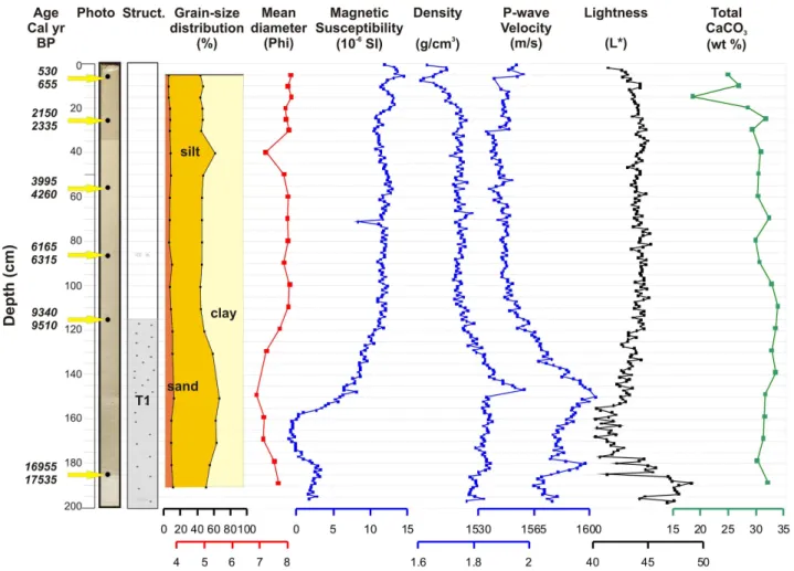
Fig. 5.Image, lithological description, grain-size distribution, mean diameter, magnetic susceptibility, density, P-wave velocity, lightness, total calcium carbonate and calibrated ages of CIM-4 sediment core. T1 refers to a mud-rich turbidite interval.
Table 1.Location of the studied core, radiocarbon AMS data and sample age calibrations based on the Marine09 curve (Reimer et al., 2009) included in Calib 6.1 calibration software.
Core # Lat Lon Water AMS Core Foraminifera Radiocarbon 1R* 1σ
depth lab depth sampled age calibrated age (◦N) (◦W) (m) reference (cm) (yr BP±1σ ) (Cal yr BP)
CIM-4 36◦31.55′ 3◦04.37′ 850 60 691 8.5–10 Globorotalia inflata 1000±30 −22±35 530–655
Adra–Almer´ıa Margin 60 692 28.5–30 Globorotalia inflata 2560±45 −22±35 2150–2335
60 693 58.5–60 Globorotalia inflata 4070±40 −22±35 3995–4260 60 694 88.5–90 Globorotalia inflata 5800±40 −22±35 6165–6315 60 695 117–118.5 Neogloboquadrina pachyderma 8730±45 −22±35 9340–9510 60 696 186–187.5 Globigerina bulloides 14 550±95 −22±35 16 955–17 535
* Local reservoir correction (1R) for the M´alaga site based on Stuiver and Reimer (1993).
sub-units and seismic horizons in the study area (Fig. 4). The Sparker profiles, with a maximum penetration of up to 400 ms TWTT display an alternation of sequences of (a) con-tinuous, high-amplitude parallel-bedded well-stratified seis-mic facies and (b) semi-transparent seisseis-mic facies with moderate-low amplitudes. We distinguished 4 seismostrati-graphic units, from top to bottom, units Ia1, Ia2, Ia3 and Ib1, separated by horizons H1 to H3, respectively (Fig. 4). Based
on the correlation with the horizons previously defined in the Almer´ıa margin (Moreno, 2011), the ages of the Adra seis-mic horizons are Late Quaternary for H1, Early Quaternary (base of Calabrian stage, 1.8 Ma) for H2, and Late Pliocene (3.6 Ma) for H3.
this profile, the uppermost sedimentary units Ia1–Ia3 can be followed upslope north of the Adra Fault, where it onlaps the lower unit Ib1 (Fig. 4). Sampled sediments consisted in olive to olive-grey silty clay (Holocene section) to clayey silt (early Holocene–Late Pleistocene section), with an aver-age mean diameter of 7.8 phi. Their composition is mainly terrigenous with an average calcium carbonate content of 30 % (Fig. 5). Physical properties (magnetic susceptibility, density, Pwave-velocity and lightness) show fairly constant values in the upper half of the core. By contrast, from 115 cm depth to the base of the core, density and Pwave-velocity values slightly increase, whereas magnetic suscepti-bility and lightness decrease. Texture, sedimentary structures and physical properties allow us to distinguish two main fa-cies: hemipelagite and turbidite (Fig. 5). From top to bottom, there is a 115 cm thick hemipelagic interval interrupted by a thin 10 cm silty layer at 40 cm depth below the seafloor. From 115 cm to the base of the core, an 85 cm thick dark interval (T1) characterized by thin irregular muddy layers and coarse silty lenses, corresponds to a mud-rich turbidite (Fig. 5). The age model of core CIM-4 is based on 5 ra-diometric dates, assuming that the sedimentation rate is con-stant between contiguous dated samples above the turbidite T1, the age of which is older than 9510 Cal yr BP. The sixth available date (16 955–17 535 Cal yr BP) corresponds to an older value, probably related to reworked material within tur-bidite T1. Earthquakes may constitute a likely trigger mech-anism of these gravity flow deposits in the NE Alboran Sea. However, without a synchronicity test based on widespread and coeval mass-transport deposits to demonstrate that these are simultaneously triggered by an earthquake, other pro-cesses cannot be ruled out (e.g. Gr`acia et al., 2010). Cali-brated dates reveal Holocene age with an average sedimen-tation rate of∼12.3 cm kyr−1(Fig. 5). The youngest age is 530–655 Cal yr BP at 5 cm depth with the result that we can assume that the age of the seafloor is present-day (Table 1). This is important for the correlation with the Sparker profiles where it is possible to ascertain whether faults rupture the seafloor (Figs. 4 and 6).
4.3 High-resolution seismic imaging of the Adra Fault
Analysis of the acoustic and seismic data distinguishes two main parallel segments along the Adra Fault: the western and eastern segments (Fig. 2). Between the segments, there is a 250 m wide left-stepping offset. The succession of six high-resolution Sparker profiles across the Adra Fault illustrates how its shallow structure varies along-strike (Figs. 4 and 6).
The western segment is 9.2 km long and trends N130. At its NW end, stratified unit Ib1 (Pliocene) is folded by a wide, open anticline (Fig. 6a, profile EVS-11). The Adra Fault is sub-vertical and cuts the high-amplitude anticline deforming units Ia3 and Ia2, although the fault does not seem to reach the seafloor. In the middle of the segment (Fig. 6b, profile EVS-12), an uplifted narrowly folded block of transparent
facies marks the location of the Adra Fault. This fault sep-arates zones of different stratigraphy belonging to unit Ib1, forming what we interpret as a pressure ridge. Onlapping this ridge is a wedge of stratified facies from the top of unit Ib1 and units Ia1 to Ia3. They are slightly folded and cut by tightly spaced sub-vertical faults reaching the surface. The geometry of the central part of this segment also co-incides with a 20–25 m high upwarp of the seafloor, as ob-served between offsets 0.4 and 0.55 km. The southern part of this segment (Figs. 4 and 6c profile EVS-13) depicts a 25 m wide fault zone with a horizontal seabed. At depth, two sub-vertical discontinuities (faults) are identified and inter-preted as a negative flower structure, affecting unit Ib up to the seafloor.
The eastern segment of the Adra Fault is 9.4 km long and trends N134. The first profile across this segment (Fig. 6d, profile EVS-14) shows a neat displacement of the whole sed-imentary sequence with the fault dipping 70◦–80◦to the NE,
suggesting a normal fault geometry. On the hanging wall, narrowly spaced sub-vertical faults dipping to the SW are also identified. A subdued upwarp (2 m) is detected at the seafloor. At the segment centre (Fig. 6e, profile EVS-15), the Adra Fault dips slightly to the NE and vertically offsets a se-quence, which is narrowly folded on the hanging wall and high-amplitude folded on the footwall. Towards the south (Fig. 6f, profile EVS-16), the Adra Fault is sub-vertical, dip-ping slightly to the SW. On its hanging wall, unit Ia develops a small sedimentary wedge above horizon H3 (Late Pleis-tocene age). The segment ends bounding one of the ridges located west of the Chella Bank, as observed on the bathy-metric map (Fig. 2). In this area, the Adra Fault is not visible on the Sparker profiles (Fig. 3, EVS-17 and EVS-18) since the volcanic nature of the Chella Bank ridges masks the fault structure at depth.
5 Discussion
5.1 Kinematics of the Adra Fault: relationship with structures onshore
Fig. 6.Succession of Sparker profiles EVS-11 to EVS-16 across the Adra Fault. Age of horizons are H1: Late Quaternary, H2: Early Quaternary (1.8 Ma), and H3: Late Pliocene (3.6 Ma). Vertical exaggeration at the seafloor∼1.5.
have been documented in strike-slip faults exposed on land (Sylvester et al., 1988). In addition, along its eastern seg-ment, the Adra Fault also provides evidence of a vertical component, which is of normal movement and dips strongly (70◦–80◦)towards the NE (Fig. 6).
The regional stress field derived from earthquake focal-mechanism inversions in the Alboran Sea and southeast Spain suggests a local shortening along an approximate NNW–SSE axis (Stich et al., 2006). This direction also co-incides with the most compressive horizontal stress orien-tation (ShMAX) and regime predicted by neotectonic mod-elling based on thin-sheet finite elements and geodetic mea-surements (e.g. Jim´enez-Munt and Negredo, 2003; Stich et al., 2006). Considering the shortening axis, we assume the strain regime of the Adra Fault, which would move as nor-mal with a right-lateral component. This may be compati-ble with the model of block tectonics presented by Mart´ınez-D´ıaz and Hern´andez-Henrile (2006) to account for the ac-tive structures of the SE Iberian margin. In this model, pre-dominantly extensional structures such as Loma del Viento, Punta Entinas and Balanegra faults (Fig. 2) accommodate
the deformation produced by squeezing the wedge located between the right-lateral Corredor de las Alpujarras Fault Zone and the left-lateral Carboneras Fault (Fig. 7). The dif-ferent mechanical behaviour between these fault zones would induce a westward tectonic escape and the generation of NW–SE trending normal-dextral faults, such as the Loma del Viento Fault on land (Mart´ınez-D´ıaz and Hern´andez-Henrile, 2006) and the Adra Fault offshore. Preliminary geodetic data from a local GPS network are also in line with this kinemat-ics (Khazaradze et al., 2010).
5.2 Seismic parameters of the Adra Fault: link with the 1910 Earthquake
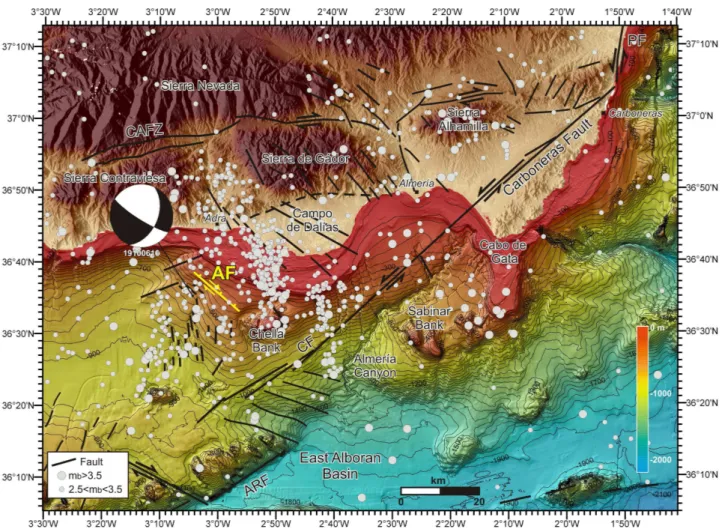
Fig. 7.Topographic and colour-shaded bathymetric map (isobaths every 50 m) of the Almer´ıa–Adra margin. Seismicity from the Instituto Geogr´afico Nacional catalogue for the period between 1965 and 2010 is depicted (I.G.N., 2010). Grey dots correspond to epicentres of earthquakes for different magnitudes. Main active faults onshore and offshore are located in black. The normal-dextral Adra Fault is depicted in yellow. Moment tensor solution obtained for the 1910 Adra Earthquake is also located (Stich et al., 2003b). CAFZ: Corredor de las Alpujarras Fault Zone; CF: Carboneras Fault; PF: Palomares Fault; ARF: Adra Ridge Fault.
the seismic potential of the Adra Fault, we measured the fault dimensions (length, strike, and dip) of the segments and of the overall fault, we estimated their minimum and maximum seismogenic depths, and we calculated their width and surface area. Considering maximum segment lengths of 18.5±0.2 km for the whole Adra Fault and 9.4±0.2 km for the longest eastern segment, a sub-vertical fault dip at 80◦±10◦, a rake of −135◦, and a maximum seismogenic
depth of 15 km, we obtained maximum rupture surfaces of 281.78 km2and 143.18 km2, respectively. To obtain seismic parameters, we used the empirical relationship of Wells and Coppersmith (1994) for strike-slip faults relating the surface area with the maximum magnitude, asMw=4.07+0.98× logA, where A is the rupture area. The maximum values obtained are Mw=6.47±0.24 for the total length of the Adra Fault andMw=6.18±0.24 for the eastern segment. These fault parametres are of considerable interest to the
seismic hazard assessment models of the Iberian Peninsula (e.g. Nemser et al., 2010).
event. The best fitting moment tensor solution corresponds to a seismic momentM0=1.50×10¹⁸Nm and a moment mag-nitude ofMw=6.1 oblique strike-slip event at 16 km depth, although the depth resolution for this event is low due to the small number of recordings. In agreement with the available neotectonic and seismotectonic data, the preferred faulting solution strikes 122◦, dips 80◦ and rakes−137◦(Stich et al., 2003b). The deconvolution of the aftershock yields the rela-tive source time function, which indicates a total rupture time of 4.5 s, corresponding to estimates for mainshock rupture length of 12 km.
Linking historical earthquakes with fault sources is not an easy task, since detailed information about the epicentre is sparse or null and the coseismic surface ruptures accompa-nying an historical earthquake may not be preserved (Am-braseys, 1975). This is even more complex in marine areas, where only in few cases has the fault source been success-fully found (e.g. Elias et al., 2007). Considering the macro-seismic intensity pattern (Vidal, 1986) and the epicentre re-location (Stich et al., 2003b), the Adra event (Figs. 1 and 7) falls relatively close (given location uncertainties) to the sub-merged trace of the Adra Fault as mapped in the present study (Fig. 7), discarding the sources located onshore (i.e. Balane-gra Fault). In addition, this is the only fault identified near the epicentral location with large enough dimensions capable of generating an earthquake of this magnitude. Finally, fault seismic parameters of the Adra Fault are consistent with the moment tensor calculations (Stich et al., 2003b) with respect to the preferred NW–SE trending fault plane, fault plane di-mension and normal-dextral solution. All this suggests that the Adra Fault is the most plausible source of theMw=6.1 1910 Adra Earthquake event.
6 Conclusions
1. High-resolution acoustic and seismic data from the Almer´ıa margin together with14C dating from a sedi-ment core of the area allowed us to identify and char-acterize a new fault in the NE Alboran Sea, which we termed the Adra Fault. The superficial expression of the Adra Fault consists of an upwarped narrow deformation zone bounded by sub-vertical faults that trend N130 and extend for more than 18 km ending in a volcanic ridge of the Chella Bank. A narrow stepover separates the par-allel western and eastern segments of the Adra Fault. 2. The Adra Fault cuts and folds the most recent
sed-imentary units of late Holocene age, indicating that it corresponds to an active structure. Considering the NNW–SSE regional shortening axis between Eurasia and Africa, the Adra Fault may have a normal-dextral component as the faults onshore Campo de Dal´ıas (i.e. Loma del Viento Fault). These structures may be consis-tent with the model of block tectonic escape suggested by Mart´ınez-D´ıaz and Hern´andez Enrile (2006).
3. Despite the low seismic activity recorded along the Adra Fault trace, our data suggest that this structure is a potential source of large magnitude (up toMw∼6.5) events and it is a very likely source of the 1910 Adra Earthquake. This is corroborated by the proximity of the Adra Fault to the earthquake epicentre and by the good fit between the fault parameters and the fault solution obtained from the seismic moment tensor. Seismic and tsunami hazard in the southeast Iberia and African mar-gins would significantly increase if offshore structures such as the Adra Fault are considered.
Acknowledgements. The authors acknowledge the support of the Spanish Ministry of Science and Innovation (MICINN) through National Projects IMPULS (REN2003-05996MAR), EVENT (CGL2006-12861-C02-02) and SHAKE (CGL2011-30005-C02-02); Acciones Complementarias EVENT-SHELF (CTM 2008-03346-E/MAR) and SPARKER (CTM 2008-03208-E/MAR) and the ESF TopoEurope TOPOMED project (CGL2008-03474-E/BTE). We thank the captain, crew, scientific party and technical staff of the UTM-CSIC on board the Spanish R/V “Hesperides” and R/V “Garc´ıa del Cid” during the IMPULS and EVENT-SHELF cruises, respectively. We thank Fabrizio Pepe (Univ. Palermo) for his assistance in using the Geotrace software. We thank guest editor Hans Nelson, Carlos Mar´ın Lechado and an anonymous referee for constructive comments and reviews. This work has been carried out withinGrup de Recerca de la Generalitat de CatalunyaB-CSI (2009 SGR 146).
Edited by: H. Nelson
Reviewed by: C. Marin Lechado and one anonymous referee
References
Alfaro, P., Delgado, J., Est´evez, A., Soria, J. M., and Y´ebenes, A.: Onshore and offshore compressional tectonics in the eastern Betic Cordillera (SE Spain), Mar. Geol., 186, 337–349, 2002. Ambraseys, N. N.: Studies in historical seismicity and tectonics, in:
Geodynamics of Today, Royal Society of London, 9–16, 1975. Argus, D. F., Gordon, R. G., DeMets, C., and Stein, S.: Closure
of the Africa- Eurasia-North America plate motion circuit and tectonics of the Gloria fault, J. Geophys. Res., 94, 5585–5602, 1989.
Ballesteros, M., Rivera, J., Mu˜noz, A., Mu˜noz-Mart´ın, A., Acosta, J., Carb´o, A., and Uchupi, E.: Alboran Basin, southern Spain – Part II: Neogene tectonic implications for the orogenic float model, Mar. Petr. Geol. 25, 75–101, 2008.
Bartolome, R., Lo Iacono, C., and Gr`acia, E.: Multiscale seismic imaging of active faults at sea, Sea-Technol., 50, 10–14, 2009. Bousquet, J. C.: Quaternary strike-slip faults in southeastern Spain,
Tectonophysics, 52, 277–286, 1979.
Buforn, E., Sanz de Galdeano, C., and Ud´ıas, A.: Seismotectonics of Ibero-Maghrebian region, Tectonophysics, 248, 247–261, 1995. Buforn, E., Bezzeghoud, M., Ud´ıas, A., and Pro, C.: Seismic
Comas, M. C., Platt, J. P., Soto, J. I., and Watts, A. B.: The origin and tectonic history of the Alboran Basin: insights from leg 161 results, in: Proc. ODP, Sci. Res., 161, Ocean Drilling Program, College Station, USA, 555–580, 1999.
DeMets, C., Gordon, R. G., and Argus, D. F.: Geologically current plate motions, Geophys. J. Int., 181, 1–80, 2010
Elias, A., Tapponier, P., Singh, S. C., King, G. C. P., Briais, A., Da¨eron, M., Carton, H., Sursock, A., Jacques, E., Jomaa, R., and Klinger, Y.: Active thrusting offshore Mount Lebanon: Source of the tsunamigenic A.D. 551 Beirut-Tripoli earthquake, Geology, 35, 755–758, 2007.
Fern´andez-Salas, L. M., Dabrio, C. J., Goy, J. L., D´ıaz del R´ıo, V., Zazo, C., Lobo, F. J., Sanz, J. L., and Lario, J.: Land–sea corre-lation between late Holocene coastal and infralittoral deposits in the SE Iberian Peninsula (Western Mediterranean), Geomorphol-ogy, 104, 4–11, 2009.
Gr`acia, E., Pall`as, R., Soto, J. I., Comas, M., Moreno, X., Masana, E., Santanach, P., Diez, S., Garc´ıa, M., and Da˜nobeitia, J. J.: Ac-tive faulting offshore SE Spain (Alboran Sea): Implications for earthquake hazard assessment in the Southern Iberian Margin, Earth Planet. Sci. Lett., 241, 734–749, 2006.
Gr`acia, E., Vizcaino, A., Escutia, C., Asioli, A., Rod´es, A., Pall`as, R., Garcia-Orellana, J., Lebreiro, S., and Goldfinger, C.: Holocene earthquake record offshore Portugal (SW Iberia): Test-ing turbidite paleoseismology in a slow-convergence margin, Quat. Sci. Rev., 29, 1156–1172, 2010.
I.G.N.: Cat´alogo s´ısmico nacional hasta el 2010, Instituto Geogr´afico Nacional, Madrid, http://www.ign.es/ign/layoutIn/ sismoFormularioCatalogo.do, 2010.
Jim´enez-Munt, I. and Negredo, A. M.: Neotectonic modelling of the western part of the Africa-Eurasia plate boundary: from the Mid-Atlantic ridge to Algeria, Earth Planet. Sci. Lett., 205, 257–271, 2003.
Jurado, M. J. and Comas, M. C.: Well log interpretation and seismic character of the Cenozoic sequence in the northern Alboran Sea, Geo-Marine Lett., 12, 129–136, 1992.
Khazaradze, G., Moreno, X., Asensio, E., and Masana, E.: Resul-tados preliminares de actividad de la falla de Carboneras (Betica Orientales) mediante GPS, in: Contribuci´on de la Geolog´ıa al An´alisis de la Peligrosidad S´ısmica, 205, Sig¨uenza (Guadalajara, Espa˜na), 2010.
Keller, J. V. A., Hall, S. H., Dart, C. J., and McClay, K. R.: The geometry and evolution of a transpressional strike-slip system: the Carboneras fault, SE Spain, J. Geol. Soc. London, 152, 339– 351, 1995.
Lo Iacono, C., Gr`acia, E., Diez, S., Bozzano, G., Moreno, X., Da˜nobeitia, J., and Alonso, B.: Seafloor characterization and backscatter variability of the Almer´ıa Margin (Alboran Sea, SW Mediterranean) based on high-resolution acoustic data, Mar. Geol., 250, 1–18, 2008.
Mar´ın-Lechado, C., Galindo-Zald´ıvar, J., Rodr´ıguez-Fern´andez, L. R., Serrano, I., and Pedrera, A.: Active faults, seismicity and stresses in an internal boundary of a tectonic arc (Campo de Dal´ıas and N´ıjar, southeastern Betic Cordilleras, Spain), Tectonophysics, 396, 81–96, 2005.
Mar´ın-Lechado, C., Galindo-Zald´ıvar, J., Rodr´ıguez-Fern´andez, L. R., and Pedrera, A.: Mountain front development by folding and crustal thickening in the internal zone of the Betic Cordillera-Alboran Sea Boundary, Pure Appl. Geophys., 164, 1–21, 2007.
Mart´ınez-D´ıaz, J. J.: Neotect´onica y tect´onica activa del sector centro-occidental de Murcia y Sur de Almer´ıa, Cordillera B´etica (Espa˜na), Ph.D. thesis, Universidad Complutense de Madrid, 466 pp., 1998.
Mart´ınez-D´ıaz, J. J. and Hern´andez-Enrile, J. L.: Neotectonics and morphotectonics of the southern Almer´ıa region (Betic Cordillera-Spain) kinematics implications, Int. J. Earth. Sci., 93, 189–206, 2004.
Mart´ınez-D´ıaz, J. J., Masana, E., Hern´andez-Enrile, J. L., and San-tanach, P.: Evidence for coseismic events of recurrent prehis-toric deformation along the Alhama de Murcia Fault, southeast-ern Spain, Acta Geol. Hispanica, 36, 315–327, 2001.
Masana, E., Mart´ınez-D´ıaz, J. J., Hern´andez-Enrile, J. L., and San-tanach, P.: The Alhama de Murcia fault (SE Spain), a seismo-genic fault in a diffuse plate boundary: Seismotectonic impli-cations for the Ibero–Magrebian region, J. Geophys. Res., 109, 1–17, 2004.
Masana, E., Pall`as, R., Perea, H., Ortu˜no, M., Mart´ınez-D´ıaz, J. J., Garc´ıa-Mel´endez, E., and Santanach, P.: Large Holocene mor-phogenic earthquakes along the Albox Fault, Betic Cordillera, Spain, J. Geodyn., 40, 119–133, 2005.
McCalpin, J.: Paleoseismology, Academic Press cop., San Diego, 588 pp., 1996.
MEDIMAP Group, Loubrieu, B., and Mascle, J.: Morpho-bathymetry of the Mediterranean Sea, Map CIESM edition, 2008.
Moreno, X.: Neotectonic and Paleoseismic onshore-offshore inte-grated study of the Carboneras Fault (Eastern Betics, SE Iberia), Ph.D. thesis, Universitat de Barcelona, 365 pp., 2011.
Moreno, X., Masana, E., Gr`acia, E., Bartolom´e, R., and Piqu´e-Serra, O.: Estudio paleosismol´ogico de la Falla de Carboneras: Evidencias tierra-mar de actividad tect´onica reciente, GeoTemas, 10, 1035–1038, 2008.
Mu˜noz, A., Ballesteros, M., Montoya, I., Rivera, J., Acosta, J., and Uchupi, E.: Alboran Basin, southern Spain—Part I: Geomor-phology, Mar. Petr. Geol. 25, 59–73, 2008.
Nemser, E. S., Garc´ıa-Mayordomo, J., Cabral, J., Fonseca, J. F. B. D., Mart´ınez-D´ıaz, J. J., Vilanova, S., and 2010 Working Group on Iberian Seismogenic Sources: Compilation of parameterized seismogenic sources in Iberia for the SHARE European-scale seismic source model, in: Contribuci´on de la geolog´ıa al an´alisis de la peligrosidad s´ısmica, 201–204, 2010.
Pantosti, D. and Yeats, R. S.: Paleoseismology of great earthquakes of the late Holocene, Ann. Geofis., 36, 237–257, 1993.
Pedrera, A., Mar´ın-Lechado, C., Stich, D., Ruiz-Const´an, A., Galindo-Zald´ıvar, J., Rey-Moral, C., and Mancilla, F. L.: Nu-cleation, linkage and active propagation of a segmented Qua-ternary normal-dextral fault: the Loma del Viento fault (Campo de Dal´ıas, Eastern Betic Cordillera, SE Spain), Tectonophysics, 522–523, 208–217, 2012.
Pel´aez, J. A. and L´opez Casado, C.: Seismic hazard estimate at the Iberian Peninsula, Pure Appl. Geophys., 159, 2699–2713, 2002. Perea, H., Gr`acia, E., Alfaro, P., Bartolom´e, R., Lo Iacono, C., Moreno, X., Masana, E., and EVENT-SHELF Team: Quaternary active tectonic structures in the offshore Bajo Segura basin (SE Iberian Peninsula – Mediterranean Sea), Nat. Hazards Earth Syst. Sci., in press, 2012.
Ed-wards, R. L., Friedrich, M., Grootes, P. M., Guilderson, T. P., Ha-jdas, I., Heaton, T. J., Hogg, A. G., Hughen, K. A., Kaiser, K. F., Kromer, B., McCormac, F. G., Manning, S. W., Reimer, R. W., Richards, D. A., Southon, J., Turney, C. S. M., van der Plicht, J., and Weyhenmeyer, C.: IntCal09 and Marine09 Radiocarbon Age Calibration Curves, 0–50 000 Years cal BP, Radiocarbon, 51, 1111–1150, 2009.
Rodr´ıguez-Fern´andez, J. and Mart´ın-Penela, J.: Neogene evolution of the Campo de Dal´ıas and surrounding offshore areas (North-eastern Alboran Sea), Geodin. Acta, 6, 255–270, 1993.
Sanz, J. L., Tello, O., Hermida, N., Fern´andez-Salas, L. M., Gonz´alez, J. L., Pastor, E., B´ecares, M. A., Cubero, P., Godoy, D., Alcal´a, C., Contreras, D., Frias, A.J., Ramos, M., Torres, A., Ubiedo, J. M., Alfageme, V. M., Carre˜no, F., Pascual, L., P´erez, J. I., Redondo, B. C., Velasco, D., and Gonz´alez, F.: Aguadulce a Balanegra (Almer´ıa), Serie cartogr´afica Estudio de la Plataforma continental Espa˜nola, Ministerio de Agricultura, Pesca y Al-imentaci´on, Secretar´ıa General de Pesca Mar´ıtima – Instituto Espa˜nol de Oceanograf´ıa, Maps MC052 and MC053, 2004. Sanz de Galdeano, C.: Geologic evolution of the Betic Cordilleras in
the Western Mediterranean, Miocene to present, Tectonophysics, 172, 107–119, 1990.
Silva, P. G., Goy, J. L., Somoza, L., Zazo, C., and Bardaj´ı, T.: Land-scape response to strike-slip faulting linked to collisional set-tings: Quaternary tectonics and basin formation in the Eastern Betics, southeastern Spain, Tectonophysics, 224, 289–303, 1993. Sylvester, A. G.: Strike-slip faults, Geol. Soc. Am. Bull., 100, 1666–
1703, 1988.
Stich, D., Alguacil, G., and Morales, J.: The relative locations of multiplets in the vicinity of the Western Almer´ıa (southern Spain) earthquake series of 1993–1994, Geophys. J. Int., 146, 801–812, 2001.
Stich, D., Ammon, C. J., and Morales, J.: Moment tensor solutions for small and moderate earthquakes in the Ibero-Maghreb region, J. Geophys. Res., 108, 2148–2168, 2003a.
Stich, D., Batll´o, J., Morales, J., Maci`a, R., and Dineva, S.: Source parameters of theMw = 6.1 1910 Adra earthquake (southern Spain), Geophys. J. Int., 155, 539–546, 2003b.
Stich, D., Serpelloni, E., Mancilla, F., and Morales, J.: Kinematics of the Iberia–Maghreb plate contact from seismic moment ten-sors and GPS observations, Tectonophysics, 426, 295–317, 2006. Stich, D., Mart´ın, R., and Morales, J.: Moment tensor inversion for Iberia–Maghreb earthquakes 2005–2008, Tectonophysics, 483, 390–398, 2010.
Stuiver, M. and Reimer, P. J.: Extended14C data base and revised CALIB 3.014C age calibration program, Radiocarbon, 35, 215– 230, 1993.
Vidal, F.: Sismotect´onica de la regi´on de las B´eticas-Mar de Albo-ran, PhD Thesis, University of Granada, Granada, 450 pp., 1986. Wallace, R. E.: Active faults, paleoseismology and earthquake haz-ards in the western United States, in: Earthquake prediction: An international review, Am. Geophys. Union, Washington, USA, 209–216, 1981.
Wells, D. L. and Coppersmith, K. J.: New empirical relationships among magnitude, rupture length, rupture width, and surface dis-placement, Bull. Seism. Soc. Am., 84, 974–1002, 1994. Zazo, C., Goy, J. L., Dabrio, C. J., Bardaj´ı, T., Hillarie-Marcel, C.,