Precambrian Research 92 (1998) 251–275
A structural transect across the coastal mobile belt in the Brazilian
Highlands ( latitude 20
°
S ): the roots of a Precambrian
transpressional orogen
Dickson Cunningham
a,
*, Fernando F. Alkmim
b
, Stephen Marshak
c
aOrogenic Processes Group, Department of Geology, University of Leicester, Leicester, LE1 7RH, UK bDepartamento de Geologia, Universidade Federal de Ouro Preto, Ouro Preto, Brazil
cDepartment of Geology, University of Illinois, Champaign-Urbana, IL, USA Received 15 October 1997; received in revised form 8 June 1998; accepted 8 June 1998
Abstract
We present results of a detailed structural analysis from a 250 km-long, east–west-trending transect crossing the Coastal Mobile Belt, a part of the Precambrian orogen which lies between the eastern edge of the Sa˜o Francisco craton and the Atlantic coast. The region exposes amphibolite–granulite grade metamorphic rocks and migmatites which formed at mid-lower crustal depths during the Brasiliano orogeny (0.63–0.52 Ga). This event marked the closure of the northernmost Adamastor Ocean and collision between the Sa˜o Francisco and Congo Cratons during West Gondwana assembly. Brasiliano deformation resulted in W-vergent structures including thrust faults which accommodated kilometer-scale transport of crystalline basement, overturned kilometer-scale folds, sheath folds and penetratively developed gneissosity and schistosity. Isolated relics of an older folded fabric occur locally and may represent Transamazonian (2.2–2.0 Ga) deformation. The orogen is kinematically partitioned with the eastern 175 km dominated by moderately- to steeply dipping north-trending dextral strike-slip and oblique-slip faults and associated flower structures, whereas the western 75 km is dominated by W-vergent shallowly- to moderately east-dipping thrust faults. The boundary between these two provinces may mark a Brasiliano suture. Throughout the transect, quartzite and metasedimentary belts form strongly deformed zones between massive crystalline basement thrust sheets. The granulite-cored Serra do Caparau` massif, the highest mountains in South America outside of the Andes and Guyana shield, occupies a restraining bend between two Brasiliano dextral shear zones. The W-vergent Coastal Mobile Belt formed contiguously with the E-vergent Pan-African West Congo orogen now exposed along the conjugate margin of Africa. Thus an important late Precambrian boundary between structurally linked but kinematically opposed structural provinces must lie hidden in the extended offshore continental margins of either continent. Cretaceous opening of the South Atlantic and separation of the West Congo belt from the Coastal Mobile Belt may have been structurally influenced by this boundary. © 1998 Elsevier Science B.V. All rights reserved.
Keywords: Coastal Mobile Belt; Brazil; Transpression; Gondwana Assembly
* Corresponding author. Tel.:+44 116 2523649; Fax:+44 116 2523918; e-mail: wdc2@le.ac.uk
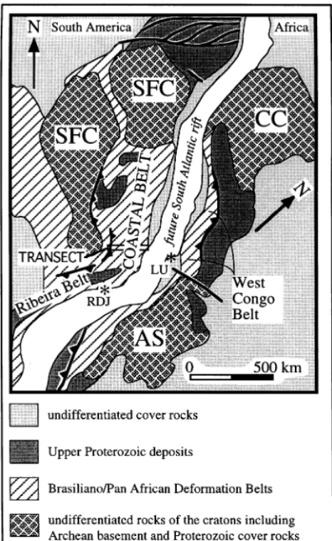
1. Introduction uplifted shoulder and subsided continental shelves of both continents ( Fig. 2).
The Coastal Mobile Belt has also been called This study provides new observations from a
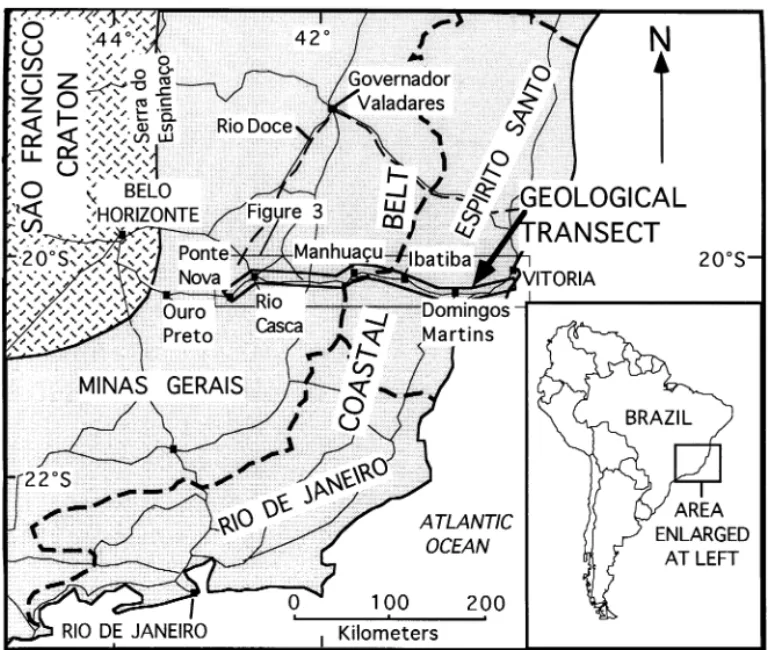
250 km-long east–west-trending structural transect the Ribeira Belt by some previous workers (e.g. Machado et al., 1996) and confusion exists in the across the Coastal Mobile Belt in eastern Brazil
(Fig. 1). This belt comprises a portion of the literature over the correct terminology for the different Precambrian belts in eastern Brazil. At Brazilian Highlands which lies between the
Archean Sa˜o Francisco craton and the Atlantic first order, the Proterozoic deformation belt between 32°S and 15°N is called the Mantiqueira Ocean margin in the states of Minas Gerais and
Espirito Santo (Fig. 1), and thus is a relict of one Province (Almeida, 1977). The Ribeira Belt is a subdivision of the Mantiqueira Province and is
of the many Transamazonian (2.0 Ga) or
Brasiliano (0.63–0.52 Ga; =Pan African) mobile commonly regarded as the Precambrian mobile belt which parallels the eastern coast of Brazil belts which surround cratonic nuclei of Gondwana
(Fig. 2). Prior to the Cretaceous opening of the from Rio de Janeiro southwards. North of Rio de Janeiro, lithologic correlations between the defor-South Atlantic, the Coastal Mobile Belt was
con-nected to the Pan African West Congo Belt mation belts east of the Sao Francisco craton and the Ribeira Belt to the south are unclear. Thus (Schermerhorn, 1981; Porada, 1989;
Pedrosa-Soares et al., 1992; Maurin, 1993). Together, these this northernmost portion of the Mantiqueira Province is usually subdivided into a western zone, belts represent opposite sides of a once larger
orogen whose internal zones occur within the the Arac¸uai Belt (Almeida and Hasui, 1984) and
253 D. Cunningham et al./Precambrian Research 92 (1998) 251–275
level exposure of the crystalline roots of a poly-phase Neoproterozoic orogen. Previous work in the region has largely focused on the petrology and geochemistry of the basement rocks without an understanding of their regional structural framework. Thus the primary objective of this study is to provide for the first time, the detailed structural architecture of the Coastal Mobile Belt from meso-scale to regional-scale. This study is also important because the region provides a natu-ral laboratory for understanding the geometry and style of compressional and transpressional defor-mation at 15–25 km depths and the manner in which strain is partitioned in the mid-lower crust. The Coastal Mobile Belt marks the location of Neoproterozoic–early Phanerozoic closure of the northernmost Adamastor Ocean and collision between the Sa˜o Francisco and Congo cratons (Hartnady et al., 1985). Thus an additional aim of this study is to better understand the sequence of events which led to closure of the northernmost Adamastor Ocean and the kinematic evolution of the collision zone in the wider regional context of Gondwana assembly.
2. Previous work in the coastal mobile belt
Fig. 2. Jurassic Gondwana reconstruction prior to the opening Previous work on the detailed geology of the of the South Atlantic showing positions of major cratons and
Coastal Mobile Belt includes regional lithologic, Brasiliano/Pan African mobile belts. Coastal and West Congo
petrologic, geochronologic and geophysical data belts are adjacent to each other and structurally linked. AS,
gathered during the Radambrasil Project
Angola Shield; CC, Congo Craton; SFC, Sa˜o Francisco Craton;
RDJ, Rio De Janeiro; LU, Luanda. (Machado Filho et al., 1983) and 1:100 000 geo-logic mapping and petrogeo-logic, geochronogeo-logic, structural and geophysical investigations for some areas in eastern Minas Gerais and Espı´rito Santo
an eastern zone, the Coastal Mobile belt
(Mascarenhas, 1979) or Atlantic Belt (Leonardos states by Companhia de Pesquisa de Recursos Minerais (CPRM ). Extensive petrologic and geo-and Fyfe, 1974). We prefer to use the term Coastal
Mobile Belt for the area investigated here (Fig. 1) chronologic studies were carried out on metamor-phic assemblages and igneous complexes between as used originally by Mascarenhas (1979) and
more recently Wiedemann (1993). Ouro Preto and Vitoria ( Fig. 1) by various
German workers in the 1980s including Sluitner The Coastal Mobile Belt exposes
amphibo-lite–granulite-grade metamorphic rocks and igne- and Weber-Diefenbach (1989), So¨llner et al. (1987, 1989), Bayer et al. (1986), Bayer (1987), Herbert ous complexes which formed at mid-lower crustal
levels during multiple phases of magmatism and et al. (1991), Schulz-Kuhnt et al. (1990) and Jordt-Evangelista and Mu¨ller (1986). A synthesis of all compressional and transpressional deformation
Coastal Mobile Belt which contains a model for the Congo–Sa˜o Francisco cratons in the Coastal Mobile Belt region by Trompette (1997).
the crustal evolution of the region is provided by So¨llner et al. (1991). Machado et al. (1996) pub-lished U–Pb data from the Coastal Mobile Belt in
Rio de Janeiro state and determined that the 3. Methodology
Coastal Mobile Belt attained peak metamorphic
conditions at 590–565 Ma during Brasiliano defor- Our study differs from previous studies in the region because our structural transect involved mation with youngest ages of deformation and
metamorphism in the easternmost domains. studying every available rock and saprolite outcrop (>450 outcrops) along a 250 km length of highway Previous structural studies of the Coastal Mobile
Belt are limited, especially in eastern Minas Gerais (MG262 and BR262) with additional outcrop study along nearby roads and streams. Thus this and Espı´rito Santo at the latitude of this study.
Quadrangle maps by CPRM (1:100 000) which study greatly condenses a considerable amount of outcrop information. Although existing regional cover most of Espı´rito Santo and some of eastern
Minas Gerais provide information on important lithotectonic subdivisions are acknowledged ( Fig. 3), we prefer to report our lithological and faults and regional structural trends. Bayer (1987)
published an important monograph documenting structural data without a genetic bias.
Exposure along the transect varies in quality separate structural events which have affected the
region. Campos Neto and Figueiredo (1995) pub- from abundant fresh rock exposures in the high-lands between Pequia´ and Viana (Fig. 3) to limited lished geochemical, geochronological and
struc-tural data for the region that suggest Brasiliano fresh exposure but abundant deeply weathered saprolite exposures (which preserve structures) deformation involved accretion of different
micro-plates and development of a short-lived magmatic between Ponte Nova and Pequia´. Between Viana and the coast, outcrops are scarce due to extensive arc [see also Wiedemann (1993)].
Other important structural studies from the Cenozoic sedimentary cover. Good quality
1:50 000 topographic maps produced by IBGE Coastal Mobile Belt outside of the area
investi-gated here include Pedrosa-Soares et al. (1992) (Instituto Brasileiro de Geografia e Estatı´stica) were used as basemaps for recording outcrop who proposed that the Arac¸uai belt represents a
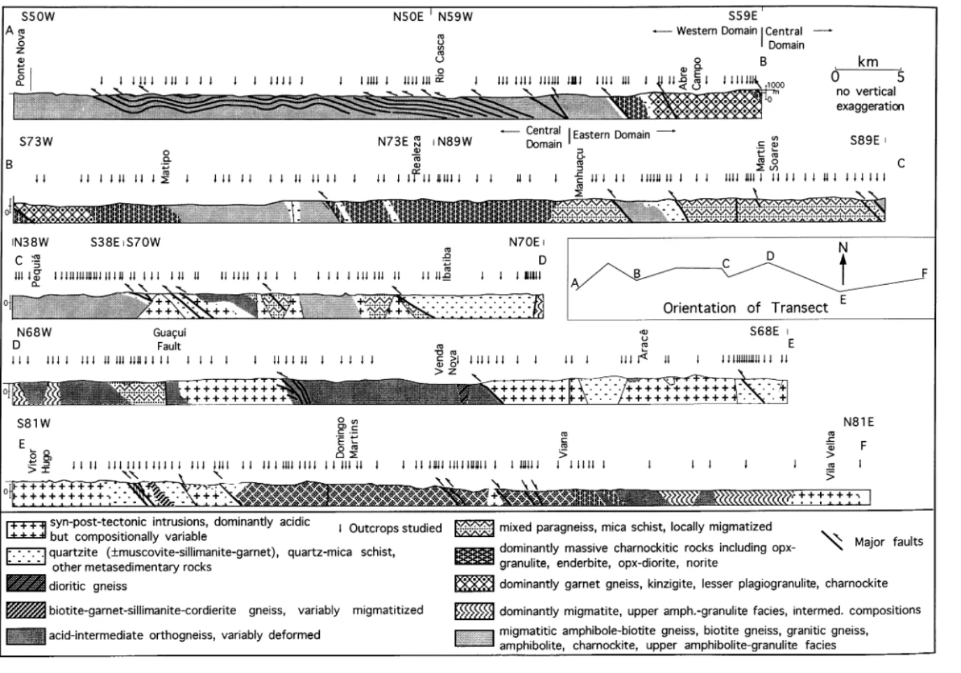
closed Red Sea type basin with an ophiolitic suture locations. The transect data were plotted on a single continuous cross-section divided into eight zone and Cunningham et al. (1996) who
docu-mented the structural style of Brasiliano basin linear connecting sections ( Figs. 3–5) which approximate the direction of MG262 and BR262. closure and inversion in the Governador Valadares
region (Fig. 1). Haralyi and Hasui (1982) pre- Outcrop data which do not fall directly on the transect line were projected onto the cross-section sented regional gravity data for eastern Brazil
which included a discussion of the crustal structure along the strike. of the northern Coastal Mobile Belt.
Important regional studies concerning the
tectonic evolution of eastern South America 4. Observations
includes Brito Neves and Cordani (1991) on the
Proterozoic assembly and evolution of the entire 4.1. Structural domains of the transect
South American continent, an overview of
Precambrian terranes of eastern South America by The transect begins ca 80 km east of the south-east corner of the Sa˜o Francisco craton and termi-Bernasconi (1987), a discussion of Proterozoic
Transamazonian belts by Bertrand and Jardim de nates at the South Atlantic coast. Thus, it provides an across-strike account of the Proterozoic mobile Sa´ (1990), a summary of Brazil–Africa geological
links by Torquato and Cordani (1981), Porada belt which lies between the Sa˜o Francisco craton and the Mesozoic rifted margin of South America.
(1979, 1989) and an overview of western
west-255
D.
Cunningham
et
al.
/
Precambrian
Research
92
(
1998
)
251
–
275
D.
Cunningham
et
al.
/
Precambrian
Research
92
(
1998
)
251
–
275
257
D.
Cunningham
et
al.
/
Precambrian
Research
92
(
1998
)
251
–
275
ern, central and eastern, based on differences in 4.2. Western domain lithologic content and structural style (Figs. 4–6).
The western domain is distinguished by amphibo- 4.2.1. Lithologic assemblages
Bedrock in the western domain ( Fig. 4)
lite to granulite facies gneisses and migmatites cut
by W-vergent low- to moderate-angle thrust zones. consists mostly of migmatitic biotite–amphibole orthogneiss, whose bulk composition ranges from The central domain is dominated by charnockitic
rocks and steep faults and foliation attitudes. The granodiorite to tonalite (e.g. Herbert et al., 1991; Schulz-Kuhnt et al., 1990; Brandalise, 1991; Jordt-eastern domain is characterized by diverse
meta-morphic and plutonic complexes deformed by Evangelista and Mu¨ller, 1986; Teixeira et al., 1987). In general, these gneisses contain a mineral W-vergent contractional and transpressional
struc-tures and overprinting dextral strike-slip zones. assemblage indicative of amphibolite facies, but from west to east across the domain, the rocks We describe the rock units and structural features
of each domain from west to east as shown on contain increasing amounts of plagioclase, biotite, and amphibole, and granulite-grade rocks occur Figs. 4 and 5.
259 D. Cunningham et al./Precambrian Research 92 (1998) 251–275
in a belt beginning 10 km west of Abre Campo Group (Jordt-Evangelista, 1992; Brandalise, 1991; Cunningham et al., 1996). At the latitude of this (Herbert et al., 1991). In addition, migmatitic
granitic gneiss occurs in a belt between 5 and transect, however, the Dom Silve´rio Group lies to the west of our western domain (west of Ponte 20 km west of Abre Campo. Multiple generations
of both undeformed and deformed pegmatite dikes Nova). Thus we suggest that rocks of the western domain correlate with the Transamazonian base-as well base-as boudinaged amphibolite dikes and sills
occur in all rocks of the western domain, giving ment of the Piedade Gneiss which was remetamor-phosed and penetratively deformed during the outcrops a heterogeneous appearance.
The granulitic rocks along the eastern edge of Brasiliano event. the western domain include north–south-trending
slices of enderbite, amphibolite, quartzite and 4.2.2. Structural geology
The biotite–amphibole gneiss which underlies garnet quartzo-feldspathic tonalitic gneiss (Mu¨ller
et al., 1991). The enderbite is brownish-green, the western two-thirds of the western domain records a complex deformational history. This granoblastic, and unfoliated to strongly foliated.
Upper amphibolite-grade quartzite slices (contain- rock is well banded, contains one dominant folia-tion and commonly contains pinch and swell struc-ing muscovite, sillimanite and 80–90% quartz)
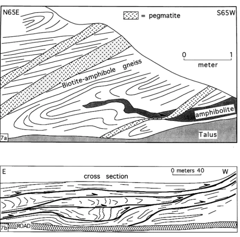
separate gneiss bodies from one another. A coarse- tures, boudinage, high-strain shear zones and sheared pegmatite sheets [Fig. 7(a)]. Foliation grained garnet paragneiss containing bluish quartz
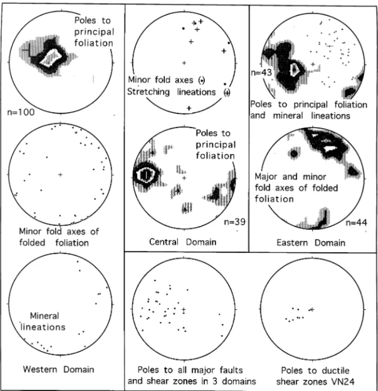
crops out at Abre Campo. This unit, as well as undulates around horizontal or dips gently to the east ( Figs. 5 and 6). Foliation intensity, as defined the quartzite slices, can be traced along strike for
at least 100 km (cf Cunningham et al., 1996) and qualitatively by thickness of bands, density of planes, the degree of preferred orientation of mica, thus are useful markers for defining regional
structure. and the continuity of bands, varies both regionally
and within an outcrop (we consider rock with Rocks of the western domain have been
alterna-tively correlated with the Archean Mantiqueira thinner, densely concentrated bands, stronger pre-ferred orientation of mica, and more continuous gneiss (Brandalise, 1991), or the Proterozoic
Piedade gneiss ( Ebert, 1968; Machado Filho et al., banding to be more intensely foliated ). Locally, foliation is wavy and anastamosing, and strongly 1983). The Piedade gneiss has Transamazonian
Rb–Sr whole rock isochron ages and Brasiliano foliated intervals of gneiss surround more
weakly foliated, less micaceous phacoidal lenses Sm–Nd metamorphic ages (whole-rock, garnet,
feldspar; H. Brueckner, pers. comm., 1997) but no [Fig. 7(b)]. In these lenses, compositionally segre-gated quartzo-feldspathic bands with hornblende evidence for an Archean origin ( Teixeira, 1982;
Machado Filho et al., 1983). Conversely, geochro- and biotite folia are locally deformed into intrafol-ial folds or a discordant often more steeply dipping nological investigations of the Mantiqueira gneiss
indicate an Archean origin [2.76 Ga Jequie´ Cycle, foliation which represents either an early-formed Brasiliano fabric or relict Transamazonian fabric. Cordani et al. (1973) and Machado Filho et al.
(1983)] followed by upper amphibolite granulite- Locally, the gneisses also contain a shallowly plunging northeast-trending mineral lineation facies recrystallization during the Transamazonian
event [2.0 Ga, Machado Filho et al. (1983)] and defined by biotite aggregates. The kinematic signi-ficance of this lineation is unclear as it is generally greenschist to amphibolite facies metamorphism
and reworking during the Brasiliano event subparallel to the strike of the shallowly dipping foliation and at a high angle to the westerly [0.6–0.5 Ga, Jordt-Evangelista and Mu¨ller (1986)
and Schulz-Kuhnt et al. (1990) their Table 4]. direction of fold overturning and thrusting (see below). It could represent retrogressive post-North of our transect, the Mantiqueira gneiss is
separated from the Piedade Gneiss by a metasedi- thrusting strike-slip displacements on low-angle surfaces as documented further south by Vauchez mentary and metaigneous assemblage which
con-tains talc schist, serpentinite, and mafic and et al. (1994) but no other evidence was found to support this idea.
Fig. 7. (a) Outcrop sketch of SW-vergent isoclinally folded biotite-amphibole gneisses cut by undeformed to sheared and attenuated (arrow) syn- to post-tectonic pegmatite dikes. Location ca 5 km W of Rio Casca on MG262. Pegmatites in this area are numerous and commonly fill shear zones. (b) Outcrop sketch of road cut ca 14 km NE of Ponte Nova. Outcrop contains anastomosing system of ductile shear zones that step upwards towards the W and have accommodated top to W thrusting. Shear zones truncate folded foliation preserved in lenses that may be Transamazonian (2.0 Ga) in age.
Kilometer and outcrop-scale folds affect gneissic In the eastern third of the domain, gneissic foliation dips steeply to the east. Based on layering in the western two-thirds of the western
domain. West of Rio Casca (Fig. 5), the metamor- juxtaposition of contrasting lithologies (notably orthogneiss or enderbite placed over highly sheared phic banding is deformed into upright, open,
north–south-trending folds with wavelengths on and folded quartzites and schists), we documented several discrete top-to-the-west thrust faults in this the order of 1–5 km. East of Rio Casca, the
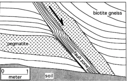
dominant metamorphic fabric is folded into tight region. Foliation within the narrow quartzite belts is intensely isoclinally folded; shear sense indicated to isoclinal and W-vergent folds [Fig. 8(a and b)].
Throughout the domain, minor centimeter to by the vergence of folds within the shear zones is uniformly to the west. Top-to-the-west shear sense meter scale folds within the gneiss are tight to
isoclinal, westerly inclined to recumbent and shal- is also indicated by asymmetric mafic boudins which are abundant in the western two-thirds of lowly plunging. West-closing mesoscopic sheath
261 D. Cunningham et al./Precambrian Research 92 (1998) 251–275
ing intensely folded and attenuated gneiss mark Quartzites of the central domain occur in several discrete, strongly foliated belts which tectonically other ductile thrust zones. Some of these
thrust-sense shear zones cut the principal folded fabric separate massive gneiss blocks. The quartzites contain minor amounts of muscovite, garnet, silli-indicating later and possibly lower temperature
retrogressive deformation [Fig. 8(c) and (d )]. manite and orthoclase. Locally, quartzite slivers contain isolated boudins of amphibolite, which possibly represent relics of flattened and sheared 4.3. Central domain
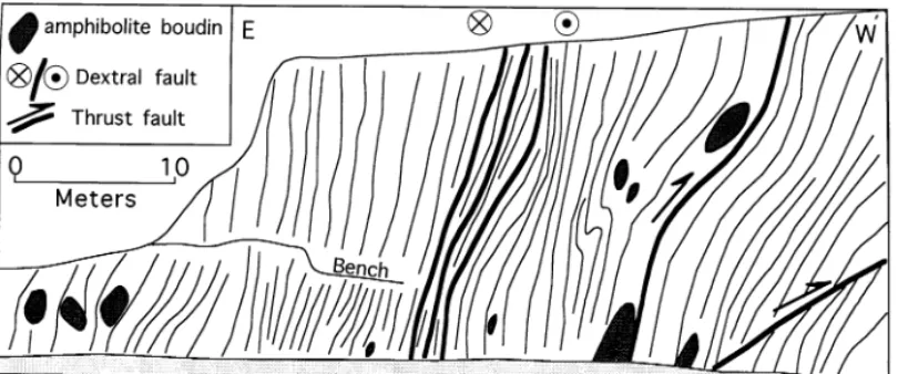
mafic dikes or sills ( Fig. 9). 4.3.1. Lithologic assemblages
Basement in this domain consists dominantly of 4.3.2. Structural geology
Throughout the central domain, metamorphic granulite-grade metamorphic rocks or quartzite of
which 75%are orthopyroxene-bearing rocks of the foliation dips steeply ( Figs. 5 and 6). However, dip direction varies from easterly to westerly, charnockite series ( Fig. 4). Rocks of this domain
have traditionally been correlated with the Juiz de locally creating asymmetric foliation fans which resemble the positive flower-structure geometry of Fora Complex which is defined as a diverse
assem-blage of medium- to high-grade charnockitic rocks transpressive shear zones (Fig. 5). The asymmetry of these apparent flower structures, oblique-slip and garnet–biotite gneisses (Almeida and Hasui,
1984). The charnockitic rocks (dominantly ender- NE-trending stretching lineations within the N-striking zones, and kinematic indicators suggest bite) are generally massive, variably foliated,
brownish-green and coarse-grained. Plagioclase is westward vergence coupled with a component of dextral strike-slip displacement (Figs. 6 and 9). the most important component with lesser
quanti-ties of bluish quartz, orthopyroxene, amphibole, Flower-like cleavage fans in the central domain occur in linear bands which have eroded to form biotite and garnet (Schulz-Kuhnt et al., 1990). The
charnockitic rocks are associated with, and locally valleys which stand out on satellite imagery as topographic lineaments. Because of their linear grade into, biotite–garnet gneiss and
clinopyro-xene-bearing amphibolite (Schulz-Kuhnt et al., nature and their component fabrics, we suggest that the flower-like cleavage domains define the 1990). They also occur as distinctive zones and
layers within biotite–garnet gneiss and locally con- traces of regional-scale ( length more than tens of kilometers) strike-slip or oblique-slip faults. One tain leucosomes, garnet-rich patches and angular,
fine-grained mafic xenoliths which give the rock of the largest of these zones is the Manhuac¸u fault which crops out ca 3 km west of the town of an agmatitic appearance. The majority of
orthopy-roxene-bearing rocks range from enderbitic (ton- Manhuac¸u ( Fig. 5) and is represented by a 1 km-wide zone of strongly developed steeply dipping-alitic) to noritic in composition (Herbert et al.,
1991). to vertical foliation within enderbitic gneisses.
Dextral shear sense is clear from asymmetric fabric Rocks in the central domain have not been
dated directly at the line of this transect. However, geometries and centimeter-scale folds of the folia-tion exposed in outcrops along the small river ages are available for correlative units along strike
elsewhere in Minas Gerais to the SSW. Rb–Sr which flows along the fault zone 10 km SSW of Manhuac¸u. The occurrence of these faults and the whole rock ages from similar granulites of the Juiz
de Fora Complex have yielded ages of ca 2.0 Ga regionally consistent steeply dipping foliation of the central domain provides the basis for distin-[i.e. Transamazonian; Cordani et al. (1980) and
Teixeira et al. (1987)]. No older ages of these rocks guishing it from the western domain.
As in the western domain, foliation intensity have yet been reported (So¨llner et al., 1991). Work
in progress by H. Brueckner, (pers. comm., 1997) varies with locality and lithology in the central domain. Charnockitic rocks tend to be blocky in indicates Brasiliano 562 Ma Sm–Nd ages (whole
rock, garnet, feldspar) for granulite metamorphism appearance and fracture conchoidally rather than along gneissic banding. We identified two separate in biotite–garnet gneiss 50 km north of Matipo
263 D. Cunningham et al./Precambrian Research 92 (1998) 251–275
Fig. 9. Outcrop sketch of dextral transpressional fault zone within massive layered supracrustal quartzite sequence 8 km W of Realeza on BR262.
the central domain, based on cross-cutting rela- ately west of the town of Matipo suggesting a local zone of east vergence ( Fig. 5).
tions. Both foliations are defined by the alternation of pyroxene+amphibole+biotite layers with
layers consisting of greenish brown plagioclase+ 4.4. Eastern domain quartz+minor garnet and biotite. Irregular zones
or bands of migmatite cut the older fabric, but 4.4.1. Lithologic assemblages
The eastern domain contains a wide variety of not the younger fabric, and the older fabric is
preserved as isoclinal fold hinges and attenuated metamorphic and plutonic rocks which have been variously ascribed to different complexes, terranes, limbs, whereas the younger fabric is planar or
wavy and pervasively developed. The older relict and assemblages by previous authors [Fig. 3, also see discussion in Bayer (1987)]. The justification fabric was not measured because of its
discontinu-ous and isoclinally folded nature. In contrast to for the various broad subdivisions is generally unclear and rather than using these conflicting and the enderbites, biotite–garnet gneiss tend to display
strong gneissosity, and fairly planar and con- overlapping unit names, we prefer to descriptively summarize lithologic packages of the Eastern tinuous banding. Quartzite bands display a very
closely spaced foliation defined by the alignment domain in sequence from west to east (see Figs. 3– 5 for locality names).
of flattened quartz grains and mica.
Kinematic indicators (e.g. extensional
crenula-tion cleavages, centimeter-scale asymmetric folds) 4.4.2. Manhuac¸u–Guac¸uı´ Fault
Lithologies between Manhuac¸u and the Guac¸uı´ within all major fault zones in the central domain
which we examined indicate top-to-the-west thrust Fault have been traditionally assigned to the Pochrane Complex (Manhuac¸u–Martins Soares) components of shearing. However, tight to
isocli-nal folds (with wavelengths of 10–100 m) with defined as biotite and hornblende gneisses, ortho-gneisses, migmatites, and subordinate schists and westerly dipping axial surfaces and associated
minor top-to-the-east shear zones occur immedi- quartzites (da Silva et al., 1987); Paraiba do Sul
Complex (Martins Soares–Ibatiba) defined as an Brueckner, pers. comm., 1997). Between the mig-matite and orthogneiss belt and the Guac¸uı´ Fault assemblage of high-grade gneisses and migmatites
with intercalations of metamorphosed supercrustal ( Figs. 3 and 4), a lithologic assemblage consisting of fine-grained biotite gneiss, mica schist and gray sediments including quartzites and marbles; or Juiz
de Fora Complex [Ibatiba–Guac¸uı´ fault, see previ- quartzitic gneiss crops out. Signorelli (1993) corre-lated this interval with other metasedimentary ous definition, Fig. 3; Hasui and Oliveira (1984),
Bayer (1987) and Machado Filho et al., (1983)]. units in the region which have yielded 580–590 Ma Rb–Sr whole-rock isochron ages.
Between Manhuac¸u and Pequia´, outcrops con-sist of partially migmatized and extensively
lateri-tized garnet gneiss and mica-garnet schist. 4.4.3. Guac¸uı´ Fault–Domingos Martins
Lithologies between the Guac¸uı´ Fault and Pegmatite locally intrudes both lithologies. Within
this interval, ca 5 km east of Manhuac¸u, there is Domingos Martins have previously been assigned to the Paraiba do Sul Complex (Machado Filho a 3 km-wide belt of coarse muscovite-bearing
quartzite and quartzofeldspathic schist. et al., 1983). Between the Guac¸uı´ Fault and a
point 10 km east of Venda Nova, the bedrock Ten kilometers south of Pequic¸ ( just off the
transect line), the land surface rises abruptly to an dominantly consists of orthogneiss with subordi-nate zones of weakly deformed to undeformed elevation of almost 3 km, defining the Serra do
Caparao´, the highest mountains in the southeast- intrusions. This belt, which we refer to as the Venda Nova orthogneiss belt, ranges in composi-ern Brazilian Shield ( Figs. 3 and 10). The Serra
do Caparao´ consists of granulite-facies felsic to tion from granitic to granodioritic west of Venda Nova, to tonalitic east of Venda Nova. The mafic orthopyroxene and garnet gneiss. Where we
examined these units, along the trail from Vale orthogneiss of the Guac¸uı´ Fault–Venda Nova region is part of a NNE–SSW-trending block Verde to the summit of Pico da Bandeira ( Fig. 10),
outcrops expose layered plagioclase–quartz– which can be traced for several hundred kilometers along-strike. Samples collected ca 60 km to the orthopyroxene±garnet gneiss. Geochemical work
by So¨llner et al. (1991) suggests that the protoliths south-southwest have yielded zircons with Brasiliano ages (590±4 Ma) for peak metamor-of these rocks were supracrustal sedimentary strata
with calk-alkaline affinities, which formed during phism (So¨llner et al., 1987). Metasedimentary screens within the belt yield detrital zircons with a the Transamazonian event (2.1 Ga) but were
meta-morphosed to granulite during the Brasiliano event 2.1 Ga upper concordia intercept, suggesting that
the protolith sediments came from a
(0.59 Ga).
Between Pequia´ and a point about 4 km west of Transamazonian-age source terrane (So¨llner et al., 1987).
Ibatiba ( Figs. 3 and 4), bedrock consists of
amphi-bole–biotite gneiss, amphibolite-facies migmatite, About 5 km east of Venda Nova, the Araceˆ granitic massif (Figs. 3 and 4) intrudes the Venda tonalitic orthogneiss and quartzite-rich
metasedi-mentary slivers. Several small, undeformed to Nova orthogneiss belt. This 15 km wide massif consists of undeformed medium-grained micro-moderately deformed granitic bodies, associated
with a batholith to the north, intrude these rocks. cline and muscovite–biotite granite, with local biotite–hornblende diorite (Fonseca, 1979). In the vicinity of Ibatiba, there is an 8 km-wide
belt of quartzite interlayered with minor finely Geochemically similar, undeformed late- to post-Brasiliano plutons in the region yield U–Pb zircon banded biotite schist and garnet–biotite gneiss.
Purer quartzite dominates near the structural top ages of 513±8 Ma (So¨llner et al., 1987, 1991;
Signorelli, 1993), whereas similar deformed plu-of this interval. East plu-of the quartzite belt, various
acid-intermediate orthogneisses and migmatitic tons have yielded U–Pb zircon ages of 590±20 Ma ( Fe´boli, 1993; So¨llner et al., 1987). Within the rocks dominate for ca 10 km. Unpublished Sm–Nd
mineral ages from garnet migmatites within this Araceˆ massif, several intruded belts of quartzite-dominated metasedimentary sequences occur con-belt give 578 Ma ages for amphibolite/granulite
265 D. Cunningham et al./Precambrian Research 92 (1998) 251–275
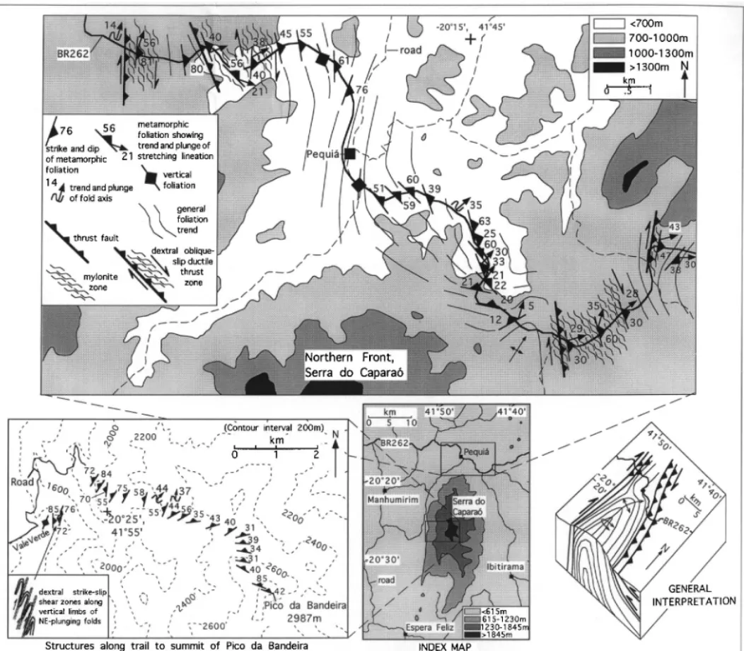
Fig. 10. Structural data collected along the northern margin and west-central zones of the Serra do Caparao´ massif. Range consists of a NNE-plunging W-vergent antiform between two major N–S-trending Brasiliano dextral shear zones.
quartzite and black biotite–quartz schist, which intruded by undated granitic stocks some of which are foliated.
locally contains garnet and sillimanite.
Between the eastern border of the Araceˆ massif
and a locality 8 km west of Domingos Martins 4.4.4. Domingos Martins–Vila Velha
Lithologies between Domingos Martins and Vila (Fig. 4), bedrock consists of narrow belts of
amphibolite–granulite-grade migmatitic quartzo- Velha are dominantly amphibolite to granulite grade gneisses, migmatites, charnockitic rocks and feldspathic gneiss separated by slices of
metasedi-mentary rocks (including massive quartzite, locally kinzigites previously assigned to the Coastal Complex of Hasui and Oliveira (1984) or classified
>95% quartz and sillimanite–garnet–biotite–
Complex (Bayer, 1987; Machado Filho et al., We describe the structural geology of this domain from W to E as shown on Figs. 4 and 5.
1983).
Eight kilometers west of Domingos Martins the
transect crosses a 3 km-wide interval of felsic- 4.5.1. Manhuac¸u–Guac¸uı´ Fault
Immediately E of Manhuac¸u, metasedimentary intermediate orthogneiss and then a 25 km-wide
belt of massive graphite–cordierite–silliman- rocks are intensely deformed into tight to isoclinal W-vergent folds on a centimeter to kilometer scale ite–garnet–biotite gneiss [previously mapped as
kinzigites by Signorelli (1993)] whose eastern ( Fig. 5). The folds generally plunge NE and locally are tubular and west-closing. These rocks are border lies at Viana (Figs. 3 and 4). This gneiss
belt is variably migmatized and widely cut by overlain in the E by a massive orthopyroxene–bio-tite gneiss with approximately homoclinal easterly pegmatites. Fe´boli (1993) obtained a Rb–Sr
refer-ence isochron of 660 Ma and a K–Ar cooling age dipping foliation attitudes. Because of the intense W-vergent deformation of the underlying metased-of 458±13 Ma on biotite extracted from the gneiss.
Between Viana and the Atlantic coast at Vila imentary rocks, the overlying gneiss is interpreted to have been thrust over them from the E although Velha, Mesozoic and Cenozoic sedimentary units
cover most Precambrian bedrock. Where basement the thrust fault is not exposed. East of this gneissic block, a belt of quartzite-dominated metasedimen-outcrop is exposed, it consists of felsic-intermediate
augen gneiss, enderbite, garnet–biotite migmatite, tary rocks occurs which is internally deformed into W and SW-vergent upright to slightly overturned and undeformed granite or granodiorite plutons
(Figs. 3 and 4). Regional mapping suggests that open to tight folds. Small E-dipping brittle-ductile thrusts were observed cutting outcrop-scale fold the gneisses in this interval are part of a
NNE-trending belt of granulite-grade basement which hinges possibly suggesting that larger displacement thrust faults cut the sequence, although they were parallels the coast. So¨llner et al. (1987, 1991) dated
zircons from biotite gneiss within this belt at a not observed. The quartzites are bordered on the E by a biotite–garnet gneiss which contains a well locality 35 km to the south of our transect and
obtained a U–Pb age of 558±2 Ma. Machado developed homoclinal E-dipping foliation near its western contact but which further eastwards is et al. (1996) report a younger metamorphic event
at 535–520 Ma ( U–Pb on zircon, monazite and internally deformed into complex folds verging both E and W.
titanite) along the coastal belt 300 km to the south.
Approximately 4–6 km W of Pequia´ on BR262 at the northwest end of the Serra do Caparao´ range (Figs. 3 and 10) several major kilometer-4.5. Structural geology
thick ductile thrust zones are exposed which con-tain highly sheared and schistose quartz–mica–gar-Between Manhuac¸u and the coast, the structural
geology is complex, however, a few generalizations net tectonites. Sense of shear is dominantly top to the WSW dextral reverse motion based on asym-can be made; there is one dominant metamorphic
foliation which generally dips eastwards and is of metric fabric geometries and asymmetric tails on garnets. Previous structural investigations of the Brasiliano age, folds of the main foliation have
axes which generally plunge NNE and structural Serra do Caparao´ have suggested that it is a large (20 km wide) W-vergent, nearly isoclinal antifor-vergence as indicated by thrust zones and fold
overturning is towards the west (Figs. 5 and 6). mal structure (Lammerer, 1987; Bayer, 1987). Foliation trends measured along a transect made As in the western and central domains, major
faults and shear zones generally dip eastwards to the highest summit of the range from the W are consistent with this interpretation of the first-order (Figs. 5 and 6). Sillimanite fiber lineations within
ductile shear zones suggests that high-grade meta- structure (Fig. 10). The western limb of the anti-form is steep to locally overturned in Val Verde
morphism accompanied deformation. Several
267 D. Cunningham et al./Precambrian Research 92 (1998) 251–275
of parasitic folds indicate that dextral strike-slip limit the interpretation for the western half of the belt but generally shallower dips of foliation and shearing has also occurred (Fig. 10). These shear
zones are along-strike with the dextral trans- relict bedding there suggest more open folding or thrust repetition. This metasedimentary belt is pressive belt W of Pequia´ on BR262 suggesting
that the transpressive belt continues along the bordered on the E by a massive 10-km-wide block of migmatite and orthogneiss. The boundary western margin of the range and forms the western
structural boundary to the Serra do Caparao´ between the two assemblages is a 4-m-wide NNE-striking, steeply W-dipping, W-side up reverse massif ( Figs. 3 and 10).
The NNE-plunging nose of the Serra do fault. The migmatites immediately E of the fault
are ubiquitously deformed into small-scale upright Caparao´ antiform is exposed SE of Pequia´ and
consists of undulating foliation with 100 m and isoclinal folds with N–S-trending axes and steep E-dipping axial planes. They are intruded by a smaller-scale NE-plunging antiforms and synforms
in the hinge zone. Immediately E of the hinge zone foliated granitoid and bordered to the E by a belt of massive intermediate orthogneiss which has very (Fig. 10) is a 6 km-wide zone of east-dipping
mylonitic and ultramylonitic metasedimentary consistent NNW striking, ENE-dipping foliation over a 4 km width. The orthogneiss appears to rocks which record thrusting and dextral oblique
thrusting to the WSW. This is one of the widest form a rigid block lacking internal folding and major shear zones. Between this block and the and most highly tectonized shear zones in the
region and records extreme attenuation of the Guac¸uı´ Fault (Fig. 5) gentle, kilometer-scale upright folds deform massive banded gneisses. The metasedimentary rocks beneath orthogneiss which
is thrust over the top of it from the E. Strongly folds generally plunge shallowly NE or NW. The Guac¸uı´ Fault is prominent on satellite imag-developed quartz and sillimanite fiber elongation
lineations indicate WSW transport directions ery and is one of the longest structures which crosses the transect. It consists of a 1 km-wide whereas, sigmoidal fabrics, asymmetric tails on
garnets and fold asymmetries all indicate thrusting ductile shear zone which can be traced for at least 200 km along strike (Bayer, 1987; Lammerer, and dextral thrusting shear sense. The major shear
zones which bound the Serra do Caparao´ and its 1987). Dragged foliation trajectories, sigmoidal fabrics, asymmetric porphyroclasts and quartzc -internal antiformal structure suggest an overall
regional-scale dextral restraining bend geometry axis fabrics indicate dextral strike-slip displace-ments (Bayer, 1987). The amount of displacement with folding either preceding or accompanying
wrenching and overthrusting. is unknown. Where the fault crosses BR262 it is
represented by a ductiley sheared granitoid which From the dextral transpressive belt along the
eastern side of the Serra do Caparao´ until the is variably mylonitic with a well developed quartz stretching lineation. The shear zone strikes 346/54 town of Ibatiba the dominant structures are
W-vergent thrust faults and overturned W-vergent NE and the lineation plunges 19/010. S–C fabrics indicate dextral shear sense.
folds cut by small undeformed to weakly deformed acid plutons. In general, within this zone,
ortho-gneisses contain homoclinal to gently folded folia- 4.5.2. Guac¸uı´ Fault–Domingos Martins
East of the Guac¸uı´ Fault an undeformed to tion attitudes whereas metasedimentary rocks
between the orthogneiss blocks are intensely folded weakly foliated granitoid crops out for ca 5 km and then a wide (8–10 km) belt of sheared quartz– into tight to isoclinal W-vergent folds. Individual
thrust faults which were identified in this zone biotite orthogneiss is encountered until the town of Venda Nova (Fig. 4). The western part of the provided top-to-the W or SW shear sense.
The town of Ibatiba is within a 10 km-wide belt orthogneiss is characterized by numerous top-to-the WSW meter-scale, NNW-striking, moderately of folded metasedimentary rocks ( Figs. 4 and 5).
The eastern half of the belt is intensely folded into to steeply ENE-dipping reverse shear zones ( VN 24 area, Fig. 6) which cut through the dominant closed to isoclinal WNW-vergent folds with
is folded into W-vergent folds. The shear zones internally folded and ductiley sheared. Westerly vergence is indicated throughout this zone by fold are filled with pegmatitic or granitic material and
generally appear to have individually accommo- asymmetries and sense of fold overturning within shear zones, sigmoidal shear fabrics and asymmet-dated tens of centimeters or less offset. However,
locally they are pervasive and cut through every ric boudinage. Sheath folds and attenuated limbs on isoclinal folds suggest high strains. The square meter of outcrop surface and thusen masse
have accommodated displacements estimated to sequence is interpreted to be overthrust by ortho-gneisses from the east because of the presence of be on the order of hundreds of meters or more.
The eastern part of this orthogneiss belt is charac- strongly overturned isoclinal folds in the eastern-most metasedimentary rocks. However, the contact terized by N-striking, steep to vertical foliation
and moderately N-plunging stretching lineations. is not exposed. Minor asymmetric W-vergent folds and
small-scale, brittle-ductile and brittle thrust faults deform 4.5.3. Domingos Martins–Vila Velha
The transect segment between the easternmost the main foliation. These minor structures coupled
with oblique-slip biotite lineations which plunge quartzite belt 8 km west of Domingos Martins and the town of Viana (Figs. 4 and 5) is characterized moderately NNE suggest dextral E-side up
trans-pressive deformation. by long-wavelength (kilometer-scale) SW-vergent
closed to isoclinal, inclined to overturned folds of
East of Venda Nova, felsic–intermediate
orthogneiss crops out for 5 km and contains the principal metamorphic foliation. Upright east-dipping limbs on the major folds are generally weakly to strongly developed east-dipping
folia-tion. In one zone several kilometer E of Venda homoclinal whereas the shorter overturned limbs are strongly buckled by parasitic folds whose asym-Nova, numerous W-vergent asymmetric
tight-to-isoclinal folds of the foliation within ductile shear metries suggest westward overturning. The town of Domingos Martins is located near the crest of zones indicate top-to-the-W thrusting. Further E
near the eastern end of this orthogneiss belt a regional W-vergent overturned antiformal nappe whose long eastern limb extends along the topo-(Fig. 5), a N35E-striking vertical mylonite zone
with moderately plunging NE-trending quartz graphic transition zone from the highland plateau at Domingos Martins to the coastal plain at Viana stretching lineations occurs in sheared granite.
Dextral shear sense is indicated by asymmetric ( Fig. 5). Immediately east of Domingos Martins this fold limb is characterized by pervasive sigmoidal foliation phacoids. Further E, quartzitic
metasedimentary rocks are intruded by the unde- W-vergent centimeter–meter scale isoclinal folds and sheath folds. Five to eight kilometers E of formed Araceˆ pluton. The quartzite appears to be
deformed into long wavelength open folds how- Domingos Martins the limb is characterized by densely developed, homoclinal E-dipping foliation. ever, scarce outcrops limit this interpretation.
Between the Araceˆ intrusion and the Vitor Hugo The prominent Batatal Fault (Fig. 3) passes through the town of Domingos Martins and cuts intrusion the prominent foliation in the quartzites,
biotite schists and paragneisses is folded into a through the vertically dipping W limb of the regional antiform ( Fig. 5). Attempts to study large W-vergent overturned antiform which is
overthrusted westwards above a duplexed zone of exposures of the fault around Domingos Martins were unsuccessful due to thick laterite and rain massive quartzite (Fig. 5). The antiform contains
smaller synforms and antiforms and can thus be forest cover. It has previously been mapped as a dextral transcurrent fault by Fe´boli (1993) who considered a foliation anticlinorium.
East of the Vitor Hugo pluton is a 9 km wide reported dextral sigmoidal structures along the fault zone.
zone of westerly directed thrusts and folds within
metasedimentary assemblages between rigid blocks From Viana to a point 5 km to the W, brittle and brittle-ductile E-side down normal faults are of gneissic basement (Fig. 5). Quartzites are
269 D. Cunningham et al./Precambrian Research 92 (1998) 251–275
This suggests that a change in structural vergence between the Coastal Mobile Belt and the originally linked West Congo Belt, which has easterly struc-tural vergence (Maurin, 1993), must lie E of Viana in the coastal or extended offshore continental crust of eastern Brazil or West Africa.
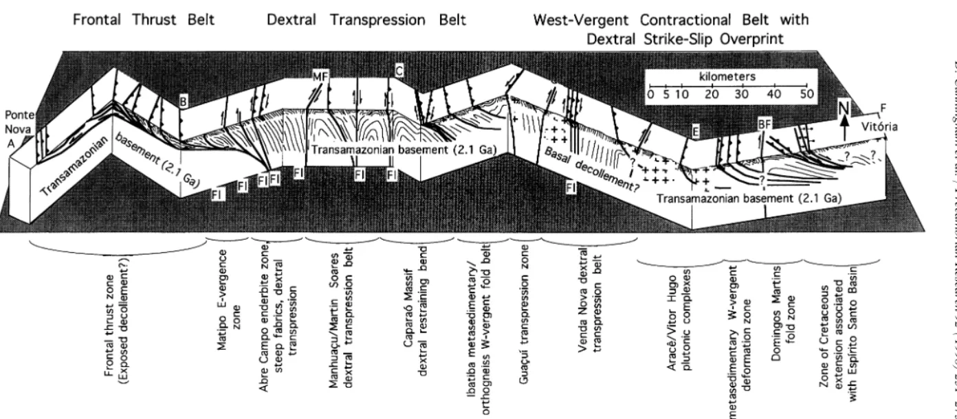
The strongly sheared shallowly dipping gneisses in the western domain ultimately root to the east and may represent a basal shear zone into which higher level thrust faults root ( Figs. 5 and 12). Together these structures converge in the zone of steep faults and shear zones in the Abre Campo region where granulitic rocks have been brought Fig. 11. Outcrop sketch of E-side-down normal fault from zone
to the surface. A large positive gravity anomaly at of brittle extension W of Viana. See Figs. 3 and 5 for location.
Numerous normal faults occur within this area and are believed Abre Campo which continues along strike for to be the westernmost expression of Cretaceous rift-related hundreds of kilometers (Haralyi et al., 1985) corre-extensional faulting along the Atlantic margin.
lates with the granulite exposures and this pro-posed structural root zone. An increase in basic compositions in basement gneisses towards this highland plateau. The fault zones dip between
50–70°E, cut the main regional foliation which is structural root zone (Herbert et al., 1991) and the presence of thick amphibolite units near Abre locally dragged into the fault zone, and internally
contain asymmetric folds and dragged wall rock Campo (Brandalise, 1991) suggests that this zone could be a cryptic suture of Transamazonian or indicating normal slip sense (Fig. 11). Of the ca
15 faults we observed, displacements are on the Brasiliano age (Fig. 12). However, the lack of ophiolitic rocks weakens this argument, and the
order of several meters or less. Abundant
E-dipping pegmatite layers also mark zones of extent to which previous continental rifting pro-gressed, and whether true oceanic crust was ever normal motion as indicated by deflected foliation
in the adjacent wall rock. generated prior to closure is unclear.
The central domain and western part of the Between Viana and the Atlantic coast, the
pau-city of outcrops hindered our structural investiga- eastern domain are dominated by steep faults and flower structure foliation geometries. There is no tions. Discontinuous migmatite and orthogneiss
exposures contain varying foliation attitudes possi- surface indication that these structures become low-angle with depth or root into a basal decolle-bly suggesting large-scale foliation folds or
differential block tilting due to normal faulting ment. Similarly, between the Serra do Caparao´ and the Atlantic coast, it is unclear if individual associated with Cretaceous development of the
continental margin. thrust faults and dextral oblique-slip faults are
regionally linked and root into a basal decollement zone. However, gravity modeling for the region suggests a low-angle detachment zone exists 5. Discussion of results and implications for
Gondwana assembly between 10 and 15 km depth between Ibatiba and
Vito´ria and at progressively shallower depths
(3–10 km) between Ibatiba and Rio Casca
Although this work is focused largely on the
structural geology of a single transect, important (Signorelli, 1993). Unpublished magnetotelluric data from the Ribeira belt 300 km to the southwest regional conclusions can be drawn from our
obser-vations and the transect data. Except for a local likewise suggest a detachment zone at 12 km depth for over 200 km across the orogen (S. Fontes, pers. zone of backfolding near Matipo (Fig. 5) the entire
D.
Cunningham
et
al.
/
Precambrian
Research
92
(
1998
)
251
–
275
271 D. Cunningham et al./Precambrian Research 92 (1998) 251–275
the central and eastern domains root into a low- The second and dominant deformational event recorded within the Coastal Mobile Belt is the angle zone at depth. There appears to be a
funda-mental partitioning between frontal thrust kine- Brasiliano transpressional event. It is characterized by west-directed thrusting W of Abre Campo,
matics in the western domain and dextral
transpression and strike-slip kinematics in the dextral transpression and contraction between Abre Campo and the coast, and late-stage NNE-middle core region of the orogen where orogen
parallel movements were accomodated ( Vauchez trending dextral transcurrent faulting. Like modern-day transpressive orogens it probably was and Nicolas, 1991). On a local scale, many block
boundaries are marked by highly deformed met- a protracted event with separate deformational phases. However, fabrics formed during peak asedimentary belts suggesting that these units have
lower mechanical strength and acted as the domi- metamorphic conditions have generally obliterated or transposed earlier features. The conspicuous nant glide horizons for W-directed overthrusting.
Large dextral transcurrent faults like the Guac¸uı´ absence of elongate quartz lineations throughout most of the region in quartz-rich tectonites may and Batatal faults appear to cut through all older
contractional structures and thus are interpreted be due to static quartz recrystallization associated with elevated crustal temperatures during emplace-to be late-post Brasiliano in age.
Three major structural events are interpreted to ment of syn-post-tectonic intrusions. Alternatively, Brasiliano contractional/transpressive deformation have affected the region. The first event is
repre-sented by relict zones of folded gneissic banding, may not have persisted during sub-amphibolite facies cooling when basal slip in quartz instead of intrafolial folds and discontinuous banding in
massive charnockitic and migmatitic gneisses. rhombohedral slip would have taken over as the dominant slip mechanism (Goodge et al., 1993). These fabrics may have formed during the
Transamazonian event or during progressive So¨llner et al. (1991) and Machado et al. (1996) citing zircon, monazite and titanite U–Pb ages Brasiliano deformation. Rocks throughout the
transect are penetratively overprinted by suggest that the timing of maximum levels of
Brasiliano metamorphism and deformation is Brasiliano amphibolite–granulite-grade
metamor-phism and deformation. However, zircon geochro- younger to the E from 622±7 Ma in the Sa˜o
Francisco craton to 590–565 Ma in the Serra do nology indicates that many basement gneisses have
a Transamazonian origin and some contain Caparao´ region to 560–520 Ma along the Espı´rito Santo coast. The dextral component of deforma-Archean zircons possibly derived detritally from
the Sa˜o Francisco craton ( Teixeira et al., 1987; tion suggests non-orthogonal collision between the Congo and Sa˜o Francisco cratons or that the So¨llner et al., 1987, 1991; Machado et al., 1996).
Basement gneisses within the West Congo Belt in curved southeastern margin of the Sa˜o Francisco Craton (Fig. 1) modified the deformation field as the Ogooue´ region of Gabon/Congo which were
formerly connected to eastern Brazil have also previously suggested further south in the Ribeira Belt by Vauchez et al. (1994).
been dated as Transamazonian [equivalent to the
Eburnian; Cahen et al. (1984) and Bertrand and Cambrian syn- to post-tectonic intrusions such as the Araceˆ granite may be spatially related to Jardim de Sa´ (1990)]. Previous work on the Sa˜o
Francisco craton [e.g. Marshak and Alkmim the large late-stage transcurrent faults such as the Guac¸uı´ Fault and were perhaps emplaced during (1989)] suggests that the relics of a
northwest-verging Transamazonian fold-thrust belt crosses a period of localized dextral transtension (So¨llner et al., 1987). Cunningham et al. (1996) report the southern end of the Sa˜o Francisco craton, to
the west of the region of the transect discussed structural evidence for post-Brasiliano orogenic collapse from 150 km to the north. Thus the here. Thus, we suggest that the Coastal Mobile
Belt at the latitude of Vitoria and Ponte Nova possibility exists that similar zones of localized transtension/extension occur within the area inves-contains relics of the roots of a Transamazonian
orogen, cross-cut and obscured by later Brasiliano tigated here but were not observed due to incom-plete outcrop exposure.
D.
Cunningham
et
al.
/
Precambrian
Research
92
(
1998
)
251
–
275
273 D. Cunningham et al./Precambrian Research 92 (1998) 251–275
The final major event to have affected the region and uplift of the West Congo Belt occurs between ca 0.8 and 0.6 Ga prior to closure of the Coastal is the Early–mid-Cretaceous continental rifting
which led to the opening of the South Atlantic. Mobile Belt (Porada, 1989). Contractional and dextral transpressive closure of the western This event is manifested by numerous E-dipping
brittle normal faults at the extreme eastern end of (Brazilian) side of the rift basins follows during stage 5 between ca 0.6 and 0.5 Ga. East-directed the transect. These faults are believed to mark the
western fringe of the normal faulted terrain which subduction during closure of the ocean may have led to the development of a short-lived magmatic comprises the Espı´rito Santo continental margin.
Associated with Cretaceous rifting is the elevation arc in Espı´rito Santo ( Wiedemann, 1993; Campos Neto and Figueiredo, 1995). Previous of the Brazilian continental margin and subsequent
erosion exposing deeper levels of the metamorphic Transamazonian structures are overprinted, amphibolite–granulite-grade metamorphic condi-basement. Ultimate separation of the two
conti-nents appears to have occurred along the former tions are reached and syn-post-tectonic intrusions invade Espı´rito Santo possibly localized by late-vergence boundary between the W-vergent Coastal
Mobile Belt in Brazil and the E-vergent West stage dextral strike-slip and transtensional transcurrent faulting. Quartzite-dominated plat-Congo Orogen in West Africa perhaps by
reactiva-tion of weak Brasiliano fault zones. Interestingly, form facies sediments are intensely deformed between massive basement blocks during rift inver-W of our transect, a separate array of Cretaceous–
Tertiary E-side-down normal faults are visible on sion. In stage 6, early–mid Cretaceous rifting leads to rift shoulder uplift, subsequent erosion and satellite imagery directly W of Ponte Nova and
have been mapped further north along strike by exhumation of mid–lower-crustal rocks and sepa-ration of the West Congo Belt from the Coastal Saadi (1991). These faults appear to be responsible
for the development of the Rio Doce Basin in the Mobile Belt as the South Atlantic opens. Ponte Nova area (Fig. 1).
Based on these considerations, an evolutionary
model divided into six stages is proposed to explain Acknowledgment the tectonic evolution of the Coastal Mobile Belt
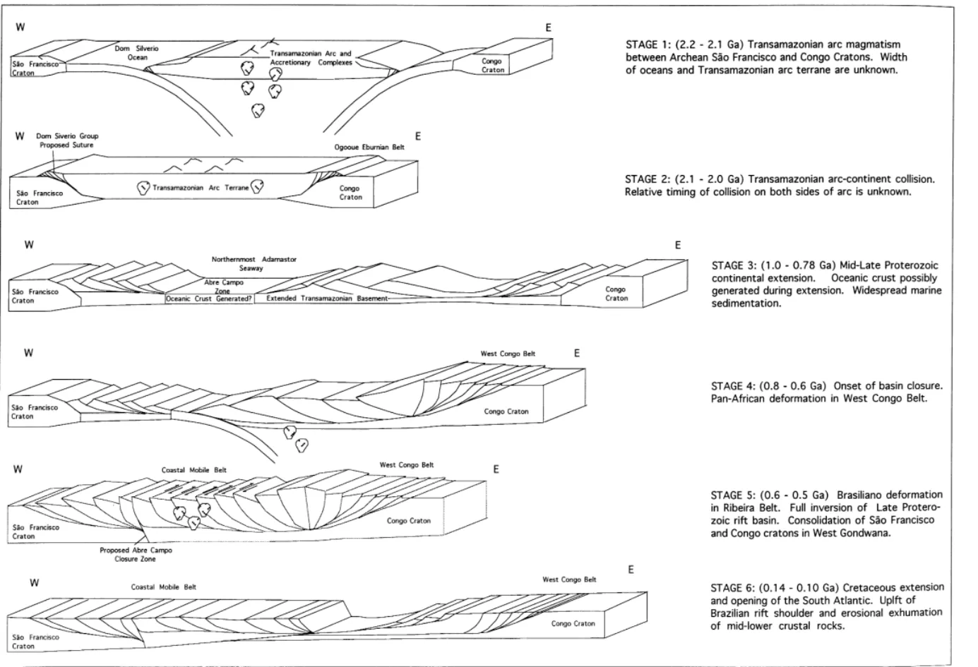
from the Early Proterozoic to the present (Fig. 13). The authors are grateful to Hanna Jordt-In stage 1, the Archean Sa˜o Francisco and Congo Evangelista for her careful advice and criticism of cratons are separated by an ocean of unknown the manuscript. Helpful reviews by N. Machado, width. An active island arc with adjoining subduc- R. Strachan and R. Bauer led to improvement of tion complex of Transamazonian age forms at ca the manuscript. D.C. is especially grateful to Andre´ 2.2–2.1 Ga and in stage 2 collides with both cra- Danderfer for his friendship, useful scientific dis-tons as the ocean closes (ca 2.1–2.0 Ga). The cussions and logistical help. This work was
relative timing of collision between the arc and supported by NSF International Programs
two cratons is unknown. The Dom Silve´rio Group Grant No. 9301292 awarded to Cunningham and W of Ponte Nova possibly marks the suture zone Marshak.
in Brazil [see discussion in Cunningham et al. (1996)]. In stage 3, the Transamazonian collisional
belt collapses and extends during the mid–late References Proterozoic (ca 1.0–0.78 Ga) into a wide zone of
ensialic rifting. Rifting may have progressed to the Almeida, F.F.M., 1977. O Craton do Sa˜o Francisco. Rev. Bras. Geol. 7, 349–364.
point where oceanic crust was generated
(Pedrosa-Almeida, F.F.M., Hasui, Y., 1984. O Precambriano do Brasil, Soares et al., 1992). Platform quartzites and other
Edgard Blu¨cher, Sa˜o Paulo. rift-related sedimentary rocks are widely deposited
Bayer, P., 1987. Strukturgeologische Untersuchungen im brasil-in the ensialic sea which represents the northern- ianischen Ku¨sten Mobile Belt, su¨dliches Espı´rito Santo, unter most seaway of the Adamastor Ocean (Hartnady besonder Beru¨cksichtigung der Brasiliano Intrusionen.
Bayer, P., Horn, H.A., Lammerer, B., Schmidt-Thome, R., geolo´gica. In: Contribuic¸o˜es a Geologia e a Petrologia. Belo Weber-Diefenbach, K., Wiedemann, C., 1986. The Brasiliano Horizonte, SBG/CBMM, pp. 71–93. Boletim Especial SBG-mobile belt in southern Espı´rito Santo (Brazil ) and its igne- Nu´cleo de Minas Gerais.
ous intrusions. Zbl. Geol. Pala¨ont. Teil I H. 910, 1429–1439. Hartnady, C.J.H., Joubert, P., Stowe, C.W., 1985. Proterozoic Bernasconi, A., 1987. The major Precambrian terranes of east- crustal evolution in southwestern Africa. Episodes 8,
ern South America: a study of their regional and chrono- 236–244.
logical evolution. Precambrian Res. 37, 107–124. Hasui, Y., Oliveira, M.A.F., 1984. Provincia Mantiqueira, Setor Bertrand, J.M., Jardim de Sa´, E.F.,1990. Where are the Central, in: Almeida, F.F.M., Hasui, Y. ( Eds), O Eburnian–Transamazonian collisional belts? Can. J. Earth Precambriano do Brasil. Edtora Blu¨cher, Sao Paulo,
Sci. 27, 1382–1393. pp. 308–344.
Brandalise, L.A., 1991, Programa Levantamentos Geolo´gicas Herbert, H.J., Mu¨ller, G., Roeser, H., Schulz-Kuhnt, D., Bc¸sicos do Brasil, Ponte Nova. SF.23-X-B-II. Estado de Tobschall, H.J., 1991. Comparison of geochemical data from Minas Gerais, Belo Horizonte, DNPM/CPRM. gneiss–migmatite and granulite facies terrains, eastern Minas Brito Neves, B.B., Cordani, U.G., 1991. Tectonic evolution of Gerais, Brazil. Chem. Erde 51, 187–200.
south America during the Late Proterozoic. Precambrian Jordt-Evangelista, H., 1992. O Grupo Dom Silve´rio a SE de Res. 53, 23–40. Minas Gerais: petrografia, metamorfismo e geologia econoˆm-Cahen, L., Snelling, N.J., Delhal, J., Vail, J.P., 1984. The ica. Rev. Escola de Minas, Ouro Preto 45 (1/2), 140–142.
Geochronology and Evolution of Africa. Clarendon Press, Jordt-Evangelista, H., Mu¨ller, G., 1986. Petrology of a trans-Oxford. ition zone between the Archean craton and the coast belt SE Campos Neto, M.C., Figueiredo, M.C.H., 1995. The Rio Doce of the Iron Quadrangle, Brazil. Chem. Erde 46, 145–160.
Orogeny, Southeastern Brazil. J. South Am. Earth Sci. 8 Lammerer, B., 1987. Short notes on a structural section through (2), 143–162. the Ribeira mobile belt (Minas Gerais and Espı´rito Santo Cordani, U.G., Delhal, J., Ledent, B., 1973. Orogeneses
super-Brazil ). Zbl. Geol Pala¨ont. Teil I H 78, 719–728.
pose´es dans le pre´cambrien du Bresil sud-oriental ( Etats de Leonardos, O.H., Fyfe, W.S., 1974. Ultrametamorphism and Rio De Janeiro et de Minas Gerais). Rev. Brasil. Geocienc.
melting of a continental margin: the Rio de Janeiro region, 3, 1–22.
Brazil. Contrib. Mineral Petrol. 46, 201–214.
Cordani, U.G., Kawashita, K., Mu¨ller, G., Quade, H., Reimer, Machado Filho, L., Ribeiro, M.W., Gonzales, R.S., Schemin, V., Roeser, H., 1980. Interpretac¸a˜o tectoˆnica e petrolo´gica
C.A., Santos Neto, A., Palmeira, R.C.B., Pires, J.L., Teixeira, de dados geocronolo´gicos do embasamento no bordo sudeste
W., Castor, H.H.F., 1983. Projeto Radambrasil, Geologia do Quadrilc¸tero Ferrı´fero/MG. An. Acad. Bras. Cienc. 52,
das folhas SF-23 Rio de Janeiro and SF-24 Vitoria. Lev. Re. 785–799.
Nat. 32, Dep. Nac. Prod. Min., Rio de Janeiro. Cunningham, W.D., Marshak, S., Alkmim, F.F., 1996.
Machado, N., Valladares, C., Heilbron, M., Valeriano, C., 1996. Structural style of basin inversion at mid-crustal levels: two
U–Pb geochronology of the central Coastal Mobile Belt transects in the internal zone of the Brasiliano Arac¸uai Belt,
(Brazil ) and implications for the evolution of the Brazilian Minas Gerais, Brazil. Precambrian Res. 77, 1–15.
Orogeny. Precambrian Res. 79, 347–361. Ebert, H., 1968. Ocorreˆncias de facies granulı´ticas no sul de
Mascarenhas, J.F., 1979. Evoluc¸a˜o geotectonica do Minas Gerais e em areas adjacentes, em dependeˆncias de
Precambriano do oeste da Bahia. In: Inda, H.V.A. (Ed.), estrutura orogeˆnica; hipo´tese sobre sua origem. An. Acad.
Geologia e recursos Minerais do estado da Bahia. SME-BA, Bras. Cieˆnc. Rio de Janeiro 40, 215–229.
Textos Basicos, vol. 2, pp. 25–53. Fe´boli, W.L., 1993. Programa Levantamentos Geolo´gicas
Marshak, S., Alkmim, F.F., 1989. Proterozoic contraction/
Ba´sicos do Brasil, Afonso Cla´udio. SF.24-V-A-III. Estado
extension tectonics of the southern Sa˜o Francisco region, do Espı´rito Santo, Brasilia, DNPM/CPRM.
Minas Gerais, Brazil. Tectonics 8, 555–571. Fonseca, M.J.G., 1979. Carta geolo´gica do Brasil ao
milione´s-Maurin, J.C., 1993. La chaine panafricaine ouest-congolienne: imo; folhas Rio de Janeiro (SF.23), Vito´ria (SF.24), e Iguape´
corre´lation avec le domaine est-bre´silien et hypothe´se ge´ody-(SG.23). Brası´lia, DNPM.
namique. Bull. Soc. Geol. France 164 (1), 51–60. Goodge, J.W., Hansen, V.L., Peacock, S.M., Smith, B.K.,
Mu¨ller, H.J., Roeser, H., Schulz-Kuhnt, D., Tobschall, H.J., Walker, N.W., Kinematic evolution of the Miller Range
1991. Comparison of geochemical data from gneiss–migmat-Shear Zone, central Transantarctic mountains, Antarctica,
ite and granulite facies terrains, eastern Minas Gerais, Brazil. and implications for Neoproterozoic to Early Paleozoic
tec-Chem. Erde 51, 187–200. tonics of the east Antarctic margin of Gondwana. 1993.
Pedrosa-Soares, A.C., Noce, C.M., Vidal, P., Monteiro, Tectonics 12 (6), 1460–1478.
R.L.B.P., Leonardos, O.H., 1992. Toward a new tectonic Haralyi, N.L.E., Hasui, Y., 1982. The gravimetric information
model for the Late Proterozoic Arac¸uaı´ (SE Brazil )–West and the Archean–Proterozoic structural framework of eastern
Congolian (SW Africa) Belt. J. South Am. Earth Sci. 6, Brazil. In: ISAP, Salvador, R. Brasileira Geocieˆncias, Sa˜o
33–47. Paulo, vol. 12, Nos. 1–3, pp. 160–166.
Porada, H., 1979. The Damara–Ribeira orogen of the pan-Haralyi et al., 1985. Ensaio sobre a estruturac¸a˜o crustal do
275 D. Cunningham et al./Precambrian Research 92 (1998) 251–275
Brazil as interpreted in terms of continental collision. So¨llner, F., Lammerer, B., Weber-Diefenbach, K., 1989. Tectonophysics 57, 237–265. Brasiliano age of a charnoenderbitic rock suite in the Porada, H., 1989. Pan-African rifting and orogenesis in south- Complexo Costeiro (Ribeira Mobile Belt), Espı´rito ern to equatorial Africa and Eastern Brazil. Precambrian Res. Santo/Brazil: evidence from U–Pb geochronology on zircons.
44, 103–136. Zbl. Pala¨ont. Teil. I H 56, 933–945.
Saadi, A., 1991. Ensaio sobre a morfotectoˆnica de Minas So¨llner, F., Lammerer, B., Weber-Diefenbach, K., 1991. Die Gerais. ( Tenso˜es Intra-Placa, Descontinuidades Crustais e Krustenentwicklung in Der Ku¨stenregion No¨rdlich von Rio Morfogeˆnese). Tese de Livre Doceˆncia, Instituto de De Janeiro/Brasilien. Mu¨nchner Geol. Hefte 4, 100 Geocieˆncias, UFMG, Belo Horizonte. Teixeira, W., 1982. Geochronology of the southern part of the Schermerhorn, L.G., 1981. The West Congo orogen: a key to Sa˜o Francisco craton. Rev. Bras. Geocienc. 12, 268–277.
Pan-African thermotectonism. Geol. Rundsch. 70, 850–867. Teixeira, W., Jordt-Evanglista, H., Kawashita, Taylor, P.N., Schulz-Kuhnt, D., Mu¨ller, G., Hoefs, J., 1990. Petrology of 1987. Complexo granulı´tico de Acaiaca, MG: idade. petro-high-grade metamorphic terrains in the Abre Campo-Jequeri geˆnese e implicac¸o˜es tectoˆnicas. In: Anais do 4th Simpo´sio Quadrangle, eastern Minas Gerais Brazil. Chem. Erde 50, de Geologia de Minas Gerais, Belo Horizonte.
225–245. Torquato, J.R., Cordani, U.G., 1981. Brazil–Africa geological Signorelli, N., 1993. Programa Levantamentos Geolo´gicas
links. Earth Sci. Rev. 17, 155–176. Bc¸sicos do Brasil, Afonso Clc¸udio. SF. 24-V-A-II. Estado de
Trompette, R., 1997. Neoproterozoic (~600 Ma) aggregation Espı´rito Santo e Minas Gerais, Brasilia, DNPM/CPRM.
of Western Gondwana: a tentative scenario. Precambrian da Silva, J.M.R., de Lima, M.I.C., Veronese, V.F., Ribeiro R.N.
Res. 82, 101–112. Jr, Rocha, R.M., Siga O. Jr, 1987. Levantamento de Recursos
Vauchez, A., Nicolas, A., 1991. Mountain building: strike-par-Naturais, vol. 34, Folha SE.24 Rio Doce. IBGE, Rio de
allel motion and mantle anisotropy. Tectonophysics 185, Janeiro.
183–201. Sluitner, Z., Weber-Diefenbach, K., 1989. Geochemistry of
Vauchez, A., Tomassi, A., Egydio-Silva, M., 1994. Self-indenta-charnoenderbitic granulites and associated amphibolitic
tion of a heterogeneous continental lithosphere. Geology gneisses in the coastal region of Espı´rito Santo, Brazil. Zbl.
22, 967–970. Geol. Pala¨ont. Teil I 917–931.
Wiedemann, C.M., 1993. The evolution of the Early Paleozoic, So¨llner, F., Lammerer, B., Weber-Diefenbach, K., Hansen,
late- to post-collisional magmatic arc of the Coastal Mobile B.T., 1987. The Brasiliano orogenesis: Age determinations
Belt, in the state of Espı´rito Santo, eastern Brazil. An. Acad. (Rb–Sr) in the coastal mountain region of Espı´rito Santo,
