NEUTRON PROBE MEASUREMENT OF SOIL WATER
CONTENT CLOSE TO SOIL SURFACE
M.C. FALLEIROS
1Universidade Estadual de Londrina, C.P. 6001, CEP: 86051-970 - Londrina,PR.
A. RAVELO SÁNCHEZ
2Istituto de Investigaciones Fundamentales en Agricultura Tropical, Havana-Cuba.
M.DORNELAS de SOUZA
EMBRAPA/Centro de Pesquisa Agro-Florestal, C.P. 133, CEP: 69301-970 - Boa Vista,RR. O.O.S. BACCHI3; J.E. PILOTTO; K. REICHARDT3
Centro de Energia Nuclear na Agricultura/USP, C.P. 96, CEP: 13400-970 - Piracicaba,SP.
ABSTRACT: The problem of neutron probe soil water content measurements close to soil surface is analysed from the spatial variability and also from the slow neutron "loss" to the atmosphere points of view. Results obtained on a dark red latosol of the county of Piracicaba,SP, indicate the possibility of precisely measuring the neutron "sphere of influence" when different media are used on soil surface.
Key Words: neutron probe, soil water content, spatial variability.
MEDIDA DE UMIDADE DO SOLO COM SONDA DE NÊUTRONS
NAS PROXIMIDADES DA SUPERFÍCIE
RESUMO: O problema da medida da umidade nas proximidades da superfície do solo é abordado do ponto de vista de sua variabitidade espacial e da "perda" de nêutrons lentos para a atmosfera. Dados, obtidos em terra roxa estruturada do município de Piracicaba,SP, mostram a possibilidade de se avaliar, com precisão, a "esfera de influência" da medida, quando se utilizam meios diferentes na superfície do solo.
Descritores: sonda de nêutrons, umidade do solo, variabilidade espacial.
INTRODUCTION
The principle of soil water content measurement with neutron probes involves the establishment of a slow neutron "cloud" in the soil around the probe, which defines its "sphere of influence". For measurements close to soil surface, part of the sphere is in the atmosphere, causing a loss of slow neutrons and consequently incorrect measurements. It is therefore of great importance to know the radius of the sphere to define how close to soil surface measurements can be taken without neutron loss. Several authors, e.g. HAVERCAMP et al. (1984), MENDES et al. (1992) and TURATTI & REICHARDT (1991) avoid surface measurements and assume surface water content as being equal to the first
measurement made in depth. KIRDA & REICHARDT (1992) compare neutron probe measurements with other non-nuclear methodologies, but avoid discussing surface measurements with depth probes. GREACEN (1981) describes extensively the assessment of soil water content by the neutron method, and for the case of surface measurements, suggests the elaboration of special calibration curves or the use of specially designed surface equipment. This study contributes to the understanding of neutron probe measurements close to soil surface, suggesting a new approach to define how close to soil surface safe water content measurements can be made and also quantifying the spatial variability of these measurements, for a given soil type.
1 Bolsista da CAPES 2
Bolsista da AIEA
MATERIAL AND METHODS
1. SOIL: a dark red latosol, known as "terra roxa estruturada", with 64.0; 7.5 and 28.5% of clay, silt and sand, respectively;
2. NEUTRON PROBE: manufactured by Nardeux, France, model SOLO 25, with Am-Be 1,48 GBeq source.
3. EXPERIMENTAL DESIGN: two plots of 7 x 7 m, two meters apart, each with 9 aluminum access tubes, as shown in Figure 1. These access tubes were used to make neutron probe readings from above soil surface down to the 50 cm depth. Measurements were performed with the upper part of the access tube in air, in plastic (using a factory designed "deflector") and in water (using a pool avoiding water infiltration into the soil). Measurements were performed in two soil water content conditions:
i) dry condition, in the dry season, when water content reaches miminum values in the field, and
ii) wet condition, in the rainy season, when water content reaches maximum field values.
RESULTS AND DISCUSSION
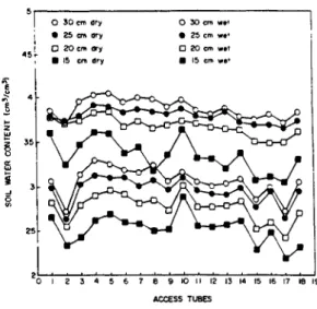
Figures 2 and 3 present soil water content data obtained from the access tubes having the upper part in air, as recommended. The figures give an idea of the variability of soil water content measurements which is quantified in TABLE 1. The tendency of an increase in C.V. from the 50 cm depth in direction to soil surface might be due to the erratic loss of neutrons to the atmosphere. It is difficult, however, to separate this effect from water content and bulk density effects, since these parameters are more variable close to soil surface.
where xa = 1,96 and a2 is the variance. The N values shown in TABLE 1 are a guide for the most common question which is the recommendation of number of access tubes needed.
In most cases, however, soil is not homogeneous and mostly in terms of water content. It is therefore not possible, in situations like Figure 4, to define the radius of the sphere. On the other hand, if a medium of high neutron moderation characteristics is placed around the access tube, above soil surface, the definition of the influence sphere becomes very evident. Figure 5 is an exam-ple using a plastic factory made neutron "deflector" or a water pool around access tube at soil surface. When part of the slow neutron sphere reaches this different medium of high moderation property, count ratios at soil surface increase rapidly in relation to measurements taken in the air.
Although the effect becomes more evident for the water pool, this procedure is very unpractical to be performed under field conditions for a large number of access tubes. The factory made deflector or any plastic or paraffin block are very handy and can be used successfully to define the shallowest depth at which safe measurements can be made using neutron probes.
REFERENCES
BACCHI, O.O.S.; REICHARDT, K. A sonda de neutrons e seu uso na pesquisa agronômica. Boletim
Didático. CENA/USP, Piracicaba, n.22, p.1-84, 1990.
GREACEN, E.L. Soil water content by the neutron
method. East Melbourne: CSIRO, 1981. 140p.
HAVERCAMP, R.; VAUCLIN, M.; VACHAUD, G. Error analysis is estimating soil water content from neutron probe measurements: 1. Local standpoint. Soil
Science, Baltimore, v.137, n.2, p.78-90, 1984.
KIRDA, C.; REICHARDT, K. Comparison of neutron moisture gauges with non-nuclear methods to mesure field soil water status. Scientia Agricola, Piracicaba, v.49, n.l, p.111-121, 1992.
MENDES, M.E.G.; VILLAGRA, M.M.; SOUZA, M.D.; BACCHI, O.O.S.; REICHARDT, K. Relações hídricas em seringal no município de Piracicaba,SP.
Scientia Agricola, Piracicaba, v.49, n.l, p.103-109, 1992.
TURATTI, A.L.; REICHARDT, K. Soil water storage variability in Terra Roxa Estruturada. Revista
Brasileira de Ciência do Solo, Campinas, v.15, n.3, p.253-257, 1991.
WARRICK, A.W.; NIELSEN, D.R. Spatial variability of soil physical properties in the field. In: HILLEL, D., ed. Applications of soil physics. New York: Academic Press, 1980. cap. 13, p.319-44.
Received in April 7, 1993 Accepted in July 1, 1993