Characterization and classification of floodplain...
423
CHARACTERIZATION AND CLASSIFICATION OF FLOODPLAIN SOILS
IN THE PORTO ALEGRE METROPOLITAN REGION, RS, BRAZIL
Caracterização e classificação de solos de várzea na região metropolitana de Porto Alegre, RS
Luís de França da Silva Neto1, Alberto Vasconcellos Inda2, Paulo César Do Nascimento2,
Elvio Giasson2, Catiline Schmitt2
, Nilton Curi3
ABSTRACT
In the Porto Alegre metropolitan region (PAMR) there are a significant proportion of floodplain soils, mainly Planosols and Gleysols, in relation to upland soils. This study aimed to evaluate the morphological, chemical and physical characteristics, and to classify floodplain soils in the PAMR. Six soil profiles were evaluated under different sedimentary lithologies and drainage classes, and samples were collected for chemical and physical analyzes. Two orders of mineral soils (Planosols and Gleysols) and one order of organic soil (Organosols) were identified. The soils were moderately deep to deep and stratified. In mineral soils hue ranged between 7.5YR and 2.5Y, with the occurrence of Bg, Btg or Cg gley horizons, while in organic soil the colors were neutral. Sand and silt were the predominant particle sizes according to the origin sedimentary deposits. The organic carbon content was negatively related to soil density and positively related to soil specific surface area and with soil cation exchange capacity. Soil chemical characterization showed expressive variation in bases, aluminum and sodium saturation. Ki index and Fe(CBD)/Fe(H2SO4) ratio
indicated a low soil weathering degree. The different sedimentary lithologies and the soil hydromorphism degree were the main factors related to differences in morphological, physical and chemical characteristics of soils in the PAMR.
Index terms: Hydromorphic soils; quaternary sediments; specific surface area.
RESUMO
Na região metropolitana de Porto Alegre (PAMR) é expressiva a proporção de solos de várzea em relação aos solos de terras altas, com predomínio de Planossolos e Gleissolos. Este estudo objetivou caracterizar a morfologia, a física e a química, e classificar taxonomicamente solos em posições de várzea na PAMR. Foram abertas seis trincheiras em relevo plano, sob diferentes litologias sedimentares e classes de drenagem,onde foram realizadas a descrição morfológica dos perfis de solos e a coleta de amostras para as análises físicas e químicas.Foram identificadas duas ordens de solos minerais (Gleissolo e Planossolo) e uma orgânica (Organossolo). Os solos foram moderadamente profundos a profundos e estratificados. Nos solos minerais a matiz variou entre 7,5YR e 2,5Y, com ocorrência de horizontes gleizados Bg, Btg ou Cg, enquanto no Organossolo as cores foram neutras. A granulometria dos solos, com predominância das frações areia e silte, variou conforme os depósitos sedimentares de origem. A expressiva amplitude dos teores de C orgânico mostrou relação negativa coma densidade do solo, e positiva com a área superficial específica e a capacidade de troca de cátions. Os atributos químicos também se mostraram discriminantes entre os solos avaliados, com ocorrência de distrofismo e eutrofismo, variações amplas dos teores de Al3+ trocável e ocorrência de caráter solódico. Nos solos minerais o índice Ki e a relação
Fe(CBD)/Fe(H2SO4) indicaram um grau incipiente de desenvolvimento dos solos. O material de origem e o grau de hidromorfismo foram
os principais fatores responsáveis pelas diferenças nas características morfológicas, físicas e químicas dos solos na PAMR.
Termos para indexação: Solos hidromórficos; sedimentos quaternários; área superficial específica.
1Empresa Brasileira de Pesquisa Agropecuária/EMBRAPA – Embrapa Solos – Rio de Janeiro – RJ – Brasil
2Universidade Federal do Rio Grande do Sul/UFRGS – Faculdade de Agronomia – Departamento de Solos – Porto Alegre – RS – Brasil
3Universidade Federal de Lavras/UFLA – Departamento de Ciência do Solo/DCS – Cx. P. 3037 – 37200-000 – Lavras – MG – Brasil – [email protected]
Received in may 20, 2015 and approved in july 6, 2015 INTRODUCTION
In general, floodplain soils are considered the soils found along the plains of rivers, lakes and lagoons, where they develop in sediments from various sources under various drainage classes often with hydromorphic conditions. In Rio Grande do Sul, the floodplain soils occupy an area of approximately 53,000 km2 (19% of the territory). This proportion changes significantly in the Porto Alegre metropolitan region (PAMR), where the floodplain soils occupy about 60% of the area. In recent decades, the
occupation of floodplain soils with agricultural activities has intensified in this region, especially for rice, corn and bean crops, as well as pastures and vegetables (Hasenack et al., 2008). On the other hand, urbanization pressure has increased recently, which can result in important changes in local environment.
soils take into account their pedogenetic peculiarities, ensuring the sustainability of agricultural activities and the conservation of natural resources.
In the PAMR there are two distinct geological features: the crystalline base and quaternary sediments (sands, silts and clays). The first consists of a set of granitic bodies with local names amid an intricate granite-gneiss complex (Schneider et al., 1974). The quaternary sedimentary deposits, of colluvial-alluvial and aeolian origin, involve Pleistocene (paleodunes, fluvial deposits and colluvial paleosols) and Holocene formations (recent alluvial sediments) (CPRM, 2006). According to Rio Grande do Sul soil reconnaissance surveys (Brazil, 1973; Radambrasil, 1986) and of the city of Porto Alegre (Schneider et al., 2008), the main soil orders occurring in the floodplain areas of the PAMR are Haplic Planosols, Haplic Gleysols and Melanic Gleysols with Fluvic Neosols and Haplic Organosols occurring in lesser proportions (Streck et al., 2008).
The significant heterogeneity of soils in floodplain areas is inherent to hydromorphic environments (Corrêa et al., 2003; Souza Júnior et al., 2007; Coringa et al., 2012; Guimarães et al., 2013), in which the topographic location and drainage capacity, water quality, sediment type and
seasonal flooding influence pedogenetic features. The objective of this study was to characterize the morphology, physical and chemical, as well as taxonomically classify floodplain soils developed in different parts of the PAMR.
MATERIAL AND METHODS Environmental characteristics
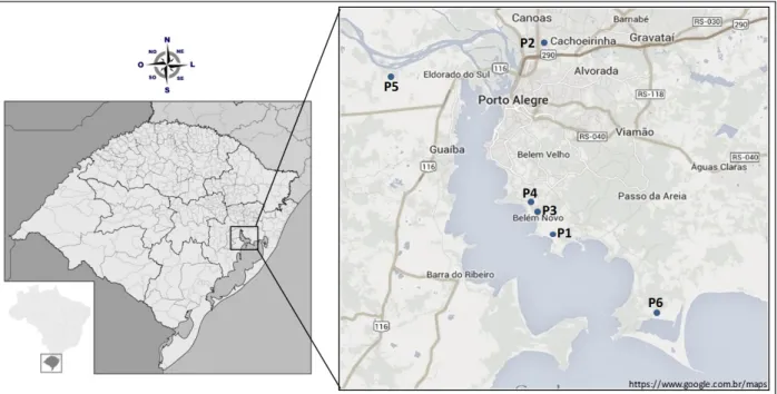
The study areas are located in the metropolitan region of Porto Alegre, between the coordinates 29º45’ and 30º15’ S (latitude) and 50º30’ and 51º30’ W (longitude), in the cities of Porto Alegre, Cachoeirinha, Eldorado do Sul and Viamão (Figure 1). The climate is humid subtropical, with an average annual temperature of 19.5 °C, the coldest month being 14 oC, and an average rainfall of 1309 mm yr-1, with a summer dry period (Maluf, 2000).
The geology consists of Quaternary sedimentary deposits from the Pleistocene and Holocene, consisting predominantly of weakly consolidated sandstone, silty-clay sediments and tuffaceous deposits (Radambrasil, 1986; CPRM, 2006). The vegetation has the influence of alluvial forests and floodplain forests (semideciduous forest phytoecological region); and of wetland areas, with lagoon and alluvial influence (Pioneer Formations phytoecological region).
Description of soil profiles, collection and sample preparation
For the study, six trenches were dug at different points of the PAMR (Figure 1, Table 1) on flat relief positions (0-2% slope), with soil drainage classes ranging from moderate to imperfectly drained and poorly drained. In the trenches, morphological descriptions of soil profiles and the collection of disturbed and undisturbed soil samples were conducted according to Santos et al. (2005). The disturbed soil samples were air dried, and passed through 2 mm mesh sieve to obtain fine air-dried soil fraction (FADS). The total clay (Ø < 0.002 mm) was collected after sedimentation of the soil dispersion with 1 mol L-1 NaOH flocculated with a 0.1 mol L-1 HCl washed with a ethanol/ water solution at a 1:1 ratio, oven-dried at 60 °C and ground. Physical analyses
Physical testing included granulometric composition of the soil by the pipette method using NaOH 1 mol L-1 as the chemical dispersant; natural clay, the bulk density (BD) by the volumetric ring method, the particle density (PD) in a volumetric flask (Empresa Brasileira de Pesquisa Agropecuária - Embrapa, 1997), calculating the degree of flocculation (FD). The specific surface area (SSA) of the clay fraction was estimated by the water adsorption method at 20% relative moisture (Quirk, 1955).
Chemical analysis
The chemical analyzes included pH in water and KCl; Ca2+, Mg2+ and Al3+ content extracted by 1 mol L-1 KCl and determined by atomic absorption spectroscopy; the contents Na+, K+ and available P extracted by Mehlich-1, with the quantification of Na+ and K+ conducted in a flame spectrophotometer, and that of P in a colorimeter; acidity at pH 7 (H+Al), extracted with calcium acetate at pH 7 and determined by titration; and electrical conductivity of the saturated paste (Embrapa, 1997). From these results the following were calculated: cation exchange capacity (CEC), clay fraction activity (CFA), the sum of bases (SB), base saturation (V), the aluminum saturation (m) and the exchangeable sodium percentage (ESP). The determination of total organic carbon (TOC) was performed by dry combustion in a SHIMADZU VCSH carbon analyzer.
The SiO2, Fe2O3, Al2O3, K2O, P2O5 and MnO contents were determined after acid digestion (extracted by the sulfuric acid method) (Embrapa, 1997). From these levels the Ki index ((SiO2*1.70)/Al2O3) was calculated. Fe relative to total pedogenic iron oxide (Fed) was extracted with dithionite-citrate-bicarbonate at 80 °C in two successive extractions (Mehra; Jackson, 1960; Inda Junior; Kämpf 2003). Fe related to low crystalline iron oxide (Feo) was extracted with 0.2 mol L-1 ammonium oxalate at pH 3 in the dark (Schwertmann, 1964). The Fe contents in the extracts were determined by atomic absorption spectroscopy.
Table 1: Identification and land use of the profiles studied.
Profile City Drainage Geology (CPRM, 2006) Land use
P1 Porto Alegre Imperfectly drained Colluvium-alluvial deposits: Sandstone, Conflomerate; Diamictite; Pelites; Conglomeratic Sandstone.
Pasture followed by fallow
P2 Cachoeirinha Poorly drained Colluvium-alluvial deposits: Sandstone, Conflomerate; Diamictite; Pelites; Conglomeratic Sandstone.
Rice followed by fallow
P3 Porto Alegre Poorly drained Holocenic barrier deposits-lagoon crests and beach deposits: Sand Fallow
P4 Porto Alegre Moderately to implerfectly drained
Colluvium-alluvial deposits: Sandstone, Conflomerate; Diamictite; Pelites;
Conglomeratic Sandstone. Pasture
P5 Eldorado do Sul Imperfectly drained Pleistocenic barrier deposits-lagoon plain deposits: Sand Rice followed by fallow
RESULTS AND DISCUSSION Morphological and physical characterization
The soil profiles were considered moderately deep (> 50 cm e ≤ 100 cm) to deep (> 100 cm e ≤ 200 cm) (Embrapa, 2013), with horizon sequences A-B, A-E-B and A-B-C (Table 2), although the C horizon had occurred shallow depths in some profiles, like at 18 cm depth in the P3 profile. All soils were quite stratified, presenting a sequence of various thin horizons, as is characteristic of soils formed under conditions where material deposition predominates (Souza Júnior et al., 2001; Corrêa et al. 2003; Guimarães et al., 2013). Despite the hydromorphism action in all soils, in the P3 and P6 profiles were observed A-C horizons sequences and H1-H2-H3, respectively. In these profiles, the greater influence of the water table due to the proximity of water bodies limited the differentiation of characteristics, such as structure, as well as the development of other pedogenic processes besides hydromorphism and paludization.
In mineral soils yellowish colors predominated, with hues between 7.5 YR and 2.5 Y, while in the P6 profile the colors were neutral. All the mineral soils had gleyed Bg, Btg or Cg horizons. The colors of the matrix had low chromas, and mottling occurred with higher values and chromas in profiles P2, P3, P4 and P5. In horizon 2Cg2 of Profile P3 variegated colors occurred.
The P1, P2 and P3 profiles had no significant changes in the textural classes of the horizons, clay (P1) and clayey loam (P2 and P3) textures predominating. The greater clay content in Btg horizons, associated with color and structure soil characteristics, was sufficient to characterize a planic B horizon (Embrapa, 2013) in the P4 and P5 profiles, where the texture changed from sandy loam (P4) or clayey loam (P5) to clay. The E horizon in the P5 was loamy below the A horizon. A structure in medium to large sized angular and subangular blocks was dominant in most horizons, while in the deeper horizons of profiles P1, P3 and P6 there occurred massive structure. The dominant moist consistency ranged between friable and firm in all profiles. The wet consistency ranged from aplastic and non-sticky to plastic and very sticky, following the tendency to major plasticity and stickiness in clayey horizons.
The predominant particle size fractions in the soils were silt and sand (Table 3). In P1 and P4 profiles, silt and sand contents were similar, confirming development from the same sedimentary deposits (Table 1). Profiles P2 and P5 also presented a similar particle size distribution, with a predominance of silt (> 359 g kg-1), although the geology indicated that these profiles have developed from different sedimentary materials (Table 1). Profile P3,
showed significant sand contents (> 582 g kg-1), which is in agreement with formation from sandy near beach deposits, showing higher energy flows in the transport of coarser material, as also observed by Souza Junior et al. (2007) in sedimentary areas of the coast of São Paulo state. Except in the P4 and P6 profiles, the fine sand fraction having greater expression than coarse sand.
Considering the fine sand/coarse sand (FS/CS) ratio, it is expected that the homogeneous material relationship is maintained uniform along the horizon at depth and, where there are discontinuities, as in the case of the sedimentary packages, the relationship also changes (Novais Filho et al., 2012). As expected, sediments of different origins were found among the soil profiles, with the lowest FS/CS ratios being found in P4 and the greatest in P3. In addition, significant changes in the FS/ CS ratio in P2 and P3 profiles indicated discontinuities in the sedimentary packages existing in these soils.
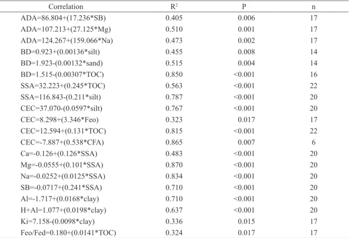
A high proportion of silt in relation to clay (silt/ clay ratio) suggests an intermediate degree of weathering in the studied soils (Embrapa, 2013). This is consistent with the relatively recent sediments from which the soils were formed and the low soils landscape positions, that may have inhibited a high weathering degree. The levels of clay dispersed in water showed a positive relationship with the sum of bases, mainly with the amounts of soil magnesium and sodium (Table 4), expressed through the lower of flocculation degrees the clays, as found in floodplains soils in Paraíba state by Correa et al. (2003).
Table 2: Main morphological attributes of lowland soils in the Metropolitan Region of Porto Alegre, RS.
Hor. Depth(cm) Color Texture class3 Structure4 Consistence5
Matrix Mottle
P1 - cambisolic Eutrophic Ta Haplic Gleysol
A 0-18 10YR 3/3 - Clay M, S/M, AB Fr, PL and S
Bg 18-43 10YR 3/2 5YR 5/8 Clay to very clayey M, M, AB P, SS/S
BCg 43-60 5YR 3/2 10YR 6/6 Clay MS F, P and S
Cg 60-80+ 5YR 3/2 10YR 6/6 Clay MS/G, AB Fr, P and S
P2 - cambisolic Dystrophic Ta Haplic Gleysol
Ap 0-5 7.5YR 4/2 - Clay-loam M, S/M, SB Fr, P and S
A1 5-23 10YR 4/2 - Clay-loam W, L, BS/MS F, P and S
ABg 23-40 10YR 4/2 7.5YR 4/6 Clay-loam M, L, SB VF/F, P and S
2Bg1 40-76 10YR 5/2 10YR 5/6 Clay-loam to clay M/W, L, P VF, P and S
3Bg2 76-95+ 10 YR 5/2 10 YR 5/6 Clay-loam to clay M/W, L, P SFr, P and S P3 - neofluvisolic Eutrophic Ta Haplic Gleysol
A1 0-13 2.5Y 4/1 5YR 4/4 Clay-loam W, VL, SB F, SP and SS
2Cg1 18/22-35 2.5Y 4/1 5 YR 4/4 Clay-loam W, VL, SB/MS F, NP and NS
2Cg2 35-70 2.5Y 5/1, 2.5Y 6/2, 5YR 8/12 Clay-loam MS L/VF, NP and NS
3Cg3 70-90+ 3/10 BG - Clay-loam MS F, SP and NS
P4 - solodic Haplic Eutrophic Planosol
Ap 0-7 10YR 3/3 - Sandy loam M, S, G F, SP and LPJ
A 7-23 10YR 4/4 7.5YR 5/8 Loamy sand to sandy loam M, M/L, SB F, SP and LPJ
AB 23-50/54 10YR 4/2 7.5YR 5/8 Clay-loam M, M, SB P and S
Btg 50/54-90+ 10YR 3/1 2.5YR 4/8,10YR 6/81 Clay M, M/L, P/SB Fr, P and S P5 - plinthosolic Dystrophic Haplic Planosol
Ap 0-24 2.5Y 3/3 10R 4/6 Loam M, M, SB/G VF, SP and NPJ
A 24-29/32 10YR 4/2 - Loam M, M, SB Fr, SP and LPJ
E 29/32-60/85 7.5YR 4/2 7.5YR 5/6 Loam M, M/L, AB Fr, SP and LPJ
Btg 60/85-120+ 10YR 4/1 2.5 YR 4/87.5YR 5/8,1 Clay M, M/L, SB Fr, P and VS P6 - typic Sapric Haplic Organosol
H1 0-22 Black 2.5/N, - Muck M, M, C SFr, NP and NS
H2 22-46 Black 2.5/N - Muck W, M, C F, SP and SS
H3 46-100+ Black 2.5/N - Muck MS F, SP and SS
1Plinthite; 2Variegate; 3Inferred at the field soil description; 4Structure: development degree (W: weak, M: moderate), size (S: small,
M: medium, L: large, VL: very large), type (G: granular, C: crumb, SB: subangular blocky, AB: angular blocky, P: prismatic, MS: massive); 5Consistence: when moist (L: Loose, VF: very friable, F: friable, SFr: slightly firm, Fr: firm), when wet (NP: nonplastic,
Table 3: Main physical attributes of lowland soils in the Metropolitan Region of Porto Alegre, RS.
Hor. dispersible water
clay clay silt FS CS
total
sand FS/CS %
FD silt/
clay PD BD SSA
--- g kg-1 --- ---- g cm-3 ---- m2 g-1 P1 - cambisolic Eutrophic Ta Haplic Gleysol
A 185 260 410 291 39 330 7.5 29 1.6 2.38 1.38 29.6
Bg 315 400 373 179 49 228 3.7 21 0.9 2.41 1.42 53.3
BCg 245 290 339 183 188 371 1.0 16 1.2 - 1.41 36.7
Cg 238 310 318 328 44 372 7.5 23 1.0 - - 47.0
P2 - cambisolic Dystrophic Ta Haplic Gleysol
Ap 69 187 493 283 37 320 7.6 63 2.6 2.47 1.62 6.1
A 102 205 495 279 21 300 13.3 51 2.4 2.52 1.77 7.4
ABg 117 220 510 249 21 270 11.9 47 2.3 - 1.64 6.1
2Bg1 206 260 523 212 5 217 42.4 21 2.0 - 1.67 3.9
3Bg2 217 265 455 267 13 280 20.5 18 1.7 2.51 1.76 7.4
P3 - neofluvisolic Eutrophic Ta Haplic Gleysol
A - 96 222 650 33 682 19.7 - 2.3 2.49 0.94 78.4
2Cg1 - 70 70 847 13 860 65.2 - 1.0 - - 84.6
2Cg2 - - -
-3Cg3 - 65 353 458 188 582 2.4 - 5.4 2.53 - 70.0
P4 - solodic Haplic Eutrophic Planosol
Ap 84 144 440 244 172 415 1.4 42 3.1 2.48 1.51 28.7
A 159 160 399 179 263 441 0.7 1 2.5 2.53 - 24.6
AB 190 280 310 147 263 410 0.6 32 1.1 2.48 1.49 45.2
Btg 339 420 257 125 198 324 0.6 19 0.6 2.48 1.42 90.6
P5 - plinthosolic Dystrophic Haplic Planosol
Ap 128 153 568 253 27 279 9.4 17 3.7 2.50 1.38 13.8
A 83 149 441 371 40 410 9.3 44 3.0 2.50 - 5.8
E 79 160 504 307 30 336 10.2 51 3.2 2.53 - 11.9
Btg 233 355 359 246 40 286 6.2 34 1.0 2.59 1.36 34.3
P6 - typic Sapric Haplic Organosol
H1 7 - - - 0.26 135.6
H3 7 - - - 0.14 139.7
FD (floculation degree), PD (particle density), BD (bulk density), SSA (specific surface area), FS (fine sand), CS (coarse sand).
Chemical characterization
The high total organic carbon (TOC) in the profile P6 horizons (between 410 and 453 g kg-1) (Table 5) indicates an intense paludization process in this locale, confirming the description of the material as of turfy
in the surface and decreased at depth. In Profile P3, this decrease was followed by an increase in the 3Cg3 horizon, corroborating the occurrence of a lithological discontinuity also expressed by the grain size of that horizon (Table 3).
The pH values in water were low, most under 5.5, except for the Cg1 horizon of profile P3 and horizons A and E of the P5 profile, the latter probably was influenced by its recent use under irrigated rice. In the P6 profile, the soil reaction was strongly acidic (4.1 to 4.3), as a result of the organic character of this soil. The higher pH values in water compared to the pH values in KCl indicate the predominance of a net negative charge in all soils. The cation exchange capacity (CEC) ranged from 5.7 to 33.3 cmolc kg-1 in the mineral soils. According to the CQFS-RS / BS (2004), the CEC values in the profiles P2 and P5 were classified as medium (5.7 to 11.9 cmolc kg-1), followed by
the profiles P1 and P4 with values classified as medium to high (9.1 to 22.4 cmolc kg-1), and profile P3 with values classified as high ( 26.9 to 33.3 cmolc kg-1). In these mineral soils, the content of silt and Fe relative to the poorly crystallized iron oxides (Feo) (e.g. ferrihydrite and lepidocrocite) was positively related to CEC (Table 4), possibly because the poor drainage inhibits weathering while favors the formation of poorly crystallized iron oxides. The high CEC values determined in the P6 profile (64.4 and 73.4 cmolc kg-1) occurred due to the organic character of the soil (Souza Júnior et al., 2001), as was expressed by the positive relationship with TOC (Table 4). A relation between CEC and clay fraction activity (CFA) in subsurface horizons B or C of most of the mineral soils was found. The CFA values were above 27 cmolc kg-1 of clay, characterizing high clay-activity in the soils (Embrapa, 2013).
Table 4: Correlation among physical and chemical properties determined for the lowland soils studied.
Correlation R2 P n
ADA=86.804+(17.236*SB) 0.405 0.006 17
ADA=107.213+(27.125*Mg) 0.510 0.001 17
ADA=124.267+(159.066*Na) 0.473 0.002 17
BD=0.923+(0.00136*silt) 0.455 0.008 14
BD=1.923-(0.00132*sand) 0.515 0.004 14
BD=1.515-(0.00307*TOC) 0.850 <0.001 16
SSA=32.223+(0.245*TOC) 0.563 <0.001 22
SSA=116.843-(0.211*silt) 0.787 <0.001 20
CEC=37.070-(0.0597*silt) 0.767 <0.001 20
CEC=8.298+(3.346*Feo) 0.323 0.017 17
CEC=12.594+(0.131*TOC) 0.815 <0.001 22
CEC=-7.887+(0.538*CFA) 0.865 0.007 6
Ca=-0.126+(0.126*SSA) 0.483 <0.001 20
Mg=-0.0555+(0.101*SSA) 0.870 <0.001 20
Na=-0.0252+(0.0125*SSA) 0.834 <0.001 20
SB=-0.0717+(0.241*SSA) 0.710 <0.001 20
Al=-1.717+(0.0168*clay) 0.710 <0.001 20
H+Al=1.077+(0.0198*clay) 0.637 <0.001 20
Ki=7.158-(0.0098*clay) 0.336 0.015 17
Feo/Fed=0.180+(0.0141*TOC) 0.324 0.017 17
Table 5: Chemical properties including C and P for the lowland soils studied in the Metropolitan Region of Porto Alegre, RS.
Hor. pH TOC Ca2+ Mg2+ Na+ K+ SB Al3+ H+Al CEC P m ESP V CFA
H2O KCl g kg-1 --- cmolc kg-1--- mg L-1 ---%--- cmolc kg-1 P1 - cambisolic Eutrophic Ta Haplic Gleysol
A 4.9 3.8 14.3 3.2 3.1 0.18 0.25 6.7 1.5 7.1 13.8 3.4 18 1 49
-Bg 4.7 3.6 6.1 2.6 5.0 0.41 0.20 8.2 5.8 10.4 18.6 2.7 41 2 44 46.5
BCg 4.3 3.5 3.5 2.5 4.7 0.39 0.17 7.8 4.8 5.9 13.7 2.5 38 3 57 47.1
Cg 4.5 3.6 2.3 2.9 6.2 0.71 0.19 10.0 4.4 8.4 18.4 2.5 31 4 54
-P2 - cambisolic Dystrophic Ta Haplic Gleysol
Ap 5.1 - 11.0 1.3 0.9 0.04 0.06 2.4 0.6 3.6 6.1 19.5 19 1 39
-A 5.4 - 7.1 1.6 0.9 0.05 0.05 2.7 0.6 3.0 5.7 13.9 19 1 47
-ABg 4.9 - 3.9 2.4 0.8 0.05 0.03 3.2 0.5 3.6 6.8 14.1 12 1 48
-2Bg1 5.1 - 3.3 1.3 0.4 0.06 0.03 1.8 2.3 5.8 7.6 1.4 58 1 23 29.0
3Bg2 4.6 - 1.9 0.8 0.5 0.13 0.04 1.6 2.6 6.9 8.5 0.9 64 2 17 32.0
P3 - neofluvisolic Eutrophic Ta Haplic Gleysol
A 5.1 4.0 25.3 13.5 7.7 0.62 0.13 22.0 0.5 4.9 26.9 5.2 2 2 82
-2Cg1 5.7 4.3 3.5 19.5 11.6 1.11 0.10 32.3 0.0 1.0 33.3 4.0 0 3 97
-2Cg2 - - - -
-3Cg3 5.4 3.9 10.7 14.5 6.1 0.80 0.36 21.8 0.3 5.6 27.4 9.8 1 3 80
-P4 - solodic Haplic Eutrophic Planosol
Ap 5.0 4.0 34.4 2.6 2.9 0.31 0.31 6.1 1.6 3.1 9.2 7.9 21 3 66
-A 4.8 3.9 4.6 1.3 1.5 0.16 0.18 3.1 1.6 6.0 9.1 2.7 34 2 34
-AB 5.1 3.7 5.2 1.4 2.6 0.43 0.17 4.6 4.3 7.4 12.0 1.3 48 4 38
-Btg 5.0 3.7 4.4 3.0 7.8 1.49 0.23 12.5 5.6 9.9 22.4 2.2 31 7 56 53.4
P5 - plinthosolic Dystrophic Haplic Planosol
Ap 4.9 4.0 11.8 2.0 0.7 0.10 0.21 3.0 0.5 5.2 8.2 - 14 1 37
-A 5.8 4.9 4.8 2.8 1.3 0.12 0.17 4.2 0.0 2.4 6.6 13.5 0 2 65
-E 6.5 5.4 4.1 2.6 1.7 0.33 0.36 5.0 0.0 2.4 7.4 3.1 0 5 68
-Btg 4.9 3.7 3.7 2.1 2.0 0.55 0.24 4.9 2.9 7.0 11.9 2.0 38 5 41 33.5
P6 - typic Sapric Haplic Organosol
H1 4.1 3.3 410.1 7.1 5.0 0.30 0.20 12.6 3.7 51.8 64.4 6.8 23 1 20 -H3 4.3 3.3 453.0 7.8 7.2 0.55 0.10 15.6 3.3 57.8 73.4 5.0 17 1 21
The composition of sorption-complex of soils showed strong relationship with SSA values and clay content (Table 4). Profiles P2 and P5, under less intense hydromorphic conditions, showed the lowest levels of basic cations (S≤5 cmolc kg-1) and exchangeable Al3+ contents ranging from 0.5 kg cmolc-1 in the surface to 2.9 cmolc kg-1 at depth. In these profiles, the V values decreased and m increased at depth. In the P1 and P4 profiles, cation contents were intermediate (between 3 and 11 cmolc kg-1) associated with high exchangeable Al3+ levels, resulting in intermediate V and m values. In this profile the Na+ saturation (ESP) in the Btg horizon stands out, characterizing the solodic nature of this soil (Embrapa, 2013). In Profile P3 there were very high levels of basic cations (> 20 cmolc kg-1) and a virtual lack of exchangeable Al3+, resulting in very high V values (≥ 80%) and low m (≤ 2%). In Profile P6, with an organic material character, the cations and Al3+ contents were high, with low V and m values due to high organic contribution of H+ in the exchange complex. The P contents ranged from low to very low in the P1 profile and in the subsurface in profiles P2, P4 and P5, to high and very high in the surface horizons of profiles P2, P3, P4 and P5. In Profile 6 the P content was considered average.
The total contents of the elements extracted by sulfuric acid attack in mineral soils are presented in Table 6. The P2O5 content and MnO were below 1 g kg-1. The low amounts of Fe2O3 and MnO are possibly related to reduction processes and removal of manganese and iron occurring in wetland soils (Corrêa et al., 2003; Coringa et al., 2012). The SiO2 contents were greater than the Al2O3 contents in all soils, contributing to the high Ki index values in most of the horizons (Table 6), which indicated the 2:1 occurrence of clay minerals. The iron concentrations related to the total pedogenic iron oxides (Fed) had a distribution similar to the Fe2O3 content
between horizons and profiles analyzed. However, the Fed concentrations were lower than those of the total Fe (extracted by sulfuric acid attack) as indicated by Fed/ Fet relationship (between 0.13 and 0.65), confirming the incipient stage of development and the conditions for preservation and/or neoformation of silicate minerals in the clay fraction (Moniz; Buol, 1982; Kämpf; Curi, 2000), indicated by the Ki ratio. The low Feo/Fed values of the subsurface layers, indicating the predominance of crystalline iron oxides, contrasted with the increase of the surface horizons determined by inhibition by organic matter in the development of the iron oxide crystallinity (Schwertmann, 1966; Biber; Santos; Stumm, 1994). Soil classification
Table 6: Total content of oxides from sulfuric acid digestion, Ki index and Fe from selective extractions for the lowland soils studied in the Metropolitan Region of Porto Alegre, RS.
Hor.
Sulfuric acid digestion (H2SO4 1:1)
Ki Fed Feo Feo/Fed Fed/Fet
P2O5 Fe2O3 MnO TiO2 Al2O3 SiO2
--- gkg-1 --- ---- gkg-1 ----P1 - cambisolic Eutrophic Ta Haplic Gleysol
A 0.3 17.0 0.3 6.2 50.5 133.0 4.52 3.6 0.8 0.22 0.21
Bg 0.2 45.0 0.3 7.0 98.5 195.5 3.40 14.7 2.5 0.17 0.33
BCg - - -
-C 0.1 25.0 0.2 6.2 82.5 178.0 3.72 3.8 0.3 0.08 0.15
P2 - cambisolic Dystrophic Ta Haplic Gleysol
Ap 0.5 5.9 0.1 3.8 17.2 71.0 6.97 2.5 1.3 0.52 0.42
A 0.6 6.8 0.1 3.9 19.0 72.5 6.50 2.5 1.7 0.68 0.37
ABg - - -
-2Bg1 0.2 7.2 0.1 4.7 22.3 86.0 6.53 3.8 0.9 0.24 0.53
3Bg2 0.2 20.7 0.1 5.0 34.8 115.0 5.64 13.4 0.9 0.07 0.65
P3 - neofluvisolic Eutrophic Ta Haplic Gleysol
A 0.6 7.2 0.1 4.0 23.1 98.0 7.21 2.9 1.8 0.62 0.40
2Cg1 0.6 90.0 1.7 3.0 31.0 142.0 7.78 12.0 3.8 0.32 0.13
2Cg2 - - -
-3Cg3 0.6 71.5 1.5 3.1 29.5 137.5 7.93 10.8 6.4 0.59 0.15
P4 - solodic Haplic Eutrophic Planosol
Ap 0.5 13.0 0.4 4.7 37.0 110.0 5.04 3.0 1.4 0.47 0.23
A 0.2 21.0 0.1 5.0 57.0 111.0 3.30 4.7 0.9 0.19 0.22
AB - - -
-Btg 0.2 34.0 0.3 6.2 118.0 224.7 3.29 14.1 1.1 0.08 0.41
P5 - plinthosolic Dystrophic Haplic Planosol
Ap 0.4 17.0 0.2 6.7 30.5 74.0 4.14 5.5 2.8 0.51 0.32
A 0.5 11.0 0.8 5.6 21.0 61.0 4.93 4.7 1.6 0.34 0.43
E 0.1 25.0 0.1 3.6 15.0 37.0 2.11 9.7 0.8 0.08 0.39
Btg 0.1 53.7 0.3 8.2 82.8 142.0 2.91 22.3 0.9 0.04 0.42
CONCLUSIONS
The floodplain soils of the Porto Alegre metropolitan region show differences in morphological, physical and chemical characteristics, the main factors responsible are the source material and the degree of hydromorphism. The high silt/clay relationship, the occurrence of high clay activity, the high Ki index values and the low Fed/ Fet relationship indicate that the soils show some degree of incipient weathering. The degree of hydromorphism,
basic cation contents expressed by the eutrophic and dystrophic attributes. The influence of soil organic matter on chemical properties such as specific surface area and cation exchange capacity, and physical attributes such as bulk density reinforces its importance for the sustainability of the environment.
ACKNOWLEDGMENTS
To the Conselho Nacional de Desenvolvimento Científico e Tecnológico (CNPq) for the financial support (Edital Universal). To the Coordenação de Aperfeiçoamento de Pessoal de Nível Superior (CAPES) and Fundação de Amparo à Pesquisa do Estado de Minas Gerais (FAPEMIG).
REFERENCES
BIBER, M. V.; DOS SANTOS, M.; STUMM, W. The coordination chemistry of weathering: IV: Inhibition of the dissolution of oxide minerals. Geochimica et Cosmochimica Acta. 58:1999-2010, 1994.
BRASIL. Ministério da Agricultura. Divisão de Pesquisa
Pedológica. Levantamento de reconhecimento dos
solos do Rio Grande do Sul. (Boletim Técnico, 30).
Recife: DNPEA-MA, 1973. 431p.
COMISSÃO DE QUÍMICA E FERTILIDADE DO SOLO - CQFS RS/SC. Recomendações de adubação e calagem para os Estados do Rio Grande do Sul e de Santa Catarina. 10.ed. Porto Alegre: Sociedade Brasileira de Ciência do Solo - Núcleo Regional Sul, 2004. 400p.
CORINGA, E.A.O. et al. Atributos de solos
hidromórficos no Pantanal Norte Matogrossense. Acta
Amazonica. 42(1):19-28, 2012.
CORRÊA, M. M. et al. Atributos físicos, químicos e mineralógicos de solos da região das Várzeas de Sousa (PB). Revista Brasileira de Ciência do Solo. 27(2):311-324, 2003.
CPRM. Mapa geológico do Estado do Rio Grande do Sul. Escala 1:750.000. Projeto Geologia do Brasil ao Milionésimo. CD-ROM. 2006.
EMPRESA BRASILEIRA DE PESQUISA
AGROPECUÁRIA - EMBRAPA. Centro Nacional de Pesquisa de solos. Manual de métodos de análise de solo. 2.ed. Rio de Janeiro: EMBRAPA/CNPS-RJ, 1997. 212p.
EMPRESA BRASILEIRA DE PESQUISA
AGROPECUÁRIA - EMBRAPA. Sistema Brasileiro de Classificação de Solos. 3.ed. Brasília: Embrapa, 2013. 353p.
FINK, J. R. et al. Mineralogy and phosphorus adsorption in soils of south and central-west Brazil under conventional and no-tillage systems. Acta
Scientiarum. Agronomy. 36(3):379-387, 2014.
GUIMARÃES, S. T. et al. Caracterização e classificação de gleissolos da várzea do Rio Solimões (Manacapuru e Iranduba), Amazonas, Brasil. Revista Brasileira de
Ciência do Solo. 37(2):317-326, 2013.
HASENACK, H. et al. Vegetação e ocupação. In: HASENACK, H. et al. (Coord.). Diagnóstico Ambiental de Porto Alegre: Geologia, Solos, Drenagem,
Vegetação/ Ocupação e Paisagem. Porto Alegre: Secretaria Municipal do Meio Ambiente, 2008. p.56-71. IBGE. Levantamento de recursos naturais do projeto RadamBrasil. Folha SH.22. Porto Alegre e parte das folhas SH. 21 Uruguaiana e Si. 22 Lagoa Mirim. Rio de Janeiro: IBGE, 1986. 796p.
INDA JUNIOR, A. V.; KÄMPF, N. Avaliação de
procedimentos de extração dos óxidos de ferro pedogênicos com ditionito-citrato-bicarbonato de sódio. Revista Brasileira de Ciência do Solo. 27(6):1139-1147, 2003. KÄMPF, N.; CURI, N. Óxidos de ferro: Indicadores de ambientes pedogênicos. In: NOVAIS, R. F.; ALVAREZ, V. H.; SCHAEFER, C.E.G.R., (Eds.) Tópicos em Ciência do Solo. Viçosa: Sociedade Brasileira de Ciência do Solo, 2000. v.1, p.107-138.
MALUF, J.R.T. Nova classificação climática do Estado do Rio Grande do Sul. Revista Brasileira de Agrometeorologia. 8(1):141-150, 2000.
MEHRA, O. P.; JACKSON M. L. Iron oxide removal from soils and clays by a dithionite-citrate system buffered with sodium bicarbonate. Clays and Clay Minerals. 7:317-327, 1960.
NOVAES FILHO, J. P. et al. Indicativos de
descontinuidade litológica de regolitos derivados de granitos em uma microbacia sob floresta Amazônica, em Juruena - MT. Revista Brasileira de Ciência do Solo. 36(2), 317-324, 2012.
OLIVEIRA, L. B. et al. Classificação de solos planossólicos do Sertão do Araripe (PE). Revista Brasileira de Ciência do Solo. 27(4):685-693, 2003.
QUIRCK, J. P. Significance of surface areas calculated from water vapour sorption isotherms by use of B.E.T. equation. Soil Science. 80:423-430, 1955.
RADAMBRASIL. Levantamento de recursos Naturais. Folha SH 22 – Porto Alegre e parte das Folhas SH 21 – Uruguaiana e SI 22 – Lagoa Mirim. Rio de Janeiro: Fundação Instituto Brasileiro de Geografia Estatística. 1986. 796p.
SANTOS, R. D. et al. Manual de descrição e coleta de solo no campo. 5.ed. Viçosa: SBCS/SNLCS, 2005. 100p.
SCHNEIDER, A. W.; LOSS, E. L.; PINTO J. F. Mapa geológico da Folha de Porto Alegre - RS. Porto Alegre: Instituto de Geociências - Universidade Federal do Rio Grande do Sul. 1974. Mapa.
SCHNEIDER, P. et al. Solos de Porto Alegre. In: HASENACK; H. et al. (Coord.). Diagnóstico Ambiental
de Porto Alegre: Geologia, Solos, Drenagem, Vegetação/ Ocupação e Paisagem. Porto Alegre: Secretaria Municipal do Meio Ambiente, 2008. p.28-43.
SCHWERTMANN, U. Differenzierung der eisenoxide des bodens durch extraktion mitammoniumoxalat-lösung. Zeitschrift Fur Pflanzenernährung Und Bodenkunde. 105:194-202, 1964.
SCHWERTMANN, U. Inhibitory effect of soil organic matter on the crystallization of amorphous ferric hydroxide. Nature. 212:645-646, 1966.
SOUZA JUNIOR, V. S.; RIBEIRO, M. R.; OLIVEIRA, L. B. Propriedades químicas e manejo de solos
tiomórficos da várzea do Rio Coruripe, Estado de Alagoas. Revista Brasileira de Ciência do Solo. 25(4):811-822, 2001.