Accessing Meteorological Data
in INSPIRE
Accessing Meteorological Data in INSPIRE
Dissertation supervised by
Carlos Granell, PhD
Dept. Lenguajes y Sistemas Informaticos Universitat Jaume I, Castellón, Spain
Co-supervised by
Sven Schade, PhD
Institute for Environment and Sustainability
European Commission - Joint Research Centre (JRC), Italy
Rui Pedro Juliao, PhD
Instituto Superior de Estatística e Gestão da Informação Universidade Nova de Lisboa, Lisbon, Portugal
ACKNOWLEDGMENTS
I would like to express my deepest gratitude to my supervisors Carlos Granell, Sven Schade and Rui Pedro Juliao, who have been always supportive, encouraging and guiding me with all their suggestions throughout my thesis. I really appreciate their effort.
I am extremely grateful to Dominic Lowe and Andrew Woolf for their valuable suggestions and providing me with all the technical help through out the thesis. I would also like to thank STFC, UK for sponsoring me to attend the GIS/OGC meeting in Toulouse, France which gave me an opportunity to achieve more knowledge and gain experience in research.
I would also like to extend my warm thanks to Chris Little, UK Met Office and Ben Caradoc Davies, CSIRO-‐Australia for all their valuable suggestions and timely help.
I acknowledge IBL Soft, Bratislava and NOAA for providing me the BUFR data for my research.
I would like to thank all my professors and staff of this masters program for their inspiration and guidance. I would also like to thank Laura, Jose and Alain for their advice and assistance.
I would like to thank all my classmates for the all the wonderful time we had near the Aasee, Tascas and Bairo.
Accessing Meteorological data in INSPIRE
ABSTRACT
KEYWORDS
Meteorology
CSML
INSPIRE
Download Service
OGC
ACRONYMS
API - Application Programming Interface
BADC - British Atmospheric Data Center
BUFR - Binary Universal Form of Representation Meteorological data
CF Convention - Climate and Forecast Convention
COWS - Ceda OGC Web Service
CSML - Climate Science Modeling Language
EC - European Commission
EU - European Union
EUMETSAT - European Organization for the Exploitation of Meteorological Satellites
FTP - File Transfer protocol
GEMET - General Environmental Multi-lingual Thesaurus
GML - Geography Markup Language
GRIB - Gridded Binary
GSDI - Global Spatial Data Infrastructure
HDF - Hierarchical Data Format
HTTP - Hyper Text Transfer Protocol
IDE - Integrated Development Environment
INSPIRE - Infrastructure for Spatial Information in Europe
ISO - International Organization for Standardization
JRC - Joint Research Center
METAR - Aviation Routine Weather Report
MS - Member State
NCDC - National Climatic Data Center
NERC - Natural Environment Research Council
NetCDF - Network Common Data Form
NOAA - National Oceanic and Atmospheric Administration
NWP - Numerical Weather prediction
OGC - Open Geospatial Consortium
SDI - Spatial Data Infrastructure
SOS - Sensor Observation Service
UML - Unified Modeling Language
UN - United Nations
WCS - Web Coverage service
WFS - Web Feature Service
WPS - Web Processing Service
WMS - Web Map Service
WMO - World Meteorological Organization
Table of Contents
ACKNOWLEDGMENTS...i
ABSTRACT...ii
KEYWORDS……….iii
ACRONYMS...iv
LIST OF TABLES…...viii
LIST OF FIGURES…...….ix
1. INTRODUCTION...1
1.1 Motivation...2
1.2 Problem Statement ...3
1.3 Research Questions and Objectives ...4
1.4 Methodology...4
1.5 Structure of the Thesis...6
2. BACKGROUND...7
2.1. Interoperability ...7
2.2. INSPIRE and the Need for Sharing Geospatial Information Services...9
2.3. INSPIRE Network Services...10
2.4. Meteorological Data...14
3. METHODOLOGY AND CONCEPTUAL MAPPING...20
3.1. Methodology for Accessing Meteorological Data...…………...20
3.2. Conceptual Mapping from BUFR to CSML……...………...21
4. IMPLEMENTATION...27
4.1. Conversion of Meteorological Data (BUFR) to XML...…...….28
4.2. Mapping of BUFR XML to CSML Features using CF Convention...30
4.3. CSML Parser to Access XML Features...30
4.4. Accessing CSML through OGC Web Services...32
4.5. INSPIRE Download Service for Meteorological Data...33
5. DISCUSSION OF RESULTS...…....….34
5.2. CSML Mapping...…...34
5.3. Accessing CSML through OGC Web Services...…...35
5.4. Suitable INSPIRE Download Services...….37
6. CONCLUSIONS AND FUTURE WORK...…..39
6.1. Conclusions...…..39
6.2. Future Work...…..40
7. REFERENCES………...42
LIST OF TABLES
Table 1: Technical overview of INSPIRE Download Service with description………...13
Table 2: Similarity between OGC WFS and INSPIRE Download Service functionalities……..13
Table 3: CSML Features and their descriptions………...15
Table 4: BUFR Data category defined by WMO…...18
Table 5: SYNOP attributes obtained after conversion into XML output along with their descriptions...22
Table 6: METAR attributes obtained after conversion into XML output along with their descriptions...23
Table 7: Potential mapping between SYNOP XML attributes to CSML feature types...24
Table 8: Potential mapping between METAR XML attributes to CSML feature types...25
LIST OF FIGURES
Figure 1: The proposed overall methodology which would be followed to achieve the
objectives...5
Figure 2: INSPIRE service types……….………...11
Figure 3:This Figure shows the proposed methodology that would be followed for the
thesis……….………20 Figure 4: BUFR XML to CSML mapping...21
Figure 5: The implementation architecture………..……….27
Figure 6: This shows the Wmobufr package files on NetBeans 6.8 used to convert
BUFR to XML...29
Figure 7: This shows the Online parser screenshot available at the CSML website...31 Figure 8: This figure shows the three tables in a database are accessed using GeoServer
1. INTRODUCTION
In the information age, information has become of vital importance to the economic and social
development of a country (Okediji, 2004). Geographic information, in particular, is of increasing
importance for the successful execution of public tasks (Bregt et al, 2006). Spatial Data
Infrastructure (SDI) facilitates the collection, maintenance, dissemination, and use of spatial
information (Nebert, 2004, Gruz et al, 2007). SDI could produce significant human and resource
savings and returns by reducing duplication and facilitating integration (Crompvoets, 2006). Data
exchange systems and data management practices ensure effective and efficient international use of
the data regardless of location or language (Schiessl, 2007).
The general situation of spatial information is one of fragmented datasets and sources, gaps in
availability, lack of harmonization between datasets at different geographical scales and duplication
of information collection (JRC, 2009). These problems make it difficult to identify, access and use data that are available (EC, 2007). The Infrastructure for Spatial Information in Europe (INSPIRE)
was established as a means of addressing the issues concerning environmental data within the
European Union (EU) (INSPIRE, 2004). INSPIRE, in general aims at using maintained local data
sets for serving geospatial data with European coverage (EC, 2007). Awareness is growing at both
national and EU level about the need for quality geo-referenced information to support
understanding of the complexity and interactions between human activities and environmental
pressures and impacts (Villa, 2008). The target users of INSPIRE include policy-makers, planners
and managers at European, national and local level and the citizens and their organizations (JRC,
2009). An INSPIRE Download Service is a web service that provides access to the full extent of
geographic and thematic information in data sets belonging to the themes covered by the INSPIRE
Directive Annexes (INSPIRE, 2009).
The Open Geospatial Consortium (OGC) is a non-profit, international, voluntary consensus
standards organization that is leading the development of standards for geospatial and location
based services (OGC, 2010). It comprises companies, government organizations and universities
participating in development of standards.While the OGC is a global organization and the work is
applied in different ways around the world, Non OGC members along with European member states
the environment and security. OGC and INSPIRE both have combined interests to achieve data
harmonization across the globe and supports each other.
The development of the Earth System Science field has led to an increased requirement for
scientific analysis across application domains (Lawrence et al, 2008). There is a growing need for
interoperability of data in climate sciences for data assimilation, verification studies and model inter
comparison projects from multiple sources (Woolf et al, 2005). Meteorology is the interdisciplinary
scientific study of the atmosphere that focuses on weather processes and forecasting. Meteorology
has application in many diverse fields such as the military, energy production, transport, agriculture
and construction. Weather data comes in a variety of forms from a number of sources and these data
can be obtained from human reports, in situ instruments, or remote sensors (Bell, 2004). Forecasters
use meteorological data to support a number of programs including aviation, fire and marine.
Weather data supports a wide range of scientific fields and helps decision makers in various fields.
This thesis aims to demonstrate interoperability and accessibility between Meteorological data for
various users and suggest an appropriate INSPIRE Download Service for meteorological data.
1.1 Motivation
The ability to easily exchange atmospheric, meteorological and climatological information in a
timely and useful fashion is becoming increasingly important (Little and Woolf, 2009).
Meteorological data is multidimensional, continually evolving, highly spatial and highly temporal
in nature. Measurements are taken at many locations on regular and irregular time intervals and are
often assimilated into numerical weather prediction (NWP) models which produce gridded
simulations and even simulated forecast ‘observations’ which may be for hours, days, weeks, or
even centuries into the future, or past. These data can have multiple time attributes (Little and
Woolf, 2009).
There are many diverse groups with an interest in this information, ranging from national agencies
to private weather services, the general public, defense and aviation, transportation, national
infrastructures, and even financial institutions (Woolf et al, 2005). The information is used for
safety critical purposes, planning, research, and as the basis for many decisions. The ability to
provide consistent information on a timely basis to each of these stakeholders is paramount.
The meteorology domain is a core theme in many SDI’s (Woolf et al, 2005). Existing SDI’s (Nebert
various users using standardized web services. A Web Service is a software system designed to
support interoperable machine-to-machine interaction over a network (Haas and Brown, 2004).
Web Services are self-contained, self-describing, modular applications that can be published,
located, and invoked across the Web (Doyle and Reed, 2001). These services should allow the users
to identify and access spatial or geographical information from a wide range of sources, from the
local level to the global level, in an interoperable way for a variety of uses. The WMO (World
Meteorological Organization) is a specialized agency of United Nations (UN). It is the UN system's
authoritative voice on the state and behavior of the Earth's atmosphere, its interaction with the
oceans and the climate which produces the resulting distribution of water resources (WMO, 2009).
1.2 Problem Statement
INSPIRE is trying to combine spatial data from different sources across the community in a
consistent way and share them between several users and applications. The INSPIRE Download
Service provides capability to access the information to fulfill a series of possible tasks including
visualizing information in a variety of ways, integration with other information, and to allow deep
analysis as a basis for knowledge and decision making (INSPIRE, 2009).
WMO members have a large amount of data but in different data formats and based on different
underlying conceptual models like BUFR, GRIB, NetCDF, HDF (Tveito, 2006). BUFR is the
commonly used WMO’s binary standard exchange format. These are table driven codes and have
been widely adopted and used for the distribution of meteorological satellite products. BUFR is a
large file which has more than 255 data category described by WMO and is used by many
communities. SYNOP, METAR and TEMP are some of the commonly used formats of BUFR data.
SYNOP is a format used for reporting general weather observations made by manned and
automated weather stations. METAR is a format used for reporting weather by meteorologists but
predominantly used by pilots for pre flight weather briefing.
CSML (Climate Science Modeling Language) is a standard based data model described in Unified
Modeling Language (UML), and a XML mark up language which implements the CSML data
model (Woolf et at, 2006). Geography Markup Language (GML) is the XML grammar defined by
the OGC to express geographical features (OGC, 2010). As CSML is a GML application schema, we prefer to use CSML to access BUFR data through OGC services. The main problem, in the
context of SDI standards, is providing access to meteorological data in the format required by end
this problem.
1.3 Research Questions and Objectives
The overarching aim of this thesis is to select a suitable INSPIRE Download Service for
meteorological data and propose an architecture to access meteorological data. To achieve these
goals, the following research questions have been selected.
1.Which type of service could be a suitable candidate as INSPIRE Download Service for
Meteorological Data?
2.How well can formats like BUFR be accessed?
3.What is the role of CSML in the architecture?
The objectives for this thesis can be divided into overall objectives which focus on broader issues
and practical/technical objectives which are steps identified to achieve the overall objectives.
The overall objectives identified for this thesis are:
• To test whether the CSML model and OGC standards can be used to wrap Meteorological data
from multiple types of data
• To analyze various options to access meteorological data from CSML model.
• To investigate the mapping of meteorological data to INSPIRE services.
• To select an appropriate download service from INSPIRE for a given data set (Meteorological).
The practical/technical objectives identified for this thesis are:
• To analyze BUFR files.
• Conversion of BUFR into XML to be accessed through CSML.
• To map BUFR attributes to CSML features.
• To access CSML features using OGC web services.
• To suggest download service for INSPIRE for a Meteorological data (BUFR).
1.4 Methodology
The main goal of this thesis is to test whether BUFR data format all the way though can be accessed
through OGC web services and suggest a suitable INSPIRE Download Service for meteorological
BUFR subsets like SYNOP and METAR data will be analyzed to study the attributes or information
contained and then will be converted to XML file. These BUFR XML files will be mapped to
CSML features based on the mapping regime and later accessed using a CSML parser. GeoServer, a
open source software implementing OGC specifications will be used for accessing meteorological
data (BUFR XML) through CSML. Considering the testing of the OGC services, a suitable
download service will be suggested for INSPIRE for meteorological data and also look how OGC
services are related with INSPIRE Download Services.
Based on the Meteorological data set and of Download Service capabilities, we develop a
conceptual solution. Figure 1 shows the proposed overall methodology which will be followed to
achieve the above mentioned objectives (section 1.3). Suitable datasets from meteorology will be
selected and analyzed for its contents and then capabilities of INSPIRE Download Service would be
studied with its functionalities described by INSPIRE. Later meteorological datasets and
capabilities of INSPIRE Download Service would be conceptualized and based on the
understanding, a architecture would be implemented which can access meteorological data through
web services with capabilities of INSPIRE Download Service.
1.5 Structure of the Thesis
Chapter one is an introduction which includes motivation, problem statement, research objectives
and methodology of the research along with the structure of the thesis. Chapter two is a
comprehensive literature review on meteorological data which includes CSML, BUFR file formats,
OGC Web Services along with interoperability and INSPIRE. Chapter three covers the proposed
methodology and conceptual mapping. In Chapter four we describe our implementation and
Chapter five contains discussion of the results. Chapter six entails conclusions, recommendations,
2. BACKGROUND
Geospatial information is of vital importance in decision-making and policy support at various
levels of organizations, programs and activities. Geospatial information can be defined, at an
abstract level, as any information, data or document possessing a locational component which can
reference it to a location on the Earth (Groot and McLaughlin, 2000). Spatial Data Infrastructure
(SDI) supports discovery, access and use of geographic information in the decision-making process
(Nebert, 2004). Spatial data infrastructure in the European Community is of primary importance at
present as access to spatial data and services constitutes an important basis for environmental
policies used by all public authorities. INSPIRE (Infrastructure for spatial information in Europe) is
an initiative that recognizes the need to access and use spatial data and spatial data services
according to an agreed set of harmonized conditions (INSPIRE, 2009). For a SDI to be successful it
has to achieve interoperability at each level across different communities. INSPIRE and OGC along
with other organizations are working towards achieving interoperability across the world.
2.1 Interoperability
An information infrastructure can be defined as the idea of a transparent, robust computer
environment, which enables access to information using common, well-known and accepted
specifications, standards and protocols (GSDI, 2001). Interoperability is the ability of a system (or
component of a system) to access a variety of heterogeneous resources by means of a single,
unchanging operational interface (Canadian Geospatial Data Infrastructure Architecture Working
Group, 2001). Two resources (such as a client and a server) are interoperable when there is a
mutually agreed upon vocabulary for messaging which is understood by both. While
communications between them may relay different requests and responses, the two resources
understand the frameworks in which they are delivered (Hall and Leahy, 2008). Interoperability
dovetails with the open systems model, an approach to software engineering and system design
which enables and encourages sharing of resources (Gardels, 1999).
The geospatial information user community is exemplary of problems resulting from a lack of, or
ineffective use of, specifications and standards (Groot and McLaughlin, 2000). As mentioned by the
authors, standards initially provide three primary benefits for geospatial information (i) portability
use and reuse of information and applications, (ii) interoperability multiple system information
The Open Geospatial Consortium (OGC) which was formed in 1994, is a nonprofit, international,
voluntary consensus standards organization which consists of 389 companies, government agencies
and universities that is leading the development of standards for geospatial and location based
services (OGC, 2010). High-level standards (user interfaces, data formats, etc.) from such bodies as
ISO, OGC and FGDC are also used (United States National Research Council, 1999). The OGC
and the International Organization for Standardization (ISO) Technical Committee 211 are two
prominent standardization bodies in this field. OGC and ISO have identified areas of common
interest and work closely to ensure harmonization of efforts. ISO defines interoperability as the
"capability to communicate, execute programs, or transfer data among various functional units in a
manner that requires the user to have little or no knowledge of the unique characteristics of those
units” (ISO, 2005).
One of the earliest OGC specifications, which has now become incorporated in the ISO 19100
series of standards for geographic information, is the Web Map Service (WMS). The WMS
specification is a network accessible service that produces map images that are representations of
geospatial data. WMS was followed by the Web Feature Service (WFS) specification, which
provides an interface for remote access to geospatial data. Currently, a Web Processing Service
(WPS) specification version is being discussed, that provides remote access to processes that are
capable of performing calculations on spatial data (Johansson, 2006). Web Coverage Service
(WCS) defines a standard interface and operations that enables interoperable access to geospatial
coverages (OGC, 2010). Generally coverages refers to information such as satellite images, digital
aerial photos, digital elevation data and other phenomena which are represented by values taken at
each point of measurement (OGC, 2010). Sensor Observation Service (SOS) provides an
Application Programming Interface (API) for managing deployment of sensors and retrieving the
sensor data which is observation data (OGC, 2010). These observation data can be from in-situ
sensors (water monitoring) or dynamic sensors (satellite imaging).
A lot of consideration has been given in the designing of metadata models to describe the data. As
these Metadata models are in one end, the other end is also important which would consist of
delivering these data through geospatial delivery interfaces such as OGC implemented WMS, WFS
and WCS (Lowe et al, 2008).
using HTTP as the underlying protocol (Vretanos, 2005). WFS provides access to vector data and
is therefore fundamentally different from a WMS which produces mere raster image representations
of geospatial data as maps. WFS can be cascaded; it can serve data that is located at some remote
WFS. Geography Markup Language (GML) is the XML grammar defined by the OGC to express
geographical features and it also serves as a modeling language for geographic systems and carries
transaction of geographic formats over the internet (OGC, 2010). GML provides the basis for
domain or community specific application schemas, which supports data harmonization based on
the community using it (ISO, 2005). Application schemas are normally designed using ISO 19103
conformant UML. When transporting geospatial data, the interchange format is the GML and
conforms to some GML application schema.
The operations provided by the WFS are GetCapabilities, DescribeFeatureType, GetFeature,
GetFeatureWithLock, GetGMLObject, LockFeature and Transaction. The OGC WFS
implementation specification is in the process of being included in the ISO 19100 series of
standards for geographic information as ISO 19142 (ISO, 2005).
2.2 INSPIRE and the Need for Sharing Geospatial Information and Services
Presently, there is a global trend among nations and regions to develop frameworks that supports
ready access to geospatial information. Such a framework is called a SDI. Many definitions of SDI have been proposed over the years to make it fit into different local contexts. Masser provides a
general definition (Masser, 1995):
A spatial data infrastructure supports ready access to geographic information. This is achieved through the coordinated actions of nations and organizations that promote awareness and implementation of complimentary policies, common standards and effective mechanisms for the development and availability of interoperable digital geographic data and technologies to support decision making at all scales for multiple purposes. These actions encompass the policies, organizational remits, data, technologies, standards, delivery mechanisms, and financial and human resources necessary to ensure that those working at the (national) and regional scale are not impeded in meeting their objectives.
From this definition it is clear that implementing a SDI is a vast undertaking, involving not only
technical issues, such as data, technologies, standards, and delivery mechanisms, but also
institutional matters, related to organizational responsibilities and information policies.
data Infrastructure) based on national SDIs of member states, with a focus on environmental
information (Annoni and Smits, 2003). The policy makers in the European Union realized the
continuing issues affecting the society and recognized the need for a new approach across different
levels of government dealing with monitoring, reporting, data management and data delivery (DPLI
working group, 2002). Policies can be employed to reduce the duplication of data collection and to
assist and promote harmonization, broader dissemination and use of data. This would result in
increased efficiency with greater availability and high quality information (Boo, 2005).
As suggested by Bernard et al (2005), a common understanding of the geospatial information to be
shared in the ESDI needs to be defined along with a data interchange format for use with the
network services. Semantic interoperability is hampered by semantic heterogeneity, which occurs
when two geographic information communities use the same name for different phenomena, or
different names for the same phenomenon (Bishr, 1998). Use of spatial information across various
communities in Europe is usually restricted due to fragmentation or missing datasets, lack of
harmonization between different datasets and datasets differing in geographic scale and differing in
quality due to duplication in data collection (Bishr 1998). It has been estimated that INSPIRE could
improve quality and reduce costs for preparing environmental impact assessment and related studies
in the EU by 100–230 million Euro per year, by addressing problems related to the availability of
spatial data (Vanderhaegen and Muro, 2005).
2.3 INSPIRE Network services
INSPIRE states that network services are needed for the sharing of spatial data between public
authorities in the EU. The network services should make it possible to discover, transform, view
and download spatial data and to invoke e-commerce and spatial data services (Commission of the
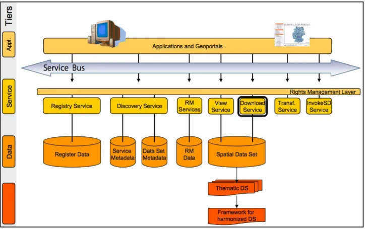
European communities, 2004). The figure 2 gives a summary of the INSPIRE Network Services
Architecture and at the core of the architecture are the INSPIRE Service Types (INSPIRE, 2009):
• Download, • View, • Discovery, • Transform, and • Invoke.
metadata content along with functionalities such as navigate, zoom in and out, pan and display.
INSPIRE Discovery Service makes it possible to search for spatial datasets and its contents based
on its metadata content. INSPIRE Transform Service enables spatial datasets to be transformed
which can then be viewed to achieve interoperability. INSPIRE Invoke Service allows to define the
input data and output data from the spatial service and provides a workflow with multiple services.
INSPIRE is selecting a download service candidate for meteorological data. Considering the tests
and data specifications it may be WFS or FTP. The main focus of this thesis is to suggest a suitable
candidate for INSPIRE Download Service to access meteorological data. INSPIRE Download
Services are implemented by ISO and OGC standards ( INSPIRE, 2009). While OGC is an
international organization and works have been carried out in every part of the world, the european
community have developed an initiative INSPIRE, which connects all the european union member
states to address major issue of spatial data harmonization to achieve web service interoperability.
Figure 2: INSPIRE service types (INSPIRE, 2008)
INSPIRE Download Service allows the user to download and have access to a set of geospatial data
or to a part of them. The INSPIRE Directive asks Member States to establish and operate a
downloaded and, where practicable, accessed directly (INSPIRE, 2008). A download service
supports (INSPIRE, 2008):
• download of a complete data set or data sets, or
• a part of a data set or data sets, and
• where, practicable, provides direct access to complete data sets or parts of data sets.
• Gazetteer like services are also covered by a type of download service.
The ability to access and use and reuse geographic information across Europe and across INSPIRE
Annex I-III themes is probably the most important concrete achievement of the INSPIRE program.
Download services are the mechanisms by which users can have access to the full information
content captured and transformed by member state into their geographic data sets according to the
INSPIRE defined themes (INSPIRE, 2009). The download services provide the capability to access
the information to fulfill a series of possible tasks including visualizing information in a variety of
ways, integration with other information, and to allow deep analysis as a basis for knowledge and
decision making.
An INSPIRE Download Service is a web service that provides access to the full extent of
geographic and thematic information in data sets belonging to the themes covered by the INSPIRE
Directive Annexes (INSPIRE, 2009). The INSPIRE Directive asks Member States in article 11(1)
(c) to establish and operate a network of “download services, enabling copies of spatial data sets, or
parts of such sets, to be downloaded and, where practicable, accessed directly”. A key INSPIRE
requirement is to implement web service across its member states to Download predefined datasets
or parts of predefined datasets (INSPIRE, 2009). According to the drafts of INSPIRE Download
Service there are 3 main criteria which are performance, availability and capacity. The three criteria
with the descriptions are given below (Ostensen, 2009):
• Performance: Performance, for Get Spatial Objects: initial response 30 s, then > 0.5 MB/s or
500 spatial objects/s
• Availability: service up by 99% of the time, no more 15 min downtime per day during
working hours
INSPIRE Download Service could be WFS, WCS, SOS or FTP download service which would be
selected. INSPIRE drafting team has specified some mandatory functionalities for INSPIRE
Download Service candidate. As explained by (Serrano, 2009), it has five main functionalities
which has been explained with description in table 1 below. It explains the each function which a
download service should perform along with its description.
Function Description
Get Download Service Metadata Provides information about the service
Get Spatial Objects Retrieves all spatial objects (based on query if direct access)
Describe Spatial Object Types Provides the description of spatial object types
Define Query Defines the query to be used in the Get Spatial Objects operation
Link Download Service Allows the declaration of the Download Service
Table 1: Technical overview of INSPIRE Download Service with description (Serrano, 2009).
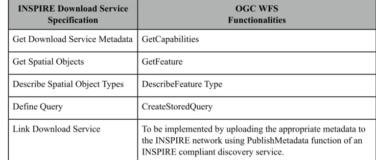
These main functions are for predefined datasets or predefined parts of data sets to be accessed
through the download service. Ostensen (2009), showed the similarity between the functions of
INSPIRE Download Service to OGC WFS 2.0. This has been shown in table 2, where the functions
of INSPIRE Download Service has been defined similar to OGC WFS with the description.
INSPIRE Download Service Specification
OGC WFS Functionalities
Get Download Service Metadata GetCapabilities
Get Spatial Objects GetFeature
Describe Spatial Object Types DescribeFeature Type
Define Query CreateStoredQuery
Link Download Service To be implemented by uploading the appropriate metadata to the INSPIRE network using PublishMetadata function of an INSPIRE compliant discovery service.
Table 2: Similarity between OGC WFS and INSPIRE Download Service functionalities (Ostensen,
2.4 Meteorological Data
The ability to easily exchange atmospheric, meteorological and climatological information in a
timely and useful fashion is becoming increasingly important. Data harmonization in the climate
sciences is an increasingly important strategy to achieve web service interoperability. Whether for
data assimilation, verification studies or model inter comparison projects, there is a growing need to
access and integrate a range of data from multiple sources (Woolf et al, 2005). Achieving
harmonization across these dimensions requires agreements on metadata formats, data access
service interfaces, and dataset content models. Recent developments in standards for geographic
information offer considerable potential for discovery and exchange of earth-related information
(Woolf et. al, 2004).
Climate Science Modeling Language (CSML)
Environmental scientists use highly diverse sources of data, including in situ measurements,
remotely sensed information and the results of numerical simulations (Reading e-Science Center,
2009). Scientific investigation is based mainly on accessing, visualizing and combining the datasets
but it is more difficult than it seems as these datasets can be represented in many different ways.
Due to this most of the environmental data is unused. The Climate Science Modeling Language
(CSML) addresses this problem by defining a standard way to represent environmental datasets.
CSML is a standards-based data model and GML application schema for atmospheric and
oceanographic data with associated software tools developed at theRutherford Appleton Laboratory
(Didcot, UK). This work is being performed as part of the Natural Environment Research Council
(NERC) C-SEKT project (CSML-Strategic Exploration and Knowledge Transfer) project 1.This
CSML model tries to encapsulate or wrap climate science data with its semantics generically. It
provides a semantic model to represent a wide range of data which is important to Climate science.
CSML was developed as part of the framework (ISO TC211 standards) of geographic information
models. CSML is an instance of GML application schema. One of the key concepts in CSML is that
of the ‘Feature’ as defined in the ISO TC211 ‘Domain Reference Model’ (ISO, 2002). This standard
establishes a ‘framework for standardization in the field of geographic information and sets forth
the basic principles by which this standardization takes place’ (ISO, 2002).
CSML has been designed explicitly with a dual purpose. Besides modeling various climate science
1(http//ndg.badc.rl.ac.uk/csml/)
data types, it provides a mechanism for wrapping and aggregating file-based data storage (e.g.
NetCDF, GRIB Ames formats) to provide a uniform semantic interface to climate science data. The
key subcomponents of CSML as shown by (NERC, 2009):
• Feature Type Definitions: A set of UML conceptual models ('feature types') for a range of
atmospheric and oceanographic data types relevant to key NDG Data Providers, based on the
framework and components provided by ISO standards for geospatial information modeling.
• CSML itself (an application schema of GML), built around these feature types providing a
standards-based reference encoding for NDG datasets.
• CSML Tools: CSML scanner to facilitate the production of CSML markup for some existing
data file formats and CSML parser to demarshall a CSML document into corresponding
object instances.
• CSML Services: COWS (Ceda OGC Web Service) framework-data described by GML
application schema. Data stored as CSML storage descriptor.
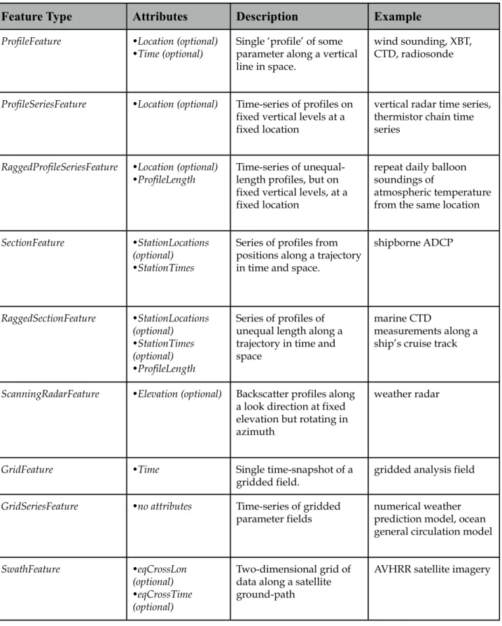
Currently, CSML has thirteen features along with its attributes. Table 3 below gives a detailed
explanation about the thirteen CSML features along with their attributes, description and example.
Feature Type Attributes Description Example
PointFeature •Location •Time (optional)
Single point measurement Rain gauge
PointSeriesFeature •Location Time-series of single datum measurements at a fixed location in space.
Tide gauge, Rainfall time series
TrajectoryFeature •No attributes but is associated coverage is defined over a Trajectory Domain
Measurement along a discrete path in time and space.
Surface salinity along a ship’s cruise track; atmospheric aerosols along an aircraft’s flight path
PointCollectionFeature •Time (optional) Collection of distributed single datum
measurements at a particular time
Feature Type Attributes Description Example
ProfileFeature •Location (optional) •Time (optional)
Single ‘profile’ of some parameter along a vertical line in space.
wind sounding, XBT, CTD, radiosonde
ProfileSeriesFeature •Location (optional) Time-series of profiles on fixed vertical levels at a fixed location
vertical radar time series, thermistor chain time series
RaggedProfileSeriesFeature •Location (optional) •ProfileLength
Time-series of unequal-length profiles, but on fixed vertical levels, at a fixed location
repeat daily balloon soundings of
atmospheric temperature from the same location
SectionFeature •StationLocations (optional)
•StationTimes
Series of profiles from positions along a trajectory in time and space.
shipborne ADCP RaggedSectionFeature •StationLocations (optional) •StationTimes (optional) •ProfileLength
Series of profiles of unequal length along a trajectory in time and space
marine CTD
measurements along a ship’s cruise track
ScanningRadarFeature •Elevation (optional) Backscatter profiles along a look direction at fixed elevation but rotating in azimuth
weather radar
GridFeature •Time Single time-snapshot of a
gridded field.
gridded analysis field
GridSeriesFeature •no attributes Time-series of gridded parameter fields
numerical weather prediction model, ocean general circulation model
SwathFeature •eqCrossLon (optional) •eqCrossTime (optional)
Two-dimensional grid of data along a satellite ground-path
AVHRR satellite imagery
Table 3: CSML Features and their descriptions (CSML, 2010).
BUFR Data
BUFR format (Binary Universal Form of Representation of meteorological data) is in fact a very
general format which could support any type of data assuming we could get the corresponding
(WMO) standard binary code for the representation and exchange of observational data
(EUMETSAT, 2009). A BUFR message is also defined as a sequence of sections which comprises
of:
•Start of message,
•A product definition section indicating mainly originating centre, date and time,
•A data definition section,
•The data as defined by the previous section, and
•End of message.
BUFR files contain a large amount of information. It has 255 data codes which is explained in table
2 below and different data formats in which these data are represented for various communities.
SYNOP (surface observations), TEMP (upper air soundings), METAR (Aviation weather data) and
CLIMAT (monthly climatological data) (WMO, 2009) are some of the BUFR formats commonly in
use. BUFR was designed to be portable, compact, and universal. In the WMO terminology (WMO,
2009), BUFR belongs to the category of table-driven code forms, where the meaning of data
elements is determined by referring to a set of tables that are kept and maintained separately from
the message itself.
The SYNOP message format is been used for real time transmission of synoptic weather
observations over the years. At present it is used by more than 200 met office or auxiliary stations in
United Kingdom which takes observations hourly, 3-hours, 6-hours or irregular intervals (BADC,
2010). A SYNOP format can contain information like mean sea level pressure, air temperature, dew
point, wind speed, wind direction, visibility, cloud type and direction. The METAR message format
for synoptic observations are mainly used for Aviation purposes and these observations taken in
hourly basis. METAR format is mainly used by aviation community. METAR formats contains
informations which are useful for aviation like altimeter pressure, wind speed, wind direction,
visibility, runaway visual range, cloud type and amount (BADC, 2010).
The table 4 below gives an overall data codes used in BUFR for various communities. These codes
are categorized based on its data collected and these codes can be in any formats such as synoptic
features (code 7) can be in SYNOP format or METAR format based on the community using it. For
CODE Meaning
0 Surface data - Land
1 Surface data - Sea
2 Vertical Soundings (other than satellite)
3 Vertical Soundings (satellite)
4 Single level upper-air data (other than satellite)
5 Single level upper-air data (satellite)
6 Radar Data
7 Synoptic features
8 Physical/Chemical constituents
9 Dispersal and Transport
10 Radiological data
11 BUFR tables, complete replacement or update
12 Surface data (satellite)
13 Forecasts
14 Warnings
15-19 Reserved
20 Status information
21 Radiances (satellite measured)
22 (Awaiting validation) Radar (satellite) but not altimeter
and scatterometer
23 (Awaiting validation) Lidar (satellite)
24 (Awaiting validation) Scatterometry (satellite)
25 (Awaiting validation) Alimetry (satellite)
26 (Awaiting validation) Spectrometry (satellite)
27 (Awaiting validation) Gravity measurement (satellite)
28 (Awaiting validation) Precision orbit (satellite)
CODE Meaning
30 (Awaiting validation) Calibration datasets (satellite)
31 Oceanographic data
32-100 Reserved
101 Image data (satellite)
102-239 Reserved
240-254 For experimental use
255 (BUFR edition 3) Indicator for local use, with sub category
255 (BUFR edition 4) Other category
3. METHODOLOGY AND CONCEPTUAL MAPPING
To access meteorological data and to achieve the objectives of this thesis (section 1.4), a conceptual
methodology is adopted. This chapter is divided into two main sections: methodology for accessing
meteorological data and conceptual mapping from BUFR to CSML.
3.1
Methodology for Accessing Meteorological Data
The proposed methodology for this thesis is shown in Figure 3 which gives an overall idea about
the methodology that would be followed to achieve the objectives.
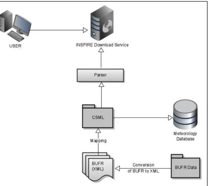
Figure 3: This figure shows the proposed methodology that will be followed for this thesis.
The boxes are the input material (BUFR data) and the texts in between the arrows (conversion of
softwares available. The arrows are pointed in the direction of achieving the output. BUFR is
converted to BUFR XML using software and then mapping is done from BUFR XML to CSML
(see section 2.5.1). Later a parser is used to access mapped CSML data. INSPIRE Download
Service would be selected based on the draft guidelines given by INSPIRE and will then be used to
access the mapped CSML file.
Suitable meteorological data will be selected for the implementation of the project. BUFR files
which are quite complex and can store a lot of information would be selected for analysis. We select
SYNOP and METAR formats as representative BUFR formats. SYNOP is commonly used for
surface observations and METAR is used in aviation weather data. These two BUFR formats are
widely used and contain lot of information, so we chose SYNOP and METAR formats as test data.
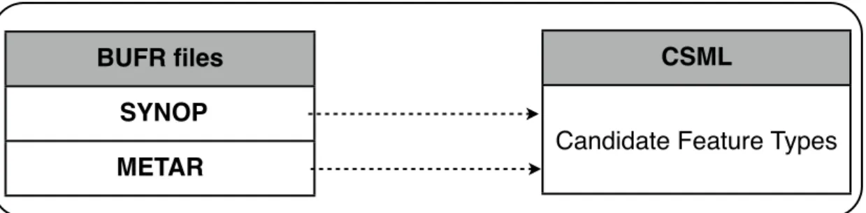
3.2 Conceptual Mapping from BUFR to CSML
This section deals with the conceptual mapping between the BUFR XML output files and the
CSML Features. CSML has thirteen features with each feature having attributes which are
explained in detail in table 1 of chapter 2. The XML output file attributes will be mapped according
to the relevance to the attributes in the CSML features. These mappings will be used for writing the
code for CSML parser to access the BUFR files. Figure 4 shows the mapping between BUFR and
CSML.
CSML
Candidate Feature Types
BUFR files
SYNOP
METAR
Figure 4: BUFR XML to CSML mapping.
SYNOP
SYNOP data formats are mainly used for surface observations data. The SYNOP data are converted
into XML output files and each SYNOP data subset is converted into single XML file with the
software. After converting the SYNOP data format there were twenty-six subset SYNOP files. The
subsets are given in the annex. Table 5 shows all the SYNOP attributes from the output files along
SYNOP (26 subsets) Attributes Description of the attributes
Latitude Position of the instrument
Longitude Position of the instrument
Height Height of the instrument
Visibility (horizontal) Visibility of the pilot in the manned instrument or station
Precipitation It is the product of the condensation of atmospheric
water vapor that is pulled down by gravity and
deposited on the Earth's surface
Cloud (type, cover,distribution, direction) Mass of droplets suspended in atmosphere
Temperature (max & min) Temperature range over a period of time
Humidity Amount of water vapor in the air
Pressure (3/24 hr pressure change) Force per unit area exerted against a surface by the
weight of air above that surface at any given point in
the earth’s atmosphere
Station (Type, name, height) Facility for observing atmospheric conditions to provide weather forecast information
Geopotential height Geopotential height is a Vertical coordinate
referenced to Earth's mean sea level.
Sensor height Height of the sensor
Evaporation Vaporization of a liquid
Vertical sounding significance (bearing or azimuth & elevation)
Vertical sounding other than aircraft like radar
Radiation Long and short wave radiation, global, net &
diffuse solar radiation in a time period
Table 5: SYNOP attributes obtained after conversion into XML output along with their descriptions.
METAR
METAR is mainly used for aviation weather data. Similarly, METAR data are converted into XML
output files and each METAR data subset is converted into single XML file with the software.
METAR has five subsets after converted into XML output. Table 6 shows all the attributes of the
METAR (5 subsets) Attributes Description of the attributes
Latitude Position of the instrument
Longitude Position of the instrument
Height Height of the instrument
Extended degree of turbulence Disturbance due to icing layer in the cloud
Flight level Ascent or descent profile data of the flight
Cloud (type, distribution, direction) Mass of droplets suspended in atmosphere
Wind speed Speed at which the wind is traveling
Air frame icing Super cooled water in the cloud
Speed of motion of feature Speed of motion of the cloud system to predict thunderstorms
Vertical sounding significance Height of top of the cloud
First order statistics Statistical value relating to the data like max, minimum and means
Direction of motion of feature Direction of the cloud system
Table 6: METAR attributes obtained after conversion into XML output along with their descriptions.
Mapping Rules
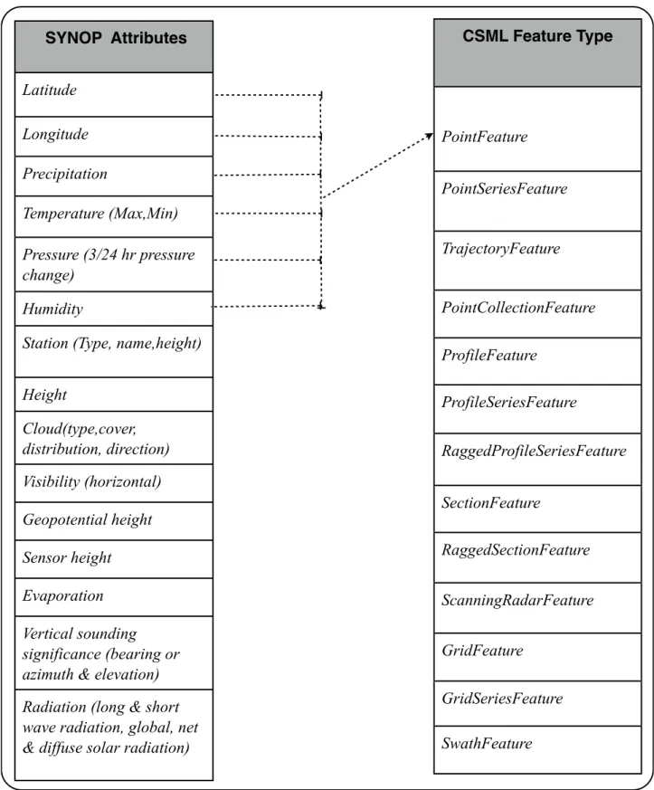
The mapping between SYNOP XML model and the CSML features is given in table 7. On the left
hand side are the SYNOP features and the arrow from the attributes of SYNOP features shows the
mapping towards the right hand side which is the CSML feature type. The single SYNOP XML
model contains a set of measurements at a particular station (particular latitude, longitude) taken at
a single time. So at that particular time and place there are measurements or averaged values for
of attributes are based on ‘where’ and ‘when’ is being measured rather than ‘what’ is being
measured. It is the sampling regime (shape) of the data that determines the CSML feature type not
what is being measured.
CSML Feature Type
PointFeature
PointSeriesFeature
TrajectoryFeature
PointCollectionFeature
ProfileFeature
ProfileSeriesFeature
RaggedProfileSeriesFeature
SectionFeature
RaggedSectionFeature
ScanningRadarFeature
GridFeature
GridSeriesFeature
SwathFeature
SYNOP Attributes
Latitude
Longitude
Precipitation
Temperature (Max,Min)
Pressure (3/24 hr pressure change)
Humidity
Station (Type, name,height)
Height
Cloud(type,cover, distribution, direction) Visibility (horizontal)
Geopotential height
Sensor height
Evaporation
Vertical sounding significance (bearing or azimuth & elevation) Radiation (long & short wave radiation, global, net & diffuse solar radiation)
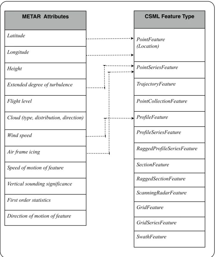
The METAR file has 5 attributes which could be mapped to CSML Features which has been shown
in table 8.
METAR Attributes
Latitude
Longitude
Height
Extended degree of turbulence
Flight level
Cloud (type, distribution, direction)
Wind speed
Air frame icing
Speed of motion of feature
Vertical sounding significance
First order statistics
Direction of motion of feature
CSML Feature Type
PointFeature (Location)
PointSeriesFeature
TrajectoryFeature
PointCollectionFeature
ProfileFeature
ProfileSeriesFeature
RaggedProfileSeriesFeature
SectionFeature
RaggedSectionFeature
ScanningRadarFeature
GridFeature
GridSeriesFeature
SwathFeature
Table 8 : Potential mapping between METAR XML attributes to CSML feature types.
PointFeature with attribute Location. Wind speed is measured at different values of height but at a given location. Thus Wind speed could be mapped to ProfileFeature. Wind speed can be also mapped to ProfileSeriesFeature if same set of heights are measured repeatedly. Extended degree of turbulence is measured at a single location with different values at a given height. So we can map
Extended degree of turbulence to PointSeriesFeature of CSML. Similarly Air frame icing is measured as a single location with different values at fixed height. Thus Air frame icing can also be mapped to PointSeriesFeature of CSML features.
These mappings are not direct one to one mappings. The mapping depends on ‘where’ and ‘when’ is
being measure rather than ‘what’ is being measured. For example, we cannot always map attribute
‘Temperature’ to ‘PointFeature’ as temperature can be measured in a series of points and so can also be mapped as ‘PointSeriesFeature’. Also ‘Wind Speed’ can be mapped to ‘ProfileSeriesFeature’ instead of ‘ProfileFeature’ if ‘Wind Speed’ is measured repeatedly at same set of height instead measuring at various heights. These mappings will be mapped into CSML
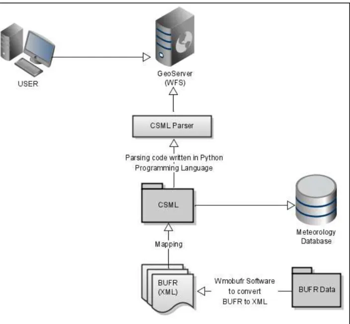
4. IMPLEMENTATION
This chapter gives an summary of all the implementations carried out to achieve the proposed
objectives for this thesis. We have used open source software for this implementation process such
as Wmobufr, NetBeans and OGC web services implemented WFS (GeoServer). All the softwares
are explained in detail below according to the workflow methodology. The figure 5 shows the
implementation architecture which gives an summary of the implementation carried out from the
proposed methodology in detail.
Figure 5: The implementation architecture.
The selected meteorological dataset (BUFR) will be converted into XML file format using
mapped to CSML features according to the relevance. Python2 which is a programing language like
Java3 will be used to write the CSML Parser code to access the mapping files from XML to CSML.
The meteorological dataset which is parsed by CSML using Python will be accessed using OGC
compliant web services. GeoServer 2.0 is OGC compliant web service that has complex feature
support in its new version which will be used to access the Meteorological data through WFS.
Considering the functioning of OGC WFS service to access the meteorological data, analysis will
be done to know the relation between OGC services and suggest INSPIRE Download Service for
meteorological data. In detail summary of the implementation is explained below.
4.1 Conversion of Meteorological Data (BUFR) to XML
For this experiment synoptic features (WMO code 7) and surface data-land (WMO code 0)
category data described in table 2 of chapter 2 was used as test data. These both data sets are in .bin
format. BUFR data are hard to find or to get access in the required format (SYNOP & METAR).
IBL Soft is a company which provides data processing solutions for meteorological customers.
National Oceanic and Atmospheric Administration (NOAA) is an american agency which works on
environmental researches. BUFR samples were provided by NOAA and IBL Soft (Bratislava) in the
required format (SYNOP and METAR) which is also suitable for this thesis.
As BUFR files are huge and contain lots of information, it was converted to XML file format which
would make it easy to access the information. The BUFR files were converted into XML files using
the open source tool Wmobufr. Brief description about Wmobufr is given below.
Wmobufr
Wmobufr4 is an open source Java package for translating WMO BUFR files into XML. The
Wmobufr package offers both a Java Application Programming Interface (API) for reading BUFR
files and a command-line utility to translate BUFR files into XML. The WMO BUFR format is
widely used for observational weather data. The format uses about 750 tables to encode
observations into bit strings. The tables and format are specified in standards published by the
WMO, the World Meteorological Organization. The Wmobufr package includes the WMO version
13 BUFR tables. The Wmobufr to XML translator 1.4.1 has the following features:
2
http://www.python.org/. Last Accessed 19 December 2009
3
http://www.java.com/en/. Last accessed 19 December 2009
4
• Is much faster and handles multiple input files.
• Handles BUFR editions 2, 3, and 4.
• Handles BUFR compression and has optional data validation.
• Has print, XML output content controls and provides multiple print output files.
NetBeans
NetBeans5 refers to both a platform for the development of applications for the network (using java,
Javascript, PHP, Python, Ruby, Groovy, C, and C++) and an integrated development environment
(IDE) developed using the NetBeans Platform. NetBeans IDE 6.8 was used to run the Wmobufr
software which converts the BUFR input files to XML output files.
The Wmobufr version 1.4.1 creates one XML output file per subset. After running the Wmobufr
source code on NetBeans, the NOAA file (METAR) after conversion had 5 subsets and the IBL Soft
(SYNOP) had 26 subsets in XML output. The Wmobufr source code run on NetBeans is shown in
figure 6 with all the packages of Wmobufr.
Figure 6: This shows the Wmobufr package files on NetBeans 6.8 used to convert BUFR to XML.
5
The XML files which was got by Wmobufr software run on NetBeans will be now analyzed for
attributes present and mapped based on the relevance to the available 13 CSML features.
4.2 Mapping of BUFR XML to CSML Features using CF Convention
The XML output files were analyzed for the attributes and potential mapping were done based on
the CSML features and their relating attributes. The mapping has been explained in chapter 3. Each
subset in the SYNOP file is from a different location and station name (Latitude & Longitude) and
has attributes like temperature, pressure, visibility and precipitation. A single SYNOP file has attributes like temperature, Pressure, Dew point Temperature related to CSML pointFeatures.
Mapping’s from BUFR XML parameters to CSML was done based on The convention for Climate
and Forecast [CF convention]6. The CF convention defines metadata that provides a definitive
description of what the data in each variable represents along with the spatial and temporal
properties of the data. This facilitates users from various sources to decide which data are
comparable and facilitates building applications with powerful extraction, regridding and display
capabilities.
The compliance of the data with the CF-convention can also be checked online. This was developed
at the Hadley Centre for Climate Prediction and Research, United Kingdom Met Office by Rosalyn
Hatcher and CF-checker has now been taken over by the NCAS-CMS (National Centre for
Atmospheric Science - Computational Modeling Support). This is only available for NetCDF files
where, NetCDF mapping files can be checked with CF convention. This can be checked against
version 1.0, 1.1, 1.3 and 1.4 of the CF-conventions7.
One random SYNOP subset file was selected for analyzing the mapping to CSML PointFeatures.
The mapping was done manually (by hand) analyzing the attributes of BUFR XML parameters with
the features of CSML using the CF convention. Similarly mapping can also be done for each
SYNOP subset with the related attributes. SYNOP subset 10 and METAR subset 4 was selected and
the mappings from BUFR XML (SYNOP subset 10) to CSML is given in the Annex 1, 2 and 3.
6
http://cf-pcmdi.llnl.gov/documents/cf-standard-names/standard-name-table/12/cf-standard-name-table.html. Last Accessed 15 December 2009.
7
4.3 CSML Parser to Access XML Features
The CSML parser is a conventional parser which can read CSML files. It is encoded as XML and
also determines the structure and properties of the data it contains. The CSML parser is written in
Python programming language and this parser creates Python objects representing the contents of
the CSML file. These CSML files can be accessed through web services which can be configured to
the required dataset or use a higher level CSML API that provides a more intuitive interface. The
CSML mapped file can be stored in a database or in the system to be accessed by the CSML parser
given the exact location.
There is also an online parser available at the CSML website8, allowing CSML files to be tested
against the parser. This online parser is a simple web interface to the parser and allows the user to
parse a CSML document. It is not a true CSML validator but it shows how the parser reads the input
CSML file. The input and output files have to be similar and if they differ then its wrong or
something is not parsed. This could arise if an invalid CSML document is used or there is some bug
in the system or some elements which are not fully implemented in the online parser. This is a good
way to verify the CSML file and check if it can be parsed using the online parser. Online CSML
parser was not used for this thesis as we did not automate the process and used CSML mapping file
which was mapped by hand. Figure 7 shows the online parser screenshot taken from the CSML
website.
Figure 7: This shows the Online parser screenshot available at the CSML website (CSML, 2010).
8
The BUFR SYNOP (subset 10) was mapped to CSML features based on the mapping regime and
CF convention. The mapping was done manually (by hand) analyzing the attributes with the
features of CSML. As this is a prototype implementation, we will be storing the hand made CSML
mapping file in the system which can be accessed directly by GeoServer rather than parsing the
CSML file to automate the process.
4.4 Accessing CSML through OGC Web Services
GeoServer9 is an OGC compliant open source server which can be operated in most of the operating
systems. GeoServer 2.0 which can access complex features was installed to access CSML features.
GeoServer was installed with the local host in the University of Jaume I along with Tomcat10, which
is an application server and Apache, a web server. GeoServer 2.0 which is the latest version has
default features which would allow users to access the complex features stored in a database by
configuring the GeoServer to the required attributes in the CSML mapped file.
The application schema support extension provides support for complex features in GeoServer WFS. It was installed manually to access the complex feature CSML manually mapped file. The app-schema module takes one or more of these simple feature data stores and applies a mapping to convert the simple feature types into one or more complex feature types conforming to a GML application schema (GeoServer, 2010). Figure 8 shows how the tables in a database are accessed in GeoServer which are converted into complex features.
Figure 8: This figure shows the three tables in a database are accessed using GeoServer simple feature support and converted into two complex feature types (GeoServer, 2010).
9
http://blog.geoserver.org/2009/10/26/geoserver-2-0-released/. Last Accessed 24 February 2010.
10
WFS, implemented on GeoServer could in principle access CSML, which is an GML application
schema. This has not been tested yet but in this thesis we tried to access the CSML mapped file with
the WFS implemented on GeoServer but got some errors. Due to time constraints, we decided to
continue the research on configuring GeoServer as future work where the complexity of the CSML
structure would be studied and then try to configure the GeoServer to the CSML mapping file and
later access it through WFS implemented on GeoServer.
4.5 INSPIRE Download Service for Meteorological Data
INSPIRE is in the process of selecting a candidate for INSPIRE Download Service to access
meteorological data. As discussed earlier (section 2.3), the specifications and functionalities for
INSPIRE Download Service are similar to the OGC specifications for WFS 2.0. The similarity
between OGC WFS 2.0, which is under way along with WCS and INSPIRE Download Service will
be discussed in detail in chapter 5. The idea of this thesis is to investigate OGC WFS and also look