Advances in Geosciences, 2, 217–220, 2005 SRef-ID: 1680-7359/adgeo/2005-2-217 European Geosciences Union
© 2005 Author(s). This work is licensed under a Creative Commons License.
Advances in
Geosciences
Genesis and maintenance of “Mediterranean hurricanes”
K. Emanuel
Program in Atmospheres, Oceans, and Climate, Massachusetts Institute of Technology, Cambridge, Massachusetts, USA Received: 24 October 2004 – Revised: 21 May 2005 – Accepted: 6 June 2005 – Published: 27 June 2005
Abstract. Cyclonic storms that closely resemble tropi-cal cyclones in satellite images occasionally form over the Mediterranean Sea. Synoptic and mesoscale analyses of such storms show small, warm-core structure and surface winds sometimes exceeding 25 ms−1over small areas. These
anal-yses, together with numerical simulations, reveal that in their mature stages, such storms intensify and are maintained by a feedback between surface enthalpy fluxes and wind, and as such are isomorphic with tropical cyclones. In this paper, I demonstrate that a cold, upper low over the Mediterranean can produce strong cyclogenesis in an axisymmetric model, thereby showing that baroclinic instability is not necessary during the mature stages of Mediterranean hurricanes.
1 Introduction
The Mediterranean Sea is a favored location for the develop-ment of cyclonic storms (Petterssen, 1956). Most of these are of synoptic scale and baroclinic in origin, sometimes aided by the peculiar nature of flow around the Alps and Pyre-nees (Buzzi and Tibaldi, 1978). But once in awhile, intense mesoscale vortices develop whose structure, as revealed by satellite images, closely resembles tropical cyclones, having a clear, circular eye surrounded by an eyewall and a roughly axisymmetric cloud pattern (Mayengon, 1984). Experiments with full-physics, three-dimensional models (Pytharoulis et al., 2000) demonstrate that, at least in their mature phase, such storms are maintained the same way as tropical cy-clones, by inducing large enthalpy fluxes from the sea.
In this paper, I review one well-observed Mediterranean hurricane, and model its development using a nonhydro-static, axisymmetric, convection-resolving model, to show that standard baroclinic processes need not be called on to explain the final development, though they are probably
nec-Correspondence to:K. Emanuel (emanuel@texmex.mit.edu)
essary in the early stages. I conclude with a brief theoretical treatment of the problem.
2 An example
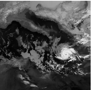
A well-studied example of a Mediterranean hurricane oc-curred in mid January, 1995. As shown in Fig. 1, this storm looks very much like a small hurricane in satellite images. It developed directly underneath an unusually deep, cut-off low at upper levels, and on the west side of a larger-scale surface cyclone (Fig. 2). Mediterranean hurricanes usually, and per-haps always, develop under deep upper tropospheric troughs, in regions of small baroclinicity but large air-sea thermody-namic disequilibrium owing to the unusually deep, cold air associated with the trough. (This is also true of “polar lows”; Rasmussen et al., 1992.) Soundings near the surface cyclone reveal very large instability to ascent of surface air saturated at sea surface temperature (Pytharoulis et al., 2000), a mea-sure of potential intensity (Bister and Emanuel, 2002). At the same time, the air is nearly saturated through a deep layer, owing to its having been lifted (and thereby cooled) on the approach of the upper low, as dictated by inversion of the upper potential vorticity anomaly (Hoskins and Robertson, 1985). As we shall see in the next section, the atmosphere over the relatively warm Mediterranean and under a deep, cutoff cold low is an ideal embryo in which to gestate a hur-ricane.
3 A numerical simulation
218 K. Emanuel: Genesis and maintenance of “Mediterranean hurricanes”
Fig. 1.Mediterranean Hurricane on 15 January 1995.
(WISHE), since baroclinic instability is absent in axisym-metric geometry. I run the model with a radial grid size of 3.75 km and vertical level separation of 300 m. The model is initialized with an ambient sounding characteristic of radia-tive equilibrium over a sea surface of temperature 24◦
C, but in this integration the sea surface temperature is reduced to 22◦
C. (The sounding as produced by running the same model into a state of convective neutrality, as described in Rotunno and Emanuel, 1987.) This has the effect of greatly reducing the potential intensity, to reflect the low climatological po-tential intensity over the Mediterranean in January. Into this state I insert an upper cold low with maximum wind ampli-tude at 10 km altiampli-tude, decaying linearly to zero at the surface and also decaying upward into the stratosphere. The maxi-mum wind of 20 ms−1of this initial cold low is at a radius
of 300 km; thermal wind balance then gives a minimum tem-perature perturbation of−4◦C at about 9 km altitude. Near
the center of this initial cold upper low, there is considerable potential intensity. The initial wind and pressure fields are in gradient and hydrostatic balance. Small perturbations are introduced into the surface fluxes to initiate convection and development.
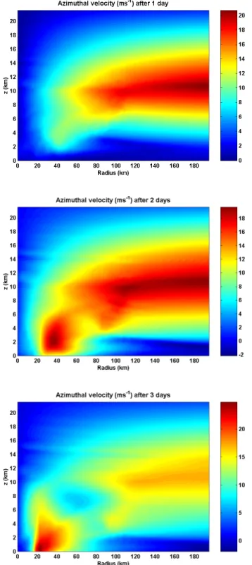
Figure 3 shows the evolution of the azimuthal wind com-ponent with time. After two days, a shallow, low-level, warm-core cyclone has developed and by the third day has maximum winds of about 24 ms−1 at a radius of around
20 km. If allowed to persist for several more days, this storm extends upward and develops to hurricane strength (∼35 ms−1), and in large measure destroys the upper cold
low in the process. This development proceeds somewhat faster than most tropical cyclones do, owing to its small scale and the relatively large value of the Coriolis parameter.
Fig. 2.500 hPa geopotential height (dm, top) and sea level pressure (hPa, bottom), at 00:00 GMT on 15 January 1995. Analyses from NCAR/NCEP 2.5 degree re-analysis data.
There is increasing evidence that real tropical cyclones also develop inside cold core cyclones, though these are mesoscale features that arise in association with mesoscale convective complexes (Bister and Emanuel, 1997). The cy-clonic vorticity together with the downdraft-suppressing hu-midified air is highly conducive to tropical cyclogenesis. The simulations described here show that the moist, cold air found underneath deep upper cold lows over warm seas, such as the Mediterranean, are likewise nearly ideal incubators for hurricane-like developments.
4 Theory of cyclone development under upper cold lows
Consider first a horizontally homogeneous atmosphere over-lying an ocean surface of constant temperature in a state of radiative-moist convective equilibrium. I will approximate the temperature lapse rate in the troposphere as moist adia-batic, having a constant value of the saturation moist static energy,h∗
, defined
K. Emanuel: Genesis and maintenance of “Mediterranean hurricanes” 219
Fig. 3. Azimuthal velocity (ms−1) in the axisymmetric, nonhy-drostatic model, after 1 day (top), 2 days (middle), and three days (bottom) of integration.
wherecp is the heat capacity at constant pressure,T is the absolute temperature,gis the acceleration of gravity,zis the altitude,Lvis the latent heat of vaporization, andq∗is the saturation specific humidity. Then the potential maximum
Fig. 4. Potential maximum wind speed (ms−1)over the Mediter-ranean Sea at 12:00 GMT on 5 October 2004, from the NCEP anal-ysis on a 1 degree grid.
wind speed squared is given by (Bister and Emanuel, 1998) : Vp2= Ck
CD
Ts−To To
h∗
s −h
∗
, (2)
whereCk andCD are the surface exchange coefficients for enthalpy and momentum,Ts andToare the sea surface and entropy-weighted outflow temperatures, andh∗
s is the satura-tion moist static energy of air at sea level at sea surface tem-perature. Usually, over the Mediterranean,Vp is too small to support tropical cyclones, but it can be large in the fall (Fig. 4). Moreover, the air over the Mediterranean is usually far too dry to allow tropical cyclones to develop.
Now suppose a synoptic scale, upper cold low is advected into this environment. As the low approaches, the air mass is lifted, decreasing the temperature aloft and increasing con-vective instability. I shall suppose that convection occurs and holds the lapse rate at a moist adiabatic value. Hydrostatic equilibrium gives
∂φ
∂p
′
= −α′ = −
∂α
∂h∗
′h∗′ = −
∂
lnT ∂p
h∗ h∗′,
(3) where φ is the geopotential, α is the specific volume, the primes represent departures from the background state along surfaces of constant pressure, and I have used one of Maxwell’s relations (Emanuel, 1986). I can now integrate this through the depth of the troposphere, to relate the pertur-bation ofh∗
at the center of the cold low to the perturbation ofφassociated with cold low at the tropopause:
h∗ ′ =φ
′
cl−φ
′
s
lnTs
To
≃
To φcl′ −φ
′
s
Ts−To
, (4)
220 K. Emanuel: Genesis and maintenance of “Mediterranean hurricanes” into (2), I obtain an expression for the modified potential
in-tensity at the core of the cold low aloft: Vmod2 =Vp2− Ck
CD
φ′cl−φs′ (5)
Sinceφ′will be more negative in a cold upper low than at the
surface underneath it, this will give an increase of potential intensity. Note that in evaluating (3), the ambient potential intensity,Vp2, may very well be negative if the atmosphere is stable to the lifting of a parcel saturated at sea surface tem-perature. Examining Fig. 2, I note that the center of the cut-off low aloft,φ′
cl≃−4000 m2s
−2, while in the synoptic-scale
surface low underneath,φ′
s≃−2500 m2s−2. Even if the am-bient potential intensity (i.e. in the absence of the cold low) is zero, this gives a maximum wind speed of around 40 ms−1,
assuming that the exchange coefficients are equal.
5 Conclusions
The climatological potential intensity over the Mediterranean Sea is usually only marginal for tropical cyclone formation, and the atmosphere is usually far too dry to permit develop-ment. But when a deep, upper-level cutoff low moves over the region, the air mass must ascend and cool to maintain balance. Thus the air under such an upper low is unusually cold and humid. Its low temperature, in combination with the relative warmth of the underlying sea, and its high rel-ative humidity provide an ideal incubator for hurricane-like development. A simulation with an axisymmetric, nonhy-drostatic, cloud-resolving model shows rapid development under these circumstances. Calculations of potential inten-sity over the Mediterranean using daily re-analysis data are underway; these should enable an assessment of the overall risk of hurricanes in the Mediterranean region.
Acknowledgements. The author is grateful for the support provided by the National Science Foundation, under grant ATM-0349957.
Edited by: L. Ferraris
Reviewed by: anonymous referees
References
Bister, M. and Emanuel, K. A.: The genesis of Hurricane Guillermo: TEXMEX analyses and a modelling study, Mon. Wea. Rev., 125, 2662–2682, 1997.
Bister, M. and Emanuel, K. A.: Dissipative heating and hurricane intensity, Meteor. Atmos. Physics, 50, 233–240, 1998.
Bister, M. and Emanuel, K. A.: Low frequency variabil-ity of tropical cyclone potential intensvariabil-ity, 1: Interannual to interdecadel variability, J. Geophys. Res., 107 (4801), doi:10.1029/2001JD000776, 2002.
Buzzi, A. and Tibaldi, S.: Cyclogenesis in the lee of the Alps: A case study, Quart. J. Roy. Meteor. Soc., 104, 271–287, 1978. Emanuel, K. A.: An air-sea interaction theory for tropical cyclones.
Part I., J. Atmos. Sci., 42, 1062–1071, 1986.
Hoskins, B. J., McIntyre, M. E., and Robertson, A. W.: On the use and significance of isentropic potential vorticity maps, Quart. J. Roy. Meteor. Soc., 111, 877–946, 1985.
Mayengon, R.: Warm core cyclones in the Mediterranean, Mariners Weather Log, 28, 6–9, 1984.
Petterssen, S.: Weather Analysis and Forecasting, 2nd McGraw-Hill, New York, 1956.
Pytharoulis, I., Craig, G. C., and Ballard, S. P.: The hurricane-like Mediterranean cyclone of January 1995, Meteorol. Appl., 7, 261–279, 2000.
Rasmussen, E. A., Pedersen, T. B., Pedersen, L. T., and Turner, J.: Polar lows and arctic instability lows in the Bear Island region, Tellus, 44A, 133–154, 1992.