www.nonlin-processes-geophys.net/15/275/2008/ © Author(s) 2008. This work is licensed
under a Creative Commons License.
in Geophysics
Combination of different types of ensembles for the adaptive
simulation of probabilistic flood forecasts: hindcasts for the Mulde
2002 extreme event
J. Dietrich1, S. Trepte2, Y. Wang1, A. H. Schumann1, F. Voß1,*, F. B. Hesser1,**, and M. Denhard2
1Institute of Hydrology, Water Resources Management and Environmental Engineering, Ruhr University Bochum, Bochum,
Germany
2Deutscher Wetterdienst DWD (German National Weather Service), Offenbach, Germany *now at: Center for Environmental Systems Research, University of Kassel, Kassel, Germany
**now at: Bundesanstalt f¨ur Wasserbau (Federal Waterways Engineering and Research Institute), Hamburg, Germany
Received: 24 August 2007 – Revised: 3 December 2007 – Accepted: 13 February 2008 – Published: 19 March 2008
Abstract.Flood forecasts are essential to issue reliable flood
warnings and to initiate flood control measures on time. The accuracy and the lead time of the predictions for head waters primarily depend on the meteorological forecasts. Ensemble forecasts are a means of framing the uncertainty of the po-tential future development of the hydro-meteorological situ-ation.
This contribution presents a flood management strategy based on probabilistic hydrological forecasts driven by op-erational meteorological ensemble prediction systems. The meteorological ensemble forecasts are transformed into dis-charge ensemble forecasts by a rainfall-runoff model. Ex-ceedance probabilities for critical discharge values and prob-abilistic maps of inundation areas can be computed and pre-sented to decision makers. These results can support decision makers in issuing flood alerts. The flood management system integrates ensemble forecasts with different spatial resolution and different lead times. The hydrological models are con-trolled in an adaptive way, mainly depending on the lead time of the forecast, the expected magnitude of the flood event and the availability of measured data.
The aforementioned flood forecast techniques have been applied to a case study. The Mulde River Basin (South-Eastern Germany, Czech Republic) has often been affected by severe flood events including local flash floods. Hind-casts for the large scale extreme flood in August 2002 have been computed using meteorological predictions from both the COSMO-LEPS ensemble prediction system and the de-terministic COSMO-DE local model. The temporal evolu-tion of a) the meteorological forecast uncertainty and b) the probability of exceeding flood alert levels is discussed. Re-sults from the hindcast simulations demonstrate, that the
sys-Correspondence to:J. Dietrich ([email protected])
tems would have predicted a high probability of an extreme flood event, if they would already have been operational in 2002. COSMO-LEPS showed a reasonably good perfor-mance within a lead time of 2 to 3 days. Some of the deter-ministic very short-range forecast initializations were able to predict the dynamics of the event, but others underpredicted rainfall. Thus a lagged average ensemble approach is sug-gested. The findings from the case study support the often proposed added value of ensemble forecasts and their proba-bilistic evaluation for flood management decisions.
1 Introduction
Uncertainties in flood forecasting mainly result from incom-plete knowledge of the further meteorological development and from uncertainties of hydrological and hydraulic mod-elling. Known and knowable sources of uncertainty are the availability and quality of input data, respectively initial and boundary conditions for the models, as well as model pa-rameters and model structure. Inaccurate human interaction and technical problems may also affect the output of a flood prediction chain. The highly nonlinear behaviour of the at-mospheric system and the land-atmosphere interaction adds unknowable sources of uncertainty. Thus a perfect weather forecast is impossible (Lorenz, 1963). Resulting from these uncertainties it is not possible to issue a perfect flood fore-cast.
Driving Force Global Prediction
Systems
Deterministic local model COSMO-DE: m=1, +21 h, 2.8 km COSMO-EU
Driving
Force Force
Driving Force
Meso-scale Ensemble Systems Ob ti Assimilation COSMO-DE Lagged
2002
Force
y COSMO-LEPS: m=16, +5 d, 10 km
SRNWP-PEPS: m=17, +2 d, 7 km
gg Average-Ensemble m=7, +21 h, 2.8 km Assimilation
Observations
radar, gauges 2006
2002 2005
Superensemble (m=19): PEPS (m=17), COSMO-LEPS (median), COSMO-DE
Observations radar, gauges Calibration, Bayesian
Model Average (BMA)
Assimilation
2007 Probabilistic weather scenario: reduced multi-model
ensemble, pdf, model average, m approx. 10
Fig. 1. Meteorological ensembles from different sources used for an ensemble-based operational flood risk management strategy. The number of ensemble members is denoted by m, the other values indicate the lead time and the horizontal spatial resolution of the ensemble prediction systems.
levels causing inundation) can be provided to flood managers and decision makers.
Ensemble techniques are suitable methods for producing probabilistic forecasts (Anderson, 1996; Kalnay, 2002; Toth et al., 2003). In the context of flood management, ensembles are a group of alternative scenarios of possible future de-velopment of the hydro-meteorological situation. Different types of ensembles can be classified according to the gener-ating mechanisms (for meteorological as well as for hydro-logical applications):
– single system ensembles: perturbation of initial and boundary conditions, different convection schemes (physically based ensembles), perturbation of model pa-rameters;
– multiple systems or multi-model ensembles (“poor man ensembles”): combination of simulations from different models (e.g. Georgakakos et al, 2004);
– lagged average ensembles: combination of current fore-casts with forefore-casts from earlier model runs (Hoffman and Kalnay, 1983).
Meteorological ensemble prediction systems (EPS) have be-come operational. Buizza et al. (2005) compare three global EPS. The development of hydrological applications of en-semble forecasts has started in the late 1990-ies and is sub-ject of ongoing research (e.g. de Roo et al., 2003; Mullusky et al., 2004; Gouweleeuw et al., 2005; Verbunt et al., 2006; Reed et al., 2007).
Beven and Binley (1992) published seminal work about uncertainty estimation in hydrological modelling. Most of the techniques applied in hydrologic modelling need hun-dreds or even thousands of model runs and often produce
a lot of information, which is not useful for decision ori-ented operational flood management. Ensemble techniques aiming at the representation of hydrological uncertainty with only a few (in the dimension of 10) members still have to be developed. Methods of combining the simulations of mul-tiple models are subject of current research (e.g. Bayesian Model Averaging, Hoeting et al., 1999; Raftery et. al., 2005; Sloughter et al., 2006). Recently Ajami et al. (2007) pre-sented a study about the computation and combination of hydrological multi-model ensembles to account for model structure uncertainty. They list relevant sources in this field. Interdisciplinary studies dealing with the probabilistic as-sessment of the flood forecast chain have been published e.g. by Krzysztofowicz (2002), Apel et al. (2004) and Pap-penberger et al. (2005).
The participatory HEPEX project (Hydrological Ensem-ble Prediction Experiment, Schaake et al., 2007) integrates meteorologists, hydrologists and users in order to promote the development of ensemble streamflow forecast systems. In Europe, the probabilistic Flood Alert System (EFAS) is under development (Thielen et al., 2008). EFAS aims to pro-vide flood information for the medium to long-range at large scale river basins being relevant for decisions at national or EU level.
5 d (1 d update)
2 d (12 h update)
21 h (3 h update)
SRNWP-PEPS ensemble meso-scale, short range
Scenario including COSMO-DE local scale, very short range COSMO-LEPS ensemble
meso-scale, medium range
( p )
M lti d l bl Training period
24 h / 12 h update 3 h update
Multi model ensemble ArcEGMO, NASIM, WaSiM, SWAT, HBV, …
Parameter ensemble ArcEGMO
Training period
Preconditions Inference Rainfall runoff model
ArcEGMO
Path 1 Path 2
Observations Assimilation Bayesian Model
Average (BMA)
at at
1 h update
Probabilistic runoff scenario for the head waters
Flood routing / inundation models Probabilistic runoff scenario for the head waters
Fig. 2. Simulation of hydrological ensembles within an adaptive flood management strategy. Model averaging and ensemble updating are optional branches in the flow of actions.
The aim of this paper is to present an ensemble based oper-ational flood management strategy, which integrates method-ological developments in ensemble techniques. A prototype of a corresponding flood management system demonstrates the adaptive coupling and control of forecast models. In the subsequent sections of this paper we summarize the main characteristics of the operational meteorological ensembles from different sources, which are used as input for a rainfall-runoff-model. Whereas the conceptualization of the pre-sented flood management strategy covers the complete flood management chain from rainfall to risk, our case study pre-sented in this paper deals with the probabilistic forecast of the rainfall-runoff process in head waters. As an example we present and discuss results of ensemble hindcasts for the 2002 extreme flood event in the Mulde river basin, which is one of the fastest reacting river systems in the Central Euro-pean low mountain range.
2 Conceptualization of an ensemble-based operational
flood forecast
A flood forecast system for operational application is a com-plex set of coupled models, sensors and databases. When designing such a system, a compromise between computa-tional efficiency, availability of data, predictive capability of the models and the cognitive burden for the flood manager has to be negotiated. On the one hand, data flow and con-trol activities must be automated to the highest achievable level. On the other hand, the complex nature of the problem requires options for flood managers and decision makers to take control over the simulation process, e.g. when sources of information are identified as unreliable or when parts of the model chain fail.
We have designed and partially tested an ensemble based strategy for medium to very short-range flood forecasts. In Figs. 1 and 2, we give an overview of the pathways to com-bine the components in an adaptive manner in order to man-age uncertainty. Two main perspectives are adopted: on Fig. 1 in view of the components of the meteorological fore-cast and on Fig. 2 in view of the main activities in hydrolog-ical modelling and flood management.
The proposed strategy combines meteorological medium-range forecasts (3 to 5 days lead time), short-medium-range forecasts (1 to 2 days lead time) and very short-range forecasts (<1 d lead time) from different operational prediction systems. From these systems a superensemble for the very short-range can be generated and calibrated with the Bayesian Model Average method to produce a high resolution probabilistic weather scenario (Fig. 1, detailed description of the predic-tion systems in Sect. 3). Hydrological and hydraulic models are driven by meteorological input scenarios provided by the different forecast models. Rainfall-runoff models can simu-late ensemble forecasts of river flow at several points of in-terest like gauges and vulnerable sites. We decided to choose a conceptual hydrological model as the default component for transformation of climatic input into runoff. Conceptual rainfall-runoff models describe the complex natural hydro-logical processes in a simplified manner. These models are widely used for the meso- and macro-scale due to their sig-nificant advantages compared to physical models regarding parameter estimation and computation time (Carpenter and Georgakakos, 2006; Smith et al., 2004; Ajami et al., 2004).
from global systems, but the spatial resolution of these sys-tems restricts their applicability in meso-scale flood fore-casting. Medium-range forecasts provide the basis for de-cisions about reservoir management and early warning pre-vious to a potential extreme flood event. Here one hydro-logical model (ArcEGMO in the case study) is computed with a default parameter set, which proved to be efficient for historic flood events. Hydrological uncertainty is con-sidered low compared to meteorological uncertainty. The latter is mainly represented by the spread of the ensemble. In case of a predicted extreme event, hydrological uncer-tainty becomes more crucial. Due to limited predictive ca-pabilities of the conceptual model in extrapolation, a second branch of the workflow offers a multi-model computation for the head waters to compute an ensemble of runoff genera-tion. A multi-model ensemble is computationally and cog-nitive very demanding. Thus it can only be implemented for a few sub-catchments in practice. For the two Mulde sub-catchments “Upper Zwickauer Mulde/Eibenstock reser-voir” and “Schwarze Pockau” models from different research and consulting activities are available. These models range from more physically based (WaSiM-ETH), conceptual with strong physical meaning (SWAT, ArcEGMO) to more con-ceptual models (NASIM, HBV).
Short to very short-range forecasts (path 2 in Fig. 2) are used for issuing flood alerts and planning of tailored flood defence measures. Here the attention of flood managers is focused on a variety of aspects and the computational and cognitive resources are limited. Nevertheless decision mak-ers need more detailed information about relevant criteria like peak time, peak discharge and possible inundation ar-eas. Here only one conceptual model is used and updated in 1–3 hourly intervals including assimilation of observed rainfall and discharge. If we assume that the chosen model structure has sufficient predictive capabilities and input un-certainty is expressed by the meteorological ensemble, two additional sources of hydrological uncertainty are regarded: the initial state of the model and the selection of model pa-rameters.
Uncertainty in initial conditions (e.g. soil moisture) is re-duced by an iterative trial and error system state update pro-cedure, which adjusts the storage representing soil moisture and upper groundwater until the hydrograph of the seven days preceding the expected rainfall is best represented by the model. This initial state update violates continuity, but it is important to tackle uncertainty from prior simulation of the continuous model without performing a recalibration during real-time application of the system. The updated state will only be kept for the event simulation to reduce error in flood forecast. After the event took place, the calibration of the continuous model is revised. The Ensemble Kalman filter (Evensen, 1994) will be implemented for automation of state updating.
For framing parameter uncertainty of the hydrological model we propose an ensemble approach. Hydrological
pa-rameter ensembles are generated by combination of model parameter sets, which proved to be efficient for simulating flood events in the calibration and test periods. We classi-fied the historic flood events into four types of hydrological response, mainly depending on maximum intensity and total amount of rainfall as well as snow cover. A parameter ensem-ble combines up to 20 simulations using different parameter sets, which are chosen from the best performing sets for each group obtained by a priori Monte-Carlo simulations. These ensemble members are weighted according to the a priori ex-pected type of event. If no decision about the type of event is possible, these parameter sets are equally weighted. The combination of the different types of ensembles adds up to a discharge ensemble with about 100 members.
A Bayesian inference mechanism adjusts the weights when new data become available during the event. The Bayesian updating procedures can, but not necessarily must reduce the number of members. We aim at successively reducing the number of parameter ensemble members for a proper relation between meteorological and hydrological contributions to total (knowable) uncertainty. Ideally, this procedure sequentially reduces uncertainty by using new in-formation when available. Note that we do not recalibrate the parameters online.
Each of the two pathways can be simulated in two differ-ent modes: hindcast and forecast. Path 1 has been used for hindcast simulations as shown in the case study (Sects. 5 and 6), when the hydrological model can be calibrated on obser-vations. The hindcast mode is also used for test and further improvement of the system including an update of the knowl-edge base of efficient parameter sets.
3 Meteorological ensemble prediction systems for
Cen-tral Europe
3.1 COSMO-LEPS
The COSMO-LEPS is a limited area EPS, developed within the COSMO (Consortium for Small-scale Modelling) to im-prove the predictability of extreme weather events, especially when orographic and meso-scale-related processes play a crucial role. COSMO is a consortium involving Germany, Italy, Switzerland, Greece and Poland which aims to de-velop, improve and maintain the non-hydrostatic limited-area COSMO model. The LEPS methodology (Limited area En-semble Prediction System) combines the members from the 51-member ECMWF global EPS into a small number of clusters. A representative member of each cluster provides initial and boundary conditions to run the COSMO model (Molteni et al., 2001; Montani et al., 2003). The added value of the system resides in joining the skill of a global ensemble system to depict the possible evolution scenarios with the capability of a limited area model to improve the descriptions of local meteorological processes. The current COSMO-LEPS suite uses 16 representative members driving 16 COSMO model integrations which generate probabilis-tic output with lead time 12:00 UTC +132 h. The horizon-tal resolution is approximately 10 km. Marsigli et al. (2005) show that the COSMO-LEPS system significantly enhances the skill of the ECMWF-EPS in predicting local amounts of precipitation.
3.2 SRNWP-PEPS
The EUMETNET Short-Range Numerical Weather Predic-tion Programme (SRNWP) incorporates the four modelling consortia HIRLAM, ALADIN, COSMO and the UK Met Office. The weather services associated to these consor-tia produce a reasonable variety of operational forecasts on different domains with different grid resolutions using dif-ferent model parameterisations or releases and data assim-ilation techniques. Since 2005 the DWD has been joining all available high resolution numerical forecasts in a poor man’s EPS (PEPS, Denhard and Trepte, 2006). This multi-model ensemble currently generates quasi-operational prob-abilistic forecasts for Europe using 23 different deterministic forecasts provided by 21 meteorological services. The sin-gle model forecasts are interpreted on a horizontal reference grid with a spacing of 0.0625◦(∼7 km) like the COSMO-EU
model of DWD. Since the individual members have different spatial resolutions and integration areas, the ensemble size depends on location. For selected meteorological parame-ters ensemble mean and exceedance probabilities of certain thresholds are calculated at each PEPS grid point from the ensemble members using a nearest neighbour approach. All ensemble members are equally weighted and the probabil-ity is calculated by counting the corresponding members at each grid point. The results of the SRNWP-PEPS are dis-tributed to the contributing members on an operational basis four times a day. It can be seen from case studies and
prob-abilistic verification for Germany (Trepte et al., 2006) that this ensemble is a valuable tool for severe weather forecast-ing. Of course its performance is limited by the contributing models. If these are not capable to forecast a given weather pattern, the SRNWP-PEPS will not be capable as well. A major benefit of this multi-model EPS is the possibility to compare the behaviour of all operational European limited area models.
3.3 COSMO-DE
Since Spring 2007, the newly developed numerical weather prediction system COSMO-DE (prior name LMK) for very short-range forecasts up to 21 h and with a resolution on the meso-γ scale is added to the operational meteorologi-cal model chain at the DWD (Doms et al., 2004; Steppeler et al., 2003). The emphasis of this model system lies in the prediction of severe weather events related to deep moist convection and to interactions of the flow with small scale topography. DE couples to the models COSMO-EU (meso-β) and GME (global). One of the most important changes from meso-β to meso-γ resolution is the abandon-ing of a parameterisation of deep convection. Such a model needs special requirements concerning data assimilation: at this scale highly resolved, rapidly updated observations are needed, which are delivered by precipitation radar data with a horizontal resolution of roughly 1 km. They are assimilated by the latent heat nudging approach (Klink and Stephan, 2005). The assimilation cycle leads to new forecasts every 3 h. There is not much experience with the skill of COSMO-DE in forecasting extreme precipitation events on the con-vection permitting scale. A hindcast of the 2002 event is presented in Sect. 6.2. Under the assumption that the syn-optic scale weather patterns, which force the COSMO-DE at the boundaries, are quite stable with respect to this high fre-quency of new initialisations, it is reasonable to join the time lagged deterministic runs of COSMO-DE in a lagged average forecast ensemble. Recently, DWD started the development of a physical single model ensemble based on COSMO-DE, the COSMO-DE-EPS, which will be operational in 2011.
4 The rainfall-runoff model ArcEGMO
For the Mulde case study presented in this paper, the hydro-logical model ArcEGMO (Becker et al., 2002) was adapted to the needs of operational flood forecasting. ArcEGMO is a GIS-based modular modelling system containing several sub-models. It can be characterized as a conceptual model, whose parameters have a physical meaning.
$
1
$
1
$
1
$
1
$
1
$
1
$
1
$
1
$
1
$
1
$
1
$
1
$
1
$
1
$
1 $1$1
$
1
$
1
$
1
$
1
$
1
$
1
$
1
$
1
$
1
$
1
$
1
$
1
$
1
$
1
$
1
$
1
$
1
$
1
Zinnwald-Georgenfeld
Marienberg Grimma
Chemnitz
Dresden Leipzig
Zwickau Dessau
Freiberg Bitterfeld
Aue 1
Zöblitz Golzern 1
Berthelsdorf
Elbe
Mulde
Mulde river basin
elevation [m] 69 - 100
100 - 200
200 - 300
300 - 400
400 - 500 500 - 600
600 - 700
700 - 800
800 - 900
900 - 1,000 1,000 - 1,100
1,100 - 1,200
1,200 - 1,300
$
1 recording rain station discharge gauge
sub-catchments
main rivers
cities
0 5 10 20 30
Kilometers
´
Fig. 3.Topographic map of the Mulde river basin showing the sub-catchments and points of interest mentioned in the text.
field capacity, etc. are applied. Runoff generation is calcu-lated with an empirical formulation for the infiltration capac-ity (Holtan, 1961) based on the saturated conductivcapac-ity for the upper most soil layer and the relative soil moisture deficit. Parameterization is therefore directly related to mapped soil characteristics and related attributes. The unsaturated zone in the soil is basically described by two virtual moisture lay-ers which are filled by infiltration and depleted by evapo-transpiration. The total thickness of the unsaturated zone is defined as the minimum either of the root depth, the ground-water depth or the soil thickness. Runoff concentration at the surface is modelled with a kinematic wave approach. For the description of the lateral subsurface processes the hydro-topes are reaggregated to different types of hydrological be-haviour: e. g. uplands with a deep aquifer supplying mainly stream base flow, hillslopes with dominating lateral inter-flow and shallow groundwater areas with a more complex groundwater-surface water interaction (e.g. riparian zones, wetlands). Subsurface flow is modelled with a system of lin-ear reservoirs for each of the groups of hydrotopes. A sec-ond fast reservoir can be activated when the water level in the main reservoir exceeds a threshold value (Becker et al., 2002). This reservoir system allows the spatially distributed
definition of storage constants for slow and fast runoff com-ponents, which can be calibrated from measured discharge records via recession curve analysis. Subsurface flow builds up about 90% of the hydrograph, mainly depending on the preconditions of the river basin and the characteristics of the rainfall event. A sensitivity analysis (Wang et al., 2007) re-vealed that the model parameters for the fast reservoirs are most relevant for the calibration of runoff in the headwaters during the summer season. These parameters can be used as lumped or distributed parameters. Channel routing can be simulated with the Kalinin-Miljukov method or a linear reservoir cascade.
The system states of a continuously operated model with daily time steps can be used as initial conditions for a flood event model operating on sub-daily (commonly hourly) time steps. This event model can be rerun from that state with several parameter sets and different meteorological input (e.g. from ensemble forecasts). So the computational de-mand is reduced to one single model initialization run and a large number of semi-automated executions of the process computation for a limited number of time-steps. The model can be continuously run in sub-daily resolution within the op-erational flood forecast system. For the hindcast simulations of historic events, which provide essential knowledge about model parameterization in case of extreme rainfall, only a limited amount of precipitation data is available in sub-daily resolution. Here a switching between different temporal res-olutions is advantageous. This strategy allows an efficient integration of ArcEGMO into the computation and optimiza-tion of a probabilistic flood forecast chain.
5 Study region
The upper Mulde catchment is situated in the Ore Moun-tains (Germany and Czech Republic, 7400 km2total catch-ment area). It is formed by several parallel sub-basins, drain-ing from South to North. Narrow and steep valleys cause a fast reaction of the watershed and critical superimposition of flood waves. Several cities are located in the flood plain of the lower Mulde river basin (Fig. 3). During west-cyclonic rainfall events, which caused several extreme flood events in the past, the uncertainty of precipitation forecasts in location, time and volume is crucial. Thus the reliability of flood alerts is an issue of concern.
0 5 10 15 20 200 250 300 350 400 o n [mm/h] g e [m³ /s]
Schwarzwasser / gauge Aue 1
precipitation observed discharge ArcEGMO simulation 25 30 35 40 0 50 100 150 1 1 .08 .20 02 1 2 .0 8.20 02 1 3 .0 8.20 02 1 4 .0 8.20 02 1 5 .0 8.20 02 1 6 .0 8.20 02 1 7 .0 8.20 02 1 8 .0 8.20 02 pr e c ip it at io di s c h ar g 0 5 10 15 20 100 150 200 o n [mm/ h] g e [m ³/s]
Schwarze Pockau / gauge Zöblitz
precipitation observed discharge ArcEGMO simulation 25 30 35 40 0 50 1 1 .08 .20 02 12 .0 8.2 0 0 2 13 .0 8.2 0 0 2 14 .0 8.2 0 0 2 15 .0 8.2 0 0 2 16 .0 8.2 0 0 2 17 .0 8.2 0 0 2 18 .0 8.2 0 0 2 pr ec ip it ati o disch ar g 0 5 10 15 20 250 300 350 400 450 o n [mm/h] g e [m³ /s]
Freiberger Mulde/ gauge Berthelsdorf
precipitation observed discharge ArcEGMO simulation 25 30 35 40 45 0 50 100 150 200 1 1 .08 .20 02 1 2 .0 8.20 02 1 3 .0 8.20 02 1 4 .0 8.20 02 1 5 .0 8.20 02 1 6 .0 8.20 02 1 7 .0 8.20 02 1 8 .0 8.20 02 pr e c ip it at io di s c h ar g
Fig. 4. Calibration results for the rainfall-runoff model for sub-catchments located in the western, middle and eastern part of the Ore Mountains (model time step 1 h).
again affected by an extreme flood event in 2002 (Elbe flood). The flood was caused by a so called “Vb” atmospheric circu-lation pattern, where a low-pressure system moves from the Atlantic southeast to the Mediterranean and then turns north-east across the Alps toward Central Europe. There it causes heavy and intense rainfall, especially in the Central Euro-pean mountain ranges (Becker and Gr¨unewald, 2003). In Zinnwald-Georgenfeld, close to the upper Freiberger Mulde (Fig. 3), the largest 24-h rainfall ever recorded in Germany was 312 mm on 12 August 2002.
At the occurrence of the 2002 extreme flood event, the ensemble prediction systems used in this case study have not yet been operational. Hindcasts have been computed by rerun of the COSMO-LEPS and the COSMO-DE models. Within the next section we present first results.
6 Results
6.1 Rainfall-runoff model
For the setup of the Mulde catchment model, a digital eleva-tion model, soil data, land use data and discharge time series were provided by local authorities. Climate time series with daily time steps were used to calibrate and test a continuous model for the period 1950–2006. A single best parameter set has been obtained by calibration with iterations between manual adjustment of parameters and Monte Carlo simula-tions. We paid specific attention to low flow periods, peak flows and recession curves to minimize errors in initial con-ditions and to provide a reliable first guess for default param-eters. System states are saved by the long-range mode model and loaded as starting values by the short-range mode model. Six summer flood events were calibrated on observed rainfall from 10 to 19 recording climate stations (Fig. 3) in high tem-poral resolution (hourly time step), namely 2002 (recurrence period T up to>500 a), 1995 (T approx. 10a) and four flood events with T<5a (1995–1998, Wang et al., 2007). Event specific parameter sets and a common “best” compromise
parameter set for all calibrated events have been obtained by iterations between expert and Monte Carlo simulations. A test of the event model has been performed on four flood events in the 1950-ies and 1980-ies.
In this paper we focus on processing of the meteorological ensembles by the hydrological model, but not on hydrolog-ical uncertainty. We use the calibration for the 2002 flood event to simulate ensembles of discharge driven by meteoro-logical ensembles. Figure 4 shows the calibration results for three head waters of different hydrological characteristics for the 2002 flood event. Nash-Sutcliffe model efficiency is 0.80 for Aue 1 gauge (Schwarzwasser, 362 km2), 0.93 for Z¨oblitz gauge (Schwarze Pockau, 129 km2), and 0.95 for Berthels-dorf gauge (Freiberger Mulde, 243 km2). Deviation of peak discharge is 10% for Aue 1 and below 5% for the other two gauges.
The computational efficiency of the adaptive modelling strategy outlined in Sect. 2 could be proven. For the 5442 km2catchment area of the Golzern gauge (Fig. 3) and a
flood event with 220 hourly time-steps the computation time was only 14 s on a standard personal computer with a 3 GHz Pentium processor.
6.2 Stream flow ensemble hindcasts of the 2002 extreme flood in the Mulde catchment
S ch w a rze P o cka u , ga u ge Z ö b litz, in itia liza tio n : 0 8 /0 8 /2 0 0 2 1 2 :0 0 U T C , + 1 3 2 h
0 2 0 4 0 6 0 8 0 1 0 0 1 2 0 1 4 0 1 6 0 1 8 0
0 8 /0 8 /2 0 0 2
1 2 :0 0 0 9 /0 8 /2 0 0 21 2 :0 0 1 0 /0 8 /2 0 0 21 2 :0 0 1 1 /0 8 /2 0 0 21 2 :0 0 1 2 /0 8 /2 0 0 21 2 :0 0 1 3 /0 8 /2 0 0 21 2 :0 0
di
s
c
har
ge [
m
³/
s
]
o b se rve d d isch a rg e
sim u la te d d isch a rg e fro m e n se m b le m e m b e rs
in te r q u a rtile ra n g e m e d ia n
H Q 1 0 0
S ch w a rze P o cka u , ga u ge Z ö b litz, in itia liza tio n : 0 9 /0 8 /2 0 0 2 1 2 :0 0 U T C , + 1 3 2 h
0 2 0 4 0 6 0 8 0 1 0 0 1 2 0 1 4 0 1 6 0 1 8 0
0 9 /0 8 /2 0 0 2 1 2 :0 0
1 0 /0 8 /2 0 0 2 1 2 :0 0
1 1 /0 8 /2 0 0 2 1 2 :0 0
1 2 /0 8 /2 0 0 2 1 2 :0 0
1 3 /0 8 /2 0 0 2 1 2 :0 0
1 4 /0 8 /2 0 0 2 1 2 :0 0
di
s
c
har
ge [
m
³/
s
]
S ch w a rze P o cka u , ga u ge Z ö b litz, in itia liza tio n : 1 0 /0 8 /2 0 0 2 1 2 :0 0 U T C , + 1 3 2 h
0 2 0 4 0 6 0 8 0 1 0 0 1 2 0 1 4 0 1 6 0 1 8 0
1 0 /0 8 /2 0 0 2
1 2 :0 0 1 1 /0 8 /2 0 0 21 2 :0 0 1 2 /0 8 /2 0 0 21 2 :0 0 1 3 /0 8 /2 0 0 21 2 :0 0 1 4 /0 8 /2 0 0 21 2 :0 0 1 5 /0 8 /2 0 0 21 2 :0 0
di
s
c
har
ge [
m
³/
s
]
S ch w a rze P o cka u , ga u ge Z ö b litz, in itia liza tio n : 1 1 /0 8 /2 0 0 2 1 2 :0 0 U T C , + 1 3 2 h
0 2 0 4 0 6 0 8 0 1 0 0 1 2 0 1 4 0 1 6 0 1 8 0
1 1 /0 8 /2 0 0 2 1 2 :0 0
1 2 /0 8 /2 0 0 2 1 2 :0 0
1 3 /0 8 /2 0 0 2 1 2 :0 0
1 4 /0 8 /2 0 0 2 1 2 :0 0
1 5 /0 8 /2 0 0 2 1 2 :0 0
1 6 /0 8 /2 0 0 2 1 2 :0 0
di
s
c
har
ge [
m
³/
s
]
Fig. 5.Sequence of discharge forecasts before the disastrous 2002 flood for the Schwarze Pockau catchment (gauge Z¨oblitz). COSMO-LEPS hindcasts were initialized at 08/08, 09/08, 10/08 and 11/08/2002 at 12:00 UTC and processed by the hydrological model ArcEGMO (model time step 3 h).
Table 1.Temporal evolution of forecasted exceedance probabilities for alert discharge levels at Berthelsdorf gauge (Freiberger Mulde). All COSMO-LEPS (C-L) members are equal weighted.
Flood alert C-L C-L C-L C-L C-L C-L
levels and 7.8. 8.8. 9.8. 10.8. 11.8. 12.8.
activities +5.5d +4.5d +3.5d +2.5d 1.5d 0.5d
1: report 0.5 0.4 0.6 1 1 1
2: control 0.3 0.2 0.5 1 1 1
3: prepare 0.2 0.1 0.4 0.9 1 1
4: defend 0 0 0 0.6 0.2 1
analyzed for this case study, but have been reduced by cali-brating the model on observed discharge (which is of course only possible when simulating hindcasts). Between 08/08/ and 10/08/ the median and the spread of the ensemble (shown as interquartile range IQR = 0.75-quantile–0.25-quantile) en-larged. The forecast initialized at 11/08 indicated that the sit-uation was less tense again. The outlier from the 10/08/ ini-tialization was closest to the discharge peak level observed 2.5 days later. For the Schwarze Pockau catchment (Z¨oblitz gauge) the event was generally underpredicted (Fig. 5).
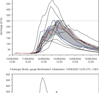
Sim-ulations for the Aue 1 gauge (left in Fig. 6) in the Western Ore Mountains show a “good” ensemble embracing the ob-served runoff, which was close to a 100 year recurrence level. The observed peak level is near the upper limit of the IQR confidence band and relatively close to the median of the en-semble members, but the spread is higher. For the Freiberger Mulde (Berthelsdorf gauge, right in Fig. 6) the flood event was underpredicted. Table 1 lists the probabilities of exceed-ing flood alert levels at the Berthelsdorf gauge. All COSMO-LEPS members have been equally weighted. The significant increase in probability of exceeding levels 3 and 4 between 09/08/ and 10/08/ is remarkable, as well as the decrease in 11/08/. Even though the forecasts underpredicted peak flow, a probability of 90% for significant inundation (alert level 3) and still 60% for severe damage and danger of life (alert level 4) would have shown a clear evidence of a large flood event two and a half days in advance.
S ch w a rzw a sse r, ga u ge A u e 1 , in itia liza tio n : 1 0 /0 8 /2 0 0 2 1 2 :0 0 U T C , + 1 3 2 h
0 5 0 1 0 0 1 5 0 2 0 0 2 5 0 3 0 0 3 5 0 4 0 0 4 5 0 5 0 0
1 0 /0 8 /2 0 0 2 1 2 :0 0
1 1 /0 8 /2 0 0 2 1 2 :0 0
1 2 /0 8 /2 0 0 2 1 2 :0 0
1 3 /0 8 /2 0 0 2 1 2 :0 0
1 4 /0 8 /2 0 0 2 1 2 :0 0
1 5 /0 8 /2 0 0 2 1 2 :0 0
di
s
c
har
g
e [
m
³/
s
]
F re ib e rge r M u ld e , ga u ge B e rth e lsd o rf, in itia liza tio n : 1 0 /0 8 /2 0 0 2 1 2 :0 0 U T C , +132 h
0 5 0 1 0 0 1 5 0 2 0 0 2 5 0 3 0 0 3 5 0 4 0 0 4 5 0 5 0 0
1 0 /0 8 /2 0 0 2 1 2 :0 0
1 1 /0 8 /2 0 0 2 1 2 :0 0
1 2 /0 8 /2 0 0 2 1 2 :0 0
1 3 /0 8 /2 0 0 2 1 2 :0 0
1 4 /0 8 /2 0 0 2 1 2 :0 0
1 5 /0 8 /2 0 0 2 1 2 :0 0
di
s
c
har
ge [
m
³/
s
]
Fig. 6.Discharge ensembles for different sub-catchments initialized from COSMO-LEPS hindcasts on 10/08/2002 12:00 UTC with two and a half days lead time to the peak discharge.
the beginning of the event to the initialization of the current forecast, the hydrograph is simulated using combined infor-mation from rain gauges and radar observations provided by Haberlandt (2007) for the 2002 case study. When a new fore-cast is available, the latest system state of the model (driven by observed rainfall) provides hydrological initial conditions for the forecast mode.
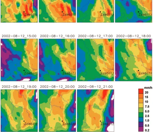
The hydrological simulations driven by COSMO-DE focasts underestimate discharge at the Z¨oblitz gauge with re-spect to the amplitude and the duration. In particular, the precipitation forecasts generate discharges of varying quality indicating that the latest COSMO-DE forecast not necessar-ily gives the best estimation of the observed discharge. This strengthens the need for a LAF approach as shown in Fig. 7. The COSMO-DE modelling chain predicts two major dis-charge events. The first peak is strongly underestimated by most runs, while for the second peak at least four runs in-dicate a strong increase of discharge. Figure 8 shows pre-cipitation patterns from two selected COSMO-DE runs
dis-120 140 160 180
m
³/s]
Schwarze Pockau, gauge Zöblitz, COSMO-DE forecasts 2002
observed discharge
simulated discharge driven by 3 hrly. COSMO-DE forecast runs (black/coloured lines) simulated discharge using observed rainfall
0 20 40 60 80 100
11/08/2002 00:00 11/08/2002 12:00 12/08/2002 00:00 12/08/2002 12:00 13/08/2002 00:00 13/08/2002 12:00 14/08/2002 00:00
discharge [
m HQ 100
Fig. 7. Simulated discharge for the Z¨oblitz gauge using observed rainfall and COSMO-DE predictions of precipitation (model time step 1 h).
Table 2. Exceedance of flood alert levels at Berthelsdorf as fore-casted by COSMO-DE. The head row shows the forecast hours from 11/08/2002 20:00. The other rows show the alert levels, which are exceeded by the forecasted discharge for each time step. The two bottom rows show the number of overlapping forecasts, which ex-ceed alert level 3 resp. 4. If the level has been exex-ceeded, the cells are marked as grey.
init. / forecast hr. 16 17 18 19 20 21 22 23 24 25 26 27 28 29 30 31 32 33 34 35 36 37 38 39 40 41 11/08/2002 18:00 0 0 1 1 1 0
11/08/2002 21:00 0 0 0 0 0 0 0 0 0 12/08/2002 00:00 0 0 0 0 0 0 0 0 1 1 1 2 12/08/2002 03:00 0 0 0 0 0 0 0 0 0 0 1 1 1 1 1 12/08/2002 06:00 0 0 0 0 0 0 0 1 1 1 1 1 2 2 2 2 3 3 12/08/2002 09:00 0 0 1 1 1 1 2 2 2 3 3 3 3 3 4 4 4 4 4 4 4
12/08/2002 12:00 1 2 2 2 3 3 3 3 3 3 3 3 3 3 3 3 4 4 4 4 4
12/08/2002 15:00 3 3 3 3 3 3 3 3 3 3 3 3 3 3 3 3 3 3 3 3
12/08/2002 18:00 4 4 4 4 4 4 4 4 4 4 4 4 4 4 4 4 3
12/08/2002 21:00 4 4 4 4 4 4 4 4 4 4 4 4 4 4
13/08/2002 00:00 4 4 4 4 4 4 4 4 4 4 4
13/08/2002 03:00 4 4 4 4 4 4 4 4
13/08/2002 06:00 4 4 4 4 4
13/08/2002 09:00 4 4
13/08/2002 12:00 13/08/2002 15:00 13/08/2002 18:00
exceed. of level 3 0 0 0 1 2 2 4 4 4 5 5 5 6 7 7 7 7 7 7 7 7 7 7
exceed. of level 4 0 0 0 0 0 0 1 1 1 2 2 3 4 4 4 5 6 6 6 6 6 6 5
Fig. 8.COSMO-DE forecasts for the Mulde catchment with forecast initialisations at 11/08/2007 18:00 UTC (first row, red forecast in Fig. 7) and 12/08/2007 00:00 UTC (second and third rows, green forecasts in Fig. 7) showing the first and second precipitation maximum in the Z¨oblitz catchment, respectively.
20 h of observed precipitation generating the highest ever recorded flood peak at the Z¨oblitz gauge.
Table 2 shows the persistence of threshold exceedances for flood alert levels at the Berthelsdorf gauge for the deter-ministic COSMO-DE forecasts. At 12/08/2002 06:00 UTC COSMO-DE gave the first evidence of a potential severe flood event exceeding alert level 3 19 h later (13/08/ 01:00). In the following initializations of the modelling chain the pre-dicted time of exceeding level 3 moved backwards to 12/08/ 15:00 (which is partly due to hydrologic uncertainty, see ris-ing limb of the calibrated hydrograph shown in Fig. 4). The model initializations from 12/08/ 18:00 on gave strong ev-idence of an extreme flood event. Nevertheless there was always at least one overlapping model run, which did not forecast the exceedance of level 4 (210 m2/s). The observed flood peak was 360 m2/s at 13/08/ 03:00.
Compared to the results of the forecasts driven by COSMO-LEPS, the performance of the COSMO-DE ini-tializations before 12/08/ 18:00 was surprisingly weak.
The very short-range forecasts did not provide more reliable exceedance probabilities than the medium-range forecasts did. However the very short-range forecasts per-formed better in estimating the peak discharge during the event (cf. results for the Z¨oblitz gauge shown above).
7 Conclusions
with an adaptive model control strategy. Compared with deterministic forecasts, probabilistic forecasts of discharge provide additional information to flood managers, who are addressed by the flood management strategy presented in Sect. 2 of this paper.
A part of the proposed flood management strategy has been successfully applied for the simulation of hindcasts for an extreme flood event. The LEPS and COSMO-DE hindcasts consistently underpredicted the rainfall rate of the 2002 extreme event. Nevertheless both systems evalu-ated within this case study produced evidences for a rainfall event which could cause a flood in the dimension of a 100 year recurrence period. If such a probabilistic forecast would already have been operationally available in August 2002, a reliable flood forecast would have been possible with a lead time of 2 to 3 days. Flood management would have been sig-nificantly improved compared to the deterministic forecast, which had been issued at that time. Both the COSMO-LEPS and COSMO-DE simulations did not always improve with more recent forecasts.
The derivation of decision rules, e.g. which exceedance probabilities should be used for issuing alerts or initiat-ing flood defence measures, is subject of ongoinitiat-ing research. Within the study area, ensemble hindcasts were only avail-able for one single extreme event. General conclusions about the skill of the models cannot be drawn from this case study. Currently the authors evaluate false alarms to extend their knowledge about the predictive skills of these models. In fu-ture work related to the forecast skill of the meteorological models, the study area will be extended in order to evaluate a larger number of extreme rainfall events. Further work of the authors is focused on the hydrological ensemble generation mechanisms. A detailed description and results from evalua-tion of this method will be published in a subsequent paper. The prototype of an operational system will be extended to the lower Mulde catchment including the adaptive control of flood routing and inundation models at vulnerable hot spots. The probabilistic approach will then enable an explicit con-sideration of risk and can thus further improve the basis for decision making in operational flood management.
The presented ensemble based flood forecast strategy does not directly address long-term strategic flood management. Nevertheless it is aimed to be an integral part of a sustain-able flood management policy. The longer forecasting hori-zon, the possible reduction of the number of false alerts and a detailed prediction of expected flood damage can improve the preparedness of affected people and thus reduce potential damage.
Acknowledgements. The research reported in this paper was carried out with support from the German Ministry for Education and Research (BMBF) under the initiative “Risk Management of Extreme Flood Events (RIMAX)”. The authors thankfully
acknowledge funding. B. Pf¨utzner (B¨uro f¨ur Angewandte
Hydrologie BAH Berlin) provided source code and support
of the ArcEGMO model. Data and practical experience have
been contributed by the State Flood Center of Saxony (Dres-den), the Saxonian Reservoir authority (Pirna), the Saxonian land survey authority and the National German Weather Service (DWD).
Edited by: S. Vannitsem
Reviewed by: J. Cullmann and another anonymous referee
References
Ajami, N. K., Duan, Q., and Sorooshian, S.: An integrated hy-drologic Bayesian multimodel combination framework: Con-fronting input, parameter, and model structural uncertainty in hydrologic prediction, Water Resour. Res., 43, W01403, doi:10.1029/2005WR004745, 2007.
Ajami, N. K., Gupta, H., Wagener, T., and Sorooshian, S.: Cal-ibration of a semi-distributed hydrologic model for streamflow estimation along a river system, J. Hydrol., 298, 1–4, 112–135, 2004.
Anderson, J. L.: A method for producing and evaluating proba-bilistic forecasts from ensemble model integrations, J. Clim., 9, 1518–1530, 1996.
Apel, H., Thieken, A. H., Merz, B., and Bl¨oschl, G.: Flood risk assessment and associated uncertainty, Nat. Hazards Earth Syst. Sci., 4, 295–308, 2004,
http://www.nat-hazards-earth-syst-sci.net/4/295/2004/.
Bartels, H., Dietzer, B., Malitz, G., Albrecht, F. M., and Gutten-berger, J.: Starkniederschlagsh¨ohen f¨ur Deutschland, KOSTRA-DWD-2000. Fortschreibungsbericht, Deutscher Wetterdienst – Hydrometeorologie, Offenbach, 2005.
Becker, A. and Gr¨unewald, U.: Disaster management: flood risk in Central Europe, Science, 300, 5622, 1099, 2003.
Becker, A., Kl¨ocking, B., Lahmer, W., and Pf¨utzner, B.: The hydro-logical modelling system ARC/EGMO, in: Mathematical models of large watershed hydrology, edited by: Singh, V. P. and Fre-vert, D. K., Water Resources Publications, Littleton/Colorado, 914 pp., 2002.
Beven, K. J., and Binley, A.: The future of distributed models: model calibration and uncertainty prediction, Hydrol. Process., 6, 279–298, 1992.
Buizza, R., Houtekamer, P. L., Toth, Z., Pellerin, G., Wei, M., and Zhu, Y.: A comparison of the ECMWF, MSC, and NCEP Global Ensemble Prediction Systems, Mon. Weather Rev., 133, 1076– 1097, 2005.
B¨uttner, U., F¨ugner, D., and Winkler, U.: Das Hochwasser am 5./6. Juli 1999 im Raum Marienberg im Erzgebirge, Hydrologie und Wasserbewirtschaftung, 45, 3, 102–111, 2001 (The flood on 5 and 6 July 1999 in the region of Marienberg in the Ore Moun-tains, Saxonia, in German with English abstract and captions). Carpenter, T. M. and Georgakakos, K. P.: Intercomparison of
De Roo, A., Gouweleeuw, B., Thielen, J., et al.: Development of a European Flood Forecasting System, I. R. B. M., 1, 1, 49–59, 2003.
Denhard, M. and Trepte, S.: Calibration of the
Euro-pean multi-model ensemble SRNWP-PEPS, Second THOR-PEX international science symposium, WMO/TD No. 1355, WWRP/THORPEX No. 7, 2006.
Doms, G. and F¨orstner, J.: Development of a kilometre-scale NWP-system: LMK, Doms, G., Sch¨attler, U., and Montani, A. (edi-tors), COSMO Newsletter No. 4, 168–176, 2004.
Evensen, G.: Sequential data assimilation with a nonlinear quasi-geostrophic model using Monte Carlo methods to forecast error statistics, J. Geophys. Res., 99, 10 143–10 162, 1994.
Georgakakos, K. P., Seo, D.-J., Gupta, H., Schaake, J., and Butts, M. B.: Towards the characterization of streamflow simulation uncertainty through multimodel ensembles, J. Hydrol., 298 (1– 4), 222–241, 2004.
Gouweleeuw, B., Thielen, J., Franchello, G., De Roo, A., and Buizza, R.: Flood forecasting using medium-range probabilistic weather prediction, Hydrol. Earth Syst. Sci., 9, 365–380, 2005, http://www.hydrol-earth-syst-sci.net/9/365/2005/.
Haberlandt, U.: Geostatistical interpolation of hourly precipitation from rain gauges and radar for a large-scale extreme rainfall event, J. Hydrol., 332, 144–157, 2007.
Hoeting, J. A., Madigan, D., Raftery, A. E., and Volinsky, C. T.: Bayesian model averaging: A tutorial with discussion. Statisti-cal Science, 14, 382–417, 1999, Printing errors corrected in ver-sion available at http://www.stat.washington.edu/www/research/ online/hoeting1999.pdf.
Hoffman, R. N. and Kalnay, E.: Lagged average forecasting, an alternative to Monte Carlo forecasting, Tellus, 35A, 100–118, 1983.
Holtan, H. N.: A concept for infiltration estimates in watershed en-gineering, Agr. Res. Service Pub., U.S. Dept. Agr., 41–51, 1961. Kalnay, E.: Atmospheric modelling, data assimilation and
pre-dictability, Cambridge University Press, 512 pp., 2002. Klink, S. and Stephan, K.: Latent heat nudging and prognostic
pre-cipitation, COSMO Newsletter, 5, 124–131, 2005.
Krzysztofowicz, R.: Bayesian system for probabilistic river stage forecasting, J. Hydrol., 268, 16–40, 2002.
Lorenz, E. N.: Deterministic Nonperiodic Flow, J. Atmos. Sci, 20, 130–141, 1963.
Marsigli, C., Boccanera, F., Montani, A., and Paccagnella, T.: The COSMO-LEPS mesoscale ensemble system: validation of the methodology and verification, Nonlin. Processes Geophys., 12, 527–536, 2005,
http://www.nonlin-processes-geophys.net/12/527/2005/. Molteni, F., Buizza, R., Marsigli, C., Montani, A., Nerozzi, F., and
Paccagnella, T.: A strategy for high-resolution ensemble pre-diction, part I: definition of representative members and global model experiments, Q. J. Roy. Meteor. Soc., 127, 2069–2094, 2001.
Montani, A., Marsigli, C., Nerozzi, F., Paccagnella, T., Tibaldi, S., and Buizza, R.: The Soverato flood in Southern Italy: per-formance of global and limited-area ensemble forecasts, Nonlin. Processes Geophys., 10, 261–274, 2003,
http://www.nonlin-processes-geophys.net/10/261/2003/.
Mullusky, M., Demargne, J., Welles, E., Wu, L., and Schaake, J.: Hydrologic applications of short and medium range ensemble forecasts in the NWS, Advanced Hydrologic Prediction Services (AHPS), Extended Abstract, 84, AMS Meeting, Seattle, WA. Jan. 10.–16., 2004.
Pappenberger, F., Beven, K. J., Hunter, N. M., Bates, P. D., Gouweleeuw, B. T., Thielen, J., and de Roo, A. P. J.: Cas-cading model uncertainty from medium range weather forecasts (10 days) through a rainfall-runoff model to flood inundation pre-dictions within the European Flood Forecasting System (EFFS), Hydrol. Earth Syst. Sci., 9, 381–393, 2005,
http://www.hydrol-earth-syst-sci.net/9/381/2005/.
Raftery, A. E., Gneiting, T., Balabdaoui, F., and Polakowski, M.: Using Bayesian Model Averaging to calibrate forecast ensem-bles, Mon. Weather Rev., 133, 1155–1174, 2005.
Reed, S., Schaake, J., and Zhang, Z.: A distributed hydrologic model and threshold frequency-besed method for flash flood forecasting at ungauged locations, J. Hydrology, 337, 402–420, 2007.
Schaake, J. C., Hamill, T. M., Buizza, R., and Clark, M.: HEPEX: The Hydrological Ensemble Prediction Experiment, Bull. Amer. Meteor. Soc., 88, 10, 1541–1547, 2007.
Sloughter, J. M., Raftery, A. E., and Gneiting, T.: Probabilistic quantitative precipitation forecasting using Bayesian Model Av-eraging, Tech. report 496, Department of Statistics, University of Washington, USA, 2006.
Smith, M. B., Seo, D.-J., Koren, V. I., Reed, S. M., Zhang, Z., Duan, Q., Moreda, F., and Cong, S.: The distributed model inter-comparison project (DMIP): motivation and experiment design, J. Hydrol., 298 (1–4), 4–26, 2004.
Steppeler, J., Doms, G., Sch¨attler, U., Bitzer, H. W., Gassmann, A., Damrath, U., and Gregoric, G.: Meso-gamma scale forecasts using the nonhydrostatic model LM, Meteorol. Atmos. Phys., 82, 75–96, 2003.
Thielen, J., Bartholmes, J., Ramos, M.-H., and de Roo, A.: The Eu-ropean Flood Alert System – Part 1: Concept and development, Hydrol. Earth Syst. Sci. Discuss., 5, 257–287, 2008,
http://www.hydrol-earth-syst-sci-discuss.net/5/257/2008/. Toth, Z., Talagrand, O., Candille, G., and Zhu, Y.: Probability and
ensemble forecasts, in: Joliffe, I. T. and Stephenson, D. B. (eds.): Forecast verification: a practitioner’s guide in atmospheric sci-ence, John Wiley & Sons, 2003.
Trepte, S., Denhard, M., G¨ober, M., and Anger, B.: SRNWP-PEPS: some results of verification, Second THORPEX international sci-ence symposium, WMO/TD No. 1355, WWRP/THORPEX No. 7, 2006.
Verbunt, M., Zappa, M., Gurtz, J., and Kaufmann, P.: Verification of a coupled hydrometeorological modelling approach for alpine tributaries in the Rhine basin, J. Hydrol., 324, 224–238, 2006. Wang, Y., Dietrich, J., Voss, F., and Pahlow, M.: Identifying and
reducing model structure uncertainty based on analysis of pa-rameter interaction, Adv. Geosci., 11, 117–122, 2007,