DOI: 10.1590/2175-3369.009.SUPL1.AO05
ISSN 2175-3369
Licenciado sob uma Licença Creative Commons
Mafalda Batista Pacheco[a], Itziar Navarro-Amezketa[b], Teresa Heitor[c]
Mapping the urban form of coastal fishing towns in Algarve:
Olhão and Vila Real de Santo António
Mapeamento da forma urbana de cidades piscatórias no
Algarve: Olhão e Vila Real de Santo António
[a] CERIS, Instituto Superior Técnico, Universidade de Lisboa, Lisboa, Portugal
[b] Escuela Tecnica Superior de Arquitectura, Univeridad Politécnica de Madrid, Madrid, [c] CERIS, Instituto Superior Técnico, Universidade de Lisboa, Lisboa, Portugal
Abstract
The paper examines the urban growth patterns of two coastal fishing towns in southern Portugal: Olhão and Vila Real de Santo António. The goal is to investigate the relationship between the configurational and network properties of the urban forms in order to identify generative or emergent patterns, understanding their particular urban morphology. The Space Syntax Theory, applied to the syntactical modelling of these towns, is used to understand the urban processes. Topological variables, such as connectivity, integration and intelligibility, are calculated by DepthMap Software and the Theory of the “Deformed Wheel” is used to represent the evolutionary trends and to identify generic rules. The study is developed by comparing the two urban networks in two moments of their evolution, first in the mid-20th century, which corresponds to the historic core, and second corresponding to the present day. The main results demonstrate a contrast be -tween the segregated network of Olhão's irregular historic centre and the integrated network of Vila Real de Santo António's regular historic centre, revealed by the value of integration variable. The urban expansion of these towns during the last decades decreased the value of integration and aggravated the intelligibility of the urban fabric. The application of syntactic approaches, with quantitative analysis, aims to complement the traditional procedures of the History of Urbanism, developing an operational method adaptable to the study of urban morphology.
Keywords: Urban morphology. Space syntax theory. Deformed wheel model. Coastal fishing towns. Algarve.
MBP is Architect, Master in Architecture, Universidade de Lisboa, e-mail: [email protected] INA is Architect, Master in Architecture, e-mail: [email protected]
Resumo
O artigo analisa os padrões de crescimento urbano de duas cidades piscatórias do sul de Portugal: Olhão e
Vila Real de Santo António. O objectivo é investigar a relação entre as propriedades configuracionais e a orga
-nização espacial e formal dos núcleos urbanos, de forma a identificar os modelos emergentes ou geradores, e
compreender a sua morfologia urbana particular. A modelação sintática destas cidades, por meio da aplicação da Teoria da Sintaxe Espacial, é utilizada na compreensão dos processos de crescimento urbano. As variáveis topológicas, como a conectividade, a integração e a inteligibilidade, são calculadas pelo Software DepthMap e
é usada a Teoria da “Roda Deformada” para representar as tendências evolutivas e identificar regras genéri -cas. O estudo realiza-se através da comparação das duas redes urbanas em dois momentos da sua evolução, o primeiro em meados do século XX que corresponde ao núcleo histórico, e o segundo que corresponde aos dias de hoje. Os principais resultados demonstram um contraste entre a rede segregada do centro histórico irregular de Olhão e a rede integrada do centro histórico regular de Vila Real de Santo António, revelado pelo valor da variável integração. No entanto, a expansão urbana dessas cidades, durante as últimas décadas, fez diminuir o valor da integração e agravou a legibilidade da rede urbana. A aplicação de abordagens sintáticas, mais quantitativas, têm como objectivo complementar os procedimentos tradicionais de análise da história urbana, desenvolvendo um método operacional aplicável ao estudo da morfologia urbana.
Palavras-chave: Morfologia urbana. Teoria da sintaxe espacial. Modelo da roda deformada. Cidades
piscató-rias. Algarve.
Introduction
The coastal fishing towns in Algarve, in the
south of Portugal, have suffered an intense urban
evolution during the last four decades. One of the
reasons has been a growing demand for leisure and tourist areas, evolving the economic changes
from an economy based on fishery to tourism,
resulting in a disruption of the traditional urban
fabric’s continuity: from the historic urban cores
emerged axes where settle new urban areas, iso -lated neighborhoods and residential condominiu -ms. Although some research has been carried out
in the field of the urban morphology of Algarve’s towns, following qualitative (Ribeiro, 2015) or
quantitative methodologies (Navarroet al., 2015;
Pacheco & Heitor, 2012; Pacheco et al., 2015; Silva et al., 2015, 2016), the implications of these urban
interventions and their features for the global ur -ban system, have not been studied yet.
This research examines the urban evolution of
two fishing towns on the coast of Algarve, Olhão
and Vila Real de Santo António. These towns were chosen for their different morphologies, in order to identify the spatial typologies that characteri
-ze their urban fabric in two different periods of its evolution. By analyzing the configuration and
urban shape according to the city’s model of the
“Deformed Wheel”, defined by the Space Syntax Theory (Hillier, 2005, 2009), this research enables
the morphological characteristics of the historic
fishing towns to be understood. This real
diagno-sis of the evolution of urban towns links quanti -tative approaches to the traditional urban history analysis and develops a functional urban morpho -logy method to use in future urban interventions.
Olhão is a fisherman's town built between the
18th and the beginning of the 20th century, althou
-gh the first settlements go back to 16th century. Its
historical centre presents a homogeneous urban
fabric characterized by a primitive neighborhood
with irregular tissue of narrow streets, along the shoreline, contrasting with the more regular fur
-ther urbanization of the rural areas (Figure 1a, 1c). The first map of Olhão was published in 1961,
in the chapter Zone 6, corresponding to Algarve’s region of the book Arquitectura Popular em Portugal (Popular Architecture in Portugal), as a
resulted of the surveys on Portuguese regional ar -chitecture, carried out by the National Architects
Syndicate during the 1950’s (Martins et al., 2004,
p. 269). In 2008, Olhão’s urban evolution was
stu-died in a historical and morphological perspec
Mapping the urban form of coastal fi shing towns in Algarve
315
were selected because of their geographic
proxi-mity, similar parameters of population number
and settlement area dimension, but different ur-ban form configuration.
a)
b)
c) neighborhoods and the urbanization expansion to
rural areas (Romba, 2015, p. 129-130).
Vila Real de Santo António is the southern
Portuguese town, settled 50km east of Olhão cha-racterized by a regular urban fabric, a grid planned
and built in the last quarter of the 18th century,
ac-cording to the Enlightenment period ideals, after
the earthquake of 1755 destroyed mainly Lisbon and the Algarve’s coast (Figure 1b, 1d). Vila Real de Santo António was built between 1774 and 1776 and settled in front of the Spanish town of Ayamonte, with the strategic purpose to con-trol the fishery industry in the southern Algarve (Correia, 1997, 2010, p. 10).
This research aims at validating two hypotheses: 1) the configuration of the coast fishing towns in
Algarve can be studied by applying the “Deformed
Wheel” model, defined in the Space Syntax Theory (Hillier, 2005) the urban evolution of the towns may be related to the syntactic values of
connec-tivity, integration and intelligibility, featuring the quality and perception of the urban space.
The present study has the following specific aims: i) the calculation of the variables of the con-figuration of two towns: the qualitative variables
of the irregular and regular urban structure, and quantitative variables connectivity, integration
and intelligibility, defined by the Space Syntax Theory (Hillier, 2005); ii) the analysis of the re-sults of the two towns’ configuration and to
iden-tify the sectors of the “Deformed Wheel Model”
(Hillier, 2005, 2009); iii) the comparison of the ur-ban configuration of the towns according to their
actual urban extension and their historic centre,
implying the analysis of four urban models; iv) the interpretation of these four urban models
accor-ding to the intelligibility of the network and the quality of the urban space.
Materials and methods
The investigation follows a comparative me-thod for the study of four models of urban settle-ments of two towns, Olhão and Vila Real de Santo António, in two different periods: one on the
be-ginning of the 20th century, corresponding to the
historic centre, and the other on the end of 2015,
configurational spatial structure of the system (Hillier & Hanson, 1984).
This methodology establishes procedures and
tools to research the city configuration, based on a
topological analysis that considers the spatial re -lation, not depending of parameter like form and
size, but functions and hierarchies. It is a tool that
potentiates the improvement of the space quali
-ty of the cities based on the configurational
va-riables of the urban plan. The urban articulation between hierarchies and permeability, connected
with form-space, clarifies about the actual stage
of the urban quality, contributing to interpret and
to act on the cities’ network (Medeiros, 2006).
The Space Syntax Theory contemplates tech -niques of perception and representation of space, creating values, proposing a relationship betwe
-en configurations of space in the city and the way
it works. It has three different ways to represent
the configurational studies: convex spaces,
vi-sual camps and axial lines. As the cognitive re -presentation of complex spaces is geometrically discontinuous, and understands the urban spa -ce as assemblies of geometric elements inter — connected (and not as a complex patterns of
metric distances), the representation with axial
lines is appropriate to study great structures’ movements, such as cities and its urban features
(Hillier & Hanson, 1984; Hillier, 1996, 2005;
Al-Sayed et al., 2014).
Syntactic variables such as segment number, connectivity, global integration and intelligibility
seeks to formulate mathematically the
configu-rational properties of space. Segment’s number variable illustrates the urban plan correspondent axes. Connectivity shows the number of lines that each axe intersects with. Global integration refers to the potential of topological accessibility, calcu -lated for the entire system and considering the global properties “Rn” (where “R” corresponds to the radius and “n” to the unlimited number of possible connections from any place of the sys
-tem), and it is represented by global colored up
from red to blue, forming a pattern like a “defor
-med wheel” (Hillier, 2005, 2009). Intelligibility
concept applied to space analysis corresponds to the correlation between connectivity and glo -bal integration’s values of the system axes, re
-sulting in the coefficient of determination, which d)
Figure 1 - Hydrographical plans of the ports of Olhão (a) and Vila Real de Santo António (b); and aerial views of Olhão (c) and Vila Real de Santo António (d).
Sources: Folque, 1885 (1a), Folque, 1881 (1b), Google maps, 2015a (1c), Google maps, 2015b (1d).
The chosen method for this analysis is based
on the Space Syntax Theory (Hillier, 2005). The
procedure of the syntactical modeling analysis, including topological variables like segment num -bers, connectivity, integration and intelligibility, is used for modeling the evolutionary trends and to identify generic “rules” of an urban growth. The Theory of Space Syntax is applied using the DepthMap’s Software, generating a group of digi
-tal data (Turner, 2004) and allowing the
compari-son between past and present urban network of towns (Navarro et al., 2015).
The Space Syntax integrates a set of theoreti -cal and methodologi-cal procedures for the analy
-sis of spatial configurations and was developed in the 1970’s at the Bartlett School, University
College London, by a team led by Bill Hillier and Julienne Hanson. The syntactic model is built as a descriptive model for the study of “urban and architectural form”. Its main intention is expla
-natory, seeking to characterize and to interpret
Mapping the urban form of coastal fishing towns in Algarve
317
indicates the degree of dependence of one varia
-ble to another. This coefficient is closely related
to the existence of long axes that cross the whole system. If the system has just a few global axes, there is less changes to be intelligible, and the global — local relationship is compromised be
-cause of the difficulty to realize the entire system (Medeiros, 2006).
The perception is made by parts and conse -quently restricted to certain areas of space. This principle is associated with the notions of topolo
-gical perception (Kohlsdorf, 1996) concerning to the difficulties or facilities in the orientation and
location of the people passing through urban spa -ce. So, the addition of new segments or changes in the geometry of the city tends to cause fragmen
-tation in the configuration, by breaking the conti-nuity of space (Medeiros, 2006).
The theory of the “Deformed Wheel Model” as
-sumes that the urbanism's evolution of the city is
similar to the structure of a wheel. According to
Hillier:
we find generic spatial patterns. The most com-mon follows a simple principle: that the rela-tions to ambient centres around the area form a dominant multidirectional structure within the area, often approximating something like the familiar ‘deformed wheel’ pattern, reflected in syntactic values, and sometimes generating an even smaller scale centre within the area (Hillier, 2009, p. 8).
The wheel forms the dominant pattern of pu -blic space, where is the commercial area, while
the interstices' areas are more residential, with
gradations between the two, which relates the urban form with the social and economical life of the town. The model represents the overcoming of the natural tendency for centres to become se -gregated as the city grows around them by linking
centres to the edges (Hillier, 2005, 2009). By re-presenting the integration's variable values, from red to blue, it is find the main integrators lines (red, orange and yellow) with a “hub”, or, at least,
an intersection of integrated lines at the centre or near it, integrated “spokes”, which link the centre to the “edge” and an integrated “rim” of edge lines.
The Space Syntax's variables involved in this study are separated in three groups:
1) “Urban form and distribution” analysis: - Urban form as a qualitative nomi
-nal attributes, that can be continuous or discontinuous, measured in each
neighborhood type, and defined by DepthMap reference number attribute; - Morphology of axial map as a qualita -tive nominal attributes, that can be reg -ular or irreg-ular network, measured in
each neighborhood type, defined by DepthMap reference number attribute; - Intersection type as a qualitative nomi -nal attributes that can be with perpen
-dicular (T) or oblique angles (X) of the
crossroads.
-2) “Topological” analysis:
- Connectivity as a quantitative discrete attribute with average, minimum and maximum values, measured in the ur
-ban models;
- Integration as a quantitative continue attribute with average, minimum and maximum values, measured in the ur
-ban models;
- Intelligibility, in function of connectiv -ity and integration correlation, mea -sured by the quantitative continues
coefficient of determination (R2),
vary-ing between 0 and 1.
-3) “Deformed Wheel Model” (DWM) analysis: - Axes count as a quantitative discrete
value, measured in each sector of the
“Deformed Wheel Model”: “1” for the most integrated axe, “2” for the inte-gration core, “3” for radius on centre, “4” for radius on periphery, “5” for arch axes, “6” for integrated residen-tial inside the core, “7” for segregated residential inside the core, “8” for
in-tegrated residential on periphery arch
- Percentage of axes as quantitative con -tinuous, measured in each sectors of
DWM;
- Mean Integration as quantitative con -tinuous, measured in each sectors of
the DWM;
- Mean Connectivity as quantitative continuous, measured in each sectors
of the DWM;
- Intelligibility, in function of connectiv -ity and integration correlation, as a
quantitative continuous coefficient of
determination (R2), which varies
be-tween 0 and 1, measured in each
sec-tors of the DWM.
Using digital cartography of the towns, it was drawn the correspondent lines of the urban struc -ture and imported to the DepthMap Software, transforming lines into the Axial Map. The “graph analysis” was run and the descriptive statistics of each topological variable were calculated, such as mean, maximum, minimum, standard deviation, and sectors diagrams. For the correlation between two quantitative variables, such as intelligibility
(integration/connectivity), it was used the gra-phics “regression plot” and “coefficient of
deter-mination” (R2).
Main findings and results
“Urban form and distribution” analysis of Olhão and Vila Real de Santo António
The town of Olhão has continuous urban shape with an irregular morphology and oblique's inter-sections (Table 1), while the urban core has a con-tinuous urban shape with two kinds of network:
regular network with perpendicular intersections and irregular network with oblique intersections, where public space is a result of the dwellings
constructions. The beginning of Olhão was a
settle-ment next to the shoreline and the port, where the
fishery activity happens. The shoreline
determi-nates the development of the town to north, a ru -ral area, where the reticule layout of the farmland
areas originates a semi-regular network (Romba, 2015, p. 83-84). The development of the urban
network occurred from the shoreline to north, cha
-racterized by discontinuous occupations with
irregu-lar network and oblique and orthogonal intersections. It is an area of low density of axes per m². However, next to the shoreline, the urban core maintains the continuous shape, with regular and irregular sectors and higher density.
The Vila Real de Santo António's core was built
following a detailed urban plan, based on an ortho -gonal reticule with the riverfront as the main axis, composed by perpendicular streets, rectangular and quadrangle quarters and squares, standard buildin -gs façades, and a hierarchic distribution of building uses and streets circulation, resulting a “balanced”
drawing plan (Correia, 2010, p. 11-13). The
regu-lar network contemplates some discontinuities in its core, due to the placement of squares instead of quarters, according with the original urban plan.
The urban development of the town during the 20th
century followed an axis from the shoreline to the western interior areas, in a discontinuous form and
creating two kinds of network: the regular ones,
next to the shoreline and perpendicular intersec -tions of the streets, and the irregular network in
interior areas with oblique intersections (Table 1).
“Topological” analysis of Olhão and Vila Real de Santo António
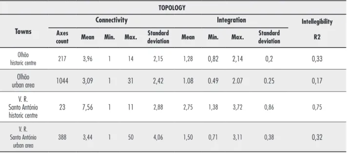
Although the settlement areas of Olhão and
Vila Real de Santo António are similar, their “axes count” values differ according their urban fea
-tures: Olhão counts on 217 elements while Vila Real de Santo António counts on 23 elements.
The irregular urban structure of Olhão, cha-racterized by short streets and fragmented
seg-ments, raises the number of axes of the system, contrary to the orthogonal structure of Vila Real de Santo António with defined axes and long streets, reducing the number of lines of the sys -tem. The urban growth of both towns increased
the “axes count” values. In Olhão, where the
ur-ban fabric maintained the same logical structure,
the factor of increasing is 4,8, an expected value.
However, Vila Real de Santo António has an unex
-pected factor of increasing of 16,9 due to change
of type of urbanism, from the regular to the irre
Mapping the urban form of coastal fishing towns in Algarve
319
Table 1- Values of “urban form and distribution” variables. URBAN FORM AND DISTRIBUITION
Sectors of the urban morphology
Shape of urban fabric Axial map
morphology Intersection type Axial map with sectors of the urban morphology (continuous or
discontinuous)
(regular or
irregular network) (T or X)
Olhão
urban area
1 red Cont. Irreg. X
2 orange Cont. Irreg. X
3 yellow Cont. Irreg. X
4 light green Cont. Irreg. X
5 green Cont. Irreg. T
6 dark green Cont. Irreg. T
7 light blue Cont. Reg. T
8 blue Cont. Reg. T
9 dark blue Cont. Reg. T
Summary: Continuous Irregular/
Regular XT
Olhão
urban area
1 red Cont. Irreg. X
2 orange Cont. Irreg. X
3 yellow Discount. Irreg. X
4 light green Discount. Irreg. X
5 green Discount. Irreg. T
6 dark green Cont. Irreg. T
7 light blue Cont. Reg. T
8 blue Cont. Reg. T
9 dark blue Cont. Reg. T
Summary: Discontinuos/ Continuous
Irregular/
Regular XT
V. R. Santo António historic centre
1 red Discount. Reg. T
Summary: Discontinuous Regular T
V. R. Santo António
urban area
red Discount. Reg. X
yellow Discount. Irreg. X
light green Discount. Irreg. X
green Discount. Irreg. X
blue Discount. Reg. T
dark blue Discount. Reg. T
Summary: Discontinuous Irregular/
Regular XT
The historic centre of Vila Real de Santo António
presents the highest mean connectivity value (7,56),
but concerning to the actual town, the value lower to
half (3,44). The regular plan (perpendicular system with long axes) allows more connections between the streets. Olhão, with an irregular urbanism in both
stages of the evolution, maintain the mean connecti
-vity value (around 3) (Table 2).
The actual town of Vila Real de Santo António pre
-sents the “maximum connectivity” value (50),
conse-quence of the urban development around a princi -pal axis (composed by three streets, called Estrada Nacional 125, Avenida dos Bombeiros and Rua Dr. Teófilo Braga) that crosses entire town. The mean connectivity value concerning to Olhão and Vila Real de Santo António today's urban form decreased due
to the urban development based on the tourism sce -nario (i.e. “sun and beach” tourism requirements and
“second residency” tendency) (Table 2).
Vila Real de Santo António historic centre has the
highest value of mean integration (2,75). Its
ortho-gonal network explains the high integration of a big number of streets into the system. Both actual towns decreases the mean integration value, specially Vila
Real de Santo António (1,50), due to the urban
deve-lopment based on the tourism economy. Concerning to the intelligibility variable (R2), Vila Real de Santo
António historic centre intelligibility is almost the
maximum (0,75 of 1), although the actual Olhão has the lowest intelligibility value (0,17) indeed, like
ac-tual Vila Real de Santo António. The variables inte -gration and connection are directly related with in -telligibility value of R2, soboth towns decreased the intelligibility variable (R2) almost half of the value.
The highest values (near 1) means that the town is
highly perceived and the orthogonal network contri -butes to understand the town easily. The new urban network, result of the touristic needs, worsened the
intelligibility of the towns (Table 2).
Table 2 - Values of “topological” variables.
TOPOLOGY
Towns
Connectivity Integration Intellegibility
Axes
count Mean Min. Max.
Standard
deviation Mean Min. Max.
Standard
deviation R2
Olhão
historic centre 217 3,96 1 14 2,15 1,28 0,82 2,14 0,2 0,33
Olhão
urban area 1044 3,09 1 31 2,42 1.08 0.49 2.07 0.25 0,17
V. R. Santo António historic centre
23 7,56 1 11 2,88 2,75 1,38 3,72 0,86 0,75
V. R. Santo António
urban area
388 3,44 1 50 4,06 1,50 0,71 3,11 0,38 0,32
Source: authors.
“Deformed Wheel Model” sectors’ analysis
A reading of the topological variables of Olhão
and Vila Real de Santo António’s urban structures
are presented in the Tables 3 to 6. It is aimed to do
a comparative analysis, to identify the similar and different patterns between the two periods of evo
-lution and the two towns. The first comparison,
between the two periods of evolution — beginning
of the 20th century and in 2015 — for each town,
allows the identification and quantification of the urban axes' position inside the syntactic modeling
Mapping the urban form of coastal fi shing towns in Algarve
321
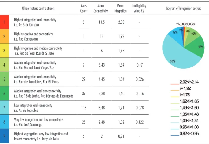
The historic centre of Olhão presents a main concentration of axes (53%) in the category of
“low integration and connectivity”, meaning a low
intelligibility of the nucleus. Actually, the main con-centration of axes (33%) occurs in the category of
“median integration and low connectivity” and also
decreasing for the same period the axes of “low in-tegration and connectivity” (17%). It is supposed
that the urban expansion happened in this period
was done following long axis and a regular allot-ment (Tables 3 and 4).
The historic centre of Vila Real de Santo António presents the mainly concentration of axes in two
opposite categories: the “highest integration and connectivity” (31%) and in the opposite extreme
“low integration and lowest connectivity”, which
means the highest segregation (22%) (Table 5).
For the actual urban area of Vila Real de Santo
António the concentration of axes prevails in the ca-tegory of “low integration and connectivity” (26%)
and “median integration and low connectivity”
(23%), also occurring a decrease of both predomi-nant categories in the urban centre, analyzed befo-re, “highest integration and connectivity” (0,5%) and “low integration and lowest connectivity” (6%).
The potential of integration for the historic centre
is due to the configuration of the regular urban
ne-twork, and the changes of the urban characteristics for a predominant structure with lower integration and connectivity, is a result of the urban expansion
around just one axis (composed by three streets,
cal-led Estrada Nacional 125, Avenida dos Bombeiros and Rua Dr. Teófilo Braga), as well as the new allotments following an alike regular geometry (Table 6).
Comparing the global integration values for the two historic centres and for actual urban areas, it is perceptible a similarity between the concentration of main axis in the categories of “low integration and connectivity” and “median integration and low
connectivity”. The count of these categories, Olhão and Vila Real de Santo António presents 50% and 49%, respectively, showing uniformities.
Table 3 - Sectors of “Deformed Wheel Model” in Olhão historic centre.
Olhão historic centre streets Axes Count
Mean Connectivity
Mean Integration
Intelligibility
value R2 Diagram of Integration sectors
1 Highest integration and connectivity
i.e. Av. 5 de Outubro 2 11,5 2,08
-2 High integration and connectivity
i.e. Rua Conserveira 1 13 1,92
-3 High integration and median connectivity
i.e. Rua da Feira, Rua de S. José 1 6 1,75
-4 Median integration and connectivity
i.e. Rua Manuel Tomé Viegas Vaz 7 5,43 1,64 0,17
5 Median integration and connectivity
i.e. Rua das Lavadeiras, Rua Gil Eanes 22 4,45 1,54 0,026
6 Median integration and low connectivity
i.e. Rua 18 de Junho, Rua Dâmaso da Encarnação 39 5,38 1,40 0,016
7 Low integration and connectivity
i.e. Av. da Républica 115 3,48 1,21 0,078
8 Very low integration and low connectivity
i.e. Rua José Saramago 25 2,48 1,02 0,122
9 Highest segregation: very low integration and
-Scatter Plot of Intelligibility Axial Map of Global Integration
Source: authors.
Table 4 - Sectors of “Deformed Wheel Model” in Olhão urban area.
Olhão historic centre streets Axes Count
Mean
Connectivity Mean Integration
Intelligibility
value R2 Diagram of Integration sectors
1 Highest integration and connectivity
i.e. Estrada Nacional 125 1 31 2,07
-2
High integration and connectivity
i.e. Rua Almirante Reis, Rua Dâmaso da Encarna-ção, Rua 18 de Junho, Av. da República
5 18 1,80 0,017
3
High integration and median connectivity i.e. Av. 5 de Outubro, Rua do Serrinho, Rua Calouste Gulbenkian
31 5,16 1,64 0,287
4
Median integration and connectivity i.e. Rua Caminho de Ferro, Av. dos Operários Conserveiros, Av. 16 de Junho
56 4,21 1,50 0,003
5 Median integration and connectivity
i.e Rua da Feira, Estrada de Quelfes 344 3,39 1,26 0,027
6
Median integration and low connectivity i.e. Bairro dos Pescadores, Rua Cerca do Júdice, José Saramago, Azinhaga da Patinha
286 2,81 1,03
0,030
7
Low integration and connectivity
i.e. Urbanização do Turolhão, Bairro do Neves, Bairro 28 de Setembro
182 2,45 0,88 0,015
8
Very low integration and low connectivity i.e. Bairro Novo, Bairro do Barreta, Bairro dos Sete Cotovelos.
110 2,14 0,74 0,007
9
Highest segregation: very low integration and lowest connectivity
i.e. Urbanização Zona Alta
-Mapping the urban form of coastal fi shing towns in Algarve
323
Scatter Plot of Intelligibility Axial Map of Global Integration
Source: authors.
Vila Real de Santo António historic centre streets
Axes Count
Mean Connecti-vity
Mean Integra-tion
Intelligi-bility
value R2 Diagram of Integration sectors
1
Highest integration and connectivity i.e. Av. da República, Rua da Princesa Rua José Barão, Rua Jornal do Algarve Rua Benemérito, Rua Dr. Sousa Martins, Rua Almirante Cândido dos Reis, Rua Dr. Oliveira Martins,
Rua Jacinto José de Andrade
7 9 3,72
2 High integration and connectivity
i.e. Rua combatentes da Grande Guerra 1 11 3,45 0.79* 3 High integration and median connectivityi.e. Rua 25 de Abril, Rua de Ayamonte, Rua Dr. Manuel de
Arriaga, Rua do Conselheiro Frederico Ramires
4 10 3,02
6 Median integration and low connectivity
i.e. Rua Dr. Teófi lo Braga, Rua 5 de Outubro 4 9 2,69 0,925 8 Very low integration and low connectivity i.e Rua D.Pedro V,
Rua Dr. António de Passos 2 5 1,79
-9 Highest segregation: very low integration and lowest conectivity i.e Rua Infante D. Henrique, Rua Dr. José Francisco Guimarães, Rua Barão do Rio Zézere
5 2,8 1,49
-Source: authors.
Scatter Plot of Intelligibility Axial Map of Global Integration (* Sectors 1, 2 and 3 were joined to
calculate the intelligibility value).
i = 3,72 i = 3,45 i = 3,02 i = 2,69 i = 1,79 1,38<i<1,56
Table 6 - Sectors of “Deformed Wheel Model” in Vila Real de Santo António urban area. Vila Real de Santo António
urban área streets
Axes Count
Mean Connectivity
Mean Integration
Intelligibility
value R2 Diagram of Integration sectors
1 Highest integration and connectivity i.e. Av. Bombeiros, Estrada Nacional 125 2 36,5 2,90 -2 High integration and connectivity
i.e. Av. da Républica 2 17,5 2,48
-3
Median Integration and connectivity
i.e. Av. Ministro Duarte Pacheco, Rua Jornal do Algarve, Rua José Barão
17 10,76 2,25 0,275
4
Median integration and connectivity
i.e. Rua de Angola, Rua Francisco Sá Carmeiro, Rua Prof. Egas Moniz
46 4,74 2,06 0,002
5
Median integration and connectivity
i.e. Rua do Exército, Rua de Ayamonte, Rua Dr. Manuel de Arriaga, Rua da Armada
46 4,07 1,76 0,003
6
Median integration and low connectivity i.e. Rua das Comunidades Portuguesas, Rua João de Deus
89 2,7 1,56 0,055
7 Low integration and connectivity i.e. peripheral streets 102 2,35 1,31 0,006 8 Very low integration and low connectivityi.e. Bairro do Estádio 62 2 1,08 0,020 9 Highest segregation: lowest integration and connectivity i.e. Bairro N. Sra. Fátima 22 1,64 0,87 0,063
Source: authors.
Discussion
As seen before, the urban development of the town influences the value of intelligibility (correlation between the values of global integration and connectivity) and consequently, the quality of the urban space. A low integration is representative of the irregular networks, characterized by a network with huge number of small segments of
stre-ets and oblique intersection, displaying a low intelligibility (R2), low integration of core's sector, and consequently a
low quality of public space, like reflected in the study of Olhão, where public space was the addiction of the houses plotting, excepting the only integrated street, next to the port, reflecting its economic value (Figure 2a). In the other
hand, the orthogonal networks display a system of long axes and perpendicular intersections (reducing the number
of streets segments), high integration and consequently high intelligibility, translated in an easy approach to the public space (Figure 2b).
(* Sectors 1, 2 and 3 were joined to calculate the intelligibility value).
Mapping the urban form of coastal fi shing towns in Algarve
325
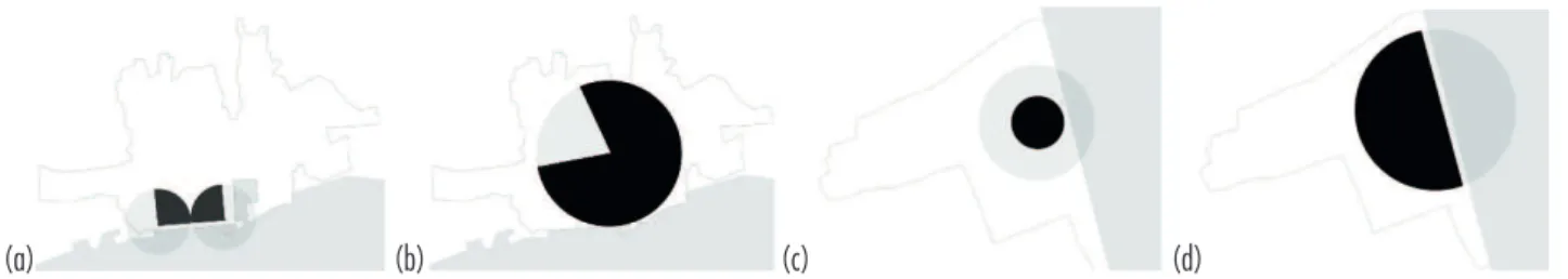
The “Deformed Wheel” pattern of the
integra-tion values was applied to interpret the urban evolution of the coast fishing towns. The theory was adapted to a “Perfect Wheel” illustrative
diagram (Figure 3), permitting to synthesize the axial maps of towns' integration into a “Map of
Wheel Sectors”.
The historic centre of Olhão presents a pattern
of two symmetrical opposite quarters of the DW, composed by two integrators on the perimeter
area of the residential centre, crossed by two ra-dius of each quarter and connected on the
peri-phery by the arches. Although the DW patterns are opposite quarters, the system is balanced by the arches and radius in the periphery of the
nucleus with internal residential areas (Figures
4a, 6a). The urban evolution during the 20th
cen-tury transformed the DW pattern of the historic centre to a complete different one, with arches and radius in the centre, and the absence of them in the periphery, leading to segregated areas on the borderline, revealed in the intelligibility value,
that decreased from 0,33 to 0,17. The urban evo-lution also promoted the displacement of the
in-tegration core to north, imposed by the coastline, centring it and creating almost a complete DWM,
with integration core on the centre and a
poten-tial growing sector to complete de wheel (Figures
4b, 6b). Further urban interventions might create
a new periphery arch that can complete the DWM.
Figure 2 - Urban areas of Olhão and Vila Real de Santo António intelligibility’s scatter plots comparison.
Figure 3 - “Perfect Wheel” illustrative diagram.
The intelligibility’s scatter plot of Olhão’s urban area shows different urban sectors in mixed distribution (a), and of Vila Real de Santo António’s urban area shows different urban sectors in organized distribution (b).
Source: authors.
Components of the “Perfect Wheel” city’s diagram: 1. Most integrated core, 2. Integrated core, 3. Radio, 4. Periphery arch, 5. Arch, 6. Integrated central residency, 7. Segregated central residency, 8. Integrated peripheral residency, and 9. Segregated peripheral residency (according to Hillier, 2005).
Source: authors.
The historic centre of Vila Real de Santo António presents an incomplete DW, only with the central in -tegrated core, without periphery arch or radius. This fact led to a nonexistence of axes that give continuity
to the plan in its expansion (Figures 5a, 6c). Though,
the urban evolution to the west direction, imposed by the coastline limit, developed a central axis perpen -dicular to the coast, implementing a half DW pattern and allowing the appearance of new integrator axis,
periphery arches and residential areas (Figure 5b, 6d).
Figure 4 - Map of the “Deformed Wheel Sectors” of Olhão.
Figure 5 - Map of the “Deformed Wheel Sectors” of Vila Real de Santo António. (a)
(a)
(b) “Deformed Wheel” sectors of Olhão’s historic centre (a) and actual urban area (b). Source: authors.
“Deformed Wheel” sectors of Vila Real de Santo António’s historic centre, corresponding to the 18th century urban plan (a) and the actual urban area (b). Source: authors.
Conclusion
This study focused on two questions: first, if the
model of the “Deformed Wheel” of the Space Syntax Theory can be applied to the urban evolution study
of the coast fishing towns in Algarve; and second, if the urban evolution of the towns influences the
value of intelligibility and consequently the quality of the urban spaces.
The study permitted to conclude that the ap -pliance of the “Deformed Wheel Model” and the “Space Syntax Theory” to the towns’ urban evolution
Mapping the urban form of coastal fishing towns in Algarve
327
Figure 6 - “Deformed Wheel” patterns of Olhão and Vila Real de Santo António towns, for two periods of its urban evolution.
(a) (b) (c)
Corresponding “Deformed Wheel” patterns to the towns’ urbanism: a) symmetrical quarters of the wheel in the historic centre of Olhão, and b) ¾ of the wheel in the actual urban fabric; c) incomplete wheel in the 18th century plan of Vila Real de Santo António; and d) ½ of the wheel in the actual urban fabric. Source: authors.
analysis is possible and it revealed to be an adequate methodological tool for quantitative comparisons.
The morpho-topological study of these towns
also allowed concluding that there is a relation be -tween urban development trends and the value of intelligibility, consequently the quality and percep -tion of the urban space. The irregular fabrics, such
as part of the Olhão’s urbanism, have a vast num-ber of small segments (streets), low integration and low intelligibility of the public spaces: 67% of the streets in the historic centre of Olhão belong to
this scenario (to the range sectors’ from “low inte
-gration and connectivity” to “highest segregation”).
Regular fabrics, such as Vila Real de Santo António’s core, have fewer number of segments but long axes and highest connectivity, highest integration and consequently highest intelligibility, translated in an easy approach and understanding of the public spa
-ce. According to this statement, 31% of streets of
the Vila Real de Santo António’s core belong to the range sectors’ from “low integration and connectivi
-ty” to “highest segregation”. On the other hand, Vila Real de Santo António's urban development,
disre-garding the 18th century urban plan, led to that half
of the streets are integrated in the range sectors'
from “low integration and connectivity” to “highest
segregation” (48%).
These urban evolutions samples, in part suppor
-ted by the economic changes of the fishery industry
to the tourism economy, deteriorate the intelligibi -lity of the traditional urbanism systems, with the decreasing of integration and connectivity syntac -tic values and the increasing of the segregated area, mainly residential.
The appliance of the “Deformed Wheel Model” helped creating a clear idea of towns’ sectors
evolution and to summarize it in patterns’
diagra-ms, raising new hypotheses about intermediate evo -lutionary stages, comparable in future studies with the remaining congeners in the coast of Algarve.
References
Al-Sayed, K., Turner, A., Hillier, B. & Iida, S. (2014). Space Syntax Methodology (2nd ed.). London: University
College London.
Correia, J. H. (2010). O Algarve em Património. Olhão: Gente Singular Editora.
Correia, J. H. (1997). Vila Real de Santo António. Urbanismo e Poder na Política Pombalina (1st ed.).
Porto: Faculdade de Arquitectura da Universidade do Porto.
Folque, F. (1885). Plano hydrographico das barras e por-tos de Faro e Olhão levantado de 1870 a 1873. Lisboa: Direcção Geral dos Trabalhos Geodésicos. Retrieved on 05 November 2016 at http://purl.pt/21968
Folque, F. & Silva, P. (1881). Plano hydrographico da barra e porto do rio Guadiana levantado de 1874 a 1876. Lisboa: Direcção Geral dos Trabalhos Geodésicos. Retrieved on 05 November 2016 at http://purl.pt/1955 Google maps (2015a). Olhão, Portugal. Aerodata International Surveys, Cnes/SpotFigure, DigitalGlobe, GeoEye, IGP/DGRF. Retrieved on September 2015 at http://www.google.com
Google maps (2015b). Vila Real de Santo António, Portugal. Aerodata International Surveys, Cnes/ SpotFigure, DigitalGlobe, GeoEye, IGP/DGRF. Retrieved on September 2015 at http://www.google.com
Hillier, B. (2009). Spatial Sustainability in Cities. Organic Patterns and Sustainable Forms. In Proceedings of the 7th
International Space Syntax Symposium, (K1) (p. 1-20). London: University College London.
Hillier, B. (2005). The art of place and the science of spa-ce. In World Architecture (185), (p. 96-102). London: University College London.
Hillier, B. (1996). Space is the machine. London: Cambridge University Press.
Hillier, B., & Hanson, J. (1984). The social logic of space. London: Cambridge University Press.
Kohlsdorf, M. (1996). A apreensão da forma da cidade. Brasília: Editora UnB.
Martins, A., Castro, C. & Torres, F. (2004). Zona 6. Algarve. In F. Amaral (Ed.), Arquitectura Popular em Portugal (4th.
ed., vol. 2, p. 241-359). Lisboa: Ordem dos Arquitectos. Medeiros, V. (2006). Urbis Brasiliae ou sobre cidades do Brasil (PhD thesis). Faculdade de Arquitectura e Urbanismo, Universidade de Brasília, Brasília.
Navarro, I., Pacheco, M. & Heitor, T. (2015). Plotting the urban growth: Fishing villages at southern Portugal, 1970-2014. In Proceedings of the 10th International Space
Syntax Symposium (p. 54, 1-14). London: University College London.
Pacheco, M., Silva, J., & Heitor, T. (2015). Mapping urban change. The adaptive capacity of coastal fishing villages: Algarve (Portugal) and Paraná (Brazil). In Proceedings of the 10th International Space Syntax Symposium (p. 137,
1-16). London: University College London.
Pacheco, M., & Heitor, T. (2012). How does digital progra-ms help to understand urban evolution. The study case of a Portuguese Mediterranean village. International Journal of Heritage in the Digital Era, 1(1), 65-69. doi: ht-tps://doi.org/10.1260/2047-4970.1.0.65
Ribeiro, S. (2015). Vilas Piscatórias Algarvias (Master thesis). Instituto Superior Técnico, Universidade de Lisboa, Lisboa.
Romba, S. (2015). Evolução Urbana de Olhão. Olhão: Sul, Sol e Sal.
Silva, J., Pacheco, M., & Heitor, T. (2016). Cidades do litoral em rede. Paraná (Brasil) e Algarve (Portugal). In Atas da 5a Conferência Internacional da Rede Lusófona de Morfologia Urbana (p. 435-444). Guimarães: Universidade do Minho.
Silva, J., Pacheco, M., Heitor, T., & Pereira, G. (2015). Paisagens urbanas em transformação: As cidades litorâ-neas de Paranaguá (Brasil) e Faro (Portugal). Uma aná-lise configuracional. In 4a Conferência PNUM. Morfologia
Urbana e os Desafios da Urbanidade (p. 220-239). Brasília: Faculdade de Arquitetura e Urbanismo/Universidade de Brasília.
Turner, A. (2004). Depthmap 4: A researcher's handbook. London: Bartlett School of Built Environment.