www.atmos-chem-phys.net/12/4951/2012/ doi:10.5194/acp-12-4951-2012
© Author(s) 2012. CC Attribution 3.0 License.
Chemistry
and Physics
Influence of medium range transport of particles from nucleation
burst on particle number concentration within the urban airshed
H. C. Cheung1,*, L. Morawska1, Z. D. Ristovski1, and D. Wainwright2
1International Laboratory for Air Quality and Health, Queensland University of Technology, Brisbane, QLD 4001, Australia 2Queensland Department of Environmental Resource and Management, Australia
*now at: Research Center for Environmental Changes, Academia Sinica, Taipei 115, Taiwan
Correspondence to:L. Morawska ([email protected])
Received: 19 September 2011 – Published in Atmos. Chem. Phys. Discuss.: 14 December 2011 Revised: 11 April 2012 – Accepted: 21 May 2012 – Published: 7 June 2012
Abstract.An elevated particle number concentration (PNC) observed during nucleation events could play a significant contribution to the total particle load and therefore to the air pollution in the urban environments. Therefore, a field measurement study of PNC was commenced to investigate the temporal and spatial variations of PNC within the ur-ban airshed of Brisur-bane, Australia. PNC was monitored at urban (QUT), roadside (WOO) and semi-urban (ROC) areas around the Brisbane region during 2009. During the morn-ing traffic peak period, the highest relative fraction of PNC reached about 5 % at QUT and WOO on weekdays. PNC peaks were observed around noon, which correlated with the highest solar radiation levels at all three stations, thus sug-gesting that high PNC levels were likely to be associated with new particle formation caused by photochemical reac-tions. Wind rose plots showed relatively higher PNC for the NE direction, which was associated with industrial pollution, accounting for 12 %, 9 % and 14 % of overall PNC at QUT, WOO and ROC, respectively. Although there was no signif-icant correlation between PNC at each station, the variation of PNC was well correlated among three stations during re-gional nucleation events. In addition, PNC at ROC was sig-nificantly influenced by upwind urban pollution during the nucleation burst events, with the average enrichment factor of 15.4. This study provides an insight into the influence of regional nucleation events on PNC in the Brisbane region and it the first study to quantify the effect of urban pollution on semi-urban PNC through the nucleation events.
1 Introduction
Atmospheric aerosols have been reported to be significantly associated with the alteration of climate forcing and the degradation of visibility, as well as the deterioration of hu-man respiratory and cardiovascular systems (Charlson et al., 1992; Donaldson et al., 1998; Watson 2002). Due to their small size (<0.1 µm), ultrafine particles (UFPs) only con-tribute a very small amount to the total mass of atmospheric particles, however they are most abundant by number (∼70– 90 %) and potentially have a greater impact on human health than the larger particles (<2.5 µm) (Morawska et al., 2008).
(Stolzenburg et al., 2005; Stanier et al., 2004), spatial varia-tions in PNC have also been studied in urban areas in Aus-tralia (Mej´ıa et al., 2008) and in the United States (Hudda et al., 2010). These studies have not examined the impact of regional pollution on PNCs or the influence upwind ur-ban pollution has on PNC downwind during the nucleation events.
This study aimed to examine the effect of regional pollu-tion on PNC in different environments in the Brisbane region. After characterising the spatial variation of PNC in three dif-ferent urban locations, we went on to investigate the influ-ence of regional nucleation on PNC in the same region. Fur-thermore, the impact of urban pollution on PNC downwind from a semi-urban area during a nucleation burst event was also quantified. The results of this study are valuable for as-sessing the impact of nucleation on PNC in an urban envi-ronment.
2 Methods and techniques
2.1 Study design
Field measurements of particles and gaseous pollutants were conducted at three locations in Brisbane in 2009 to represent the urban (1 January to 31 December 2009), roadside (21 May to 31 December 2009) and semi-urban environments (5 February to 31 December 2009).
2.2 The topography and meteorology of the Brisbane region
Brisbane is located at 27′30◦S and 153◦E, at Queensland of Australia. Brisbane city is surrounded by mountains from south to north, and faces the Pacific Ocean to the East. Traf-fic exhaust emissions are the major pollution source affect-ing the central business district (CBD). In addition, the air-craft, ship and industrial emissions are occasionally trans-ported from the lower reaches of the Brisbane River, approx-imately 15–18 km NE of the CBD, by inland sea breezes. General wind patterns in the Brisbane region are governed by land and sea breezes, which are described in more detail by Morawska et al. (1998).
2.2.1 Brisbane CBD (urban general)
The measurements were conducted at the International Labo-ratory of Air Quality and Health (ILAQH), Queensland Uni-versity of Technology (QUT), which is within the Brisbane CBD (Fig. 1). The monitoring site is on the sixth floor of a QUT campus building, located SE of the city centre, with a major highway (the Pacific Motorway) situated along the SW side of the campus. Therefore, the pollution associated with NE winds could be attributed to industrial emissions (from the airport, oil refinery and Port of Brisbane), while the
pol-lution associated with S to NW winds could be attributed to local traffic exhaust emissions.
2.2.2 Woolloongabba (roadside)
The Woolloongabba (WOO) monitoring station is located 3 km south to Brisbane CBD, and it is a part of the South-East Queensland air monitoring network of the Department of En-vironmental Resource and Management (DERM). The mon-itoring station is situated about 5 m from the kerb of Ipswich road, a road with a heavy traffic flow volume of over 40 000, connecting the Southern Brisbane suburbs to the CBD. A rel-atively higher PNC level was expected at this site due to the significant impact of vehicle emission on PNC. In addition, a mutli-storey car park located 10 meters to the West of the station, and large scale road works surrounding the station, could also influence particle pollution levels.
2.2.3 Rocklea (semi-urban)
The Rocklea (ROC) monitoring station is located around 10 km south of the Brisbane CBD and was also operated by the DERM. This station is surrounded by an open area, and the particle concentration was deemed to be free from the in-fluence of local emissions. The major emission sources are from light industrial (Brisbane farmers markets) and residen-tial (domestic cooking) sources in the Rocklea area.
2.3 Measurement techniques
UFP size distribution in the range 4–110 nm was measured at the QUT monitoring site using a Scanning Mobility Particle Sizer (SMPS), which consisted of two parts, an Electrostatic Classifier (EC) (TSI 3080) equipped with a nano-Differential Mobility Analyser (nano-DMA) and a Condensation Particle Counter (CPC) (TSI 3781). Ambient air was drawn through a ∼1 m long conductive tubing connected to the EC. The ratio of the aerosol/sheath air flow for the EC was kept at 1/10 (0.6 to 6 l min−1), and the scan time was five minutes. The size distribution data is then used to calculate PNC for the QUT site. At the WOO and ROC stations, PNC is continuously measured by a water-based CPC (TSI 3781) with a size-cut inlet of 1 nm, while particle mass concentrations of PM2.5 and PM10 are measured by a Tapered Element Oscillating Microbalance (TEOM) in 30-min intervals at each site.
Fig. 1.Map of monitoring sites.
2.4 Data processing and analysis
The raw particle size distribution measurements were trans-formed into 10 min averaged data for figure plotting. The to-tal PNC for QUT was calculated by adding all of the par-ticle counts in each size bin, which had a lower and upper limit of 1 cm−3and 5×105cm−3, respectively (Mej´ıa et al., 2007). Approximately 28 % of the data removed from the database was based on the following criteria (the contribu-tion of each quality control is shown in brackets): (i) if the particle concentration has a zero value (∼2 %); (ii) if the particle concentration is higher than 5×105cm−3(<1 %); (iii) and if data has been collected during instrument mal-function (∼26 %). Since the time resolutions of the particle mass concentration, gaseous and meteorological data pro-vided by the DERM were in 30 min intervals, all measure-ments were transformed into 30 min averaged data for the correlation analysis (Sect. 3.2). Since the PNCs measured at three sites were using SMPS and CPC, to remove the dis-crepancy of these measurement methods, a relative PN con-tribution to total PNC has been used in temporal and cor-relation analysis. Inter-comparison between the PNCs mea-sured by SMPS and CPCs has been shown in Fig. S1; mod-erate correlations have been obtained (r2=0.47–0.81) with slopes of 0.55–0.65. This implies that the method of using PNCs measured by SMPS and CPCs for correlation analysis is justifiable and the ultrafine particles accounted for more than 50 % of the PNC (by using CPC). Correlations between the parameters were tested using the Pearson correlation test, with a 95 % confidence level (p <0.05). The linearity of the tested parameters was indicated by the product of Pearson’s
coefficient,r2, with a perfect linear correlation between two parameters indicated by anr2value close to 1. It should be noted that the PNC data for WOO is missing for the months from January to April due to instrument malfunction.
The back-trajectory of various air masses was calculated by using the HYSPLIT model (Hybrid Single Particle La-grangian Integrated Trajectory, Version 4.9), in order to trace their origin. The meteorological data used for back-trajectory calculations was 1◦×1◦in latitude and longitude. The calcu-lated trajectory analysis provided an indication of which re-gion the air mass came from. For the detail information about the principle and operation of HYSPLIT model was refer-eed to these articles (Draxler and Hess 1997, 1998; Draxler 1999).
3 Results and discussion
Firstly, the variation in PNC within each location was inves-tigated by analysing the diurnal variation together with other measured parameters. Secondly, correlations between PNC for the different locations were examined, along with the in-fluence of wind direction on PNC. Finally, two cases which represented typical regional nucleation events and the trans-port of urban pollution to the downwind semi-urban site were investigated.
3.1 Diurnal variation
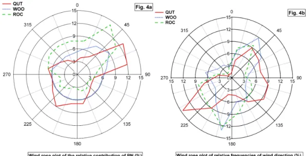
Fig. 2.Average diurnal variation of parameters measured for(a)weekdays and(b)weekends. From bottom to top: (i) relative PNC measured at three sites, together with traffic volumes recorded at QUT; (ii) wind vectors measured at the three sites; and (iii) solar radiation (SR) measured at ROC.
be noted that the measurement periods at each site did not overlap. The general meteorological conditions for week-days and weekends were similar, with SE-winds observed in the morning and NE-winds observed around noon, while solar radiation reached a maximum at noon on all days. In contrast, traffic volumes differed during the weekdays and weekends, such that: (i) traffic volumes were higher during weekdays than weekends; (ii) the daily traffic volume pattern consisted of two peaks during weekdays, one in the morn-ing (∼06:00–07:00 a.m.) and one in the afternoon (around 03:00–06:00 p.m.); and (iii) the daily pattern during week-ends consisted of a wide broader peak.
In Fig. 2a, it can be seen that morning PNC peaks were ob-served both at QUT and WOO. During that period, the mea-sured relative fraction of PNC was found to be nearly 5 % for both sites,, however they were not found at ROC. This
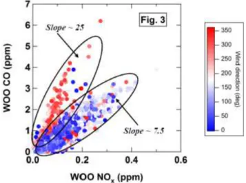
Fig. 3.Scatter plots of COWOOversus NOx, WOO.
One interesting observation was that the influence of traf-fic activity was weak during the afternoon period (∼15:00– 18:00) for both weekdays and weekends, with PNC found to decrease gradually between 14:00–15:00, even though traffic volume remained relatively unchanged. Similar observations were made in the urban area of Helsinki, Finland (Hussein et al., 2004).
3.2 Correlation among measured parameters
A summary of the correlation coefficients (r2)for the mea-sured parameters from the entire period is provided in Ta-ble 1. The lowr values, 0.05< r2<0.19, showed that the PNC at the three sites were not correlated, however PM2.5 and PM10 at WOO and ROC were well correlated (0.60<
r2<0.88). These results implied that the PNC at each site were generally influenced by local sources, such as vehicle exhaust emissions (Morawska et al., 2008), while PM2.5and PM10were influenced by intra-city pollution.
Although there was no correlation between PNC at the three sites, it did appear to be influenced by regional pol-lution during the nucleation events (discussed in Sect. 3.4). PNC at QUT and ROC did not show a significant correlation with primary gaseous pollutants such as CO and NOx, but PNC did show a moderate correlation with CO (r=0.35) and NOx(r=0.47) at WOO. The results observed for QUT are in contrast to those reported by Morawska et al. (1998), where PNC (5–1000 nm) at QUT was reasonably well cor-related with CO (r=0.45) and NOx (r=0.40) and was also influenced by vehicle exhaust emission. This discrep-ancy may be due to the different measurement periods, as the measurements were only conducted during the morning and afternoon peak traffic hours in Morawska et al. (1998). However, a continuous measurement approach was used in the present study, which included a more complex mixture of emissions and a significant contribution to PNC by
nu-cleation process, which may have masked the influence of vehicle exhaust emissions on PNC.
Furthermore, scatter plots (Fig. 3) for carbon monoxide and nitrogen oxide at WOO show the influence of two pol-lution plumes with different CO/NOx ratios as a function of wind direction. The CO/NOxratios for these two groups were∼25 and 7.5, respectively. The first group (ratio 25) was associated with winds from the SW to NW, while the sec-ond group (ratio 7.5) was mainly associated with NE winds. Given that the vehicle exhaust emission ratio in SE Queens-land is about 10 (Cheung et al., 2011), it is likely that the sec-ond group was affected by vehicle exhaust emissions. Since low speed driving induces higher CO/NOxratios than faster driving modes (Holm´en and Niemeier 1997), this could be a result of vehicle emissions from the hospital car park, located 10 m W of WOO. It should be noted that, in the absence of in-situ measurements, this explanation is only speculative.
3.3 Dependence of the particle number concentration on wind direction
The wind rose plots for PNC showed a similar pattern for the three sites (see Fig. 4a), with all three sites affected by both land and sea breezes, which blew from the SW and NE, re-spectively (see Fig. 4b). In general, relatively higher concen-trations were observed in the NE quadrant, being 12 %, 9 % and 14 % for QUT, WOO and ROC, respectively, compared to around 3–6 % for the other three quadrants. This result im-plies that, in addition to the local sources at each site, there was a significant source located in a NE direction of the sites. This is most likely the result of the numerous industrial ac-tivities (i.e. Port of Brisbane, Oil Refinery, and Domestic and International Airports) taking place NE of all three sites, as well as from traffic emissions from the CBD, which is also upwind from WOO and ROC.
3.4 Influences of regional pollution on the particle number concentration
Fig. 4.Wind rose plots of(a)relative PNC contribution at QUT, WOO and ROC;(b)relative frequencies of wind direction.
Table 1.r2calculated between the parameters.
NQUT NWOO NROC PM10 NOx CO PM2.5 PM10 NOx O3 PM2.5 PM10 RAD
(QUT) (WOO) (WOO) (WOO) (WOO) (ROC) (ROC) (ROC) (ROC)
NQUT 1.00 0.05 0.19 0.00 0.02 0.00 0.00 0.00 0.00 0.02 0.00 0.00 0.08
NWOO 1.00 0.12 0.00 0.22 0.12 0.01 0.00 0.03 0.01 0.00 0.00 0.07
NROC 1.00 0.00 0.04 0.03 0.00 0.00 0.01 0.08 0.00 0.00 0.12
PM10 (QUT) 1.00 0.00 0.00 0.12 0.17 0.00 0.01 0.13 0.14 0.00
NOx(WOO) 1.00 0.65 0.05 0.00 0.31 0.02 0.01 0.00 0.00
CO(WOO) 1.00 0.02 0.00 0.20 0.01 0.00 0.00 0.01
PM2.5(WOO) 1.00 0.80 0.03 0.00 0.79 0.60 0.01
PM10(WOO) 1.00 0.00 0.00 0.88 0.80 0.00
NOx(ROC) 1.00 0.27 0.01 0.00 0.06
O3 (ROC) 1.00 0.01 0.00 0.38
PM2.5(ROC) 1.00 0.83 0.00
PM10 (ROC) 1.00 0.00
RAD 1.00
0.75 on 17 July 2009 respectively (withp <0.05). To bet-ter illustrate the correlation of PNCs from different locations (urban and downwind semi-urban areas) during nucleation and non-nucleation events, an example of the PNC scatter-plot obtained during the event and non-event days at QUT and ROC is shown in Fig. S2.
As shown in Fig. 5a, similar temporal variations were ob-served on 17 July 2009, when a nucleation growth event was observed at 10:30. At this time the relative PNC at QUT, WOO and ROC increased from 1.5 % to 8 %, 2 % to 5 % and 1.5 % to 10 % at each station, respectively, before returning to around 1.5 % for each site at approximately 16:00.
In contrast, there were some instances where ther2 was larger than 0.5 for QUT-ROC (r2=0.79), but lower for QUT-WOO (r2<0.01) (e.g. 9 September 2009). In addi-tion, the temporal variation for PNQUT and PNROC were
closely correlated during the period between 10:30–15:30 (see Fig. 5b), while PNWOO did not follow the same trend. This indicates that there was a regional pollution plume that affected QUT and ROC, but not WOO, which was located between the two sites. This may be due to local atmospheric conditions at WOO which suppressed the nucleation, or it may be the result of two individual nucleation events that occurred at QUT and ROC simultaneously. Further analy-sis was required in order to explain this phenomenon, in-cluding data for gaseous pollutants, meteorological condi-tions, PM2.5and PM10which will be discussed in following section.
3.4.1 Comparison of the two case studies
Fig. 5.Time series plot of parameters measured on(a)17 July 2009 and(b)9 September 2009. From bottom to top: (i) relative PNC measured at QUT, WOO and ROC; (ii) wind vectors for QUT, WOO and ROC; and (iii) solar radiation (SR) at ROC.
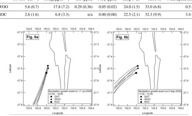
nucleation events (see Fig. 6a–b). The results suggest that the air masses at each site originated from the same region on both occasions, which means that the absence of a nucle-ation event at WOO on 9 September 2009 is likely to be the result of other variable factors such as local emission sources and/or meteorological conditions.
In order to further investigate the similarities and differ-ences between these two cases, average PNC and PM10, as well as gaseous pollutants such as CO and NOx, and meteo-rological conditions including temperature, relative humidity and wind speed, were compared for WOO and ROC (see Ta-ble 3). Overall, no significant differences in temperature or relative humidity were observed, although a relatively lower wind speed was observed at WOO (∼1 ms−1)compared to that of ROC (∼3–4 ms−1)during both events. The tempera-ture differences during those events at WOO and ROC were small, implying that the impacts of height of mixing layer on
both locations were similar. This observation (with highr2
(QUT-ROC) and relatively lowr2(QUT-WOO),r2 (WOO-ROC)) was also found on 30 May, 8 June, 8 August and 16 October 2009. For gaseous pollutants, the mixing ratios for NOxat WOO and ROC remained the same for both events, while a relatively higher mixing ratio of 0.29 ppm for CO was observed at WOO on 9 September 2009, compared to 0.19 ppm on 17 July 2009. A relatively higher CO/NOx ra-tio of∼5.8 was also observed at WOO on 9 September 2009 compared to∼3.8 on 17 July 2009.
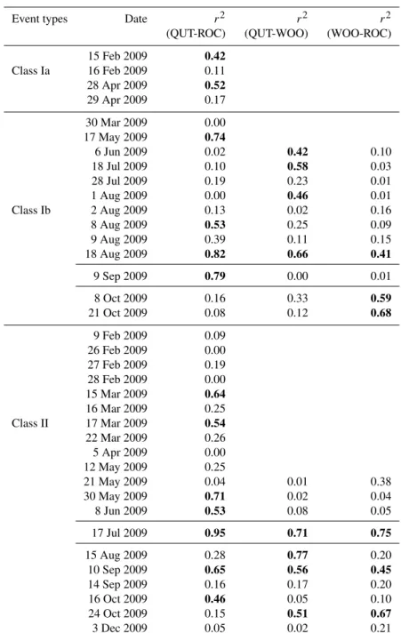
Table 2.Ther2values for PNC at QUT, WOO and ROC during nucleation growth events (r2values>0.4 are bolded). Nucleation events were classified into Class Ia/b where the particle growth rate can be determined and Class II where the banana shape still observable, but the data fluctuates to such an extent that formation rate calculation is impractical. More detailed explanation of class type can be found in Cheung et al. (2011).
Event types Date r2 r2 r2
(QUT-ROC) (QUT-WOO) (WOO-ROC)
15 Feb 2009 0.42
Class Ia 16 Feb 2009 0.11 28 Apr 2009 0.52
29 Apr 2009 0.17
30 Mar 2009 0.00 17 May 2009 0.74
6 Jun 2009 0.02 0.42 0.10
18 Jul 2009 0.10 0.58 0.03
28 Jul 2009 0.19 0.23 0.01
1 Aug 2009 0.00 0.46 0.01
Class Ib 2 Aug 2009 0.13 0.02 0.16
8 Aug 2009 0.53 0.25 0.09
9 Aug 2009 0.39 0.11 0.15
18 Aug 2009 0.82 0.66 0.41
9 Sep 2009 0.79 0.00 0.01
8 Oct 2009 0.16 0.33 0.59
21 Oct 2009 0.08 0.12 0.68
9 Feb 2009 0.09 26 Feb 2009 0.00 27 Feb 2009 0.19 28 Feb 2009 0.00 15 Mar 2009 0.64
16 Mar 2009 0.25 Class II 17 Mar 2009 0.54
22 Mar 2009 0.26 5 Apr 2009 0.00 12 May 2009 0.25
21 May 2009 0.04 0.01 0.38
30 May 2009 0.71 0.02 0.04
8 Jun 2009 0.53 0.08 0.05
17 Jul 2009 0.95 0.71 0.75
15 Aug 2009 0.28 0.77 0.20
10 Sep 2009 0.65 0.56 0.45
14 Sep 2009 0.16 0.17 0.20
16 Oct 2009 0.46 0.05 0.10
24 Oct 2009 0.15 0.51 0.67
3 Dec 2009 0.05 0.02 0.21
Table 3a.Average values of measured parameters of WOO and ROC from 08:00–16:00 on 17 Jul 2009. A standard deviation showed in bracket.
PN (103cm−3) PM10(µg m−3) CO (ppm) NOx(ppm) Temp (◦C) RH (%) Wind Speed (ms−1)
WOO 8.3 (3.9) 13.6 (3.5) 0.19 (0.15) 0.05 (0.02) 17.7 (1.8) 47.8 (5.8) 1.0 (0.5)
Table 3b.Average values of measured parameters of WOO and ROC from 08:00–16:00 on 9 Sep 2009. A standard deviation showed in bracket.
PN (103cm−3) PM10(µg m−3) CO (ppm) NOx(ppm) Temp (◦C) RH (%) Wind Speed (ms−1)
WOO 5.6 (0.7) 17.8 (7.2) 0.29 (0.36) 0.05 (0.02) 24.0 (1.5) 33.0 (6.8) 0.5 (0.1)
ROC 2.6 (1.6) 6.8 (3.3) n/a 0.00 (0.00) 22.5 (2.1) 32.3 (9.9) 3.4 (1.0)
Fig. 6.Back-trajectories for the first two hours of each event:(a)17 Jul 2009 and(b)9 Sep 2009.
therefore suppressing new particle formation (Kerminen et al., 2001). In our previous study (Jayaratne et al, 2011), it has been shown that an increase of PM10concentration in the environment leads to a sharp decrease in the number of ultra-fine particles. Therefore, the relatively higher particle mass concentration of WOO on 9 September 2009, which is in-dicative of more pre-existing particles. This explains the sup-pression of the nucleation process at WOO on this day. Be-side the influence of condensation sink on the suppression of nucleation, the coagulation scavenging may be another factor which removed the freshly formed particles in this case.
3.5 Influence of upwind pollution on the particle numberconcentration in the downwind area
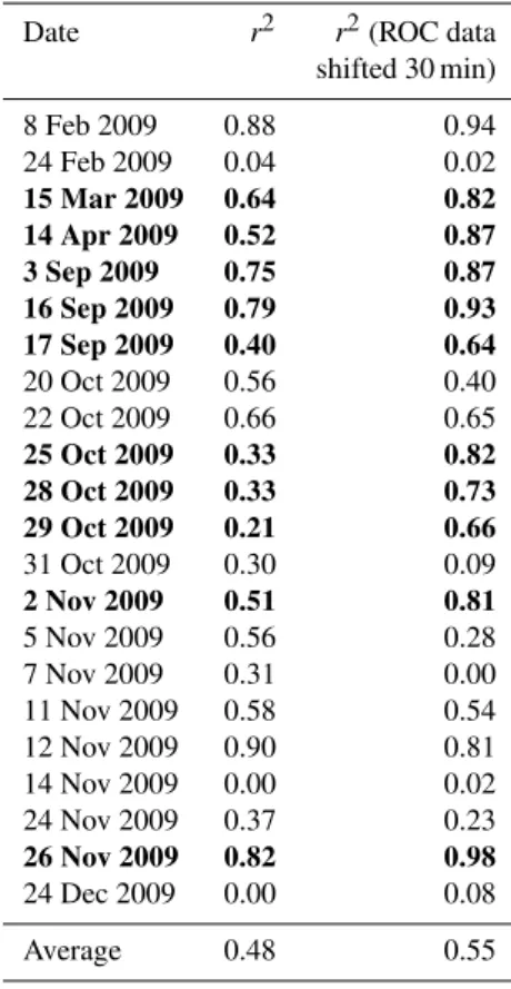
In addition to the influence of regional pollution on PNC at each site, upwind pollution from a NE direction was also found to affect PNC. In order to characterise the influence of nucleation burst events on air quality downwind from larger pollution sources, we analysed the data from Cheung et al. (2011), based on 22 nucleation burst events that oc-curred at QUT during 2009, all of which were associated with NE winds that originated from the same direction as the Brisbane Airport, Oil Refinery and Port of Brisbane. Ta-ble 4 shows the Pearson’s coefficient for PNC at QUT and ROC during the nucleation burst events. Since it takes about 30 min for air masses to move from QUT to ROC (assuming
an average wind speed of∼5 ms−1during the event period), ther2values were also calculated based on data from 30 min later at ROC (e.g. 12:30 data from QUT was compared with 13:00 data for ROC).
Fig. 7.Time series plot of parameters measured on 25 Oct 2009. From bottom to top: (i) number concentration of nucleation and Aitken modes particles; (ii) relative particle number concentration measured at QUT and ROC; (iii) wind vectors at QUT and ROC; and (iv) solar radiation (SR) at Rocklea.
Fig. 8. Back-trajectories calculated for the burst events on 25 Oct 2009.
To further evaluate the impact of the nucleation burst events on the PNC in the semi-urban area of ROC, we de-termined the enrichment factor of PNC by calculating the ra-tio of maximum to minimum PNC during the period 08:00– 16:00. On 25 Oct 2009, PNC increased to about 11.6 times higher than the minimum PNC, which indicates that the
ur-ban/industrial pollution plume had a significant effect on PNC in the semi-urban area. The enrichment factor for other nucleation burst event days are listed in Table S1, in the Sup-plement. The average enrichment factor for PNC at ROC as a result of upwind urban pollution during the nucleation burst events was 15.4.
4 Conclusions
Table 4.Ther2values for PNC at QUT and ROC during nucle-ation burst events. Only data observed between 08:00-16:00 has been used (shiftedr2values larger than originalr2, and the values ≥0.4 are bolded).
Date r2 r2(ROC data shifted 30 min)
8 Feb 2009 0.88 0.94 24 Feb 2009 0.04 0.02
15 Mar 2009 0.64 0.82 14 Apr 2009 0.52 0.87 3 Sep 2009 0.75 0.87 16 Sep 2009 0.79 0.93 17 Sep 2009 0.40 0.64
20 Oct 2009 0.56 0.40 22 Oct 2009 0.66 0.65
25 Oct 2009 0.33 0.82 28 Oct 2009 0.33 0.73 29 Oct 2009 0.21 0.66
31 Oct 2009 0.30 0.09
2 Nov 2009 0.51 0.81
5 Nov 2009 0.56 0.28 7 Nov 2009 0.31 0.00 11 Nov 2009 0.58 0.54 12 Nov 2009 0.90 0.81 14 Nov 2009 0.00 0.02 24 Nov 2009 0.37 0.23
26 Nov 2009 0.82 0.98
24 Dec 2009 0.00 0.08
Average 0.48 0.55
are useful for environmental management and assessment in regard to PNC.
Supplementary material related to this article is available online at:
http://www.atmos-chem-phys.net/12/4951/2012/ acp-12-4951-2012-supplement.pdf.
Acknowledgements. This project was supported by the Australian Research Council and Queensland Transport through Linkage Grant LP0882544. We would also like to thank the Department of Environmental Resource and Management, Queensland for providing the air monitoring data; and the Queensland Bureau of Meteorology for providing the meteorological data.
Edited by: C. K. Chan
References
Charlson, R. J., Schwartz, S. E., Hales, J. M., Cess, R. D., Coaklev Jr., J. A., Hansen, J. E., and Hofmann, D. J.: Climate forcing by anthropogenic aerosols, Science, 255, 423–430, 1992.
Cheung, H. C., Morawska, L., and Ristovski, Z. D.: Observation of new particle formation in subtropical urban environment, At-mos. Chem. Phys., 11, 3823–3833, doi:10.5194/acp-11-3823-2011, 2011.
Donaldson, K., Li, X. Y., and MacNee, W.: Ultrafine (nanome-tre) particle mediated lung injury, J. Aerosol. Sci., 29, 553–560, 1998.
Draxler, R. R.: HYSPLIT4 user’s guide, NOAA Tech. Memo. ERLARL-230, NOAA Air Resources Laboratory, Silver Spring, MD, 1999.
Draxler, R. R. and Hess, G. D.: Description of the HYSPLIT 4 mod-eling system. NOAA Tech. Memo. ERLARL-224, NOAA Air Resources Laboratory, Silver Spring, MD, 1997.
Draxler, R. R. and Hess, G. D.: An overview of the HYSPLIT 4 modeling system of trajectories, dispersion, and deposition, Aust. Meteorol. Mag., 47, 295–308, 1998.
Holm´en, B. A. and Niemeier, D. A.: Characterizing the effects of driver variability on real-world vehicle emissions, Transport Res. D-Tr. E., 3, 117–128, 1997.
Hudda, N., Cheung, K., Moore, K. F., and Sioutas, C.: Inter-community variability in total particle number concentrations in the eastern Los Angeles air basin, Atmos. Chem. Phys., 10, 11385–11399, doi:10.5194/acp-10-11385-2010, 2010.
Hussein, T., Puustinen, A., Aalto, P. P., M¨akel¨a, J. M., H¨ameri, K., and Kulmala, M.: Urban aerosol number size distributions, Atmos. Chem. Phys., 4, 391–411, doi:10.5194/acp-4-391-2004, 2004.
Hussein, T., Martikainen, J., Junninen, H., Sogacheva, L., Wagner, R., Dal Maso, M., Riipinen, I., Aalto, P. P., and Kulmala, M.: Observation of regional new particle formation in the urban at-mosphere, Tellus, 60B, 509–521, 2008.
Jaffe, D., Mckendry, I., Anderson, T., and Price, H.: Six “new” episodes of trans-Pacific transport of air pollutants, Atmos. Env-iron., 37, 391–401, 2003.
Jayaratne, E. R., Johnson, G. R., McGarry, P., Cheung, H. C. and Morawska, L.: Characteristics of airborne ultrafine and coarse particles during the Australian dust storm of 23 September 2009, Atmos. Environ., 45, 3996–4001, 2011.
Kerminen, V.-M., Pirjola, L., and Kulmala, M.: How sig-nificantly does coagulational scavenging limit atmospheric particle production?, J. Geophys. Res., 106, 24119–24125, doi:10.1029/2001JD000322, 2001.
Mazaheri, M., Johnson, G. R., and Morawska, L.: Particle and Gaseous Emissions from Commercial Aircraft at Each Stage of the Landing and Takeoff Cycle, Environ. Sci. Technol., 43, 441– 446, 2009.
Mej´ıa, J. F., Wraith, D., Mengersen, K., and Morawska, L.: Trends in size classified particle number concentration in subtropical Brisbane, Australia, based on a 5 year study, Atmos. Environ., 41, 1064–1079, 2007.
Mej´ıa, J. F., Morawska, L., and Mengersen, K.: Spatial variation in particle number size distributions in a large metropolitan area, Atmos. Chem. Phys., 8, 1127–1138, doi:10.5194/acp-8-1127-2008, 2008.
Morawska, L., Ristovski, Z., Jayaratne, E. R., Keogh, D. U., and Ling, X.: Ambient nano and ultrafine particles from motor ve-hicle emissions: Characteristics, ambient processing and impli-cations on human exposure, Atmos. Environ., 42, 8113–8138, 2008.
Pey, J., Querol, X., Alastuey, A., Rod`aiguez, S., Putaud, J. P., and Van Dingenen, R.: Source apportionment of urban fine and ultra-fine particle number concentration in a Western Mediterranean city, Atmos. Environ., 43, 4407–4415, 2009.
Qian, S., Sakurai, H., and McMurry, P. H.: Characteristics of re-gional nucleation events in urban East St. Louis, Atmos. Envi-ron., 41, 4119–4127, 2007.
Sinha, P., Hobbs, P. V., Yokelson, R. J., Christian, T. J., Kirchstetter, T. W., and Bruintjes, R.: Emissions of trace gases and particles from two ships in the southern Atlantic Ocean, Atmos. Environ., 37, 2139–2149, 2003.
Stanier, C. O., Khlystov, A. Y., and Pandis, S. N.: Nucleation events during the Pittsburgh air quality study: description and relation to key meteorological, gas phase and aerosol parameters, Aerosol Sci. Tech., 38, 253–264, 2004.
Stolzenburg, M. R., McMurry, P. H., and Sakurai, H.: Growth rates of freshly nucleated atmospheric particles in Atlanta, J. Geophys. Res., 110, D22S05, doi:10.1029/2005JD05935, 2005.