Article
NOVEL APPROACH TO IMPROVE GEOCENTRIC TRANSLATION
MODEL PERFORMANCE USING ARTIFICIAL NEURAL NETWORK
TECHNOLOGY
Nova abordagem para melhorar o desempenho do modelo de translação
geocêntrica utilizando tecnologia de redes neurais artificiais
Yao Yevenyo Ziggah 1, 2
Hu Youjian 1
Prosper Basommi Laari 3, 4
Zhenyang Hui 1
1Faculty of Information Engineering, Department of Surveying and Mapping, China University of
Geosciences, Wuhan, 430074, P. R. China. Email: [email protected]; [email protected].
2Faculty of Mineral Resources Technology, Department of Geomatic Engineering, University of Mines
and Technology, Tarkwa, Ghana. Email: [email protected]; [email protected].
3Department of Environment and Resource Studies, University for Development Studies, Wa-Ghana.
Email: [email protected].
4School of Environmental Science, China University of Geosciences, Wuhan, 430074, P. R. China
Abstract:
Geocentric translation model (GTM) in recent times has not gained much popularity in coordinate transformation research due to its attainable accuracy. Accurate transformation of coordinate is a major goal and essential procedure for the solution of a number of important geodetic problems. Therefore, motivated by the successful application of Artificial Intelligence techniques in geodesy, this study developed, tested and compared a novel technique capable of improving the accuracy of GTM. First, GTM based on official parameters (OP) and new parameters determined using the arithmetic mean (AM) were applied to transform coordinate from global WGS84 datum to local Accra datum. On the basis of the results, the new parameters (AM) attained a maximum horizontal position error of 1.99 m compared to the 2.75 m attained by OP. In line with this, artificial neural network technology of backpropagation neural network (BPNN), radial basis function neural network (RBFNN) and generalized regression neural network (GRNN) were then used to compensate for the GTM generated errors based on AM parameters to obtain a new coordinate transformation model. The new implemented models offered significant improvement in the horizontal position error from 1.99 m to 0.93 m.
Keywords: Geocentric translation model, Backpropagation neural network, Radial basis function neural network, Generalized regression neural network, Coordinate transformation.
Resumo:
de coordenadas é um procedimento essencial na maioria dos problemas geodésicos. Entretanto, motivado pelo sucesso na aplicação de técnicas de Inteligência Artificial na Geodésia, este estudo testou e comparou uma nova técnica capaz de aumentar a exatidão do modelo GTM. Inicialmente, o GTM é definido com parâmetros oficiais (OP) e novos parâmetros determinados usando a média aritmética (AM) foram aplicados na transformação de coordenadas do datum global WGS84 para o datum local Accra. Com base nesses resultados, os novos parâmetros da média aritmética (AM) alcançaram um erro posicional horizontal máximo de 1.99m, em comparação com 2.75m alcançado pelos parâmetros oficiais (OP). De maneira similar, a tecnologia de redes neurais artificiais dos modelos BPNN (BackPropagation Neural Network), RBFNN (Radial Basis Function Neural Network) e GRNN (Generalized Regression Neural Network) foram então utilizadas para compensar os erros do modelo GTM com os parâmetros baseados na média aritmética (AM) para se obter um novo modelo de transformação de coordenadas. Os novos modelos implementados apresentaram uma melhora significativa no erro posicional horizontal de 1.99m para 0.93m.
Palavras-chave: Modelo de translação geocêntrica, modelo neural BPNN, modelo neural RBFNN, modelo neural GRNN, Transformação de coordenadas.
1. Introduction
Over the past years, the development of numerical techniques that can transform coordinates between global to local datums and vice versa or within the same reference system has increasingly become a major focus of the geodetic community. As an example, three dimension (3D) conformal models such as Bursa-Wolf, Molodensky-Badekas, Veis, 3D affine model have been developed and widely used in coordinate transformation (Rapp, 1993; Featherstone, 1997; Deakin, 1998, 2006; Andrei, 2006; Ayer and Fosu, 2008; Paláncz et al., 2010; Zeng, 2010; Dzidefo, 2011; Haasdyk and Janssen, 2011; Ziggah et al., 2013; Solomon, 2013; Lehman, 2014). Other methods like 2D conformal model, 2D affine model, multiple regression, Abridged Molodensky, Thomson-Krakiwsky, Vanicek and Wells and Hotine model have also been applied in coordinate transformation (Thomson, 1976; Abd-Elmotaal and Ei-Tokhey, 1997; Newsome and Harvey, 2003; Fraser and Yamakawa, 2004; Molnár and Timár, 2005; Başçiftçi et al., 2006; Karunaratne, 2007; Ayer and Tiennah, 2008; Dawod et al., 2010).
Additionally, with the advancement in satellite positioning technology, several new procedures have been put forth to carry out coordinate transformation with the primary objective of improving transformation accuracy. In practice, the most common alternatives could be categorised into artificial intelligence technology (Zaletnyik, 2004; Lin and Wang, 2006; Tierra et al., 2008; Tierra et al., 2009; Gullu, 2010; Turgut, 2010; Gullu et al., 2011; Yilmaz and Gullu, 2012; Mihalache, 2012; Tierra and Romero, 2014), partitioning methods (Lippus, 2004; Kheloufi, 2006), Ill-posed approach (Zeng, 2010; Zeng and Yi, 2010; Ge and Wu, 2012), least squares algorithms (Felus and Schaffrin, 2005; Acar et al., 2006a, 2006b; Rey-Jer and Hwa-Wei, 2006; Akyilmaz, 2007; Janicka, 2011; Mahboub, 2012), quaternions approach (Shen et al., 2006; Jitka, 2011; Zeng and Yi, 2011), dynamic datum transformation approach (Soler, 1998; Soler and Marshall, 2003; Soler and Snay, 2003; Stanaway, 2008; Haasdyk and Janssen, 2011), Procrustes algorithm (Grafarend and Awange, 2003; Zeng, 2015) to mention but a few. It is important to note that coordinate transformation has been chiefly dominated by the above mentioned methods due to their achievable accuracy.
Defence and Mapping Agency (DMA) now National Geospatial-Intelligence Agency (NGA), USA. This is due to the low transformation accuracy usually obtained by the GTM as compared to other coordinate transformation procedures. The low accuracy is mostly attributed to a defect in the GTM because it only applies the three-dimensional origin shift with no regard for rotations and scale changes between the reference systems (Featherstone, 1997). Moreover, the heterogeneous nature of the local geodetic network also contributes to the inability of the GTM to achieve higher transformation accuracy. This is because local geodetic networks are established through classical surveying techniques of triangulation, traverse, and astronomical observations (Andrei, 2006; Tierra et al., 2008). Hence, unwanted distortions are introduced into the local geodetic network (Vanicek and Steeves, 1996) which could not be more absorbed by the GTM.
On the contrary, GTM coordinate transformation results could be applied in situations without high accuracy demand (Featherstone, 1997; Newsome and Harvey, 2003). For example, in field surveying works such as reconnaissance; in Geographic Information System (GIS) data collection for database generation; topographic mapping, farm boundary surveys and many others. Besides, it could be used to transform thematic type data such as vegetation, soil type, hydrology, environment, demography, health, economic and geology where the accuracy is not critical. Generally, the translation parameters used by the GTM are mainly obtained from Abridged Molodensky, Bursa-Wolf, and Molodensky-Badekas model (Featherstone, 1997; Newsome and Harvey, 2003). However, Featherstone, (1997) argued that GTM which solely depends on the translation parameters would produce inconsistent results due to different translation values obtained from the similarity models. Therefore, a good representation about the characteristics of the coordinates data will be based on the original shift determined using the arithmetic mean (AM) technique.
This study applied the AM method to first determine the GTM translation parameters required in transforming coordinates between Ghana’s Accra datum based on War Office 1926 ellipsoid and World Geodetic System 1984 (WGS84) ellipsoid. Due to the attainable accuracy of the GTM, the residuals which remain after comparing transformed coordinates to the existing coordinates are mostly on a high level. Therefore, actuated by the effective use of artificial intelligence (AI) techniques in surveying and mapping, this study proposed a novel approach known as the Artificial Neural Network-Error Compensation Model (ANN-ECM). The ANN methods utilized in this study for the proposed model formulation include the backpropagation neural network (BPNN), radial basis function neural network (RBFNN) and generalized regression neural network (GRNN). These ANN-ECMs developed were tested for their efficiency in improving GTM performance. Also, the ANN-ECMs were compared with GTM transformed coordinates based on the arithmetic mean (AM) calculated parameters and the Official Parameters (OP) determined by the then DMA now NGA for use in Ghana.
2. Study Area and Data Source
The study area is Ghana located in West Africa. It is bordered on the North by Burkina Faso, Ivory Coast to the West, Togo to the East and Gulf of Guinea to the South. Ghana uses a horizontal datum known as the Accra datum for its geodetic activities. The reference surface of the Accra datum is the War Office 1926 ellipsoid suggested by the British War Office, with semi-major axis a = 6378299.99899832 m, semi minor axis b = 6356751.68824042 m, flattening f = 1/296, and Gold Coast feet to meter conversion factor of 0.304799706846218 respectively (Ayer, 2008; Ayer and Fosu, 2008). For the estimation of planimetric coordinates the Transverse Mercator projection system is used (Mugnier, 2000; Poku-Gyamfi and Hein, 2006). It is important to note that, the coordinate system used to indicate positions of features on all survey maps in Ghana is the projected grid coordinates of Easting and Northing derived from the Transverse Mercator projection.
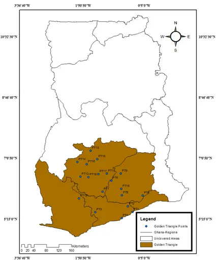
With the advent of modern positioning technologies, the Ghana Survey and Mapping Division of Lands Commission, through the Land Administration Project (LAP) sponsored by the World Bank embarked on the establishment of a new geodetic reference network referred to as the Golden Triangle (Figure 1).
Figure 1: Study area showing geographic data distribution
Then, all other stations were determined from those 5 initial stations (Kotzev, 2013). This demand-led project has been divided into phases, with the first phase covering five out of the ten regions in Ghana namely; Ashanti, Greater Accra, Western, Central and Eastern. These regions form the completed first phase of the new geodetic reference network (Golden Triangle) as shown in Figure 1. The choice of the five out of ten administrative regions in Ghana for the first phase of the project was due to the fact that most of the natural resources such as gold, bauxite, manganese, oil, timber, cocoa, diamond and many others found in the country are situated in these regions. Hence, contributing significantly to the economic growth of Ghana.
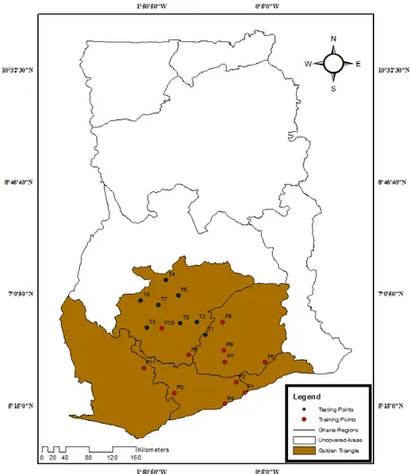
In this study, project data from the Ghana Survey and Mapping Division of Lands Commission in its on-going Land Administration Project (LAP) sponsored by the World Bank was applied. Two sets of 19 common points in both the local War Office (ɸ,λ,h)WAR and global WGS84 (ɸ,λ,h)WGS84 system which form the Golden Triangle were provided. Here, ɸ is the latitude, λ is
the longitude and h is the height of the reference ellipsoid.
3. Methods
3.1 Geocentric Translation Model
The Geocentric Translation Model (GTM) was applied in this study to estimate transformation parameters for transforming coordinates from WGS84 datum to Accra datum. The GTM is defined in Equation 1 (Featherstone, 1997; Newsome and Harvey, 2003; Solomon, 2013) as
where (X, Y, Z)global is the global rectangular coordinates based on the WGS84 and (X, Y, Z)local
is the local rectangular coordinates based on Ghana War Office 1926 ellipsoid. In order to estimate the unknown transformation parameters (∆X, ∆Y, ∆Z), the most widely used arithmetic mean approach was applied. Detailed description about the procedure is given in Sect. 3.3 at step 2.
3.2 Artificial Neural Network
comprises of training examples with each example having a pair of input vector and desired output data. In the BPNN and RBFNN model, a single hidden layer including input layer and output layer was constructed. While four layers thus input layer, pattern layer, a summation layer, and output layer formed the GRNN model architecture. The construction steps of the proposed approach termed as Artificial Neural Network-Error Compensation Model (ANN-ECM), more specifically BPNN-ECM, RBFNN-ECM and GRNN-ECM, their input and output element space and the models calculation results will be the focus of this paper. The detailed methodology is given in Sect. 3.3, respectively.
3.3 Proposed Approach
Several authors have argued that most coordinate transformation models cannot completely account for the distortions existing in the local geodetic networks (Featherstone, 1997; Newsome and Harvey, 2003; Tierra et al., 2008). Instead, most researchers have resorted to the use of Artificial Intelligence (AI) techniques. This is because AI is capable of minimizing the influence of local distortions in the transformation process thereby improving transformation performance. With this in mind, the present authors propose a new approach to compensate for the errors generated by the GTM. The specific detail on how the new approach was developed and implemented is presented as follows.
Step 1: Transforming geodetic coordinates to rectangular coordinates
A prerequisite step in the coordinate transformation process was to transform the geodetic coordinates of common points in both WGS84 datum and Accra datum into rectangular coordinates form. Hence, all the 19 geodetic coordinates of common points represented as (ɸ,λ,h)WGS84 and (ɸ,λ,h)WAR applied in this study were first transformed into rectangular coordinates using Equation 2 (Schofield, 2001; Leick, 2004).
Here, N is the radius of curvature in the prime vertical; e2 is the first eccentricity of the reference
ellipsoid; f is the flattening of the reference ellipsoid; h is the height of the reference ellipsoid; a is the semi-major axis of the reference ellipsoid and (,)is the geodetic latitude and geodetic longitude respectively. The transformed rectangular coordinates for the WGS84 datum and Accra datum using Equation 2 are designated in this study as (X, Y, Z)WGS84 and (X, Y, Z)WAR,
respectively.
Step 2: Determining the transformation parameters
In this step, out of the 19 rectangular coordinates of common points, 11 (X, Y, Z)WGS84 and (X,
Y, Z)WAR were selected as reference points set P = (P1, P2, … P11) and applied to determine the
set T = (T1, T2,… T8) for the entire model validation denoted as (X, Y, Z)TEST WGS84 and (X, Y,
Z)TEST WAR. It must be known that these test points were independent of the transformation
process when the GTM parameters were determined. In order to obtain the translation parameters, Equation 3 was applied to estimate the individual translation vectors (∆X, ∆Y, ∆Z) of the 11 common points. Finally, the GTM transformation parameters were determined by simply finding the arithmetic mean (AM) (Equation 4) of the translation vector values (∆X, ∆Y, ∆Z) estimated between the common points.
Where, i = 1, 2, 3,…,n (n is the number of observations used = 11), X, Y, Z are the arithmetic mean of ∆X, ∆Y, ∆Z estimated values between the common points coordinates (War – WGS84).
Step 3: Applying the transformation parameters
The arithmetic mean translation vectors (X,Y,Z) determined in Step 2 becomes the transformation parameters. These parameters were then applied in Equation 5 to transform the 11 (X, Y, Z)WGS84 into the Accra datum. These newly 11 transformed rectangular coordinates are
denoted in this study as (X, Y, Z)NEW WAR. Similarly, the transformation parameters (∆X, ∆Y, ∆Z)
were also applied to transform the 8 independent test points (X, Y, Z)TEST WGS84 into the Accra
datum using Equation 6. These 8 transformed test coordinates is represented in this work as (X, Y, Z)TEST NEW WAR.
Where, i = 1, 2, 3,…, 11 in Equation 5 and i = 1, 2, 3,…, 8 in Equation 6 corresponding to the number of common points used in the respective equations.
Step 4: Error estimation
estimated in Step 3 deviate from the measured Accra datum coordinates. To achieve this, Equation 7 was applied to the 11 transformed coordinates.
Here, (X, Y, Z)WAR and (X, Y, Z)NEW WAR are respectively the measured Accra datum coordinates
and the GTM transformed coordinates for the 11 points while (ex, ey, ez) indicate the estimated
errors between them. In this step, the number of common points are 11 hence in Equation 7, i = 1, …, 11.
Step 5: Establishing the ANN-Error compensation model (ANN-ECM)
The estimated errors (ex, ey, ez) and GTM transformed coordinates (X, Y, Z)NEW WAR constituted
the learning examples. Here, (X, Y, Z)NEW WAR obtained from the GTM (Step 3) was used as the
input data and (ex, ey, ez) as the target elements in the ANN model development. The input and
output data was used in training the three ANN models namely BPNN, RBFNN and GRNN. Before the training process began, data normalization was first performed. The essence is to ensure constant variability in the datasets thereby improving convergence speed; in so doing it reduces the chances of getting stuck in local minima. In this study, the input data were normalized in the range [0, 1] by Equation 8 (Konaté et al., 2015)
where X is the scaled value, xi is the current value of the input data, xmin is the minimum value of
x, and xmax is the maximum value of x respectively.
The next step was to train the BPNN, RBFNN and GRNN using the input and target data to generate an input-output mapping relationship. The BPNN was trained using Levenberg-Marquardt algorithm (Nocedal and Wright, 2006) while RBFNN was trained using gradient descent rule (Fernandez-Redondo et al., 2006). When the training process of BPNN, RBFNN and GRNN is over, a calculation model for the GTM generated errors for the study area is developed. Therefore, the GTM errors of any position within the study area can be calculated by the optimum BPNN, RBFNN and GRNN models. That is, for any GTM transformed coordinates within the study area, one takes the transformed values into the trained BPNN, RBFNN and GRNN models and then calculates the errors. This optimum BPNN, RBFNN, GRNN predictions compensate for the GTM generated errors. Hence, the ANN-ECMs are formed.
Step 6: Transforming coordinates with ANN-ECM
When the ANN-ECMs were formed in Step 5, there was the need to test their efficiency. Here, the (X, Y, Z) TEST NEW WAR (Step 3) points were used as the test input data into the BPNN-ECM,
RBFNN-ECM and GRNN-ECM respectively. The final transformed coordinates was then estimated by adding the estimated error from the BPNN-ECM, RBFNN-ECM and GRNN-ECM to the (X, Y, Z) TEST NEW WAR using Equation 9. This means that for any GTM transformed
Here, (X, Y, Z)TRANS WAR is the ANN-ECMs transformed coordinates and (ex new, ey new, ez new) are the estimated errors by the optimum BPNN, RBFNN and GRNN schemes developed in Step 5.
Step 7: Transforming rectangular coordinates to geodetic coordinates
Since Ghana uses the 2D projected grid coordinate system for its surveying and mapping related activities, the (X, Y, Z)TRANS WAR was transformed into geodetic coordinates using Bowring
Inverse Equation stated in (Gerdan and Deakin, 1999). This will make it possible for the geodetic coordinates to be projected onto the Transverse Mercator projection to obtain projected grid coordinate in Eastings (E) and Northings (N). The new projected coordinates was then compared with the measured projected coordinates to ascertain the proposed models accuracy performance.
4. Accuracy Analysis
In this study, the mean squared error (MSE) (Equation 10) was used as the criterion for determining the optimum BPNN, RBFNN and GRNN schemes.
Additionally, in order to compare the test projected grid coordinate results obtained by the GTM and ANN-ECMs to the measured projected grid coordinates, horizontal error (HE), arithmetic mean error (Mean) and standard deviation (SD) were utilized. Their mathematical representations are given in Equations 11 to 13.
5. Results and Interpretation
5.1 Geocentric Translation Model
In order to develop the Artificial Neural Network-Error Compensation Models (ANN-ECMs), there was the need to first carry out coordinate transformation using the geocentric translation model (GTM). To achieve this, transformation parameters determined based on the arithmetic mean (AM) (Section 3.3 (Step 2)) was used in the GTM for transforming coordinates from WGS84 to Accra datum. Similarly, the Official Parameters (OP) determined by the then DMA now NGA (Mugnier, 2000) for the Ghana geodetic network was also applied. Table 1 presents the data applied in this study which form the newly established geodetic reference network in Ghana. The longitude (LONG) and latitude (LAT) values are in decimal degrees while the ellipsoidal heights (h) are in meters, respectively. The P1 to P11 in Table 1 represent the training
data used for parameter estimation and ANN-ECMs formulation while T1 to T8 were used as the
testing data. WAR_LONG, WAR_LAT and hWAR represent the Accra datum geodetic
coordinates while WGS_LONG, WGS_LAT and hWGS is the WGS84 global datum geodetic
coordinates (Table 1). A spatial map of the geographical distribution of the training and testing datasets used in this study are shown in Figure 2.
Table 1: Common points coordinate between Ghana War Office 1926 ellipsoid and global WGS84 ellipsoid
Figure 2: Training and test data distribution
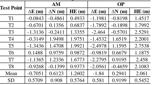
Table 2 shows the determined AM parameters with their standard deviation values (SD) and OP (Mugnier, 2000), respectively. The OP standard deviation values are not readily available in literature. The AM parameters and the OP (Table 2) were then applied to the test points as stated in Section 3.3 (Step 3) respectively. Table 3 presents the transformed test projected coordinates results for the AM and OP used in the GTM application.
Table 2: Transformation parameters
Parameter Official Parameters (OP) Arithmetic Mean (AM) Parameters
∆X 199 m 196.657 m ± 0.092 m
∆Y -32 m -33.072 m ± 0.623 m
∆Z -322 m -322.595 m ± 0.974 m
Table 3: Deviation of transformed projected coordinates from measured projected coordinates using GTM
∆E (m) ∆N (m) HE (m) ∆E (m) ∆N (m) HE (m) T1 -0.0843 -0.4861 0.4933 -1.1981 -0.8198 1.4517 T2 -0.6701 0.1356 0.6837 -1.7892 -0.1898 1.7992 T3 -1.3136 -0.2411 1.3355 -2.464 -0.5701 2.5291 T4 -0.3149 1.9498 1.9751 -1.4532 1.6519 2.2001 T5 -1.3436 1.4708 1.9921 -2.4978 1.1595 2.7538 T6 0.1488 0.9759 0.9872 -0.9819 0.6679 1.1875 T7 -1.1365 1.2336 1.6773 -2.2795 0.9195 2.458 T8 -0.9268 -0.1399 0.9373 -2.0561 -0.4659 2.1083 Mean -0.7051 0.6123 1.2602 -1.84 0.2941 2.061
SD 0.5709 0.908 0.5764 0.581 0.9199 0.5452
Test Point AM OP
It is evident from Table 3 that the AM produced a better results compared to the OP. The shortcoming in the OP results could be attributed to the reason that, its parameters were determined using only 3 collocated points in the year 1996 (Mugnier, 2000) when the new Ghana geodetic reference network was yet to be established. Therefore, applying more coordinate points within the newly established geodetic network in Ghana enabled the AM to give a better representation of the datasets characteristics and thus improved the GTM performance. A cursory observation of Figure 3 shows visible aspects of this assertion based on the horizontal position errors where there is a noticeable evidence of improvement when AM parameters were utilized in the GTM compared to OP.
5.2 Artificial Neural Network-Error Compensation Model (ANN-ECM)
It is a common practice to apply one test dataset for both validation and testing purposes, mostly with small datasets (Zhang, 2003; Ismail et al., 2012). Therefore, in the ANN-ECMs development, the 19 common points that form the newly established Ghana geodetic reference network was divided into two parts: 11 points form the training data and 8 comprise the test data (Table 1). It is important to note that the 11 training data and 8 testing data correspond to the same dataset used in the AM and OP application for the GTM. Because the AM results were better than the OP, the AM results produced by the GTM were used in the ANN-ECMs development. The ANN-ECMs procedure has been explained in Sect. 3.3.
Here, the ANN models (BPNN, RBFNN and GRNN) that was able to compensate more of the GTM generated errors based on the mean square error (MSE) criterion from the testing set was selected as the better ANN-ECM. That is, the closer the MSE value from the optimum BPNN, RBFNN and GRNN models in the testing data is to the target MSE value from the GTM model, the better the ANN models ability to compensate for the errors produced by the GTM thereby improving transformation performance. Therefore, after several trials, the optimal structure of BPNN-ECM used here consists of 3 inputs, 1 hidden layer of 2 neurons using the hyperbolic tangent as activation function and 3 outputs using linear activation function. While the RBFNN-ECM comprises of 3 inputs, one hidden layer of 11 neurons using Gaussian function as the nonlinear activation and 3 outputs using linear activation function. The GRNN-ECM structure was 3 inputs, smoothness parameter (σ) = 0.5 and 3 outputs respectively. In training the GRNN-ECM, the radial basis and linear activation function was used in the hidden and output layer.
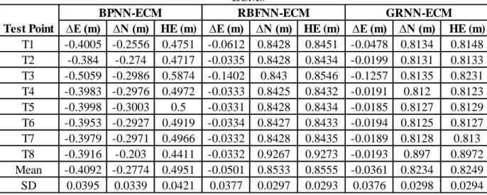
Table 4 presents the test projected coordinates differences (∆E, ∆N) obtained between the known projected coordinates with those obtained from the three ANN-ECMs. The HE, mean error and SD values of each test projected coordinates are also presented.
Table 4: Deviation of transformed test coordinates from measured coordinates using ANN-ECMs
∆E (m) ∆N (m) HE (m) ∆E (m) ∆N (m) HE (m) ∆E (m) ∆N (m) HE (m)
T1 -0.4005 -0.2556 0.4751 -0.0612 0.8428 0.8451 -0.0478 0.8134 0.8148 T2 -0.384 -0.274 0.4717 -0.0335 0.8428 0.8434 -0.0199 0.8131 0.8133 T3 -0.5059 -0.2986 0.5874 -0.1402 0.843 0.8546 -0.1257 0.8135 0.8231 T4 -0.3983 -0.2976 0.4972 -0.0333 0.8425 0.8432 -0.0191 0.812 0.8123 T5 -0.3998 -0.3003 0.5 -0.0331 0.8428 0.8434 -0.0185 0.8127 0.8129 T6 -0.3953 -0.2927 0.4919 -0.0334 0.8427 0.8433 -0.0194 0.8125 0.8127 T7 -0.3979 -0.2971 0.4966 -0.0332 0.8428 0.8435 -0.0189 0.8128 0.813 T8 -0.3916 -0.203 0.4411 -0.0332 0.9267 0.9273 -0.0193 0.897 0.8972 Mean -0.4092 -0.2774 0.4951 -0.0501 0.8533 0.8555 -0.0361 0.8234 0.8249 SD 0.0395 0.0339 0.0421 0.0377 0.0297 0.0293 0.0376 0.0298 0.0294
RBFNN-ECM GRNN-ECM
Test Point
BPNN-ECM
measured projected coordinates by way of errors. A critical look at Table 4 shows that the differences in all test points are below 1 m for all the three ANN-ECMs.
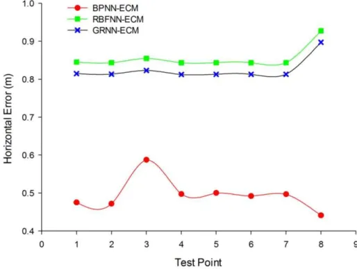
The HE values (Table 4) obtained signify the extent that the horizontal transformed coordinates produced by the BPNN-ECM, RBFNN-ECM and GRNN-ECM deviate from the measured horizontal coordinates. It also shows the positional accuracy of the transformed data in horizontal terms to the measured data. In comparison, the BPNN-ECM yielded a better horizontal positional accuracy than the RBFNN-ECM and GRNN-ECM as illustrated in Figure 4.
Figure 4: Horizontal position error for ANN-ECMs
This improvement in the horizontal displacements achieved by the BPNN-ECM means that, the model could compensate and absorb more of the errors in the GTM transformed coordinates better than the other methods. Also, the inference to be made here is that, the influence of the local geodetic network distortions in the GTM transformed coordinates has been more minimized by the BPNN-ECM thereby improving the GTM transformed coordinate results.
5.4 Comparison of ANN-ECM and GTM
Table 5 provides a summary of performance comparison among the ANN-ECMs, OP and AM used in the coordinate transformation. The evaluation of the results presented in Table 5 shows that the ANN-ECMs were superior to the AM and OP. Besides, the MSE values (Table 5) obtained by the ANN-ECMs compared to the AM and OP provide an independent measure of the ANN-ECMs performance. By virtue of the MSE values (Table 5), it can be stated that the transformed projected test coordinates rendered by the ANN-ECMs are in better agreement with the measured test data than the AM and OP.
Comparing the ANN-ECMs (Table 5), it was known that the RBFNN-ECM and GRNN-ECM had a better MSE value in the Eastings compared to BPNN-ECM. This might possibly be related to the inability of the BPNN-ECM to compensate more of the GTM transformed Easting coordinate errors better than the RBFNN-ECM and GRNN-ECM. In the case of the Northing coordinates the BPNN-ECM was better.
Table 5: Model Performance Statistic
∆E(m) ∆N(m)
BPNN-ECM 0.1688 0.0779
RBFNN-ECM 0.0038 0.7289
GRNN-ECM 0.0025 0.6787
AM 0.7824 1.0964
OP 3.6808 0.8269
Model MSE
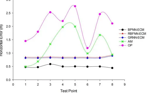
The horizontal error curves for the ANN-ECMs, AM and OP as shown in Figure 5 allows for a more intuitive interpretation. A careful study of Figure 5 revealed that the ANN-ECMs had a relatively small fluctuation with the high deviations mostly concentrated in the AM and OP. Therefore, the ANN-ECMs showed fairly stable variations compared to AM and OP respectively. Comparatively, the BPNN-ECM is much better than the other models considered in this study.
The total error obtained using the ANN-ECMs, AM and OP is summarized in Table 6 by the mean (Equation 12), SD (Equation 13), maximum and minimum coordinate differences respectively.
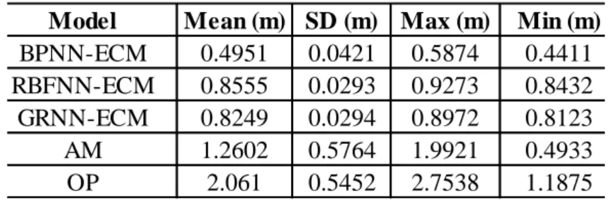
Table 6: Total error of the coordinate differences
Model Mean (m) SD (m) Max (m) Min (m)
BPNN-ECM 0.4951 0.0421 0.5874 0.4411
RBFNN-ECM 0.8555 0.0293 0.9273 0.8432
GRNN-ECM 0.8249 0.0294 0.8972 0.8123
AM 1.2602 0.5764 1.9921 0.4933
OP 2.061 0.5452 2.7538 1.1875
From Table 6, it can be seen that the BPNN-ECM, RBFNN-ECM GRNN-ECM, AM and OP predicts the horizontal position error (HE) with a minimum uncertainty in the order of approximately 0.44 m, 0.84 m, 0.81 m, 0.49 m and 1.19 m respectively. In addition, the overall maximum horizontal uncertainty of about 0.59 m, 0.93 m, 0.90 m, 1.99 m and 2.75 m was identified for BPNN-ECM, RBFNN-ECM, GRNN-ECM, AM and OP correspondingly.
Additionally, analysis of Table 6 shows that in our case of coordinate transformation from WGS84 datum to Accra datum using GTM, the ANN-ECMs are superior to AM and OP used in the GTM application. Comparatively, the BPNN-ECM could produce more reliable transformed projected coordinate values than the RBFNN-ECM, GRNN-ECM, AM and OP respectively. This is consistent with the BPNN-ECM attaining the least mean horizontal position error value of approximately 0.5 m (Table 6) compared to the values attained among the other models. Hence, indicating a significant improvement in the horizontal position accuracy of the transformed projected test coordinates given by the BPNN-ECM. This assertion is also in conformance with Figure 5 where the trend of the horizontal position errors has been displayed.
The inference made in line with the maximum and minimum values (Table 6) is that, the BPNN-ECM transformed projected test coordinates differed by not more than 0.6 m. In the case of the RBFNN-ECM and GRNN-ECM, approximately 0.9 m was realized. The AM and OP on the other hand, had approximately 2.0 m and 2.8 m respectively. These minimum and maximum values (Table 6) give a better indication about the accuracy range in the models applied in terms of their practicality. On the strength of the maximum and minimum values, the BPNN-ECM can thus be applied within the Ghana geodetic reference network for improving the GTM performance. Likewise, the results in Table 6 showed that the SD values obtained indicate the precision and accuracy of the BPNN-ECM transformed projected test coordinate values.
6. Concluding remarks
Coordinate transformation is necessary in the surveying and mapping industry particularly in developing countries like Ghana where the non-geocentric datum which is still utilized is highly heterogeneous. It also creates the opportunity to harmonize coordinates from different reference systems onto a common datum. Firstly, in this study, official parameters (OP) determined by the then DMA now NGA and the estimated arithmetic mean parameters (AM) were applied in the geocentric translation model to transform coordinates from WGS84 datum to Accra datum.
Conversely, unsatisfactory coordinate transformation results were achieved by AM and OP in the geocentric translation model application. To improve performance of the geocentric translation model, this study proposed a novel technique known as the Artificial Neural Network-Error Compensation Model (ANN-ECM) to transform coordinates from WGS84 datum to Accra datum. The ANN-ECM comprise of the BPNN-ECM, RBFNN-ECM and GRNN-ECM. The results obtained showed that the proposed ANN-ECMs are feasible for coordinate transformation within Ghana’s geodetic reference network. It was also observed that the transformation accuracy of the proposed ANN-ECMs were significantly better than when the geocentric translation model was applied separately. This implies that the proposed ANN-ECMs can better compensate for the errors of the geocentric translation model. In comparison, the BPNN-ECM, RBFNN-ECM and GRNN-ECM produced a maximum horizontal position error of approximately 0.59 m, 0.93 m and 0.9 m respectively. The attained values of the BPNN-ECM and GRNN-ECM are in direct compliance with the Ghana Survey and Mapping Division of Lands Commission horizontal position shift tolerance of ± 0.9144 m for cadastral surveying and plan production in Ghana. Nonetheless, the RBFNN-ECM results could still be used for mapping related activities where accuracy is not in high demand.
In view of this, the present authors recommend that, as the new geodetic reference network is being expanded to cover the Northern sectors and the whole country (Ghana) at large with more data availability, the Ghana Survey and Mapping Division of Lands commission should consider the adoption of the proposed approach as a practical alternative technique to improve geocentric translation model performance within the Ghana geodetic reference network. The advantage of this proposed approach lies in its ability to utilize the function approximation capabilities of both the geocentric translation model and ANN technology to produce promising coordinate transformation results. Furthermore, the obtained results have shown the computational superiority of combining knowledge based systems and data driven method.
To conclude, it can reasonably be stated that the concept of the proposed approach will serve as a preliminary study for compensating errors generated by the geocentric translation model within the Ghana geodetic reference network.
Acknowledgement
References
Abd-Elmotaal, H., and Ei-Tokhey, M. “The role of the geoid in the coordinate transformation.” Survey Review 34 (1997):31-40.
Acar, M., Ozludemir, M.T., Akyilmaz, O., and Ayan, T. “Total least squares in geodetic coordinate transformation”. American Geophysical Union, San Francisco, CA, USA (2006a).
Acar, M., Ozludemir, M.T., Akyilmaz, O., Celik, R.N., and Ayan, T. “Deformation analysis with total least squares.”Natural Hazards and Earth System Sciences 6 (2006b):663-669.
Akyilmaz, O. “Total least squares solution of coordinate transformation.” Survey Review 39 (2007):68-80.
Andrei, O.C. “3D affine coordinate transformations.” Masters of Science Thesis in Geodesy No. 3091 TRITA-GIT EX 06-004, School of Architecture and the Built Environment, Royal Institute of Technology (KTH), 100 44 Stockholm, Sweden (2006).
Ayer, J., and Fosu, C. “Map coordinates referencing and the use of GPS datasets in Ghana.” Journal of Science and Technology 28 (2008):116-127.
Ayer, J., and Tiennah, T. “Datum transformation by the iterative solution of the Abridging inverse Molodensky formulae.”The Ghana Surveyor 1 (2008):59-66.
Ayer, J. “Transformation models and procedures for framework integration of Ghana geodetic network.”The Ghana Surveyor 1 (2008):52-58.
Başçiftçi, F., Inval, C., and Başçiftçi, F. “Programming of geodetic transformation methods.” Science and Research Essay 5 (2006):1181-1188.
Dawod, G.M., Mirza, M.N., and Al-Ghamdi, K.A. “Simple Precise Coordinates Transformations for Geomatics Applications in Makkah Metropolitan Area, Saudi Arabia.” Bridging the Gap between Cultures, FIG Working Week, Marrakech, Morocco, 2010.
Deakin, R.E. “3D coordinate transformations.”Surv. Land Inf. Sys. 58 (1998):223-234.
Deakin, R.E. “A Note on the Bursa-Wolf and Molodensky-BadekasTransformations.” School of Mathematical and Geospatial Sciences, RMIT University, 2006:1-21.
Dzidefo, A. “Determination of transformation parameters between the World Geodetic System 1984 and the Ghana geodetic network.” Masters Thesis, Department of Civil and Geomatic Engineering, KNUST, Kumasi, Ghana, 2011.
Featherstone, W.E. “A Comparison of Existing Co-ordinate Transformation Models and Parameters in Australia.”Cartography 26 (1997):13-26.
Felus, Y.A., and Schaffrin, B. “Performing Similarity Transformations using the Error -in-Variable Model.” In ASPRS Annual Conference, Geospatial Goes Global: From Your Neighbourhood to the Whole Planet, Baltimore, Maryland, (2005):1-8.
Fernandez-Redondo, M., Torres-Sospedra, J., and Hernández-Espinosa, C. “Gradient Descent and Radial Basis Functions.”Intelligent Computing 4113 (2006):391-396.
Fraser, C.S., and Yamakawa, T. “Insights into the Affine Model for High-Resolution Satellite Sensor Orientation.” ISPRS Journal of Photogrammetry and Remote Sensing 58 (2004):275-288.
Gerdan, P.G., and Deakin, E.R. “Transforming Cartesian coordinates (X, Y, Z) to Geographical coordinates (,, h).”The Australian Surveyor 44 (1) (1999):55-63.
Grafarend, E.W., and Awange, J.L. “Nonlinear analysis of the three-dimensional datum transformation [conformal group C7 (3)].” Journal of Geodesy 77 (2003):66-76.
Gullu, M. “Coordinate Transformation by Radial Basis Function Neural Network.” Scientific Research and Essays 5 (2010): 3141-3146.
Gullu, M., Yilmaz, M., Yilmaz, I., and Turgut, B. “Datum Transformation by Artificial Neural Networks for Geographic Information Systems Applications.” International Symposium on Environmental Protection and Planning: Geographic Information Systems (GIS) and Remote Sensing (RS) Applications (ISEPP), Izmir-Turkey, (2011):13-19.
Haasdyk, J., and Janssen, V. “The many paths to a common ground: A comparison of transformations between GDA94 and ITRF.” International Global Navigation Satellite Systems Society Symposium, University of New South Wales, Australia, 2011.
Hartman, E.J., Keeler, J.D., and Kowalski, J.M. “Layered neural networks with Gaussian hidden units as universal approximations.”Neural Computation 2(1990):210-215.
Hornik, K., Stinchcombe, M., and White, H. “Multilayer feed forward networks are universal approximators.” Neural Networks 2(1989):359-366.
Ismail, S., Shabri, A., and Samsudin, R. “A hybrid model of self organizing maps and least square support vector machine for river flow forecasting.”Hydrology and Earth System Sciences 16(2012):4417-4433.
Janicka, J. “Transformation of Coordinates with Robust M-estimation and Modified Hausbrandt Correction.” 8th International Conference on Environmental Engineering, Vilnius, Lithuania,
2011:1330-1333.
Jitka, P. “Application of Dual Quaternions Algorithm for Geodetic Datum Transformation.” Journal of Applied Mathematics 4 (2011):225-236.
Karunaratne, F.L. “Finding out transformation parameters and evaluation of new coordinate system in Sri Lanka.”Masters Thesis, ITC, Enschede, Neatherlands, 2007.
Kheloufi, N. “Coordinates Transformation by Zoning Method for Parameters Computing between WGS84 and North Sahara.” Shaping the Change XIII FIG Congress, Munich, Germany, 2006:1-15.
Konaté, A.A., Pan, H., Khan, N., and Ziggah, Y.Y. “Prediction of Porosity in crystalline rocks using artificial neural networks: An example from the Chinese Continental Scientific Drilling Main Hole.”Stud. Geophys. et Geod. 59(2015):113-136.
Kotzev, V. “Consultancy service for the selection of a new projection system for Ghana.” Draft Final Reports, World Bank Second Land Administration Project (LAP-2), Ghana, 2013.
Lehman, R. “Transformation model selection by multiple hypotheses testing.” Journal of Geodesy 88(2014):1117-1130.
Leick, A. GPS Satellite Surveying. John Wiley and Sons, Inc., Hoboken, New Jersey, United States of America, 2004.
Lippus, J. “Transformation of coordinates using piecewise conformal mapping.” Journal of Geodesy 78(2004):40–46.
Mahboub, V. “On weighted total least-squares for geodetic transformations.” Journal of Geodesy 86(2012):359-367.
Mihalache, R.M. “Coordinate transformation for integrating map information in the new geocentric European system using artificial neural networks.” GeoCAD (2012):1-9.
Molnár, G., and Timár, G. “Determination of the parameters of the abridging Molodensky formulae providing the best horizontal fit.” EGU General Assembly, Vienna, Austria, Geophy. Res. Abstracts 7 (2005):1018.
Mugnier, J.C. “OGP-coordinate conversions and transformations including formulae, COLUMN, Grids and Datums. The Republic of Ghana.” Photogram. Eng. Remote Sensing (2000):695-697.
Newsome, G.G., and Harvey, B.R. “GPS coordinate transformation parameters for Jamaica.” Survey Review 37(2003):218-234.
Nocedal, J., and Wright, S.J. Numerical optimization 2nd edn. Springer Science and Business
media, LLC, New York, USA, 2006.
Paláncz, B., Zaletnyik, P., Awange, J.L., and Heck, B. “Extension of the ABC-Procrustes algorithm for 3D affine coordinate transformation.”Earth Planets and Space 62 (2010):857-862.
Park, J., and Sandberg, I.W. “Universal approximation using radial basis function networks.” Neural Computation 3(1991):246-257.
Poku-Gyamfi, Y., and Hein, W.G. “Framework for the establishment of a nationwide network of Global Navigation Satellite System (GNSS) – A cost effective tool for land development in Ghana.” 5th FIG Conference on Promoting Land Administration and Good Governance, Workshop – AFREF I, Accra, Ghana, 2006:1 -13.
Rapp, R.H. Geometric Geodesy-Part II. Lecture Notes, Department of Geodetic Science and Surveying, Ohio State University, USA, 1993:68-72.
Rey-Jer, Y., and Hwa-Wei, H. “Coordinate Transformation between Two Geodetic Datums of Taiwan by Least-Squares Collocation.” Journal of Surveying Engineering 132 (2006):64-70.
Schofield, W., Engineering Surveying: Theory and Examination Problems for Students. Butterworth-Heinemann, 5th ed., Linacre House, Jordan Hill, Oxford OX2 8DP, UK, 2001.
Shen, Y.Z., Chen, Y., and Zheng, D.H. “A quaternion-based geodetic datum transformation.” Journal of Geodesy 80(2006):233–239.
Soler, T. “A compendium of transformation formulas useful in GPS work.”Journal of Geodesy 72(1998):482-490.
Soler, T., and Marshall, J. “A note on frame transformations with applications to geodetic datums.”GPS Solutions 7(2003):23-32.
Soler, T., and Snay, R. “Transforming positions and velocities between International Terrestrial Reference Frame of 2000 and North America Datum of 1983.” Journal of Surveying Engineering 130 (2003):49-55.
Stanaway, R. “A dynamic datum for PNG-improving PNG94.” 42nd Association of Surveyors
PNG Congress, Port Moresby, The Surveyor in the dynamic technological world 2008:1-10.
Thomson, D.B. “A study of the Combination of Terrestrial and Satellite Geodetic Networks.” Ph.D. Dissertation, Department of Surveying Engineering, University of New Brunswick, Canada, 1976.
Tierra, A., Dalazoana R., and De Freitas, S. “Using an Artificial Neural Network to Improve the Transformation of Coordinates between Classical Geodetic Reference Frames.” Computers and Geosciences 34(2008):181-189.
Tierra, A.R., De Freitas S.R.C., and Guevara, P.M. “Using an Artificial Neural Network to Transformation of Coordinates from PSAD56 to SIRGAS95.” Geodetic Reference Frames, International Association of Geodesy Symposia, 134(2009):173-178.
Tierra, A., and Romero, R. “Planes Coordinates Transformation between PSAD56 to SIRGAS using a Multilayer Artificial Neural Network.” Geodesy and Cartography 63 (2014):199-209.
Turgut, B. “A Back-Propagation Artificial Neural Network Approach for Three-Dimensional Coordinate Transformation.” Science and Research Essay 5 (2010):3330-3335.
Vanicek, P., and Steeves, R.R. “Transformation of coordinates between two horizontal geodetic datums.” Journal of Geodesy 70(1996):740-745.
Yakubu, I., and Kumi-Boateng, B. “Ramification of datum and ellipsoidal parameters on post processed differential global positioning system (DGPS) data – A case study.” Ghana Mining Journal 15(2015):1-9.
Yilmaz, I., and Gullu, M. “Georeferencing of Historical Maps using back propagation artificial neural network.” Experimental Techniques 36(2012):15-19.
Zaletnyik, P.Ms. “Coordinate Transformation with Neural Networks and with Polynomials in Hungary.” International Symposium on Modern Technologies, Education and Professional Practice in Geodesy and Related Fields, Sofia, Bulgaria, 2004:471-479.
Zeng, H. “Analytical algorithm of weighted 3D datum transformation using the constraint of orthonormal matrix.”Earth Planets and Space 67, 2015.
Zeng, H. “A 3D coordinate transformation algorithm.” 2nd Conference on Environmental Science
and Information Application Technology (ESIAT), Wuhan, P.R. China, (2010):195-198. doi:10.1109/ESIAT.2010.5568580
Zeng, H., and Yi, Q. “A New Analytical Solution of Nonlinear Geodetic Datum Transformation.” Geoinformatics, 18th International Conference on, 2010:1-5. doi: 10.1109/GEOINFORMATICS.2010.5568048
Zeng, H., and Yi, Q. “Quaternion-based iterative solution of three-dimensional coordinate transformation problem.”Journal of Computers 6 (2011):1361-1368.
Zhang, G.P. “Time series forecasting using a hybrid ARIMA and neural network model.” Neurocomputing 50 (2003):159-175.
Ziggah, Y.Y., Youjian, H., Odutola, C.A., and Fan, D.L. “Determination of GPS Coordinate Transformation Parameters of Geodetic data between Reference Datums - A Case Study of Ghana Geodetic Reference Network.” International Journal of Engineering Sciences and Research Technology 2 (2013): 2277-9655.
Recebido em 10 de março de 2016.