World Transport Policy & Practice
ISSN 1352-7614
Volume 6, Number 2, 2000
Mission StatementWorld Transport Policy & Practice is a quarterly journal which provides a high quality medium for original
and creative work in world transport.
WTPP has a philosophy based on the equal importance of academic rigour and a strong commitment to ideas, policies and practical initiatives that will bring about a reduction in global dependency on cars, lorries and aircraft.
WTPP has a commitment to sustainable transport which embraces the urgent need to cut global emissions of carbon dioxide, to reduce the amount of new infrastructure of all kinds and to highlight the importance of future generations, the poor, those who live in degraded environments and those deprived of human rights by planning systems that put a higher importance on economic objectives than on the environment and social justice.
WTPP embraces a different approach to science and through science to publishing. This view is based on an honest evaluation of the track record of transport planning, engineering and economics. All too often, these interrelated disciplines have embraced quantitative, elitist or mechanistic views of society, space and infrastructure and have eliminated people from the analysis.
To help it to reach a wide readership, encompassing advocates and activists as well as academics and advisers, WTPP is available free of charge as PDF files on the internet at http://www.ecoplan.org/wtpp/
World Transport Policy & Practice
ISSN 1352-7614
Volume 6, Number 2, 2000
Contents
3 Abstracts & Keywords 4 Editorial
5 Sustainably Distributed? An environmental critique of the UK Government’s 1999 White Paper on Distribution
Francis M Vanek
13 Mobility & Accessibility: the yin & yang of planning
William Ross
20 The Vasco da Gama Bridge on the Tagus Estuary: A paradigm of bad decision making, but good post-evaluation
João Joanaz de Melo
32 Pedestrian priority planning principles
John Seaton
40 Let’s Bike – The 10 Point Pedalling Action Programme to support cycling
Ulrike Huwer
45 Notes for contributors
——————————————————————————————————————————————————
© 2000 Eco-Logica Ltd ISSN 1352-7614
Editor
John Whitelegg
Professor of Environmental Studies, Liverpool John Moores University, Clarence Street, LIVERPOOL, L3 5UG, U.K.
Editorial board
Eric Britton
Managing Director, EcoPlan International, The Centre for Technology & Systems Studies, 8/10 rue Joseph Bara, F-75006 Paris, FRANCE.
John Howe
Professor of Transportation Engineering, International Institute for Infrastructural, Hydraulic & Environmental Engineering, P.O.Box 3015, 2601 DA Delft, THE NETHERLANDS.
Mikel Murga
Leber Planificacion e Ingenieria, S.A., Apartado 79, 48930-Las Arenas, Bizkaia, SPAIN. Paul Tranter
School of Geography and Oceanography, University College, University of New South Wales, Australian Defence Force Academy, Canberra ACT 2600, AUSTRALIA
Publisher
Eco-Logica Ltd., 53, Derwent Road, LANCASTER, LA1 3ES, U.K. Telephone +44 1524 63175 Fax +44 1524 848340
Editorial 4 ——————————————————————————————————————————————————
It is now quite clear that the UK Government has completely lost the plot in its attempts to deal with traffic and transport problems. It has rejected traffic reduction targets after initially agreeing to them, it has rejected lower speed limits on rural roads and through villages and it is now devoting its efforts to making the purchase price of new cars lower. As if this wasn’t enough to signal a major political
withdrawal from the electorally difficult territory of reducing our dependence on the car the Government has now refused to become involved in the European Car-Free Day planned for 22nd September this year. It
takes the view that this is essentially a local matter and must be decided by individual towns and cities.
This re-positioning of a Government that was elected in 1997 with one of the biggest majorities in parliament ever seen in the UK is full of lessons for the world of transport policy. The UK has no shortage of good ideas about how to solve transport problems. The history of exceptionally innovative traffic analysis and understanding is peppered with the work of Smeed, Buchanan, Mogridge, Roberts, Adams, Hillman and others; all of whom have shown that it is not possible to have our cake and eat it in terms of ever-rising rates of car ownership and use and ensuring that towns and cities are livable and desirable. This wealth of intelligence has had to come to terms with the political realities which in the main lean in the direction of more cars, more use of cars and a staggering underestimation of the damaging consequences of this auto-centred approach.
The main lesson to be drawn from this history is a hard one. Progress does not come from clear, articulate analysis. The Government knows about the health impacts of traffic, the rapidly escalating problems of climate change and the impossibility of paying for and maintaining transport infrastructure up to the task of 100% car ownership, car parking requirements and use of cars for every trip greater than 50 metres. It knows that new roads do not solve traffic congestion problems and do not bring about the economic miracle that is supposed to follow a new road. It knows that poor people suffer more from appalling noise, air quality and traffic danger environments than do rich people. Contemporary highly paid professionals are
just as adept at escaping from the highly unpleasant world of traffic (which they create) as were their Victorian predecessors in escaping the dark, satanic mills (which they created). We have an overload of information and a deficit of backbone to do anything about it.
There is a glimmer of light in what is going on elsewhere in Europe. The enthusiastic application of car-free days in France and Italy is certainly not a fully packaged transport solution but it is showing millions of people the kind of world that normally doesn’t even begin to penetrate the consciousness of those locked into car dependency. This is the sadness of the UK’s thoughtless denial of 22nd September. Car
dependency is a psychological problem and the start of any solution has to be the growing awareness that things could be better if there were fewer cars around or if ordinary, everyday journeys could be made by an alternative to the car. The main positive lesson of the dreary history of traffic and transport policy in Britain in the last 50 years is that we have to find ways to show that there is a huge improvement in health, quality of life, sociability and
neighbourliness just around the corner and it is there to be liberated if only we can put the genie back in the bottle and get on with a life that celebrates the joy of human contact, the richness of public space and the pleasure of being freed from servicing the metal box that offers so much and yet delivers so little.
Writing in 1933 in Street Traffic Flow (p. 375) Henry Watson concluded his analysis with:
‘In the future the central areas of great cities will be closed to private vehicles of limited utility…’ Almost 70 years later we are still waiting. I wonder what Henry Watson would have made of our craven inability even to think of one car free day in a year.
John Whitelegg Editor World Transport Policy & Practice
Reference
Watson, H (1933) Street Traffic Flow Chapman & Hall, London
Abstract
The Vasco da Gama bridge over the Tagus Estuary was one of the most polemic projects ever built in Portugal and indeed in the European Union. Benefiting from significant funding from the Cohesion Fund, the project failed to uphold its main declared objectives (decongesting the old bridge and providing a north-south link around Lisbon), and its location was the worst of three alternatives regarding land
management, nature conservation, transportation system and cost. It was nevertheless forwarded by the will of the very powerful Portuguese Ministry of Public Works (against opinions of almost everybody else), aided by the unwillingness of the European Commission to withdraw financing. However, the public outrage raised around the project both in Portugal and in Europe, not only for the sloppy decision but also for illegal impacts during construction, led to several stringent control and compensatory measures, unprecedented in Portugal and rare in Europe.
Keywords
Cohesion Fund, Environmental Impact Assessment, European Union, Lisbon, NGO, Tagus Estuary.
Introduction
The new Vasco da Gama bridge over the Tagus Estuary was commissioned in 1998. It is one of the longest in Europe, but unfortunately it became well known for much less auspicious motives. From the original decision to this day (and probably for years to come), the project has generated unprecedented controversy in Portugal and Europe, for a number of reasons:
• It does not fulfil any of the goals it was supposed to meet, and indeed impedes the resolution of
problems it was supposed to solve;
• The choice of location for the bridge was, by all accounts, the worst possible option;
• It creates very significant negative social, ecological and economic impacts;
• It was made possible only by heavy EU financing, despite multiple violations of European
regulations. In short, this project has become a textbook example of poor decision making, sloppy economics, poor use of public money and excessive environmental impact fostered by public works. On the other hand, the huge problems it conjured up led to the creation of an observation committee, Comissão de Acompanhamento da Obra (CAO), which is unique in Portugal and has in turn become a textbook example of co-operative efforts to mitigate impacts of a major project (not always successful, but nevertheless valiant).
This paper briefly describes the decision process that led to the new bridge and explores the
environmental, economic and financial consequences; then it proceeds to discuss the role of the EU in the process, the current problems in land use planning and the role of CAO. The reader will notice that decisions of Portuguese and European authorities are
apparently senseless and often contradict available technical background information. If in doubt, the reader is strongly advised to check on source documents (now in the public record), because the whole affair is incredible to the untutored observer.
The decision process
In 1991 the Portuguese Government created the Office for the Crossing of the Tagus at Lisbon, Gabinete para a Travessia do Tejo em Lisboa
(GATTEL), an inter-ministerial agency chaired by the Ministry of Public Works, Ministério das Obras Públicas Transportes e Communicações (MOPTC), with representatives of the Ministries of Planning
(Ministério do Planeamento e Administração do Território), Environment (Ministério do Ambiente e Recursos Naturais) and Finance (Ministério das Finanças). GATTEL was charged with the development of a new road crossing of the Tagus Estuary, with two clear cut goals: solving the ever-increasing traffic jam on the old ‘25 Abril’ bridge at Almada; and supporting the north-south traffic
The Vasco da Gama Bridge on the Tagus Estuary: A paradigm
of bad decision making, but good post-evaluation
João Joanaz de Melo
Address for correspondence João Joanaz de Melo
Professor Auxiliar Convidado, Departamento de Ciências e Engenharia do Ambiente, Faculdade de Ciências e Tecnologia, Universidade Nova de Lisboa, 2825-114 CAPARICA, PORTUGAL.
de Melo: The Vasco da Gama Bridge on the Tagus Estuary: A paradigm of bad decision making, but good post-evaluation World Transport Policy & Practice, Volume 6, Number 2, (2000) 20–31 21
——————————————————————————————————————————————————
around Lisbon.
One should note that the Tagus Estuary at Lisbon is very broad (up to 20 km in places) and any new
crossing is an expensive, technically challenging enterprise. GATTEL was directed to consider road transport only, without any integrated land use management or transportation perspective. Unco-ordinated to the work of GATTEL, studies went on to install a heavy railway on the old bridge and to create the Regional Land Use Plan for the Metropolitan Area of Lisbon, Plano Regional de Ordenamento do Território da Área Metropolitana de Lisboa (PROTAML).
By September 1991, GATTEL issued a series of studies (GATTEL, 1991) comparing three corridors for a new road bridge: eastern (Sacavém–Montijo), central (Chelas–Barreiro) and western (Algés–Trafaria). At the time, little of this information was released and no Environmental Impact Assessment or public auditing was conducted. Public debate was promoted only by non-Governmental organisations, both professional and environmental. Opinions fell to two
global alternatives, linked to opposite development strategies for the Metropolitan Area of Lisbon: • The ‘MOPTC option’: Sacavém–Montijo road
bridge, complemented with heavy railway on the old 25 Abril bridge and eventually a new
Chelas–Barreiro railway bridge. This option was
based on a strategy of opening new urban
development fronts, top priority to roadways and individual transport. It was actively and loudly supported by the Minister of Public Works and the municipalities of Montijo and Alcochete;
• The ‘Rest of the World option’: Chelas–Barreiro
rail and road bridge, complemented with a light railway on the old bridge. This option was based
on a strategy of urban regeneration, an integrated approach to land use and transportation, and priority for public transport. It was supported by the Ministries of Planning, Environment, Industry, Employment, Defence and Justice (among others), by the planning office and GATTEL’s consultants, by the PROTAML team, by the municipalities of Almada, Barreiro, Seixal and Moita, by the mayor
and the municipal planning office at Lisbon, by environmental NGOs and by the majority of experts on transport, land management and
environment.
The Sacavém–Montijo route crosses a Special Protected Area under the European Birds Directive, which is considered one of the ten most important wetlands in Europe. It does not solve the two major problems (congestion on the old bridge and north-south link), because it is away from populated areas. It causes major impacts on wildlife (bird and fish habitats), generates road traffic and agricultural land is urbanised. Official reports (GATTEL, 1991; MPAT, 1992) show that the ‘Rest of the World option’ would fare much better in solving
transportation and
de Melo: The Vasco da Gama Bridge on the Tagus Estuary: A paradigm of bad decision making, but good post-evaluation World Transport Policy & Practice, Volume 6, Number 2, (2000) 20–31 22
——————————————————————————————————————————————————
development problems, would be less expensive and would induce far less impacts. The reason is
immediately apparent just by looking at a map of the region (see Figure 1): the area around Barreiro is much more urbanised and populated, by a factor of ten, than the vicinity of Montijo.
The question that now springs to the mind of any and every observer is: Why on earth was the
MOPTC’s Sacavém–Montijo road bridge option chosen?
Unfortunately, the answer is unfathomable. One can just say that nearly all stakeholder positions were founded on objective, if misguided reasons. For
instance, the municipalities of Montijo and Alcochete favoured the Montijo location because, quite clearly, they were bound to gain (politically and financially) with that location for the new crossing. The one exception, the never satisfactorily explained position, was that of the Minister of Public Works.
This forceful, unfounded position of the Minister of Public Works prevailed over an unorganised
opposition, and the Sacavém–Montijo bridge was approved by Government in July 1992. The draft PROTAML that recommended the ‘Rest of the World option’, was ordered back to redrafting. Legislation was approved to establish the location and financing model of the bridge, based on a joint concession of the new and the old bridges – with much higher tolls than before.
A major hurdle appeared, predictably, in June 1994, when the tolls on the old bridge were raised by 50%; this was to be a first step of a programmed 250% toll increase, preparing for the takeover by Lusoponte (the chosen contractor). The ensuing public outrage became the biggest political crisis of the decade, and
shattered the ‘financial engineering’ of the project, based on toll revenues – of which over 80% would come from the old bridge. The Government had to make a number of concessions, both to the old 25 Abril bridge users and to Lusoponte; amongst them, no further toll raising. Henceforth, the project became heavily dependent on the Government budget.
By summer 1994, the Environmental Impact Statement (drafted for the Sacavém–Montijo option only) was issued and reviewed, receiving inordinately harsh criticism from the scientific community, the Government agencies and environmental NGOs. For example, the Ministry of the Environment Evaluation Committee noted that:
‘The Environmental Impact Statement does not justify the project. There is no evidence of the goals
stated in the EIS (diverting north-south and Spain-bound heavy traffic from the urban centre and solving the saturation of the existing 25 Abril bridge) being met by the project. In truth,
additional information commissioned by the Evaluation Committee imply that the 25 Abril bridge will continue to present high saturation rates. Furthermore, the volume of regional heavy traffic crossing the existing bridge is already very small.’ (MARN, 1994, p. 35).
Despite this criticism by the Ministry of the Environment, by the end of 1994 the project had been approved by the Portuguese Government and by the EU’s Cohesion Fund.
All these decisions and violations by Portuguese and European authorities, and others by Lusoponte, were strongly opposed by environmental NGOs, led by GEOTA (Grupo de Estudos de Ordenamento do
Território e Ambiente) and LPN (Liga para a Protecção da Natureza). They mounted a public campaign and filed some eight lawsuits for infringement of Directives 85/337/EEC
(Environmental Impact Assessment), 79/409/EEC (Birdlife), 92/43/EEC (Habitats) and other legislation; some of which are still pending in the courts. In addition, they placed a long list of complaints before the European Commission.
The last opportunity to stop the project was missed when the new Government, elected in October 1995, decided to keep the project going, despite openly considering it totally inadequate to fulfil its stated goals. The decision to carry on may have been pressed by the upcoming Expo ’98 (the World Exposition in Lisbon from May to September), and by the financial commitments already assumed by the Portuguese State.
Non-compliance with project goals
All official documents issued by the Portuguese Government are unanimous in defining two goals for the new crossing of the Tagus at Lisbon: alleviating traffic on the old 25 Abril bridge and providing a north-south link around Lisbon. These goals are clearly stated in the preamble of Decreto-Lei no. 14-A/91 de 9 de Janeiro, the Government Decree creating GATTEL; in the application to the Cohesion Fund (MPAT, 1994); and in the Environmental Impact Statement for the Montijo bridge (GATTEL/ Lusoponte/Coba, 1994, Tomo I, p. 3).
Amazingly, according to all available data, the Sacavém–Montijo bridge quite clearly does not satisfy any of its pretended goals.
de Melo: The Vasco da Gama Bridge on the Tagus Estuary: A paradigm of bad decision making, but good post-evaluation World Transport Policy & Practice, Volume 6, Number 2, (2000) 20–31 23
——————————————————————————————————————————————————
Let us briefly examine the official reports.
Regarding the north-south link:
‘The traffic crossing the AML (Metropolitan Area of Lisbon), so without origin or destination in the AML, represents only 0.2% of light vehicle traffic crossing the Tagus at Lisbon and 0.3% of heavy traffic … The analysis performed shows that none of the corridors under consideration (western, central and eastern) is interesting as far as the improvement of the north-south link of the country is concerned’ (GATTEL, 1991, report 4, p. 2.14). Thus the so-called north-south link does not explain, either the need for a new bridge, or the insertion of the bridge in the national network. As for the Spain-bound traffic, it is insignificant and not even quantified in official reports. On the contrary, the future Tagus crossing at Carregado (located about 30 km upstream from Lisbon), which has been planned for about fifteen years, will unquestionably become the main north-south crossing, and the best route between Setúbal and the West and North of the country, around Lisbon.
Regarding the traffic congestion of the existing bridge:
‘The eastern corridor does not contribute significantly to relieve the saturation of the existing bridge’ (GATTEL, 1991, report 6, p. 18). All traffic experts agree that the traffic overload of the old bridge can be solved only by railway crossings and a significant improvement of public transportation modes and nodes. However, the corollary of this evidence – priority for railway
crossings – was never accepted by the Government. But even if the priority for roadways was right, there is no justification for the choice of the Sacavém–Montijo route. According to GATTEL (1991, report 4, p. 3.106), a bridge on the eastern corridor (Montijo) would divert up to 19% of the traffic on the old bridge, on the central corridor (Barreiro) up to 46% and on the western corridor (Trafaria) up to 99%. The same trend was confirmed by the traffic studies supporting the application to the Cohesion fund (MPAT, 1994).
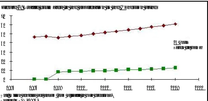
According to this official 1994 document, accepted by the European Commission, the new bridge would generate a surplus of seven million vehicles in 1998, above and beyond normal traffic growth rates (see Figure 2). That is, the new bridge generates its own traffic by promoting urban growth, but does not divert significantly the traffic from the old bridge, for the very simple reason that it is too far away from existing major urban areas. This prediction was confirmed in full with real data (see Table 1).
In the period between 1992 and 1995 the Minister of Public Works invoked several reasons (besides the decongestion of the old bridge and the north-south link) to justify his preference for the Montijo location. Those accessory reasons were however never assumed in formal Government papers, so they will not be discussed in detail here. Let us just say that his opinions were not shared by his Government
colleagues, and were essentially contradictory with the official data, as demonstrated by, e.g. Melo (1995), Shmidt (1995), Granado (1996), and many other analysts. 70 60 50 40 30 20 10 0 1994 1996 1998 2000 2002 2004 2006 2008 2010
Figure 2: Traffic estimates in the application to the Cohesion Fund
Unit: million vehicles per annum (sum of traffic in both directions) Source: MPAT, 1994.
◆ 25 Abril
de Melo: The Vasco da Gama Bridge on the Tagus Estuary: A paradigm of bad decision making, but good post-evaluation World Transport Policy & Practice, Volume 6, Number 2, (2000) 20–31 24
——————————————————————————————————————————————————
One may note that the percent distribution of traffic between the two bridges (CCRLVT, 2000b) is remarkably close to early predictions. However, the
total traffic is significantly higher than expected,
especially on the new Vasco da Gama bridge. This discrepancy can be explained by two factors: • The 1991 studies by GATTEL assumed that
Governmental policy would promote public transportation. This did not happen. The most important project to reduce traffic on the 25 Abril bridge, the Southern Bank Light Train, that should interface with the bridge train, is at least 6 years behind schedule. This ‘policy for cars but no transportation policy’ affects other public
transport projects on both sides of the estuary, including new interchanges and the modern Lisbon tramway system. Therefore, increasing road construction has provoked an inordinate traffic increase;
• A significant share (as yet not quantified) of the traffic currently crossing the Vasco da Gama bridge is probably north-south traffic. This traffic will disappear, however, when a new bridge is built upriver at Carregado, because it is a much more practical and cheaper north-south route. The Carregado bridge should be in place in a few years, according to current planning.
The environmental impacts
It was clear from the earliest studies that the Sacavém–Montijo route, besides not complying with pretended goals, had the worst environmental impact of the alternatives considered:
‘The eastern corridor presents the highest environmental hazards’ (GATTEL, 1991, report 4, p. 3.33);
‘it promotes the extension and dispersion of urban development, with highest facility building effort; it is grounded on the southern bank in an area where urban structure to support rapid development is very fragile; it presents relevant negative effects on the Tagus Estuary, terrestrial ecosystems and environmentally
sensitive areas’ (GATTEL, 1991, report 6, p. 18).
The Environmental Impact Assessment of the Sacavém–Montijo bridge, in 1994, confirmed the earlier prognosis:
‘The Evaluation Committee concludes that this project, by its features and dimension, will
cause changes with regional scope … amongst which the most significant impacts are: land management, economic and social issues, especially on the southern bank; the ecological equilibrium of the estuary and surrounding areas. The Evaluation Committee notes very significant negative impacts, some not subject to mitigation, and others that need more thorough study to allow for any meaningful mitigation.’ (MARN, 1994, p. 36).
Unfortunately, not only were these warnings overlooked and the project approved, but also many of the mitigation measures proposed in the
Environmental Impact Statement, or demanded by Portuguese and European authorities, failed to be enforced.
Major violations by either Lusoponte, the
Portuguese Government or the municipalities included: • An attempt to cut the Tagus Estuary Special
Protection Area (SPA) on the northern bank, to build a new highway right over the bank (this project was later redesigned to affect the SPA as little as possible);
• Construction works on Samouco saltpans (southern bank) during the bird nesting season;
• Dredging operations during incoming tide in sensitive areas;
• Dumping of dredged sediments outside designated areas. Particularly, dumping of contaminated sediments inside the estuary, with yet unknown consequences. Such materials were supposed to be dumped off the coast, but according to Lisbon harbour records, only 2% of the contaminated sediments were actually dumped outside the estuary, and even then there is evidence that they did not reach the designated destination (Granado, 1996);
• Failure to fence off construction grounds, resulting in bird life disturbance and, more seriously, the deaths of two children who drowned in an unprotected ditch;
• Approval of urban developments inside the SPA;
Table 1: Traffic crossing the Tagus at Lisbon, 1997 to 1999 25 Abril bridge Vasco da Gama bridge Total
1997 50.2 0.0 50.2
1998 49.3 10.2 59.5
1999 57.0 15.9 72.9
Unit: million vehicles per annum (sum of traffic in both directions)
Source: CCRLVT (2000) citing Lusoponte, corrected with data from Junta Autónoma de Estradas
de Melo: The Vasco da Gama Bridge on the Tagus Estuary: A paradigm of bad decision making, but good post-evaluation World Transport Policy & Practice, Volume 6, Number 2, (2000) 20–31 25
——————————————————————————————————————————————————
• Failure to approve meaningful land use
management instruments, namely the PROTAML. All these violations were known to Portuguese authorities, were denounced over time by the NGOs to the European Commission, and were presented in the media with hard evidence. To no avail. The action of the authorities was always too little, too late, if ever.
The economics
The alleged lower cost was at some point one of the arguments of the Minister of Public Works to justify the option for the Montijo bridge. However, this argument, like all the others, was contradicted by official reports. For instance, the Council for Public Works and Transport, that compared road-only corridors found the following:
‘Regarding the technical solutions and
corresponding costs: On the eastern and central corridors no special problems are foreseeable in the foundations, therefore cost per kilometre is judged to be similar in both corridors; on the eastern corridor there may be technical problems of some complexity, such as found in the construction of the 25 Abril bridge.’ (CSOPT, 1992, p. 24)
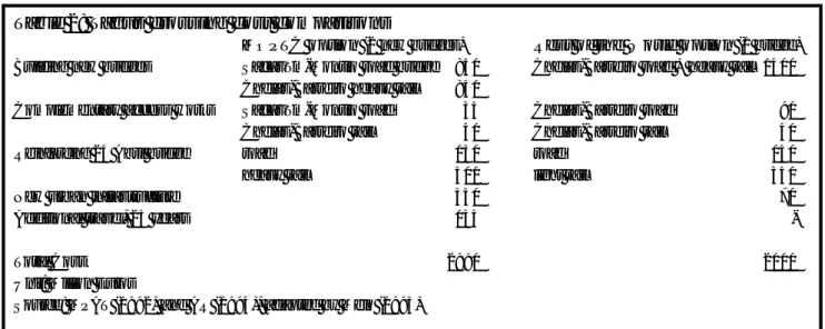
But what was really at stake was not the cost of a road bridge standing by itself, but the cost of the overall transport system and the level of service provided to users. Official reports show that a road and rail bridge at Chelas–Barreiro plus a light railway on the existing 25 Abril bridge would be much cheaper than a road bridge at Sacavém–Montijo plus a heavy railway on the 25 Abril bridge, in addition to the cost of urban facilities and added travel cost – see Table 2.
Although these figures are tentative, the
conclusion is beyond doubt. For a similar level of service (two roadways, two railways), and not accounting for further consequences regarding environment impact and regional development, the ‘MOPTC option’ is € 790 million (or greater than one-third) more expensive then the ‘Rest of the World option’.
The project finance is equally grim. The Contract between the Portuguese State and Lusoponte
established, as a matter of principle, that the revenues of the concession should come from tolls on both bridges, and, supposedly, the financial risks should fall to Lusoponte. The reality, however, is somewhat different. First, the public outcry in 1994 saw to it that the tolls would not increase as programmed, hence the State Budget is paying something around € 25 million per year to Lusoponte as compensation. What should have been an exception clause became the main revenue of Lusoponte. Second, the contract contains a number of clauses that, in practice, transfer most of the financial risk to the Portuguese State. Clause 101.1 is instructive:
Taking into account the distribution of risk stated in article 99, Lusoponte will have the right to the reposition of financial equilibrium, in the
following cases:
a) Unilateral modification of the conditions of activities integrated in the Concession, if, as a result of such modification, a significant reduction of revenue or added cost ensues; b) Unpredictable circumstances according to article 92, except if, as a result, ensues the resolution of the Contract according to number 92.3;
c) Exceptionally serious perturbations in the foreign exchange market which provokes
Table 2: Tagus crossing cost comparisons
MOPTC option (2 new bridges) Rest of the World option (1 bridge)
Building new bridges Sacavém-Montijo road bridge 850 Chelas-Barreiro road + heavy rail 1400 Chelas-Barreiro heavy rail 850
Complementary access works Sacavém-Montijo road 35 Chelas-Barreiro road 90 Chelas-Barreiro rail 40 Chelas-Barreiro rail 40
Reinforcing 25 Abril bridge road 150 road 150
heavy rail 500 light rail 350
New urban infrastructure 330 70
Additional travel, 25 years 135
-Total Cost 2890 2100
Unit: Million Euros
de Melo: The Vasco da Gama Bridge on the Tagus Estuary: A paradigm of bad decision making, but good post-evaluation World Transport Policy & Practice, Volume 6, Number 2, (2000) 20–31 26
——————————————————————————————————————————————————
substantial changes in the principles of the Base Case;
d) Legislative changes that have a significant direct impact on revenues or operation costs of the crossings;
e) Cases where the right to the reposition of financial equilibrium are specifically granted in the Contract …’ (Clause 101.1)
If we overlook the warranties for unpredictable situations, diminishing tolls and foreign exchange unbalance, there is still one fundamental issue: traffic. Clause 101.1 implies that, whenever foreseen toll revenues fail for any reason resulting from State policy, the State must compensate Lusoponte. Changes in the amount of traffic in relation to the Base Case, caused for instance by incentives to use public
transportation, may fall into such a category, because the Base Case has little flexibility regarding
passenger transfer to alternative modes, be it railway, boat or road. Thus, significant investments in public transportation may result in the State paying substantial amounts of compensation to Lusoponte. Depending on the difference between programmed and actual tolls, and the difference between forecast and actual traffic, the transfers from the State Budget to Lusoponte may increase to € 50 million per year, or more, within twenty years.
The on-going land use planning problem
It is a well-known phenomenon that a new road, especially a river crossing, generates traffic and urban growth; moreover in a suburban area. The bridge influence is more worrying because this is a still largely rural area, with little capacity to
accommodate rapid urban growth, insufficient urban facilities (from sewerage to public transportation), and on the doorstep of the Tagus Estuary SPA. This is why land use planning is a key issue here.
Uncontrolled urban growth is one of the most serious impacts of the new bridge, and one that was little and poorly studied in the 1994 Environmental Impact Statement (see, e.g., MARN, 1994, pp. 14-15). Although this has been recognised as a very serious failure, for nearly five years no effort was made by the authorities to gather information to evaluate the impact of the bridge on land use, despite repeated demands from the environmental NGOs, at CAO (1996/98a) and elsewhere (GEOTA/LPN/Quercus, 1998).
Only recently the so-called ‘observatory of land use on the south bank’ was furnished with adequate staff and funding to gather information on the issue.
The first report with some hard data was released in July, 1999 (CCRLVT, 1999).
The Environmental Impact Statement,
(GATTEL/Lusoponte/Coba, 1994) listed a vast number of issues and specific actions regarding land use management and urban control (see EIS, tomo II, volume 3, pp. 75-86). These actions and measures are synthetically described in table 9.2.1(7) of the same volume of the EIS. Unlike mitigation measures for construction works (that fall mostly to Lusoponte), land management and urban control measures fall to either the municipalities (local scale) or the Government (regional scale). Regional level is the most important, as recognised by the EIS and the Ministry of the Environment’s Evaluation Committee.
The major issue at municipal level was the approval and integration of the bridge in the municipal land management plans, Plano Director Municipal (PDM). However, a PDM, or a collection of PDM, do not fulfil any of the regional goals. A PDM is purely municipal and limited in scope. It is checked by the Government for legality, but it does not undergo any evaluation of merit regarding regional or national criteria other than law. It does not and cannot address issues like regional integration, total urban growth in the area, urban facilities, transportation,
demographic changes or ecological corridors between protected areas – all of which are essential for any meaningful land management and urban control.
Among the recommendations of the 1994 EIS, the following should be outlined:
1) Improving the mobility in the region, regarding especially the public transportation and the road-rail interfaces (p. 78);
2) Definition of urban green areas and semi-natural areas at the regional level, to avoid
compartmentalising the natural space, to
guarantee appropriate ecological equilibrium and access for the population to high-quality
recreational areas (p. 78);
3) Definition and integration of needs for urban facilities on a regional scale, including preferred sites and means of implementation (p. 8);
4) Definition, for the region and, co-ordinately, for each municipality, of maximum and desired levels of density and concentration of urban growth, according with the hierarchy of urban centres and actual growth needs (pp. 78-79);
5) Keeping, with a very high priority, the natural corridors between sensitive areas, namely the links Tagus–Coina–Arrábida, Corroios–Lagoa de
de Melo: The Vasco da Gama Bridge on the Tagus Estuary: A paradigm of bad decision making, but good post-evaluation World Transport Policy & Practice, Volume 6, Number 2, (2000) 20–31 27
——————————————————————————————————————————————————
Albufeira–Arrábida and Tagus–Sado (p.79); 6) Reinforcing the natural corridor network with a
regional status (p. 79);
7) Priority construction areas, with adequate urban facilities, should be indicated in the PDM and the PROTAML in order to avoid unstructured urban growth (p. 83);
8) Enlargement of the ‘urban defence and control area’ (Decreto-Lei no. 9/93 de 18 Março) and effective control of urban growth until the PROTAML is in force (p. 86).
The EIS recommended that all these and many other lesser measures be integrated in a regional land management plan. The evaluation committee
considered that a specific plan for the southern bank was not adequate, since the PROTAML was under way and expected to cover the relevant issues. This
assessment was duly confirmed by the Portuguese Government and the European Commission. Therefore, under the terms of the Funding Decision (CEC, 1994, article 5, no. 2), the references to a regional plan in the EIS should be interpreted as referring to the PROTAML. The EIS recommended further that the plan should be completed by June 1995 and that it should be implemented and in full force, at the very latest by the inauguration of the bridge (tomo II, vol. 3, pp. 78-80).
This problem was thoroughly discussed at CAO, as stated in the minutes of several meetings (CAO 1996/1999a); the key discussion was on 25 February 1998, but the issue was raised often, before and after this date. CAO adopted the position of just reporting whether the land management-related measures in the EIA were complied with or not, taking no further steps on the issue because it went beyond its mandate.
Successive drafts of PROTAML were issued in November 1996 - and then ordered back to redrafting without public discussion - and again in April 2000. This time, it was at last forwarded to public discussion. As yet, no date of approval has been set.
Let us examine the last draft of PROTAML (CCRLVT, 2000a). One must first note that the PROTAML will not be mandatory. This stems from a new Governmental philosophy, consecrated by the new Framework Law on Urbanism and Land
Management, that regional plans should be advisory only. Originally, the PROTAML was intended to be mandatory and, if necessary, would override the PDM. If the advisory-only character is adopted, the goals of the EIS (and the goals of the PROTAML itself) will likely not be fulfilled.
Now about the key issues listed above (here PROTAML refers to the 2000 draft):
1) Mobility problems are well diagnosed in the PROTAML. Solutions and some financial means are identified, but no priorities are forwarded. Hence, no warranties about when needed facilities will be built, or in what order. Most projects, such as the southern bank tramway (which is absolutely necessary to solve congestion on the 25 Abril bridge), the road-rail-boat interchanges, the new boat links, the bus network update, the new heavy rail bridge, among others, are well behind
schedule or yet to begin. In short, there is no regional transportation integration;
2) The PROTAML identifies the problem of recreational areas and makes some positive proposals, but no means of implementation; 3) The PROTAML identifies preliminarily the
failures and needs for urban facilities. Means of implementation are not addressed. Issues like water or sewer systems are not considered in depth (note, this implies a significant estuary pollution impact);
4) No definition of level or density of urban growth is essayed, although some regional integration is discussed as a matter of strategy. By and large, the PROTAML was drafted under the assumption that it must accept all or nearly all intentions of urban growth from all municipalities, although it recognises this as a serious problem. No means of correcting this situation have been forwarded, although this is one of the key issues under discussion. Renewal of old urban areas is supposed to have high priority, but few means are allocated to this goal;
5) The natural corridors between the Tagus, the west coast and Arrábida are, already, almost
completely gone, severed by uncontrolled urban growth (CCRLVT, 2000a). The corridor between the Tagus and the Sado estuaries still exists, but is not protected. The PROTAML proposes and
attributes a high priority to the natural corridor network, but does not impose specific restrictions, so it may well be ineffective if municipalities do not co-operate. Note that, in the long term, this will be the worst threat to the Tagus Estuary SPA and other protected areas in the region;
6) The PROTAML does propose a regional natural corridor network, but it remains to be seen how mandatory it will be. This is intended to complement the ‘national ecological reserve’,
de Melo: The Vasco da Gama Bridge on the Tagus Estuary: A paradigm of bad decision making, but good post-evaluation World Transport Policy & Practice, Volume 6, Number 2, (2000) 20–31 28
——————————————————————————————————————————————————
Reserva Ecológica Nacional, that is a
classification with the goal, among others, of keeping a natural corridor network along rivers, coasts and mountains; but it is overridden by a PDM classification as urban area. Unfortunately, most of the former natural corridors in the region are already built-up, have become urban expansion areas or are cut short at municipality borders by unintegrated PDM. The much needed and promised review of the national ecological reserve by the Ministry of the Environment is well behind schedule;
7) There are no provisions in the PROTAML, or in most PDM, linking priority construction areas with adequate urban infrastructure and facilities. On the contrary, the few available data (CCRLVT, 1999 & 2000b) indicate that a large share of the requests for construction in the region, in the past few years, fall outside consolidated urban areas, on formerly agricultural land;
8) An attempt was already made at the Portuguese Parliament to revoke the Decreto-Lei no. 9/93, without its scope ever having been enlarged, or the PROTAML approved. A dismissal decision was approved by the Parliament in the first reading in early 1999, with the votes of the ruling Socialist Party, but fell with parliamentary elections in October 1999. There are no warranties against this happening again.
In short, none of these key land management measures has been accomplished, nor are they likely to be assured by the 2000 version of PROTAML – despite the fact that this version represents a
significant improvement when compared with earlier drafts.
The work of CAO
The Observation Committee for the new bridge over the Tagus, usually referred to by its acronym CAO (Comissão de Acompanhamento de Obra), was created on paper in early 1995. This first incarnation of CAO never worked, because it had no staff, no budget and no mandate.
Following the Memorandum of Understanding, CAO was reborn in July 1996, with its full complement of members (now including environmental NGO representatives), newly appointed Chairman and Secretary General, adequate staff and funding, and, above all, a clear mandate: to check on the
Environmental Impact Assessment requirements (falling mostly on Lusoponte). The plenary of CAO worked as a body of representatives from Government,
municipalities, environmental NGOs and, as non-voting members, professional organisations. They used to meet monthly to review reports and establish policy (until 1998; the intervals between meetings in 1999 being much longer). The plenary was supported by a technical staff of three or four and an
administrative clerk. CAO worked on a regular basis, both on field observation and reviewing reports from Centro de Estudos e Monitorização Ambiental, (CEMA, Lusoponte’s environmental monitoring unit).
Early environmental violations by Lusoponte were prosecuted by the Ministry of the Environment, although decisions are still pending in court. Since CAO began working in mid-1996, no more major environmental violations by Lusoponte were reported. There have been many minor violations, duly reported by CAO staff and sooner or later (usually later) corrected. Lusoponte fulfilled the majority of impact mitigation measures, with delays varying from six months to a year.
An interesting by-product was that information gathered in relation to the bridge file (e.g. GATTEL, 1991; CAO, 1996/98a;b;c; CEMA/Lusoponte, 1996/98) has already supported a number of MSc and PhD theses (e.g. Vasconcelos, 1996), and will likely continue to do so for years to come.
However, some critical issues that were never properly studied by Lusoponte, included air pollution monitoring and toxicology in marine life influenced by heavy-duty construction in the estuary. Despite this having been adequately reported by CAO, and despite pressure from the environmental NGOs at CAO and before Government, no action was taken against Lusoponte for these failures.
On the other hand, most mitigation measures depending on public institutions, especially regarding urban and land use plans, were not complied with at all. CAO was powerless to have the municipalities and the Government implement proper land use plans. This prevented adequate solving of transportation problems (that, of course, were not solved at all by the new bridge) and allowed for a continuing unorganised urban growth on the southern bank of the Tagus, including in some cases within the SPA.
The bridge was opened in March 1998. In its first status report one month later, CAO stated that about half of the 160-odd environmental measures related to the construction phase were still not completed. Some one quarter were reported as irrecoverable violations (including the illegal dumping of contaminated sediment in the estuary in 1995). The rest were either done or recognised as irrelevant. As for the operation
de Melo: The Vasco da Gama Bridge on the Tagus Estuary: A paradigm of bad decision making, but good post-evaluation World Transport Policy & Practice, Volume 6, Number 2, (2000) 20–31 29
——————————————————————————————————————————————————
phase, the vast majority of measures was not completed or even initiated at inauguration date.
The last verification, in the CAO final report (CAO, 1999), indicates that by late 1999 most of the measures related to the construction phase were at last, with two major exceptions: the same
irrecoverable violations noted above (mostly related to illegal works in 1995), still pending in court; and the nuclear measures concerning land management that were the responsibility not of Lusoponte but of the Government and local authorities and were not performed at all. The report notes that many mitigation measures related to the operation were still not in place by December 1999, although the monitoring programme for the operation phase had been recently approved. The CAO final report was duly approved by the Minister for the Environment and CAO was thereafter disbanded. Observation duties relating to environmental monitoring fell then to the Direcção-General do Ambiente (Directorate General for the Environment), an agency under the Ministry for the Environment.
A global assessment of CAO work, issued by the environmental NGOs (Melo & Sequeira, 1999), concluded that CAO did a rather good job within its own mandate and restricted goals, managing to control Lusoponte adequately. It failed, however, to address broader, very critical issues stemming from the new bridge, such as land management, transportation system or long-term safeguarding of the Tagus Estuary SPA.
The European Union role
EU involvement in this project began in 1994, when the Portuguese Government applied for European funding for the new Tagus bridge under the Cohesion Fund. Despite overwhelming evidence that the project did not fulfil proposed goals, was technically poorly founded and went against European law, the
Commission, under heavy pressure from the Portuguese Government, approved the financing in December 1994. Conditions imposed upon the Portuguese State by the Commission included full compliance with
Environmental Impact Assessment findings, the implementation of a regional land management plan, and the creation, under Portuguese law, of the Tagus Estuary Special Protection Area (which had been declared six years earlier but never implemented in practice).
As mentioned above, works on the bridge in 1995 violated several mandatory environmental measures and hence the funding decisions. Warned by
environmental NGOs, the Commission dallied and ignored the situation. This prompted the NGOs to launch an international publicity campaign, that began to gnaw at the apathy of the Commission. By early 1996, the newly appointed Commissioner Monika Wulf-Mathies, responsible for the Cohesion Fund, was frequently confronted with undeniable evidence of repeated infringement of European regulations and decisions concerning the new bridge. Especially tiresome was question time at the European Parliament, where several MEPs wanted to know why a useless, environmentally-destructive project was being funded by the Cohesion Fund. The new bridge over the Tagus became a case study in ‘how not to develop a project’.
By mid-1996, public outcry in the media and pressure from the European Parliament activated the Commission. With a series of not-so-nice letters and a couple of definitely rough meetings, the Commission pushed the Portuguese Government into honouring earlier commitments, and creating new, significant, compensatory measures. Most of these measures were actually negotiated by the Prime Minister personally at a lengthy meeting in May 1996 with the Portuguese environmental NGOs. It was an unprecedented gesture of recognition of the work and status of environmental NGOs. The approval of new measures represented a clear acknowledgement of former serious failures to comply with existing rules, although neither the Commission nor the Government ever admitted so explicitly, because that might have led to the cancellation of the bridge’s financing from the Cohesion Fund. The new measures, later confirmed by a Memorandum of Understanding, included the enlargement of the Tagus Estuary SPA and the creation of the CAO.
Following the authorisation of the CAO, the European institutions relaxed until 1998, when the Portuguese authorities began to disregard their commitments, again. And again, the reports of Portuguese environmental NGOs and the pressure of the European Parliament (a mission from the EP coming to Portugal in October 1998 was instrumental) pushed the Commission into withholding the remaining finance. This time, the issue was the failure of the Portuguese Government to comply with the funding decision regarding land use planning and a proper management plan for the Tagus Estuary SPA.
It is ironic that those who gave the go ahead for this project by ignoring their own regulations on environmental protection and economic viability, are now refusing to pay for it because certain land use
de Melo: The Vasco da Gama Bridge on the Tagus Estuary: A paradigm of bad decision making, but good post-evaluation World Transport Policy & Practice, Volume 6, Number 2, (2000) 20–31 30
——————————————————————————————————————————————————
regulations (that are not usually considered part of European policy but were made mandatory in this case) have not been implemented. It is also a sign that European citizenship is progressing, but still has a long, long way to go.
Conclusion
The decision process that culminated in the approval and construction of the Vasco da Gama bridge may be regarded as a paradigm on how not to develop and finance a public works project. It remains to be unveiled how could it happen, both at national and European levels of decision-making. On the other hand, this project did foster a very interesting
experience in post-evaluation, in a country – Portugal – where EIA post-evaluation hardly ever exists. The CAO worked very well as a co-ordinating body for monitoring purposes. It did accomplish its main goal, which was to control Lusoponte’s environmental performance and avoid further environmental crimes. On the other hand, CAO did very poorly in influencing public institutions – perhaps because no coercive instruments existed, and neither the Government nor the municipalities were really committed to the measures they were supposed to put in place. One of the lessons learned with CAO is paramount: it takes both political will and technical staff to achieve meaningful post-evaluation work.
One thing is certain: the long-term hope for the Metropolitan Area of Lisbon resides in the creation of proper regional and municipal land use plans.
Unfortunately, it looks like this will only come to pass under the threat of the EU withholding the balance of the Cohesion Fund for the bridge. Thus European institutions still have a key role to play in the bridge.
To conclude, it should be said that a significant by-product of the whole affair was the change in
methods and posture of the authorities, both
Portuguese and European; not only regarding the status and credibility of the environmental NGOs, but also regarding the general public and the decision-making process itself. The change towards more grounded decisions, if not openness, has became apparent in later projects, e.g. the Lisbon–Algarve southern highway, or the new Lisbon airport.
Acknowledgements
The author wishes to thank his colleagues at the environmental NGOs, at the New University of Lisbon and at CAO, without whom this paper would not have been possible: to Jorge Palmeirim, former president of LPN; to Eugénio Sequeira, co-NGO
representative at CAO; to Conceição Martins, president of GEOTA; also to the staff at GEOTA and LPN who worked extra hours to keep the bridge file alive and kicking for many years; to Carlos Pimenta and Claus Stuffmann, our most intelligent contacts respectively at the European Parliament and the Commission; to Lia Vasconcelos, who did the first (but not the last) PhD on the bridge file; to my students, who have kept challenging me with the bridge case-study for the past eight years; to José Guerreiro and Helder Gil, former Chairmen of CAO; to all CAO members, without exception, with whom it was almost always possible to argue amiably, despite often conflicting positions; to CAO and RNET staff, who have borne the brunt of the work on the bridge file for the past three years; and, last but not least, to IAIA – the International Association for Impact Assessment, in whose annual meetings of 1996 and 1999 part of this work was discussed.
References
AR (1994) Diário da Assembleia da República, 4 de
Março de 1994 (Minutes of Parliament meetings),
Lisboa, Government of Portugal.
CAO (1996/98a) Minutes of CAO meetings. Comissão de Acompanhamento de Obra, Lisboa, Ministério do Ambiente.
____ (1996/98b) Evaluation of the periodic reports of
CEMA/Lusoponte idem.
____ (1996/98c) Verification of the execution of
mitigation measures idem.
____ (1999) Relatório final das actividades da CAO
(1995-1999) (Final report of CAO). December. 102 pp.
+ annexes. idem.
CCRLVT (1999) Observatório do Ordenamento do
Território das Zonas Influenciadas pela Nova Travessia do Tejo em Lisboa. Relatório de progresso
(Julho) 52 pp. +anexos não numerados. (Observatory of land management in areas influenced by the new Tagus crossing. Progress report) Comissão de Coordenação Regional de Lisboa e Vale do Tejo, Lisboa, Ministério do Planeamento.
____ (2000a) Draft PROTAML. Documento de
trabalho (working paper) idem.
____ (2000b) Observatório da nova travessia do Tejo.
Relatório de caracterização (Observatory of the new
Tagus crossing. Baseline report) 161 pp. + annexes. idem.
CEMA/Lusoponte (1996/98) Periodic monitoring reports. Lisboa, Lusoponte.
Commission of the European Communities (1994) ‘Decision regarding the Cohesion Fund funding of the new bridge over the Tagus’ Brussels, CEC, December.
de Melo: The Vasco da Gama Bridge on the Tagus Estuary: A paradigm of bad decision making, but good post-evaluation World Transport Policy & Practice, Volume 6, Number 2, (2000) 20–31 31
——————————————————————————————————————————————————
CSOPT (1992) Parecer no. 215/PI do Conselho Superior
de Obras Públicas e Transportes (Report of the
Superior Council for Public Works and Transports), Lisboa, Ministério das Obras Públicas, Transportes e Communicações.
GATTEL (1991) Reports 3 – ‘situação de referência’ (baseline) idem.
____ (1991) Report 4 – ‘avaliação dos corredores’ (evaluation of corridors) idem.
____ (1991) Report 6 ‘conclusões e recomendações da avaliação dos corredores’ (conclusion and
recommendation on corridor evaluation) idem. GATTEL/Lusoponte/Coba (1994) Estudo de impacte ambiental da nova travessia do Tejo (environmental impact statement of the new Tagus bridge) idem. GEOTA/LPN/Quercus (1998) Letter to the European Commission, 3 March 1998.
Granado, A. (1996) ‘Trabalhos sujos’. Já, Lisboa, March 21.
MARN (1994) Parecer da Comissão de Avaliação do MARN sobre o EIA da nova travessia rodoviária do Tejo em Lisboa (report of the evaluation committee to the Ministry of the Environment on the new Tagus bridge EIS) Lisboa, Ministério do Ambiente e Recursos Naturais
Melo, J.J. (1995) ‘Os impactes ambientais das obras públicas: as novas travessias do Tejo em Lisboa’ (The environmental impact of public works: the new Tagus crossings at Lisbon) O Economista, 8. Associação Portuguesa de Economistas, Lisboa.
Melo. J.J. & Sequeira, E. (1999) ‘Balanço global da actividade da CAO, Julho 1996 – Dezembro 1999’ (Global assessment of CAO activity, July 1996-December 1999). Unpublished internal document delivered by NGO representatives.
MPAT (1992) ‘Parecer sobre a nova travessia do Tejo em Lisboa’ internal paper. Lisboa, Ministério do Planeamento e Administração do Território ____ (1994) Pedido de Contribuição ao Fundo de
Coesão, nova travessia rodoviária sobre o Tejo em Lisboa (Official application for Cohesion funds)
Comissão das Comunidades Europeias, Maio. Schmidt, L. (1995) ‘Ponte de Interrogação’ Expresso
Revista, Lisboa, 28 de Janeiro
Vasconcelos, L.M. (1996) ‘The use of information and interactive processes in growth management: the case of the new bridge controversy’ Unpublished PhD dissertation. Universidade Nova de Lisboa.
Glossary
AML Área Metropolitana de Lisboa (Metropolitan Area of Lisbon)
GATTEL Gabinete para a Travessia do Tejo em Lisboa (Office for the Crossing of the Tagus at Lisbon)
GEOTA Grupo de Estudos de Ordenamento do Território e Ambiente (Environment and land use study group)
LPN Liga para a Protecção da Natureza (campaign to protect nature) MOPTC Ministério das Obras Públicas
Transportes e Communicações (Ministry of Public Works)
PROTAML Plano Regional de Ordenamento do Território da Área Metropolitana de Lisboa (Regional Land Use Plan for the Metropolitan Area of Lisbon)
PDM Plano Director Municipal (municipal land management plan).