Procedia Earth and Planetary Science 8 ( 2014 ) 13 – 17
Available online at www.sciencedirect.com
1878-5220 © 2014 The Authors. Published by Elsevier B.V. This is an open access article under the CC BY-NC-ND license (http://creativecommons.org/licenses/by-nc-nd/3.0/).
Selection and peer-review under responsibility of the Instituto Politécnico de Castelo Branco doi: 10.1016/j.proeps.2014.05.004
ScienceDirect
International workshop “Uranium, Environment and Public Health”, UrEnv 2013
Uranium and Arsenic Spatial Distribution in the Águeda Watershed
Groundwater
Antunes IMHR
a*, Albuquerque MTD
a, Seco MFM
a, Oliveira SF
a, Sanz G
ba Polytechnic Institute of Castelo Branco and CIGAR, Castelo Branco 6001-909, Portugal b Universidad de Vigo, Vigo 36310, Spain
Abstract
The high spatial variability of groundwater contaminants is a non-stationary process, as spatial variability is strongly dependent on several externalities. The herein work shows a first approach to the construction of spatial distribution patterns for sensitive contaminants in groundwater, within the transboundary watershed of the Águeda River. The obtained results points out to the old mining activities as a serious environmental risk factor. The obtained maps showed to be suited for assessing the environmental impact of the considered contaminants and could facilitate the improvement of local groundwater systems’ management and the development of specific monitoring activities.
© 2014 The Authors. Published by Elsevier B.V.
Selection and peer-review under responsibility of the Instituto Politécnico de Castelo Branco.
Keywords: Uranium; Arsenic, groundwater; mining area; Águeda watershed, geochemical maps.
1. Introduction
Mining can be regarded as a potentially harmful activity to groundwater. The extraction of uranium ore produces tailings, large volumes of contaminated waste rocks and heap-leach residues accumulated in the dumps at mine sites. The discharges of uranium and associated heavy metals and metalloids from waste and tailing dumps in abandoned uranium mining and processing sites pose contamination risks to surface and groundwater1,2 leading to contamination
of stream sediments and soils2-5.
* Corresponding author. Tel.: +351 272 339 900; fax: +351 272 339 901. E-mail address: [email protected]
© 2014 The Authors. Published by Elsevier B.V. This is an open access article under the CC BY-NC-ND license (http://creativecommons.org/licenses/by-nc-nd/3.0/).
In wet climates, acid mine drainage development and leaching of dumps are dominant pathways of contaminants into the surrounding environment. Most mining operations ceased its activities without any environmental recovery plan and the rejected materials remain exposed to environmental conditions.
Surface water runoff contributes for some substances dissolution and allows their transport into groundwater. Therefore, groundwater can be affected and altered with an increasing of the concentrations of heavy metals, such as U and As.
The U and As spatial groundwater’s spatial patterns concerning the transboundary watershed – Portuguese and Spanish territory - of the Águeda river is the core issue of this manuscript. This survey is part of on-going project AGUEDA- Environmental models for territorial’s assessment and management: Águeda’s watershed case study to develop a methodology for environmental hazards and human health assessment.
The spatial distribution of these factors will permit the identification of potential pollution sources, taking into account the primary activities in the subject area: agriculture, mining, industrial or urban activities. The groundwater vulnerability assessment is a critical point in decision-making processes, aiming to land use and resource management optimization. Therefore, it is imperative the adoption of preventive measures as well as accurate monitoring processes.
2. Águeda River Watershed
The Águeda River catchment (total area of 2600 km2) is situated in the central west portion of the Iberian Peninsula
between the Portuguese district of Guarda (310 km2) and the Spanish provinces of Salamanca and Caceres (2290
km2)6. Anthropogenic activities grew exponentially in the last 50 years. Ciudad Rodrigo (Spain) is the main urban and
agricultural area in the Águeda watershed. Mineral resources occur distributed throughout the watershed; mainly sulphides and uranium minerals associated to granitic intrusions together with detrital iron and associated sedimentary materials7. The exploitation of natural resources, coupled with changes in consumer habits, induced environmental
changes with long-term consequences on the local population6. Mining activities constituted one of the principal
human activities in the Águeda watershed area particularly uranium mineral explorations7. Nowadays, mining
explorations have ceased and there has not been any significant outgrowth work in the field. The tailings and rejected materials were deposited along the ground and are not covered by vegetation. They are exposed to the air and water that can change the environmental geochemistry of surface streams and groundwater. In addition, this watershed is shared by two different nations (Portugal and Spain), which can difficult manage and planning activities.
3. Methodology
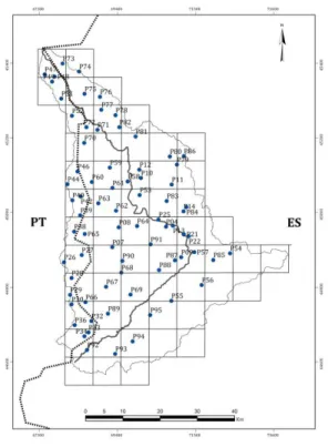
A total of 75 samples of groundwater was collected in the Águeda watershed area along a sampling grid of 7.5 x 7.5 km, during May 2012 (Fig. 1). Water from wells was collected between 1 and 2 m below the waterline. Temperature, pH, ORP, electrical conductivity (EC) and dissolved oxygen (DO) were analyzed “in situ”. Nitrates, phosphates, As, B, Ba, Ca, K, Mg, Mn, Na, Sr and U contents were determined in the Natural Resources and Agro-biology Institute (IRNASA, Salamanca; Spain). Analytical techniques include inductively coupled plasma mass spectrometry (metals and uranium) and atomic absorption (arsenic).
Groundwater’s quality spatial patterns, concerning to metals and metalloids concentrations in groundwater, were constructed using geochemical and geostatistical approaches, using the Geostatistical Analyst of ArcMap 108. U and
As showed a strong association stresses in the performed Principal Components Analysis (Fig.2). Spatial patterns were then represented through a geostatistical interpolation procedure (Gaussian kriging with backtransform algorithm).
Fig. 1. Groundwater sampling points collected in the Águeda River watershed. y - groundwater samples location. PT – Portugal; ES – Spain.
4. Results and Conclusions
The U distribution shows its dependence to the U-mines influence showing hotspots in the central region of the Águeda watershed. Arsenic shows a distinct behavior relative to other trace elements, but a strong association with U, which can be observed in the performed Principal Components Analysis (Fig. 2). The occurrence of these two factors can be associated with mining activities in the region9.
The U distribution map shows that hotspots are mainly concentrated in the central part of the area, which coincide with abandoned mine activities sites (Fig. 3). The As distribution shows a smoother distribution but still with higher values occurring in the central area, also related to their proximity to the mineralization and old mining activities (Fig. 3). However, the smoother arsenic distribution, all along the Águeda watershed area, can be supported by the evidence that arsenopyrite (arsenic sulfide mineral) is not the most relevant mineral of the mineralized veins, and occurring associated with other sulfide minerals, as it has been confirmed in other mine areas10.
In the northern and southern parts of the Águeda watershed it is possible to identify clusters of moderate to high concentrations of U and As, which will be the target of a detailed future study. The obtained results points out of an older mining activity as a serious environmental risk factor.
Gaussian kriging with backtransform algorithm, allowed the interpolation, to the all study area with outliers weight attenuation and final representation in the original variables space, allowing ulterior results validation and subsequently providing a robust tool11 for risk assessment within the study area and therefore allowing the future
Fig. 2. PCA F3-F4 factorial plan.
Fig. 3. Geochemical distribution maps for the Águeda river watershed: (a) Uranium; (b) Arsenic.
Future work will be focused on the evaluation related to the probability of these elements to exceed a specific threshold (e.g., water supply values or background contents10). Groundwater’s temporal characterization is another
issue expected to be overcome with sampling campaigns during the winter season. The definition of seasonal patterns for the contaminant spatial distribution will be useful for determining its dependence with precipitation and infiltration.
Acknowledgements
This research was funded by the POCTEP project “Caracterización ambiental y análisis de riesgos en cuencas transfronterizas: proyecto piloto en el río Agueda” (Ref. CE: 0410_AGUEDA_3_E).
References
1. Gómez P, Garralón A, Buil B, Turrero MJ, Sánchez L, De la Cruz B. Modeling of geochemical processes related to uranium mobilization in the groundwater of a uranium mine. Sci Total Environ 2006; 366: 295-309.
2. Neiva AMR, Carvalho PCS, Antunes IMHR, Silva MMVG, Santos ACT, Cabral Pinto MMS, Cunha PP. Contaminated water, stream sediments and soils close to the abandoned Pinhal do Souto uranium mine, central Portugal. J Geochem Explor 2014; 136: 102-117.
3. Lottermoser BG, Ashley PM, Costelloe MT. Contaminant dispersion at the rehabilitated Mary Kathleen uranium mine, Australia. Environm Geol 2005; 48: 748-761.
4. Lottermoser BG, Ashley PM. Physical dispersion of radioactive mine waste at the rehabilitated Radium Hill uranium mine site, South Australia.
Aust J Earth Sci 2006; 53: 485-499.
5. Kipp GG, Stone JJ, Stetler LD. Arsenic and uranium transport in sediments near abandoned uranium mines in Harding County, South Dakota.
Appl Geochem 2009; 24: 2246-2255.
6. Albuquerque MTD, Sanz G, Oliveira SF, Martínez-Alegría R, Antunes IMHR. Spatio-temporal groundwater vulnerability assessment – a coupled remote sensing and GIS approach for historical land cover reconstruction. Water Resour Manage 2013; 27: 4509–4526.
7. Sánchez-González S, García-Sánchez A, Caravantes P, Rodríguez-Cruz MS, Sánchez-Martín MJ, Rodríguez ISR. Caracterización y análisis de impactos ambientales en la cuenca del rioÁgueda. In: Francisco Campos Sánchez-Bordona, editor. Cuenca del rio Águeda un território para
dos Países. Servicio de Publicaciones. Universidad Europea Miguel de Cervantes Valladolid; 2013. p. 35-64.
8. ESRI. ArcGIS Desktop, Version 9.3. Environmental Systems Research Institute, 329 Washington: Inc. Reedlands; 2004.
9. Seco MFM. 2014 Caraterização ambiental e análise de riscos na bacia hidrográfica do rio Águeda. Msc in Sistemas de Informação Geográfica
em Recursos Agro - Florestais e Ambientais – Especialização em Análise de Informação Geográfica (Unpublished thesis), ESA/IPCB, Castelo
Branco: Portugal; 2014.
10. Antunes IMHR, Albuquerque MTD. Using indicator kriging for the evaluation of arsenic potential contamination in an abandoned mining area (Portugal). Sci Total Environ 2013; 442: 545–552,
11. Saito H, Goovaerts P. Geostatistical interpolation of positively skewed and censored data in a dioxin contaminated site. Environ Sci Techn 2000; 34 (19): 4228-4235.