362
HAIL EPISODES AT METEOROLOGICAL STATION CRAIOVA
DURING THE WARM SEASON
BĂCESCU ADRIANA1
, COLAN MIETTA1, IORDACHESCU MAGDALENA1,
MĂNESCU CARMEN1
, VELEA LILIANA2
ABSTRACT. Hail episodes at meteorological station Craiova during the warm season. The paper presents a statistical, climatological study of the occurrence of hail phenomenon at Craiova- one of the representative stations in Oltenia region – during months May-August in the period 1981-2010. The results show that the month with most hail cases during the period analyzed is June, while the largest frequency of occurrence corresponds to time interval 13:30-14:30 UTC; regarding the dimensions of hail, in most cases the hail particles presented diameters up to 5 mm. From a synoptic point of view, the frequency of thermal convection as trigging factor for hail episodes at Craiova was larger (54%) compared to that of dynamic convection. There are also presented the synoptic and mesoscale conditions which generated this phenomenon in two distinct cases: one generated by thermal convection, observed in 8 June 2013, and the other by dynamic convection, occurred in 14 April 2012. The synoptic and mesoscale conditions during the day of 8 June 2013 favored the occurrence of hail Craiova station due to the weak synoptic forcing and to a relatively warm and wet boundary layer, thus meeting two of the conditions of mass instability. In the second case, the baric configuration at sea level, presenting a low in the west-central basin of Mediterranean, was supported in the middle troposphere, at the 500hPa level, by the presence of a troughextending over most of the Europe, up to the south. The hail was generated, in this case, by the occluded front associated with the Mediterranean depression.
Keywords: hail occurrence, synoptic conditions, thermal and dynamic convection
1. INTRODUCTION
The global warming lead to an increase in the intensity of severe weather phenomena during the last years. One of these is hail – a phenomenon with limited, discreet, spatial and temporal manifestation, but with a significant impact on the socio-economic activity. The damages produced by hail are most important in agriculture, affecting crop yield and/or quality to a degree that depends on the crop species and the phenological time, but they may be significant in other areas too, like transports (e.g. deteriorating the quality of road pavements) or with regard to damages on private property (cars, house roofs).
1
National Meteorological Administration – RFC Craiova, 3A Brestei, Craiova, Romania E-mail: adriana_bacescu@yahoo.com
2
363
The season most favorable for hail occurrence is the warm season, when the mass instability is the largest (Marinică, 2006). The study of hailstorms is based on several meteorological parameters that are involved in conditions required to produce convection (e.g. temperature, instability, a deep humid layer in the low and middle troposphere), as well as on the specific topographic characteristics of the geographical area studied (Dessens, 1995; Johns and Doswell III, 1995; Siemonov and Georgiev, 2003). The hail may be determined by dynamic convection of cold fronts, as well as by thermal convection (mass instability).
In the latter case, the hail is produced by convective clouds formed due to strong insolation over a wet soil during warm season, without being associated with the presence of a cold front. However, there are situations when the dynamic convection superposes over the thermal convection, thus creating the conditions for moist deep convection, when severe hail episodes appear.
The paper presents a statistical study of the occurrence of hail, as well as a synoptic analysis of conditions favoring the occurrence of phenomenon for months May- August during the period 1981-2010 at Craiova, in the south-western part of the country. The meteorological station located in Craiova is one of the representative stations in the Oltenia region, being also included in the international meteorological data flux.
2. DATA AND METHODS
The climatological part of the study employs meteorological data for the months May, June, July and August during the period 1981-2010, available from the quality checked, national database of National Meteorological Administration. The analysis focused on three indices: monthly frequency of hail occurrence, hourly frequency of occurrence and distribution of hail diameter. The dominant conditions favoring the hail occurrence were also investigated, making use of reanalysis data for mean sea-level pressure field, air temperature at 850hPa pressure level and mean geopotential field at 500 hPa, as available from NOOA-NCEP/NCAR (http://www.esrl.noaa.gov).
364
3. RESULTS
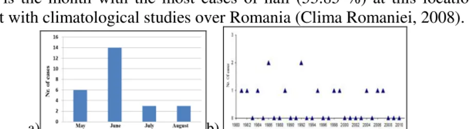
26 hail episodes were identified during months May- August in the period 1981-2010 based on data available at Craiova station (Fig.1). The analysis showed that June is the month with the most cases of hail (53.85 %) at this location, in agreement with climatological studies over Romania (Clima Romaniei, 2008).
a) b)
Fig.1 Hail occurrence at meteorological station Craiova: a) monthly distribution of cases during 1981-2010; b) annual distribution of cases during June 1981-2010.
Analysing the hourly distribution of hail occurence, it may be seen that the largest frequency corresponds to the time interval 13.30-14.30 UTC, this represnetimg 30.76% of the total number of cases identified (Fig. 2a). Figure 2b shows the size distribution of hail as observed at Craiova. It may be seen that in most of the cases the hail had small dimensions – 73,07% of cases with maximum diameter of 5 mm. An exception is noted for the case of 4 August 2006, when the hail dimension reached 30 mm.
a) b)
Fig. 2 a)Hourly frequency of hail occurence at Craiova during May-August 1981-2010
(UTC); b) Size distribution of hail at Craiova during May-August 1981-2010
In order to characterize the conditions of hail occurrence at Craiova station, a series of additional data have been employed: ground synoptic maps (sea-level pressure), geopotential field at 500 hPa, air temperature at 850 hPa.
These data are part of the reanalysis dataset available from NOOA-NCEP/NCAR, for the days when hail was observed at Craiova, in the period of interest. It has been found that:
- The frequency of thermal convection was higher (54%) than that of dynamic convection.
- From the hail episodes generated by convection induced by cold front, 66% were determined by cyclones with mediterranean origins (33% with trans-Balkan trajectory and 33% with T1 trajectories) and the rest were generated by the Icelandic Low.
365
are less intense (Trigo et al, 2002; Campins et al, 2010). Cold advections from northern latitudes may lead sometimes to mediterranean cyclogenesis within Icelandic trough, with a subsequent trans-Balkan trajectory over Romania. In the end, the cold advections induced downward in the tropospheric column determine an additional instability of post-frontal air mass over Romania.
There are cases when the air mass of the warm sector of the cyclone is moist-stable thus favoring, in Oltenia, the producing of lightning, rain showers, hail – which are all phenomena not specific for this cyclonic sector. Such cases are usually found when the cyclone has a T1 -type trajectory (crossing perpendicularly over the Dinaric Alps and Middle Carpathians and then, in diagonal, the Pannonian Plain); in these cases, when the cyclone path intersects the Southern Carpathians, forced ascending movements are generated over a large part of air column, further leading to sudden instability of a significantly large tropospheric layer. The forced upward motions amplify the thermal convection and favor the formation of clouds with strong vertical development as Cumulonimbus (within the warm sector of the cyclone) and the phenomena listed above. Thus, this is just the signature of the orography on the normal air flow.
4. CASE STUDIES
4.1 Thermal convection case: 8 June 2013
In 8 June 2013 at 00 UTC, Western Europe was on the influence of the Azores High, extended until the North-East of Norway Sea (Fig 3.a). The rest of the continent was under the influence of a depression with several nuclei of 1010 mb centered over Gulf of Bothnia, Bay of Biscay and over the Eastern basin of Mediterranean sea. Romania was at the periphery of the depression, with pressure values between 1012 and 1015 mb.
a) b)
Fig.3 a) Sea level pressure and b)Air temperature at 500 hPa, on 8 June 2013 at 00 UTC.
366
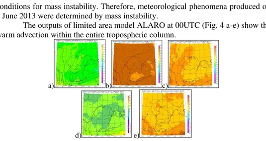
conditions for mass instability. Therefore, meteorological phenomena produced on 8 June 2013 were determined by mass instability.
The outputs of limited area model ALARO at 00UTC (Fig. 4 a-e) show the warm advection within the entire tropospheric column.
a) b) c)
d) e)
Fig. 4. Forecasted fields for 8 June 2013, 09 UTC, of temperature (shaded) and geopotential (thick lines) by ALARO model (run started at 00 UTC) for pressure levels:
a) 300 hPa; b) 500 hPa; c) 700 hPa ; d) 850 hPa; e) 925 hPa.
The numerical forecast valid at 09 UTC indicate the same warm advection in the layers of middle troposphere (700hPa-500hPa) and a cold advection in the near-surface layers ; thus, convection was about to be manifested within this interval.
From the Skew-T diagram produced by COSMO model in the 00UTC run and valid for 08:00 UTC (Fig.5), it may be seen that the sounding corresponds to a case of severe weather. This type of sounding is most common at tropics and it is characterized by a deep moist, conditional unstable, with relative humidity larger than 60% up to a height of 7 km.
Fig. 6. C-band radar images, valid for 8 June 2013, 9:30 UTC for products ETOPS (a) and Fig 5. Skew-T diagram produced by
COSMO model, valid on 8 June 2013, 08:00 UTC (left panel)
CMAX (b)
367
The C-band radar images acquired at Craiova on 8 June 2013 show at 9.30 UTC echoes over 9000 m (Fig 6.a) and reflectivities (CMAX product) up to 53 dBz (Fig. 6 b).
In this context, weather in Craiova was generally unstable. The sky was temporary covered with deep clouds. During the day, there were rain-showers, lightning and small-size hail (2 mm diameter). Total daily precipitation reached 32.4 l/mp. The wind presented weak to medium intensities, with short-time intensifications during rain episodes, the maximum wind gust being of 43 km/h. The daily maximum temperature was 26 deg. Celsius, and the minimum of 15 deg. Celsius.
4.2. Dynamic convection case: 14 April 2012
During 14 April 2012, at the surface, most of Europe was under the influence of vast depression with several nuclei: one situated over central basin of Mediterranean, with a center pressure of 990 mb, another (995 mb) situated over the Gulf of Finland, a third one located in the central basin of Barents Sea and, finally, one located over the Russian Plain (Fig 7. a).
a) b)
Fig.7 a)Synoptic map for Europe on 14 April 2012, 00UTC; b) Air temperature at 500hPa o 14 April 2012, at 00 UTC.
Over the Atlantic Ocean, a belt was formed by the Greenland Anticyclone, from the far north-western part of the continent, and the Azores High located in South-West, while the regions in the far East of the continent were under the influence of the East-European Anticyclonic ridge. Romania was under the influence of the Mediterranean depression, with pressure values between 99de8 and 1005 mb.
In the middle troposphere (Fig. 7b), a vast geopotential trough was influencing most of the Europe, up to the southern basin of Mediterranean, having on each side ridges extended up to north-western and north-eastern parts of the continents, respectively. Romania was under the influence of the anterior part of the trough, with geopotential height between 546 and 556 damgp.
368
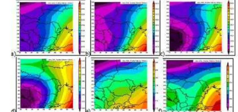
From the mean geopotential field available from NCEP/NCAR at pressure levels of 300 hPa, 500 hPa, 700 hPa, 850 hPa (Fig 8, a-d) for 14 April 2012, it may be seen that the area of interest is on the anterior side of the trough (Fig. 8 a-b) (under the influence of the geopotential nucleus, Fig. 8 c-d) - a structure that is found over the entire tropospheric column.
Fig. 8. Mean field parameters, from NCEP/NCAR, for 14 April 2012: geopotential height at pressure levels: a)300 hPa; b) 500 hPa; c) 700 hPa; d) 850 hPa and air temperature
at pressure levels: e) 850 hPa; f) 500 hPa.
At pressure levels of 850 hPa and 500 hPa (Fig. 8 e - f) on the maps showing the mean air temperature, it may be seen a warm advection in the lower troposphere associated with a cold advection in the middle troposphere. This justifies the presence of occluded front in the vicinity of the area of interest.
The Skew-T diagram produced by NWP model COSMO at 00 UTC and valid for 14 UTC (Fig. 9) shows a sounding similar to the one on 8 June 2013, although in that case the phenomena were produced as a consequence of mass instability.
Fig. 9. Skew-T diagram produced by COSMO model, valid on 14 April 2012, 14:00 UTC
Fig. 10. C-band radar images, valid for 14 April 2012, 8:00 UTC: ETOPS (a),
CMAX(b) and VIL(c) products.
369
values of VIL (Vertically Integrated Liquid water) product of about 4 kg/m2 (Fig. 10c). On 14 April 2012, at Craiova the weather was generally unstable, with temporary deep cloud cover. There were rain showers associated with lightning. Total precipitation cumulated 24 l/mp and hail with 3mm-diameter was also observed. The wind reached medium intensities, with maximum gust speeds of 54 km/h.
a) b)
Fig. 11. Synoptic maps for Europe on 14 April 2012 valid for: a) 12 UTC; b) 18 UTC.
These were the results of the occluded front passing through the area of interest (Fig. 11 a,b).
5. CONCLUSIONS
The hail phenomenon is determined by dynamic and/ or thermal convections. When the two situations are simultaneously present, the consequence is severe hail, due to the deep moist convergence.
At Craiova station, during the months May, June, July and August in the period 1981-2010, most episodes of hail were determined by thermal convection. The highest frequency of days with hail is found for June and for the time interval 13:30-14:30 UTC is the most frequent. The hail with small dimensions (up to 5mm diameter) is most frequent in the data analyzed.
Two case studies were presented, in order to highlight similar conditions for hail occurrence as expressed by instability indices, although generated by different physical mechanism. In 8 June 2013, small size hail was produced by a severe convective storm (supercell), while on 14 April 2012 the severe weather was generated by the occluded front associated with a depression of Mediterranean origin. A decisive role in both cases presented was played by orography.
REFERENCES
1. Administraţia Naţională de Meteorologie (2008): Clima României, Edit. Academiei Române;
2. Bordei, E.I. (2009): Rolul lanţului alpino-carpatic în evoluţia ciclonilor mediteraneeni, Ediţia a II-a, Ed. Printech
370
4. Johns, R. H. and Doswell III, C. A. (1992): Severe local storms forecasting, Weather Forecast, 7, 588–612
5. Marinică, I. (2006): Fenomene climatice de risc în Oltenia, Ed. MJM, Craiova 6. Simeonov, P. and Giorgiev, C. G (2003).: Severe wind/hail storms over Bulgaria
in 1999–2001 period: synoptic- and meso-scale factors for generation, Atmos. Res., 67–68, 629–643, 2003.
7. Trigo, I., Bigg, G.R. and Davies, T. D. (2002): Climatology of Cyclogenesis