PREDICTION OF COLONIZATION BY MACROPHYTES IN
THE YACIRETÁ RESERVOIR OF THE PARANÁ RIVER
(ARGENTINA AND PARAGUAY)
NEIFF, J. J.,1 POI DE NEIFF, A. S. G.,2 PATIÑO, C. A. E.3 and BASTERRA DE CHIOZZI, I.4
1Centro de Ecología Aplicada, Consejo Nacional de Investigaciones Científicas y Técnicas, Casilla de Correo 222, Corrientes (3400), Argentina
2Facultad de Ciencias Exactas, Naturales y Agrimensura, Universidad Nacional del Nordeste y Centro de Ecología Aplicada del Litoral, Consejo Nacional de Investigaciones Científicas y Técnicas de Argentina, Casilla de Correo
291, Corrientes (3400), Argentina
3Centro de Ecología Aplicada, Consejo Nacional de Investigaciones Científicas y Técnicas y Universidad Nacional de Formosa. Casilla de Correo 291, Corrientes (3400), Argentina
4Facultad de Ingeniería, Universidad Nacional del Nordeste, Las Heras 727, Resistencia (3500), Chaco, Argentina Correspondence to: Juan Jose Neiff, Centro de Ecología Aplicada, Consejo Nacional de Investigaciones Científicas
y Técnicas, Casilla de Correo 222, Corrientes (3400), Argentina, e-mail: neiff@arnet.com.ar Received June 22, 1999 – Accepted September 29, 1999 – Distributed November 30, 2000
(With 7 figures)
ABSTRACT
The potential colonization by anchored plants (PCAP) and the potential areas for initial coloniza-tion of free floating plants were estimated during the early filling phase for the Yaciretá reservoir. In order to obtain the PCAP, the observed maximum depth of colonization of the anchored macro-phytes before impoundment and the hypsographic curves were used. The species inhabiting the pre-impoundment area were classified according to the different bioforms before the inclussion in the analysis. The areal extent of PCAP (from depths between 0-4 m) could reach 275 km2 at 76 m above sea level (current water level), whereas at 82 m above sea level (final filling level) the littoral zone will be increased by about 21.5%. The potential area for geophytes was estimated to be 99 km2; 131 km2 for root-floating leaved plants and 120 km2 for submerged plants, at 76 m above sea level. At 82 m above sea level, the geophytes could reach 271 km2. The data for wind frequency, velocity and fetch, together with depth were used to calculate shallow and sheltered areas in which free floating plants could find favourable conditions to initial colonization. Physical and chemical features recorded at eight stations during the early filling phase are discussed in relation to potential plant development.
Key words: tropical rivers, impounding reservoirs, South America, potential macrophytes colonization,
reservoirs.
RESUMO
Predição da colonização por macrófitas no reservatório de Yaciretá do Rio Paraná
120 km2, a 76 m acima do nível do mar. A 82 m acima do nível do mar, as macrófitas emersas poderiam alcançar 271 km2. A informação de freqüência, velocidade de ventos, e de fetch, junto com dados de profundidade foram usados para delimitar áreas rasas e abrigadas, nas quais plantas flutuantes livres poderiam encontrar condições favoráveis para iniciar a colonização. As características físicas e químicas obtidas em oito estações de amostragem no início da formação do reservatório são discutidas em relação ao desenvolvimento potencial das macrófitas.
Palavras-chave:reservatórios, rios tropicais, colonização potencial por macrófitas, barragens, América
do Sul.
INTRODUCTION
Yaciretá is a new man-made lake located on the High Paraná River (27°11’S; 56°20’W), near Ituzaingó (Argentina) and Ayolas (Paraguay), which started operating in September 1994. Its main morphometric characteristics are: length of 66.5 km; surface area of 1.600 km2 at 82 m above sea level; volume of 21,000 hm3; maximum depth of 30 m. Compared with other reservoirs built on the Paraná River (Tundisi et al., 1993) its retention
time is short (< 20 days). The lake area, which was mainly covered by various types of forests, swamps, ponds and peatland soils, was deficiently cleared before the dam was closed. At the moment, Yaciretá is in the first step of the filling phase (actual water level: 76 m above sea level), leading to a planned 82 m above sea level in the future.
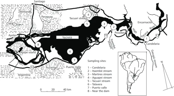
Several small tributaries (minor than 60 m3.s–1) feed the reservoir, but the most important are Garupá, Itaembé and Tacuarí stream.
The objective of this study was to estimate potential areas of the dam that the anchored plants (PCAP) could colonize. The observed maximum depth of colonization of macrophytes presents in the area before the impoundment and the hypso-graphic curves were used in this procedure.
A second objective was to estimate potential areas for the initial colonization for floating plants starting from the morphometry of the reservoir and the predominant winds. The possible development of these plants was analyzed in function of the physical and chemical characteristics registered during the early filling phase of the reservoir.
Limnological data from the High Paraná River prior to the Yaciretá impoundment
Based on the published data available (Varela
et al., 1983; Bonetto, 1986; Bonetto & Lancelle,
1981), the water of the Higher Paraná River was characterized by a high turbidity and colour during floods (Secchi disk ≅ 0.8 m), but these parameters drop when the flow becomes low (Secchi disk ≅ 1.30 m). Maximum water temperature (30°C) is reached in February. Then, the temperature de-creases to a minimum (15°C) in late July. The Paraná River surface water is generally well sup-plied with dissolved oxygen, with values near sa-turation. The pH tends to be neutral ranging from 7-7.5. The average ionic composition by equiva-lents indicates the overall importance of bicar-bonate calcium and magnesium. Conductivity shows a relationship with the flow regime but remains near 100 µScm–1.
The lotic environments of the High Paraná are relatively low in species richness and abundance of aquatic plants (Neiff, 1986a), due to high current velocities, steep banks and a deep channel of va-riable width. Podostemaceae occur only in the areas of rapids, where they tolerate current speeds of 2-3 m.s–1.
Downstream of Puerto Candelaria (Fig. 1) the river originates several islands of 5-20 km2 area which are 15 m above the mean water level. Only the High parts of the Yaciretá islands remain emer-ged now after the impoundment. Other areas, such as the Talavera island and the lower parts of the Yaciretá islands, with extensive regions of swamps and peatlands, were covered by waters.
spp.), while the geophytes (Cyperus giganteus, Typha latifolia, Thalia multiflora) are dominant
in swamp and lake areas coupled sporadically by the river dynamics, reaching a height of 2.5 m and developing a continuous canopy for several km.
Aquatic submerged plants, such as Cera-tophyllum demersum, Najas marina, Utricularia foliosa and Cabomba australis, and root-floating
leaved plants (Nymphoides indica, Victoria cru-ziana) are dominant in island ponds with soft
bot-tom sediments.
Santiago
Paraguay
Yaciretá Ayolas
Apipé island
AñaCuá branch
5 3
2
12
12
12 1 Candelaria 8
7 6
Tacuarí stream 4
Itaembé stream
Posadas
High
Paraná
River
Garupá
stream
N
Encarnación
Argentina
Ituzaingó Puerto Valle
0 20 40 km
Sampling sites:
1 – Candelaria 2 – Itaembé stream 3 – Martires stream 4 – Aguapei stream 5 – Tacuarí stream 6 – Talavera 7 – Puerto valle 8 – Near the dam Wetlands
Fig. 1 — Location of the sampling sites in the Yaciretá dam and high Paraná River.
Pioneer forests on sand banks were domi-nated by a very dense gallery of Salix humbol-dtiana, and Croton urucurana was also present.
In tall levees, the plurispecific forest reaches 10-12 m height and 0.9 m of diameter at breast heigh (DBH), with Nectandra membranacea var. falci-folia, Ocotea acutifolia and Myrceugenella apiculata as the more frequent species. The high
position of the topographic gradient is occupied by a tall forest of up to 15-20 m, with 18 tree species (Piptadenia macrocarpa, Tabebuia ipe and Peltophorum vogelianum, among others).
METHODS
In order to obtain the potential areal colo-nization by anchored plants (PCAP), the macro-phytes inhabiting the Yaciretá preimpoundment area (Neiff, 1986a, 1986b) were classified
accor-ding to the different bioforms. For each bioform, maximum and minimum depth in which the plant grew, were defined.
The potential areal extent of the littoral zone in which the rooted plants could colonize depends on two morphometric features of the lake: the shore development, which is the relationship between
the shoreline of the lake and its area, compared with the circumference of a circle that has the same area as the lake, and the slope of the shore. Both
were obtained directly using a Kontron planimeter. The flooded areas at different depths were computed using the Geographic Information Sys-tem IDRISI (Fig. 2).
To know if the physical and chemical con-ditions of the water could favour the macrophytes grow, the following environmental parameters were recorded: water temperature; electric conductivity; dissolved oxygen (in profiles); transparency (mea-sured using a Secchi disk); chemical parameters [pH, ionic concentration, nutrient concentration (nitrate + nitrite, ammonia, total phosphorus)].
Water samples were collected for eight sta-tions (Fig. 1) between July 1994 and January 1995 (early filling phase). Station 1 was located on the High Paraná River above the Yaciretá reservoir. Stations 2, 3, 4 and 5 were placed at the mouths
of the tributaries. Station 6 was located over the oldest Talavera island. Station 7 was greatly in-fluenced by winds, and Station 8 was placed in the lake near the dam.
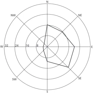
Climatological data (Fig. 3), collected bet-ween 1960 and 1995, were provided by a meteoro-logical station located in Ituzaingó City, on the right bank of the impoundment. The potential effect of the wind on the water surface was estimated from satellite images, considering the frequency and velocity of the wind and the distance over which the wind had blown without being inter-rupted by land (fetch).
68 69 70 71 72 73 74 75 76 77 78 79 80 81 82 600
800 1,000 1,200 1,400 1,600 1,800
Meters above sea level
Floded
area
(km
)
2
Fig. 2 — Flooded area between 68 and 82 m above sea level during filling phase.
32 24 16 8
S N
NW
W E
NE
SW SE
We also defined accumulationareas as sites in which the wind tends to gather the plants together (e. g. free-floating and sudd hydrophytes). These zones are important because a quick succession could produce true floating islands in the lakes existing before the filling of the Yaciretá reservoir in a very short time (Neiff, 1986a, 1986b; Cuadrado & Neiff, 1993).
RESULTS
From the planimetric map, the form index
(ratio between the area of the reservoir and its perimeter) was similar to 0.2 in both filling phases (76 and 82 m above sea level).
Fluctuation in the water level of the lake was expected to be of small amplitude (< 1.5 m), com-pared to the Paraná River before the impoundment (5 m in Puerto Posadas, Argentina).
The main physical and chemical characte-ristics of the water during the early filling phase are summarized in Table 1.
During the study period, the hydrological regime of the High Paraná River was characterized by floods in July – September 1994 and low water phases in January 1995. The river water turbidity was most pronounced during flood (Table 1B), at which time the Secchi disk dropped to about 0.35 m. At low waters there was an increase in the transparency (Secchi disk 0.7-1.9 m).
Initial deoxygenation of the lake was much less pronounced than that expected from infor-mation from other tropical reservoirs (Van der Lingen, 1973; Van der Heide, 1982; Barrow, 1987; Junk & de Mello, 1987; Tundisi et al., 1993) and
oxygen concentrations on the water surface never dropped below 63% saturation (Table 1).However, during stratification, deoxygenation of water occur-red at lacustrine regions, and oxygen concentrations in the lower layer dropped to < 1 mg.L–1. Surface concentrations remained below 15% saturation (Table 1).
The total mineral content of surface waters was low. At the sampling sites, conductivity ranged from 39 to 75 µS.cm–1. The average ionic com-position was characteristic of calcium-bicarbonated waters. The order of dominance for cations and anions was similar to that of the river prior to the impoundment. However, potassium was an excep-tion, reaching relatively high concentrations at
Stations 2, 3 and 6 during September. Concen-trations of nitrogen (nitrate + nitrite) and total phosphorus in the water were low (Table 1).
The water temperature (Table 1), of the lake, recorded at different stations, oscilated between 17.7°C (winter) and 29.5°C (summer).
Potential areal colonization by anchored plants (PCAP)
There were no geophytes (Typha spp., Scirpus californicus) which could colonize the
preimpoun-dment area below 1.5 m depth, and the root-floating leaved plants (Victoria cruziana, Nymphaea spp., Nymphoides indica) were found until a depth
boun-dary of 3.5 m. In order to include the annual water fluctuation, half meters were added in both cases. So, the boundary of the geophytes potential zone
was established at 2 m depth, and the root-floating leaved plants potential zone,at 4 m depth (Table
2). In the lakes of islands prior the Yaciretá im-poundment the submersed plants usually grow to depths of less than four meters (Table 2). This depth was taken as maximum depth for the co-lonization for submerged plants.
Therefore, the potential areal colonization by anchored plants (PCAP) included the portion of the litoral zones that comprehended 0-4 m of depth. The areal extent of this reach 275 and 350 km2 at 76 and 82 m above sea level respectively. The po-tential area for Geophytes was estimated to be 99 km2; 131 km2 for root-floating leaved plants and 120 km2 for submerged plants, at 76 m above sea level (current water level). At 82 m above sea level (final water level), the potential area colonized by geophytes could reach 271 km2 (Table 3).
The bottom of the lake has lime/clay sedi-ments in the shore line with 8% of organic matter (Paggi et al., 1998). Except in the Station 8, which
has emergent basaltic blocks as substrate, there are not restrictions for the rooting of the macro-phytes in the shore line.
Estimation of areas for initial colonization by free floating plants
TABLE 1
Physico-chemical characterization of the surface water at eigth sampling sites in Yaciretá dam during the early filling phase.
A: High Paraná River at low water B: High Paraná River at high water
A
Station 1
(July, 1994)
Station 2
(Sep., 1994)
Station 3
(Sep., 1994)
Station 4
(July, 1994)
Station 6
(Sep., 1994)
Station 7
(July, 1994)
Station 8
(July, 1994)
Water temperature (°C) 18 18.2 20 19 20 18 17.7
Dissolved oxygen (mg.L–1
) 9.8 6.5 7.2 9.2 6.2 8.8 8.2
Conductivity (µS.cm–1) 45 42 70 53 39 40 45
pH 7.1 6.5 7 5.6 7.1 7.2 7
HCO3– (mg.L–1) 21.5 18 20 20 19 21 21
Ca2+ (mg.L–1
) 4 1.8 2.1 1.8 1.9 3.9 4.4
Mg2+ (mg.L–1) 1.5 1.5 1.5 1.4 1.5 1.2 1.9
Cl– (mg.L–1) 1.9 1.8 2 2.5 1.8 2 2.2
Na+ (mg.L–1) 0.87 1.9 2.2 – 2 0.83 0.87
K+ (mg.L–1) 0.5 3.5 3.5 – 3.5 0.5 0.6
SO42– (mg.L–1
) 0.3 3.5 3.5 0.3 3.5 0.3 0.3
NO3– + NO2– (µg.L–1) 405 75 165 75 215 405 390
NH4+ (µg.L–1
) no det. 20 20 33 10 14 14
P total (µg.L–1) 44 20 18 20 16 44 44
Secchi disk (cm) 98 70 70 – 70 90 92
B
Station 1
(Jan., 1995)
Station 2
(Jan., 1995)
Station 4
(Jan., 1995)
Station 5
(Jan., 1995)
Station 6
(Jan., 1995)
Station 7
(Jan., 1995)
Station 8
(Jan., 1995)
Water temperature (°C) 27 29.5 26.5 27 28.5 28 28
Dissolved oxygen (mg.L–1
) 8.7 4.8 8.5 8.2 7.4 7.7 7.9
Conductivity (µS.cm–1) 54 60 50 50 59 47 49
PH 7.4 6.5 6 6 7.3 7 7.2
HCO3– (mg.L–1
) 23 – – – – 20 20
Ca2+ (mg.L–1) 4.28 – – – – 4.06 4.28
Mg2+ (mg.L–1
) 1.56 – – – – 1.43 1.30
Cl– (mg.L–1) 2.5 – – – – 2.5 2.4
Na+ (mg.L–1
) 0.8 – – – – 0.8 0.8
K+ (mg.L–1) 0.5 – – – – 0.6 0.6
SO42– (mg.L–1) 0.3 – – – – 0.3 0.3
NO3– + NO2– (µg.L–1) 196 – 315 358 352 114 103
NH4+ (µg.L–1) 58 10 8 8 10 39 52
P total (µg.L–1) 48 47 47 46 43 46 40
Bioforms Depth (in meters) > Frequency in a belt of:
Sites
A: Anchored plants
A-1: Geophytes
0-0.5-1 1-1.5-2 2-2.5-3 3.5-4-4.5
Typha latifolia (*) --- --- -- 0.5-1.5 2, 4
Schoenoplectus californicus californicus
--- --- - - 0.0-1.2 5
Cyperus giganteus - - --- - - 0.5-1.0 4, 5
Thalia geniculata --- - - - - 0.2-0.9 4
Thalia multiflora --- - - - - 0.3-0.9 4
Sagittaria montevidensis --- - - - - 0.0-0.8 2, 3, 7
Pontederia lanceolata - --- - 0.1-0.5 2, 3, 7
Bacopa sp. -- 0.0-0.1 7
Enhydra anagallis - - --- - - 0.3-1.0 4, 5
Echinochloa helodes (*) --- - - 0.5-1.0 2
Panicum grumosum 0.5-1.5 2, 5
Paspalum repens (*) --- --- 1.0-2.0 1, 2, 3, 7
Polygonum punctatum --- - - - - - 0.1-1.0 2, 3, 5, 7
P. acuminatum - - ---- --- - - - - - - - 0.5-1.2 4, 5, 7
Althernanthera phyloxeroides
- ---- - - - 0.3-1.0 2, 7
Hymenachne amplexicaulis 0.1-0.5 4, 5
A-2: Floating leaved plants
Nymphaea amazonum - - - --- --- - - - 1.0-2.5 2, 3
Nymphoides indica ---- --- --- - - 1.5-2.8 3, 5
Hydrocleis nymphoides - ---- - 0.2-0.6 2
Myriophyllum brasiliense - --- --- - - - 0.6-1.3 3, 4
Eichhornia azurea - - --- --- --- - - - - 2, 3, 4, 5, 7
Ludwigia peploides --- --- --- - - - - - 1.0-2.5 2, 3, 4, 5, 7
A-3: Submerged plants
Potamogeton berteroanus - --- - - - - - - - - 1.3-2.5 2, 3, 4, 5, 7
Potamogeton pectinatus - --- - - - - 1.5-2.5 2, 3, 4, 5, 7
Cabomba australis - - --- -- --- --- - 1.5-3.0 5
Egeria naias - - - --- --- 2.0-4.0 5
Nitella sp. - - --- - - - - - - 1.2-2.1 5
B:Free plants
B-1: Floating plants
Spirodella intermedia Lemna spp.
wide range 4, 5, 7
line indicates the depth range for the species in lakes and rivers near the Yaciretá dam (record = 66 environments since 1980).
--- = abundant. - - - - = scarce.
Sites: 1-8 are the observation points in the Yaciretá basin (see: Fig. 1).
TABLE 2
TABLE 2 (Continued)
Bioforms Depth (in meters) > Frequency
in a belt of:
Sites
Ricciocarpus natans Wide Range 4, 5, 7
Azolla caroliniana Wide Range 4, 5
Salvinia herzogii Wide Range 3, 7
Pistia stratiotes Wide Range 2, 3, 4, 7
Limnobium laevigatum Wide Range 2, 4
Eichhornia crassipes Wide Range 2, 3, 4, 5
B-2: Submerged plants
Utricularia foliosa - - - --- - - - 2.0-3.0 4
C: Epiphytes(growing over
other plants)
not related to depth Spp. With (*) in A-1 (see
above)
not related to depth
Hydrocotyle ranunculoides not related to
depth 3, 4, 5 7
Ludwigia repens not related to
depth 3, 5
Scirpus cubensis var. paraguaayensis
not related to
depth
2,3,4,5,7
Bidens laevis not related to
depth 4, 5
Senecio bonariensis not related to
depth
5
indicates the depth range for the species in lakes and rivers near the Yaciretá dam (record = 66 environments since 1980).
--- = abundant. - - - - = scarce.
Sites: 1-8 are the observation points in the Yaciretá basin (see: Fig. 1).
Bioforms Depth range (m) 76 m above sea level (km2) 82 m above sea level (km2) Area 82-76
Geophytes 0.2-2.0 99 271 +172
Root leaved 1.0-4.0 131 134 +3
Submerged 1.5-4.0 120 105 –15
PCAP 0-4.0 275 350 +75
TABLE 3
Potential areas that could be occupied for different bioforms after two philling phases.
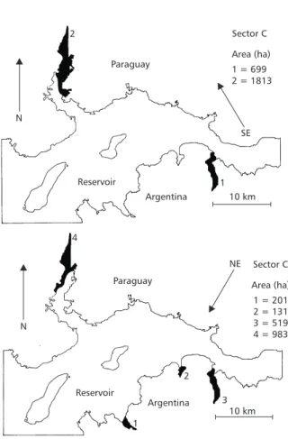
With values of fetch less than four kilometers and depth less than two meters, we estimated the areas comprissed in the Figs. 5, 6 and 7 for pre-dominant winds.
These areas reach 25.12 km2 for predominant winds of southeast and 18.34 km2 for northeast winds at water elevation of 76 m above the sea level (Fig. 5). With the reservoir at water elevation of 82 m above sea level, the areas for initial
No significant input of free-floating plants should be expected from the tributaries of the Yaciretá reservoir because of the physiography of its basins (including the High Paraná River). Ho-wever, these inputs are important as “seedings” in the areas for initial colonization.
Final remarks
The observed maximum depth of anchored plants in a pre-impoundment conditions should provide a reasonable estimate of the areal extent of the zone that different bioforms of macrophytes could be colonized. The results found in this study allow as to conclude that the area occupied by the littoral zone will be increased by 21.5% at the end of the filling phase (water elevation of 82 m above
sea level). In this way, the geophytes would occupy an area proportionally more extensive than other bioforms of plants due to the increase in shallow waters at this water elevation.
Since the maximum depth of colonization by aquatic submersed macrophytes depend on the changes in the transparency, the calculated areas will be adjusted by employing a predictive model developed by Canfield et al. (1985) that involves
the Secchi disk reading. With the current values of transparency (early filling phase), the maximum depth of colonization using Canfield’s equation could be reach to 2.5 m. If the transparency remains low for several years, the area colonized by sub-merged plants would be smaller than the predicted for observed maximum depth.
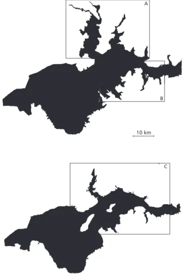
A
B
10 km
C
If the transparency increase (i. e. Secchi disk value of 1.9 m) the maximum depth of colonization estimated by Canfield’s equation could be reach 3.36 m, which is very close to the value used in the PCAP prediction.
Colonization of the free floating macrophytes in man-made lakes is related with many variables. Among there were: light, nutrient content, morpho-metry, wind speed and direction. In the case of Yaciretá reservoir, light and temperature were probably adecuate for free floating plant growth according to the report from african reservoirs (Bond & Roberts, 1978; Allanson et al., 1990).
Experience in several tropical lakes (Thorn-ton, 1987; Bond & Roberts, 1978) has indicated a poor correlation between plant growth rates and water nutrients content. Therefore we cannot to discard a possible explosive growth of the po-pulations of floating plants being based only on the low nutrient content in the early filling phase.
In fact, Eichhornia crassipes, Salvinia herzogi, Pistia stratiotes and other free-floating plants were
frequently found in the tributaries and several places of the littoral zone. Floodplain lakes enri-chment plants (Carignan & Neiff, 1992) showed that nitrogen is the plant nutrient most likely to limit the growth of Eichhornia crassipes.
There-fore, an input of nitrogen could favour the free-floating plant growth. A preventive program is necessary for a rational management of the higher basin, because eutrophication, erosion and other impacts from the marginal cities would probably increase the nitrogen levels in the Yaciretá reservoir favouring, in this way, the plant growth.
But growth rates and quantities of floating plants in a features stages of the lake remain um-predictible. Despite of these, analyses of wind and fetch in relation to morphometry allows usefull predictions of initial points of colonization of plants.
Paraguay
Paraguay
Sector C
Sector C Area (ha) 1 = 699 2 = 1813
Area (ha)
1 = 201 2 = 131 3 = 519 4 = 983 10 km
10 km Reservoir
Argentina
Argentina
NE
N
1
1
2 2
3 4
N
SE
Reservoir
Reservoir
Sector B
Sector A
Area (ha) 1 = 387 2 = 1176 3 = 540 4 = 228
Area (ha) 1 = 948 2 = 976 3 = 913 4 = 284
SE
SE
10 km Argentina
1 1
2 2
3 3
4
4 N
Reservoir Paraguay
7 6
5
N
Paraguay
NE
Sector A Area (ha) 1 = 415 2 = 138 3 = 422 4 = 138 5 = 83 6 = 934 7 = 906
Reservoir
Reservoir Sector B
Area (ha) 1 = 671 2 = 2104 3 = 1010 4 = 477 5 = 678 N
NE
3
5
2 1
Argentina 10 km
3
1 2
4
Fig. 6 — Potential areas for initial floating planst colonization for SE prevailing winds. Reservoir at 82 m a.s. l.
Acknowledgments — Financial support was partially provided by EBY (Entidad Binacional Yaciretá) and CONICET (Conse-jo Nacional de Investigaciones Científicas y Técnicas), Ar-gentina.
REFERENCES
ALLANSON, B. R., HART, R. C., O’KEEFFE, J. H. & ROBARTS, R. D., 1990, Inland waters of Southern Afri-ca: an Ecological Perspective, Kluwer Acad. Publ., The Netherlands, pp. 221-284.
BARROW, C. J., 1987, The environmental impacts of the Tu-curuí reservoir on the middle and lower Tocantins River Basin Brazil. Regulated River, 1: 49-60.
BOND, W. S. & ROBERTS, M. G., 1978, The colonization of Cabora-Bassa Mozambique, a new man-made lake by floating aquatic macrophytes. Hydrobiologia, 60: 243-259.
BONETTO, A. A., 1986, The Paraná River System. pp. 541-551. In: K. F. Walker & B. R. Davies (eds.), The Ecology of River Systems. Dr. W. Junk Publishers, The
Nether-lands, Dordrecht, 541-551.
BONETTO, A. A. & LANCELLE, H. G., 1981, Calidad de las aguas del Río Paraná medio. Principales caracterís-ticas físicas y químicas. Comunic. Científicas CECOAL, 11: 1-22.
CANFIELD, D. E., LANGELAND, K. A., LINDA, S. B. & HALLER, W. T., 1985, Relations between water trans-parence and maximum depth of macrophytes coloniza-tion in lakes. Jour. Aquat. Plant. Management, 23:
25-28.
CARIGNAN, R. & NEIFF, J. J., 1992, Nutrient dynamics in the floodplain ponds of the Paraná River (Argentina) do-minated by the water hyacinth Eichhorniacrassipes. Bio-geochemistry, 17: 85-121.
CUADRADO, G. & NEIFF, J. J., 1993, Palynology of em-balsados in distrophic lakes in Northeastern Argentina.
Rev. Brasil. Biol., 53(3): 443-451.
JUNK, W. J. & de MELLO, J. A. N., 1987, Impactos ecoló-gicos das represas hidrelétricas na bacia amazônica bra-sileira, pp. 367-385. In: G. Kohlhepp & A. Schrader
(eds.), Homem e Natureza na Amazônica. Tübinger
Geo-graphische Studien 95 (Tübinger Beiträge zur Geogra-phischen Lateinamerika-Forschung 3). Geographisches Institut, Universität Tübingen, Tübingen, Germany, 507p.
NEIFF, J. J., 1986a, Aquatic plants of the Paraná System, pp. 557-571. In: K. F. Walker & B. R. Davies (eds.), The Ecology of River Systems. Dr. W. Junk Publishers, The Netherlands, Dordrecht.
NEIFF, J. J., 1986b, Las grandes unidades de vegetación y ambiente insular del Tío Paraná en el tramo Candelaria-Itá Ibaté. Rev. Asoc.Cienc. Nat. Litoral, 17(1): 7-30. NEIFF, J. J., 1996, Large rivers of South America. Toward
the new approach. Verh. Internat. Verein. Limnol., 26: 167-180.
NEIFF, J. J. & POI de NEIFF, A. S. G., 1979, Estudios suce-sionales en los camalotales chaqueños y su fauna aso-ciada. I. Etapa seral Pistia stratiotes-Eichhornia cras-sipes. Physis, B-37(95): 29-39.
PAGGI, A. C., CESAR, I. I. & RODRIGUES CAPITULO, A., 1998, Benthic studies in the zone of islands of Yacy-retá prior to impoundment of the Upper Paraná River (Argentina). Verh. Internat. Verein. Limnol., 26:
1089-1094. Stuttgart.
THORNTON, J. A., 1987, Aspects of eutrophication mana-gement in tropical-subtropical regions. J. Limnol. Soc. Sth. Afr., 13(1): 25-43.
TUNDISI, J. G., MATSUMURA-TUNDISI, T. & CALIJURI, M. C., 1993, Limnology and Management of Reservoirs in Brazil, pp. 25-55. In: M. Straškraba, J. G. Tundisi & A. Duncan (eds.), Comparative Reservoir Limnology and Water Quality Management. Kluwer Academic Publ., The Netherlands.
VAN DER HEIDE, J., 1982, Lake Brokopondo: Filling phase limnology of a man-made lake in the humid tropics. Ph.
D. Diss., U. Amsterreservoir.