HIGHLANDS OF THE UPPER JEQUITINHONHA
VALLEY, BRAZIL. I – CHARACTERIZATION AND
CLASSIFICATION
(1)Fábio Henrique Alves Bispo(2), Alexandre Christofaro Silva(3) & Pablo Vidal Torrado(4)
SUMMARY
In the upper Jequitinhonha valley, state of Minas Gerais, Brazi, there are large plane areas known as “chapadas”, which are separated by areas dissected by tributaries of the Jequitinhonha and Araçuaí rivers. These dissected areas have a surface drainage system with tree, shrub, and grass vegetation, more commonly known as “veredas”, i.e., palm swamps. The main purpose of this study was to characterize soil physical, chemical and morphological properties of a representative toposequence in the watershed of the Vereda Lagoa do Leandro, a swamp near Minas Novas, MG, on “chapadas”, the highlands of the Alto Jequitinhonha region Different soil types are observed in the landscape: at the top - Typic Haplustox (LVA), in the middle slope - Xanthic Haplustox (LA), at the footslope - Xanthic Haplustox, gray color, here called “Gray Haplustox” (“LAC”) and, at the bottom of the palm swamp – Typic Albaquult (GXbd). These soils were first morphologically described; samples of disturbed and undisturbed soils were collected from all horizons and subhorizons, to evaluate their essential physical and chemical properties, by means of standard determination of Fe, Al, Mn, Ti and Si oxides after sulfuric extraction. The contents of Fe, Al and Mn, extracted with dithionite-citrate-bicarbonate and oxalate treatments, were also determined. In the well-drained soils of the slope positions, the typical morphological, physical and chemical properties of Oxisols were found. The GXbd sample, from the bottom of the palm swamp, is grayish and has high texture gradient (B/A) and massive structure. The reduction of the proportion of crystalline iron compounds and the low crystallinity along the slope confirmed the loss of iron during pedogenesis,
(1) Part of the dissertation of first author, presented to the Master’s degree in Produção Vegetal of the Universidade Federal dos Vales do Jequitinhonha e Mucuri – UFVJM. Received for publication in October 28, 2010 and approved in May 6, 2011. (2) Fellow ship of the Núcleo de Inovação Tecnológica – UFVJM. Rodovia MGT 367, Km 583, CEP 39100-000 Diamantina (MG).
E-mail: [email protected]
(3) Associate Professor, Departamento de Engenharia Florestal, UFVJM. E-mail: [email protected]
(4) Full Professor, Departamento de Ciência do Solo of the Escola Superior de Agricultura Luiz de Queiroz –ESALQ/USP. PO Box 09, Avenue Pádua Dias 11, CEP 13418-900 Piracicaba (SP). E-mail: [email protected]
DIVISÃO 1 - SOLO NO ESPAÇO E NO TEMPO
which is reflected in the current soil color. The Si and Al contents were lowest in the “LAC” soil. There was a decrease of the Fe2O3/TiO2 ratio downhill, indicating
progressive drainage restriction along the toposequence. The genesis and all physical and chemical properties of the soils at the footslope and the bottom of the palm swamp of the “chapadas” of the Alto Jequitinhonha region are strongly influenced by the occurrence of ground water on the surface or near the surface all year long, at present and/or in the past. Total concentrations of iron oxides, Fed
and Feo in soils of the toposequence studied are related to the past and/or present
soil colors and drainage conditions.
Index terms: Haplustox, Albaquult, morphology.
RESUMO: SOLOS EM TOPOSSEQUÊNCIA DE VEREDAS DAS CHAPADAS DO ALTO VALE DO JEQUITINHONHA, MG. I - CARACTERIZAÇÃO E CLASSIFICAÇÃO
No Alto Vale do Jequitinhonha - MG ocorrem extensas áreas de relevo aplainado denominadas de “chapadas”, que estão separadas por áreas dissecadas pelos rios Jequitinhonha e Araçuaí e seus afluentes. Nessas áreas dissecadas é encontrado um sistema de drenagem superficial com vegetação arbóreo-arbustiva e gramíneas, comumente denominado de “vereda”. O objetivo deste estudo foi caracterizar física, química e morfologicamente os solos de uma topossequência da microbacia da Vereda Lagoa do Leandro, representativa das veredas das chapadas do Alto Jequitinhonha, localizada no município de Minas Novas - MG. Os solos estudados ocupam as seguintes posições na vertente: topo - Latossolo Vermelho Amarelo (LVA); terço médio da vertente - Latossolo Amarelo (LA); sopé - Latossolo Amarelo, de cor cinzenta, aqui denominado “Latossolo Acinzentado” (“LAC”); e base da vereda - Gleissolo Háplico (GXbd). Esses solos foram descritos morfologicamente e foram coletadas amostras deformadas e indeformadas em todos os horizontes e sub-horizontes para realização das análises físicas e químicas de rotina, determinação de óxidos de Fe, Al, Mn, Ti e Si após extração por ataque sulfúrico e determinação dos teores de Fe, Al e Mn extraídos por ditionito-citrato-bicarbonato e oxalato. Os solos das posições bem drenadas da vertente apresentaram atributos morfológicos, físicos e químicos típicos da ordem dos Latossolos. Na base da vereda encontra-se o GXbd, que apresenta cores acinzentadas, elevado gradiente textural B/A e estrutura maciça. A diminuição do teor de Fe cristalino e de baixa cristalinidade ao longo da vertente confirmou a perda de Fe durante o processo de pedogênese e refletiu na cor dos solos. Os teores de Si e Al foram mais baixos no “LAC”. Verificou-se diminuição da relação Fe2O3/TiO2 vertente abaixo, indicando
impedimentos à drenagem ao longo da topossequência. A gênese e os atributos dos solos do sopé e da base das veredas das chapadas do Alto Vale do Jequitinhonha - MG são fortemente influenciados pela presença do nível freático na superfície ou próximo à superfície o ano todo, no presente e, ou, no passado. Os teores totais de óxidos de Fe, Feo e Fed dos solos da topossequência
estudada estão relacionados com as cores dos solos e com condições de drenagem presentes e,ou, pretéritas.
Termos de indexação: Latossolos, Gleissolos, morfologia.
INTRODUCTION
Veredas are typical superficial drainage subsystems of the Brazilian Cerrado, with tree and shrub vegetation growing along the borders and herbaceous plants at its base. They form slightly depressed landscapes that regulate the hydrological cycle of landforms called chapadas (highlands), rather common in Central Brazil. The regenerative
capacity in this environment is low (Carvalho, 1991) and highly sensitive to anthropic changes (Melo, 1992).
Basic conditioning factors for a typical vereda are: a planation surface, a permeable layer overlying an impermeable layer, local base levels, and flowing conditions (exorheism), as well as a tropical climate (Boaventura, 1981).
Extensive planation surfaces (chapadas) are common in the upper Jequitinhonha valley, ranging from 10,000 to 40,000 ha; these areas are mostly used for eucalyptus or pastures. Latosols predominate on these chapadas, and have been characterized and classified by Ferreira et al. (2010) as Red Latosol (Rhodic Haplustox), Red Yellow Latosol (Typic Hplustox), Yellow Latosol (Xhantic Haplustox), and Greyish Latosol (also called Gray Haplustox).
Depressions forming small hydrographic basins with veredas along the base may be found on planation surfaces of the Upper Jequitinhonha valley; these comprise the headwaters of the watercourses in the chapada regions. Data characterizing the soils of these depressions in detail are not available in the literature.
The purpose of this study was to classify and characterize the morphology, physics and chemistry of soils in a representative toposequence of a vereda on a chapada in the Minas Novas region, which is located in the Upper Jequitinhonha valley, Minas Gerais State, Brazil.
MATERIAL AND METHODS
Characterizing the environment
The study area is located in the municipality of Minas Novas, in the Upper Jequitinhonha valley, Minas Gerais, Brazil (bordering coordinates from latitudes 17º 19’ S to 17° 20’ S, and longitudes 42 º 28 ’ W to 42 ° 29 ’ W (Figure 1); altitude from 810 to 870 m asl).
On the Jequitinhonha plateau, there are plane areas that are fragmented by intense dissection of the landscape and underlain by the lithology of the Ribeirão da Folha Formation (belonging to the Macaúbas Group); these are known as chapadas, found at a mean altitude of about 900 m. A deep pedological coverage on chapadas facilitates water infiltration, part of which supplies the deep water table at the regional base level, and part rises to the surface in localized occurrences of surface flows in the lower areas of chapadas; these headwaters are commonly named veredas (Projeto RADAMMINAS, 1977).
The regional climate is Aw – semiarid to subhumid/ humid – according to Köppen’s classification system. The mean annual temperature ranges from 21 to 24 C. The mean annual rainfall ranges from 600 to 1,200 mm (annual mean – 1,062 mm) and rains occur during six months (October to March). The relative
air humidity ranges from 60 to 80 %. Potential evapotranspiration ranges from 800 to 1,200 mm (Brasil, 1997). The planting of eucalyptus forests started in the 1970s and has replaced the strictu sensu
Cerrado vegetation.
Field work
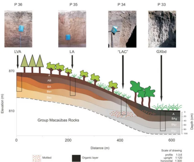
Four profiles representing the landscape (top, middle slope, foot slope, and base of the vereda) were described in a toposequence on the hillside of the Lagoa do Leandro microbasin in the Upper Jequitinhonha valley.
The soil profiles were described and characterized morphologically, according to Santos et al. (2005). Deformed and non-deformed samples were obtained of all horizons and sub-horizons in each profile for chemical, physical and morphological tests. These results were the basis for classifying the soils according to the Brazilian Soil Classification System, Sistema Brasileiro de Classificação de Solos - SiBCS, (Embrapa, 2006) and Soil Taxonomy (EUA, 1975).
The lateral configuration of soil horizons in the study toposequence was analyzed using Boulet et al. (1982) method. Boreholes were drilled every 20 m along 600 m of the study toposequence to observe the horizontal and vertical distribution of horizons. The morphological properties of horizons were compared to draw vertical and horizontal toposequences.
Laboratory work Physical analysis
Pipette analysis was used for particle size distribution. An Uhland sampler was used to obtain non-deformed samples to measure soil packing/ bulk density by the volumetric ring method. Particle density or soil compaction was measured using three repetitions of the volumetric rubber balloon method. The total pore volume was then calculated. The physical analyses were done according to Embrapa (1997).
Chemical analysis
In routine chemical analyses, the water and KCl contents, pH, organic matter (OM), P, sorptive complex elements, and total acidity were determined, according to methods proposed by Embrapa (1997).
The Fe2O3, Al2O3, TiO2, SiO2, and MnO contents were measured following treatment with 1:1 H2SO4 (volume – sulphuric acid attack). SiO2 was extracted from the residue with NaOH, as described by Embrapa (1997); all oxides were measured by atomic absorption spectrophotometry. Fe, Al, Ti, Si, and Mn were read, respectively, at 518, 534, 381, 655.5, and 279.5 nm.
Low crystallinity (amorphous) forms of Fe, Al, and Mn were extracted using the acid-ammonium oxalate method (OAA) at pH 3.0 (McKeague & Day, 1966; Schwertmann, 1973). Fe was diluted in water at 1:100 by this method; the other elements were not diluted. The Fe, Al, and Mn contents were measured using 518 nm atomic absorption spectrophotometry in the extracts after the dithionite-citrate-bicarbonate and acid-ammonium oxalate methods.
RESULTS AND DISCUSSION
Vereda description
The Lagoa do Leandro swamp consists of a tableland surface formed on a plateau, according to the landscape classification of Boaventura, 1978. It is an oval-shaped area of about 59 ha draining a 380-ha microbasin (Figure 1).
According to the classification system for veredas (Melo, 1978), the Lagoa do Leandro swamp contains four geomorphologic units: a surrounding zone with an original vegetation of Cerrado, altered by eucalyptus stands and underlain by Latosols; a dry zone consisting of Cerrado vegetation and riparian forests, characterized by the presence of grey soils that reflect seasonal water table oscillations; a waterlogged zone under grasses and cyperaceae, underlain by gleysols; and a channel zone with gleysols and organosols under shrubby vegetation (Figure 2).
Morphological characterization
Based on the Brazilian Soil Classification System (Embrapa, 2006), soil profiles in the toposequence of the Lagoa do Leandro swamp were classified from the summit to the foot slope as: P 36 – Red Yellow Latosol (LVA), relief plan; P 35 – Yellow Latosol (LA), slightly undulated relief; P 34 – Yellow Latosol of greyish
colors, named here as Grey Latosol (“LAC”), slightly undulated relief; P 33 – Haplic Gleysol (GXbd), plain relief (Figure 3). Based on the Soil Taxonomy (EUA, 1975) the same soil profiles were classified, respectively as: Typic Haplustox (LVA), Xanthic Haplustox (LA),
Xanthic Haplustox, gray color, here called “Gray Haplustox” (“LAC”) and Typic Albaquult (GXbd).
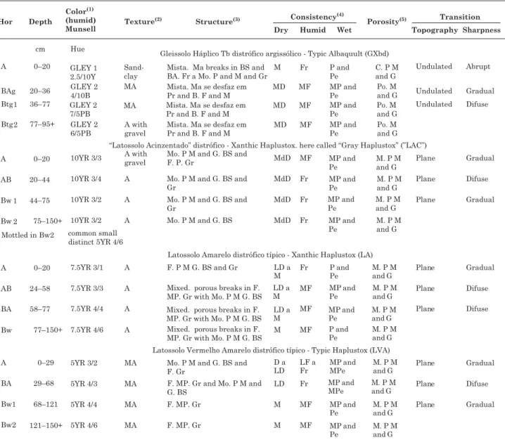
The wet color of GXbd is black or greyish, with greenish or bluish tones. The presence of Fe(II) nearly always results in a profile with bluish or greenish soil colors (Resende et al., 2007), which is evidence of hydromorphism (Breemen & Buurman, 2002). The structure is predominantly blocky, breaking down into prisms and medium to hard blocks. The texture across the profile is sandy-clayey in horizon A, very clayey in BAg and Btg1, and clayey with gravel in Btg2, representing a high B/A texture gradient. Porosity is low in most horizons (Table 1).
The wet color in horizons A and AB in the “LAC” is brownish. A wet greyish color is found in horizons Bw; it is mottled in Bw2. The texture is clayey in all horizons; weak to medium subangular block structures predominate in all horizons (Table 1).
Mottling in horizon Bw2 of the Lagoa do Leandro swamp shows the effects of the water table, which caused Fe reduction, migration, reoxidation, and accumulation in root pores and/or pores unconnected to the surface with trapped air (Breemen & Buurman, 2002). The mottled soil in Bw2 is not hardened as plinthite, and breaks down completely if immersed in
Figure 3. Lateral configuration of soil horizons on the slope of the Lagoa do Leandro swamp. Figure 2. Zones in the microbasin of the Lagoa do
water (Wood & Perkins, 1976; Daniels et al., 1978). The greyish colors of horizons Bw and mottling in horizons Bw2 in “LAC” are evidence of a predominantly hydric water regime, where pores were completely water-saturated in one or more formation stages (Resende et al., 2002).
The LA horizons are yellowish and the texture is predominantly clayey. A granular structure and subangular and medium granular blocks are common across the profile. The LVA is reddish and a very clayey texture predominates in the profile (Table 1).
Physical characterization
The horizon A of the GXbd is water-saturated in the rainy and desiccated in the dry season. This fluctuating water table results in ferrolysis (Brinkman, 1970; Breemen & Buurman, 2002; Ranst & Conick, 2002), which may have contributed to significant clay loss at its base, since the underlying horizon contains 230 % more clay (Table 2).
The sandy fraction is mostly fine sand, except in the LVA, in which coarse sand predominates (Table 2).
Table 1. Morphologic attributes of soils in the toposequence on the slope of the Lagoa do Leandro swamp
A high silt content in horizons A and BAg in the GXbd may have resulted from sediments transported from higher areas that would have reached the BAg horizon before horizon A was formed. A low silt content in the LVA (20 to 70 g kg-1) and a low silt/clay ratio (0.03 to 0.11) demonstrate the advanced weathering stage of this soil (Embrapa, 2006).
In the horizons BAg, Btg1 and Btg2 in the GXbd, the soil bulk density values were high, which may be the result of its massive structure. Poor soil packing/ The low soil density in the surface layer of the GXbd is associated with a higher OM content (Table 3). The bulk density in other soils was mostly around 1.00 gcm-3, which is typical of Latosols (Embrapa, 2006). Particle density was constant across the landscape except in horizon A of GXbd (Table 2), where the OM content was higher (Table 3). The solidity of soils affects particle density, for which OM and mineral admixture are the main contributing factors (Hillel, 1982).
The mean total pore volume is commonly 59.6 % in all Latosols (Embrapa, 2006; Ferreira et al., 2010). The total pore volume of the GXbd varied significantly according to bulk density (Table 2) and structure (Table 1).
Chemical characterization
These soils had low to very low organic matter contents, decreasing along the profile, except in
horizon A of GXbd, with medium contents (Table 3). Water table variations affect the decomposition rate of OM, ferrolysis, and soil leaching (van den Berg et al., 1987). Drainage conditions in the GXbd cause OM to accumulate, as anaerobiosis drastically minimizes the decomposing action of predominantly aerobic microorganisms (Breemen & Buurman, 2002). In the GXbd, the pH decreases with depth, parallel to a rise in Al content (Table 3). Increased acidity with depth is often observed in seasonally waterlogged soils (Brinkman, 1970). Soil Al and pH correlated negatively; as pH values increased, Al values decreased (Fageria et al., 1994). The pH increases, and Al and OM content decrease with depth in “LAC” and LA, which agrees with the data presented by Rodrigues & Klamt (1978) and Ferreira et al. (2010). Higher pH values in water compared to KCl values indicate that negative charges prevail in these soils, where profile mineralogy shows predominantly silicate clays.
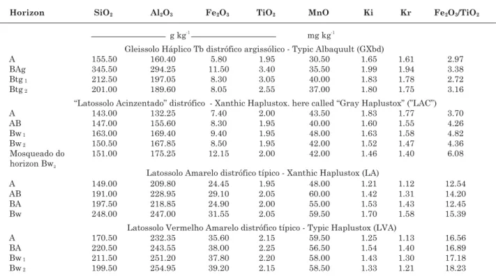
Phosphorus is strongly adsorbed in Latosols (Leal, 1971; Novais et al., 1991). Lower values of P occur mainly in subsurface horizons of La and LVA (Table 3), and may be due to specific adsorption of P on the surface of iron oxides in soils. The P content is higher in superficial horizons of Latosols, due to phosphate fertilizers applied to these areas of eucalyptus stands. These values decrease as the content of Fe2O3 (Table 4) and Fed (Table 5) increase
Table 2. Soil physical attributes in the toposequence on the slope of the Lagoa do Leandro swamp
Table 4. Total oxide content resulting from sulphuric attack, Ki and Kr indices, and the Fe2O3/TiO2 ratio of soils in the toposequence on the slope of the Lagoa do Leandro swamp
(1) Ki = [(% SiO
2 x 1.697)/%Al2O3]. (2) Kr = (%SiO2 x 1.697)/[(%Al2O3) + (%Fe2O3 x 0.64)].
Table 3. Soil chemical attributes in the toposequence on the slope of the Lagoa do Leandro swamp
in Latosols, and are proportionally much higher in “LAC”. According to Vahl (1999), P is adsorbed by iron oxides, which alter as this nutrient is released into the soil, as Fe is reduced and the mineral is dissolved.
The content of Ca and Mg in the GXbd increased, respectively, 3 and 2 - 4 times with depth. This was due to the diffusion rate of oxygen in soil layers and the activity of Fe-reducing microorganisms. Oxygen may be found in the first centimeters below the soil surface, in spite of the O2 diffusion rate being 10,000 times slower in water than in air (Ponnamperuma, 1972). Thus, seasonal water saturation in subsurface layers causes Ca and Mg to move from exchange sites, which increases their content deeper in the soil, especially if drainage is poor. In general, the K content in the toposequence is very low; relatively higher values may be found at the surface of Latosols, possibly because of eucalyptus fertilization (Table 3). Values of S and CEC decrease with depth, together with the content of OM, in profiles of “LAC”, LA and LVA, probably because of a continuous nutrient cycling process from deep to surface horizons in the roots of eucalyptus trees. This trend is inverted in the GXbd, as the content of Al, Ca, and Mg is higher in deeper, more water-saturated horizons; this indicates that the mineral structure of this soil may differ from that of Latosols (Tables 3 and 4).
The total content of Si oxides was lowest in the “LAC”, decreasing in the following sequence: LVA – LA – GXbd – “LAC”. The total content of Fe oxides decreased downslope in the following order: LVA – LA – “LAC”– GXbd (Table 4). The downslope decrease of the total Fe oxide content is related with poor past or present drainage (Breemen & Buurman, 2002; Ferreira et al., 2010). The total Ti oxide content ranged from 1.95 to 3.40 g kg-1, and was highest in the GXbd. These values were nearly 2.00 g kg-1 in Latosols. The total Mn oxide content ranged from 30.5 to 60.0 g kg-1, and also decreased downslope, probably due to poor drainage at some time during soil formation, in the following sequence: LVA – LA – “LAC”– GXbd (Table 4).
The Ki indices of the “LAC”, LA and LVA were relatively low (Table 4); thus, these profiles were included in the order of Latosols (Ki < 2.2). All soils in this study had Ki and Kr values above 0.75, suggesting a kaolin mineral mixture for the clay fraction (Embrapa, 2006).
The pH of soils in this study reduced the solubility of Al and Si; these elements are more concentrated on summits and back slopes (Bohn et al., 1985; Drees et al., 1989). As they undergo weak desilication, Si may recombine with Al, resulting in silicate clay minerals (Hsu, 1989).
Table 5. Iron, Al and Mn content originating from OAA and DCB extracts, and their relations with soils in the toposequence on the slope of the Lagoa do Leandro swamp
(1) Fe
The “LAC” had the lowest SiO2 values (Table 4), which was evidence of strong desilication in this soil; this is typical of ferralitic weathering (Rodrigues & Klamt, 1978; Breemen & Buurman, 2002).
The Fe2O3 content decreased with poorer drainage because of reduction processes in hydromorphic environments (Breemen & Buurman, 2002). The Fe2O3 content in the “LAC” is low, which is evidence of past reducing conditions, which remove Fe compounds. Current greyish colors (Table 1) and a low Fe2O3/TiO2 ratio in this soil type (Table 4) indicate hydromorphism in the past.
The Fe2O3/TiO2 ratio was used to check the effects of drainage on the color of Latosols; the values of this ratio are proportional to drainage conditions (Alleoni & Camargo, 1994), i.e., a higher ratio indicates better drainage. In this context, the LVA and the LA are the best-drained soils in this study; the Fe2O3/TiO2 ratio of these soils is four to six times higher than of GXbd, which in turn has similar values to those of the “LAC”. Because of its greyish color, the latter could be an ancient Gleysol (Paleogleysol) in which drainage improved because of lowering of the landscape and a strong action of the soil fauna on its structure (Table 4).
The contents of SiO2, Al2O3, TiO2, andMnO did not vary significantly in mottled “LAC” in the horizons (Bw2). The Fe2O3 content in mottled soils was about 50 % higher than in Bw2 (Table 4), which is evidence that Fe concentrates in occluded pores and is reoxidized (Coelho et al., 2001).
As with iron oxides, the content of MnO decreased along the slope (Table 4); iron and manganese ions have a similar chemical and geochemical behavior. Low MnO values may have resulted from reduction preceding that of Fe2O3 (Breemen & Buurman, 2002). The TiO2 content varied little in all profiles in this study, as they are hard to remove from soils (Oliveira et al., 1991).
The Feo content was higher in horizon A of the GXbd and the Yellow Latosol, and lower in the Btg horizon. The Feo content was higher in yellow and red-yellow soils (LA and LVA), where drainage is better, and lower in greyish soils (“LAC” and GXbd) (Table 5). The lowest Fed content values were found in the GXbd. The Bw1 horizon in the Red Yellow Latosol had the highest Fed and the Btg horizon the lowest content. In general, the Fed content decreased in the following sequence: : LVA – LA – “LAC” – GXbd. The Feo/Fed ratio decrease in the following order: GXbd – “LAC” – LA – LVA, which is evidence of increased crystallinity of Fe compounds upslope together with improved drainage (Schwertmann, 1985) (Table 5).
In general, all soils had a low Fed content, which was even lower in the GXbd and “LAC”; this is probably due to strong deferrification because of poor past or present drainage and poor parent material for this element. A reducing environment hinders
crystallization of iron oxides (Schwertmann, 1985), as seen in the Btg horizon of the GXbd (Table 5).
Generally speaking, the crystallinity grade of Fe increases with soil depth and decreases along the toposequence (Table 5), in agreement with findings of Ferreira et al. (2010).
The Feo/Fed ratio revealed a predominance of crystalline forms of Fe in LA and LVA, and lower crystallinity in the “LAC” and the GXbd – the Feo/ Fed ratio was higher than 0.07 (Torrent et al., 1980; Melo et al., 2001). The reason for a lower Feo/Fed ratio in the GXbd is Fe reduction, which decreases its crystallinity and increases the amount of less crystalline forms (Schwertmann, 1985).
The Alo content was higher in horizon A and lower in horizon Btg of the GXbd. The content of Alo was higher in horizon A in all profiles, possibly because of complexes being formed with humic substances (Breemen & Buurman, 2002). The Bw1 horizon in the “LAC” had the lowest Alo content among the Bw. The Ald content was higher in horizon A (high OM content) and lower in the Btg horizons of the GXbd (presence of a reducing environment) (Breemen & Buurman, 2002).
The Alo content in the subsurface diagnostic horizons of the toposequence studied decreased in the following order: LVA – LA - “LAC” – GXbd. The Ald content in the subsurface diagnostic horizons in soils of the toposequence decreased: LA – LVA - “LAC” – GXbd. The Alo/Ald ratio decreased in the order: GXbd – - “LAC” - LA – LVA (Table 5). In diagnostic horizons of the LA and the LVA, the Alo/Ald ratio indicated the predominance of crystalline Al forms (Alleoni & Camargo, 1994), whereas in the GXbd and the “LAC” high values of this ratio indicate the predominance of amorphous forms (Andrade et al., 1997).
The Feo/Fed and Alo/Ald ratios were similar across the landscape, which suggests that more crystalline forms of Fe and Al compounds occur in higher areas of the slope (Table 5).
The Mno content was higher in A horizons. Its content is similar in B horizons of soils in this toposequence; the lowest absolute value was found in Bw2 of the “LAC”. The Mnd content decreased downslope (Table 5).
Soil classification
(Figure 3). Based on the Soil Taxonomy (EUA, 1975), the same soil profiles were classified respectively as: Typic Haplustox (LVA), Xanthic Haplustox (LA), Xanthic Haplustox gray color, here called “Gray Haplustox” (“LAC”) and Typic Albaquult (GXbd).
CONCLUSIONS
1. The soils on the top and middle slope of the hillside investigated in this study have the typical morphological, physical, and chemical properties of Latosols.
2. The origin and properties of soils at the foot slope and base of swamps on the high plains of the upper Jequitinhonha valley are strongly affected by a water table that is superficial or close to the surface throughout the year, in the past and/or at present.
3. The total soil content of Fe, Feo, and Fed oxides in the study toposequence is related to the soil colors, and past and present drainage conditions.
ACKNOWLEDGEMENTS
The authors wish to thank the company ArcelorMittal S.A, the Brazilian Federal Agency for Support and Evaluation of Graduate Education (CAPES), and the Research Foundation of the state of Minas Gerais (FAPEMIG) for funding this study.
LITERATURE CITED
ALLEONI, L.R.F. & CAMARGO, O.A. Pontos de efeito salino nulo de Latossolos Ácricos. R. Bras. Ci. Solo, 18:175-180, 1994.
ANDRADE, H.; SCHAEFER, C.E.; DEMATTÊ, J.L.I. & ANDRADE, F.V. Pedogeomorfologia e micropedologia de uma sequência Latossolo – Areia Quartzoza Hidromórfica sobre rochas cristalinas do estado do Amazonas. Geonomos, 5:55-66, 1997.
BOAVENTURA, R.S. Contribuição ao estudo sobre a evolução das veredas. In: ENCONTRO NACIONAL DE GEÓGRAFOS, 3., 1978, Fortaleza. Anais... Fortaleza, AGB/UFC, 1978.
BOAVENTURA, R.S. Contribuição ao estudo sobre a evolução das veredas. In: PLANO DE DESENVOLVIMENTO INTEGRADO DO NOROESTE MINEIRO: RECURSOS NATURAIS, 2., Belo Horizonte, CETEC, 1981. (Apêndice A)
BOHN, H.L.; McNEAL, B.L. & O’CONNOR, G.A. Soil chemistry. New York, A Wiley-Interscience Publication, John Wiley & Sons, 1985. 341p.
BRASIL. Ministério do Planejamento e Orçamento. Fundação Instituto Brasileiro de Geografia e Estatística - IBGE. Diagnóstico ambiental da Bacia do Rio Jequitinhonha. Salvador, IBGE/Diretoria de Geociências, 1997. BREEMEN, N.V. & BUURMAN, P. Soil formation. 2.ed.
Dordrecht, Kluwer Academic, 2002. 404p.
BRINKMAN, R. Ferrolysis, a hydromorphic soil forming process. Geoderma, 3:199-206, 1970.
BOULET, R.; CHAUVEL, A.; HUMBEL, F.X. & LUCA, Y. Analyse structurale et cartographie em pédologie. Cahiers ORSTOM Séries Pédol., 19:309-351, 1982.
CARVALHO, P.G.S. As veredas e sua importância no domínio dos Cerrados. Inf. Agropec., 15:54-56, 1991.
COELHO, M.R.; VIDAL-TORRADO, P. & LADEIRA, F.S.B. Macro e micromorfologia de ferricretes nodulares desenvolvidos de Arenito do Grupo Bauru, Formação Adamantina. R. Bras. Ci. Solo, 25:371-385, 2001. DANIELS, R.B.; PERKINS, H.F.; HAJEK, B.F. & GAMBLE,
E.E. Morphology of discontinuous phase plinthite and criteria for its field identification in the Southeastern United States. Soil Sci. Soc. Am. J., 42:944-949, 1978. DREES, L.R.; WILDING, L.P.; SMECK, N.E. & SENKAYI,
A.L. Silica and soils: quartz and disordered silica polymorphs. In: DIXON, J.B. & WEED, S.B., eds. Minerals in soil environments. 2.ed. Madison, Soil Science Society of America, 1989. p.913-974.
DRUMMOND, G.M.; MARTINS, C.S.; MACHADO, A.B.M.; SEBAIO, F.A. & ANTONINI, Y. Biodiversidade em Minas Gerais: Um atlas para sua conservação. 2.ed. Belo Horizonte, Fundação Biodiversitas, 2005. 222p.
EMPRESA BRASILEIRA DE PESQUISA AGROPECUÁRIA – EMBRAPA. Centro Nacional de Pesquisa de Solos. Sistema brasileiro de classificação de solos. 2.ed. Rio de Janeiro, 2006. 306p.
EMPRESA BRASILEIRA DE PESQUISA AGROPECUÁRIA -EMBRAPA. Centro Nacional de Pesquisa de Solos. Manual de métodos de análise de solo. 2.ed. Rio de Janeiro, 1997. 212p.
ESTADOS UNIDOS. Department of Agriculture. Soil Survey Division. Soil Conservation Service. Soil Survey Staff. Soil taxonomy: A basic system of soil classification for making and interpreting soil surveys. Washington, 1975. 754p. (USDA. Agriculture Handbook, 436).
FAGERIA, N.K.; FILHO, M.P.B. & ZIMMERMANN, F.J.P. Caracterização química e granulométrica de solos de várzea de alguns estados brasileiros. Pesq. Agropec. Bras., 29:267-274, 1994.
FERREIRA, C.A.; SILVA, A.C.; VIDAL TORRADO, P. & ROCHA, W.W. Genesis and classification of Oxisols in a highland toposequence of the Alto Vale do Jequitinhonha (MG). R. Bras. Ci. Solo, 34:195-209, 2010.
HSU, P.H. Aluminium oxides and oxyhydroxides. In: DIXON, J.B. & WEED, S.B., eds. Minerals in soil environments. 2.ed. Madison, Soil Science Society of America, 1989. p.331-378.
LEAL, J.R. Adsorção de fósforo em Latossolos sob cerrado. Itaguaí, Universidade Federal Rural do Rio de Janeiro, 1971. 96p. (Tese de Mestrado)
LIMA, S.C. & QUEIROZ NETO, J.P. As veredas e a evolução do relevo. Soc. Natur., 8:481-488, 1996.
MELO, D.R. As veredas nos planaltos do Noroeste Mineiro: Caracterizações pedológicas e os aspectos morfológicos e evolutivos. Rio Claro, Universidade Estadual de São Paulo, 1992. 218p. (Tese de Mestrado)
MELO, D.R. Contribuição ao estudo geomorfológico de veredas: Região de Pirapora, MG. Belo Horizonte, Universidade Federal de Minas Gerais, 1978. 48p. (Graduação em Geografia)
MELO, V.F.; FONTES, N.P.F.; NOVAIS, R.F.; SINGH, B. & SCHAEFER, C.E.G.R. Características dos óxidos de ferro e alumínio de diferentes classes de solos. R. Bras. Ci. Solo, 25:19-32, 2001.
McKEAGUE, J.A. & DAY, J.H. Dithionite and oxalate extractable Fe and Al as aids in differentiating various classes of soils. Canadian J. Soil. Sci., 46:13-22, 1966. MEHRA, O.P. & JACKSON, M.L. Iron oxide removal from
soils and clay by a dithionite-citrate system buffered with sodium bicarbonate. Clays Clay Miner., 7:317-327, 1960. NOVAIS, R.F.; NEVES, J.C.L. & BARROS, N.F. Aspectos físicos-quimicos envolvidos na fixação de fósforo no solo. In: ENCONTRO NACIONAL DE ROCHA FOSFÁTICA, 5., São Paulo, 1991. Anais... São Paulo, 1991. p.133-177. OLIVEIRA, J.B.; RESENDE, M. & CURI, N. Caracterização e
classificação de Latossolos variação uma e de solos afins da região de Guaíra, SP. R. Bras. Ci. Solo, 15:207-218, 1991.
PONNAMPERUMA, F.N. The chemistry of submerged soil. Adv. Agron., 24:29-96, 1972.
PROJETO RADAMMINAS. Geomorfologia: Mapa geomorfológico - Folha Montes Claros Escala de 1:500.000. Belo Horizonte, 1977.
RANST, E.V. & CONINCK, F. Evaluation of ferrolysis in soil formation. Laboratory of Soil Science, Ghent University. Europ. J. Soil. Sci., p.513-519, 2002.
RESENDE, M.; CURI, N.; REZENDE, S.B. & CORRÊA, G.F. Pedologia: Base para distinção de ambientes. 5.ed. Lavras, Universidade Federal de Lavras, 2007.
RESENDE, M.; CURI, N.; REZENDE, S.B. & CORRÊA, G.F. Pedologia: Base para distinção de ambientes. 4.ed. Viçosa, MG, NEPTU, 2002. 332p.
RODRIGUES, T.E. & KLAMT, E. Mineralogia e gênese de uma sequência de solos do Distrito Federal. R. Bras. Ci. Solo, 2:132-139, 1978.
SANTOS, R.D.; LEMOS, R.C.; SANTOS, H.G.; KER, J.C. & ANJOS, L.H. Manual de descrição e coleta de solos no campo. 5.ed. Viçosa, MG, Sociedade Brasileira de Ciência do Solo, 2005. 100p.
SCHWERTMANN, U. Use of oxalate for Fe extraction from soil. Canadian J. Soil. Sci., 53:244-248, 1973.
SCHWERTMANN, U. Occurrence and formation of iron oxides in varius pedo environments. In: STUCKI, J.W.; GOODMAN, B.A. & SCHWERTMANN, U., eds. IRON IN SOILS AND CLAY MINERALS; A NATO ADVANCED STUDY INSTITUTE ON IRON IN SOILS AND CLAY MINERALS, 1985. Proceeding… Bad Windsheim, 1985. p.758-810.
TORRENT, J.; SCHWERTMANN, U. & SCHULZE, D.J. Iron oxide mineralogy of some two river terrace sequences in Spain. Geoderma, 23:191-208, 1980.
VAHL, L.C. Fertilidade de solos de várzea. In: GOMES, A.S. & PAULETTO, E.A., eds. Manejo de solo e da água em areas de várzea. Pelotas, Embrapa Clima Temperado, 1999. p.119-162.
van den BERG, M.; LESPCH, I.F. & SAKAI, E. Solos de planícies aluviais do Vale do Ribeira do Iguapé SP. II. Relações entre características físicas e químicas. R. Bras. Ci. Solo, 11:315-321, 1987.