REPRESENTATIVE OF THE BRAZILIAN COASTAL
PLAINS AND ITS PRACTICAL APPLICATION
Levantamento detalhado de solos de uma microbacia hidrográfica experimental representativa dos Tabuleiros Costeiros brasileiros e sua aplicação prática
Walbert Júnior Reis dos Santos1, Nilton Curi2, Sérgio Henrique Godinho Silva2, Sebastião da Fonseca3, Elidiane da Silva2, João José Marques2
ABSTRACT
This paper presents a detailed soil survey of an experimental watershed with representative pedoclimatic characteristics of the Coastal Plains in Espírito Santo State and its practical applications. For the pedological survey, 35 observation sites and three
soil profiles were sampled and described, which were morphologically characterized and subjected to physical (particle size) and chemical analyses (routine and sulfuric acid digestion). The soil map was made using the geographic information system ArcGIS 9.3. This GIS software was also used to generate the digital elevation model (DEM) for identifying the slope classes. SAGA software was used to calculate the topographic wetness index (WI) which aided in a more accurate separation of Haplic Organosol from other soils. The predominant soil class in the watershed was the dystrophic/dystrocohesive Yellow Argisol (97%), containing morphological, chemical and physical characteristics representative of the most expressive Coastal Plains soils. Geoprocessing tools
and techniques aided to make the watershed soil map.
Index terms: Soil map, geoprocessing, GIS.
RESUMO
Neste trabalho, apresenta-se o levantamento detalhado de uma microbacia hidrográfica experimental representativa das
características pedoclimáticas dos Tabuleiros Costeiros brasileiros e sua aplicação prática. Para o levantamento pedológico, foram
descritos morfologicamente e amostradas 35 microtrincheiras e três perfis modais, cujas amostras foram submetidas a análises físicas (textura) e químicas (fertilidade e ataque sulfúrico). A confecção do mapa de solos foi realizada, utilizando-se o sistema de informação geográfica ArcGIS 9.3, no qual foi gerado o modelo digital de elevação (DEM) para a separação das fases de relevo. Utilizou-se também o programa SAGA GIS, para a geração do índice topográfico de umidade (WI) que auxiliou na separação mais precisa do Organossolo Háplico dos demais solos. A classe de solo predominante na microbacia foi o Argissolo Amarelo distrófico/ distrocoeso (97%), com características morfológicas, químicas e físicas representativas dos solos mais expressivos dos Tabuleiros Costeiros. Ferramentas e técnicas de geoprocessamento auxiliaram na confecção do mapa de solos da microbacia.
Termos para indexação: Mapa de solos, geoprocessamento, SIG.
1Companhia de Desenvolvimento dos Vales do São Francisco e Parnaíba/CODEVASF – 1ª SR – Avenida Geraldo Athayde – n. 483 – Alto São João –
Montes Claros – MG – Brasil – [email protected]
2Universidade Federal de Lavras/UFLA – Departamento de Ciência do Solo – Lavras – MG – Brasil 3Fibria Celulose S/A – Barra do Riacho – ES – Brasil
Received in november 7, 2013 and approved in january 10, 2014 INTRODUCTION
Soil survey constitutes one of the first stages of
the physiographical and geomorphological study of a watershed, being the basis for several types of work,
as can be seen in Costa et al. (2009a), Menezes et al. (2009) and Tonello et al. (2006), not only because soil is
considered the main natural resource for land use planning, but also because soil classes stand out as an appropriate
environmental stratifier at a local level (Curi, 2000). However, Brazil lacks detailed soil surveys (McBratney; Mendonça-Santos; Minasny, 2003), once the existent ones commonly present scales smaller than 1:250,000.
For planning of areas that require a higher level of detail,
such as watersheds, map scales at 1:50,000 or greater are necessary (Menezes et al., 2009). In that sense, the use of geotechnologies such as GPS, digital maps, digital elevation models (DEM) and geographical information systems (GIS), along with modern geoprocessing
techniques and tools, aid the production of greater scale soil maps, facilitating a more precise delimitation of the
soil classes (McBratney; Mendonça-Santos; Minasny, 2003; Costa et al., 2009b; Horta et al., 2009).
Watersheds constitute a fundamental unit of work,
pedo-hydrologically monitored (Cardoso et al., 2006). The
watershed under this study is an experimental area whose
purpose is to host various scientific research activities. It is
located in the Coastal Plains, which present an estimated
area about 20 million hectares. As an indicative of the importance of that environment, it contains about 50% of the population of the Brazilian Northeast region (Moreau et al., 2006).
The soils of the Coastal Plains originated from
pre-weathered sediments of the Barreiras Formation and
their main land uses are sugarcane, livestock, silviculture,
and orchards (Souza et al., 2004; Fonsêca et al., 2007; Costa et al., 2009c). The dominant soil class is Yellow Argisol (Carvalho Filho; Curi; Fonseca, 2013), presenting
chemical and physical properties somewhat restrictive to management. Chemically, the restriction is caused by the low cation exchange capacity and nutrient contents, due to
the essentially kaolinitic nature of the Barreiras Formation
sediments and the weathering-leaching processes, while the physical restrictions are related to the low permeability
and cohesive subsurface horizons that prevent plant root
deepening, thus limiting water and nutrient absorption by
the roots (Fonsêca et al., 2007), as a natural consequence
of reducing the effective soil depth explored by the root
system. However, these constraints can be minimized
through management practices, mainly for perennial crops,
such as the use of fertilizers and subsoilers to overcome the
chemical and physical constraints, respectively. The great challenge is the management of annual crops because the Coastal Plains soils are strongly affected by frequent soil revolving, which leads to degradation of the surface soil
horizon, with intense rate of sheet erosion, even when they occur on gentle slopes (Resende; Curi; Santana, 1988).
Based on the mentioned above, the objectives of
the present work were to conduct a detailed soil survey
(scale 1:10,000) of an experimental watershed using geoprocessing techniques to complement the field work
and its practical application.
MATERIAL AND METHODS
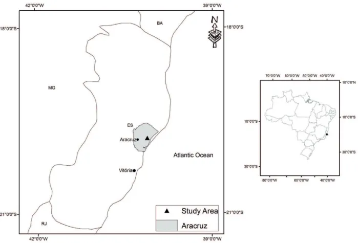
The work was carried out in an experimental hydrographic watershed, property of Fibria Celulose S.A.,
in Aracruz county, Espírito Santo State, central coordinates 40o06’34” WGr and 19o 47’41” S, with 181.7 ha (Figure
1). The climate is Aw (tropical climate with a dry season in winter), according to the Köppen classification. The average annual temperature is 23o C, with precipitation of
1,400 mm year-1. The geology comprises sediments of the
Barreiras Formation (Duarte et al., 2000). The predominant
native vegetation is represented by semiperennial tropical
forest. However, most of the watershed has been planted with eucalyptus (135 ha).
In the field work, a planialtimetric survey of the watershed at a 1:2,500 scale was used as base-map, with
vertical distance among contour lines equals to 1 m. Prospections throughout the area were carried out using
the free walking method, being 22 prospections (small trenches) in the area under eucalyptus cultivation and 13
prospections in the preservation area, with a sampling
density of 0.19 prospections ha-1. For the small trenches, a
40 x 40 x 40 cm pit was dug for observation and description of the A horizon and surficial samples collection. For deeper observations and collections, up to 1.20 m, a Dutch auger was employed. All of the prospections were georeferenced with a GPS. Samples were collected, at depths from 0 to 20 cm, 40 to 70 cm and 100 to 120 cm for chemical and physical analyses (Empresa Brasileira de Pesquisa Agropecuária - Embrapa, 1997) to support field physical and chemical characterizations, as well as
for soil mapping.
After the morphological description and collection
of samples, areas were chosen to represent the variability
of the soils to be described as modal profiles (deep trenches), where morphological descriptions and soil
sample collections were conducted according to Lemos et
al. (2013), being the soils classified according to Embrapa (2013). In the modal profiles, besides the soil physical and chemical characterizations, the quantification of Si, Al, Fe, Ti and P was determined in the fine air-dried soil fraction after sulfuric acid digestion, according to Embrapa (1997).
For definition of the soil mapping units (MUs),
drainage, textural gradient, mottling, gravels, rockiness, among other soil attributes were considered as main features.
To prepare the soil map, the ArcGIS 9.3 software (ESRI) was used. First, the digital elevation model (DEM)
was created through the topo-to-raster function, using the
elevation of the contour lines. Starting from the DEM, the topographical wetness index (WI) was generated in the SAGA GIS 2.0.7 software, which aided the more precise separation of Haplic Organosol from the other soils, because WI reflects the tendency of the water to
accumulate in some point of the drainage basin. For the
definition of the other MUs limits, eucalyptus plantation was separated from the preservation area (steeper relief).
For each of these two conditions, a raster of probability was created to identify the places more likely to represent
Then, the two rasters of probability of the MUs were superimposed, using the highest position tool of ArcGIS, and, for each specific place, the raster that presented highest probability would be classified according to its corresponding MU, thus delimiting the MUs boundaries. After these procedures, DEM was used to define the following slope classes: plain (0-3%), gently undulated (3-8%), undulated (8-20%) and strongly undulated (20-45%), that were cross-referenced with the MUs. Small adjustments were manually made through the advanced editing tool of ArcGIS.
RESULTS AND DISCUSSION
Detailed soil survey
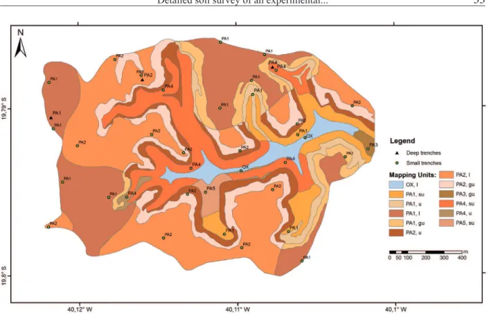
Figure 2 and table 1 present the soil map and the geographical expression of MUs, respectively, for further information and complete descriptions of the profiles,
additionally to the analytical results of the small trenches,
consult Santos (2012). It can be seen that 96.4% of the
watershed soils belong to the distrophic/distrocohesive
Yellow Argisol class and, according to Carvalho Filho; Curi; Fonseca (2013), the main soils of the Brazilian Coastal Plains are Yellow Argisols. The MUs chosen for having a soil pit dug and a modal profile described were PA1, PA2 and PA4. These three MUs count for approximately 95% of the watershed area (Table 1). The complete classification of the modal profiles is presented in table 2.
Only 3.6% of the soils of the watershed do not belong to the Yellow Argisol class (PA), being them classified as Haplic Organosol (OX), whose formation is related to environments subject to waterlogging and organic matter accumulation (Resende et al., 2007).
This fact is confirmed by their occurrence in the low elevation parts of the watershed, where the highest
values of the topographical wetness index (WI) are concentrated. The WI value used to separate OX from other MUs was 15, a value consistent with field
observations.
Figure 2 – Soil map of the experimental watershed in the Coastal Plains of Espírito Santo State. OX - Haplic Organosol; PA1 - Well-drained typic dystrophic/distrocohesive Yellow Argisol; PA2 – Moderately drained typic dystrophic/
dystrocohesive Yellow Argisol; PA3 – Imperfectly drained typic dystrophic Yellow Argisol; PA4 - Well-drainedrocky
typic dystrocohesive Yellow Argisol; PA5 - Well-drained moderately rocky typic dystrophic Yellow Argisol; l - level; gu – gently undulated; u - undulated; su- strongly undulated.
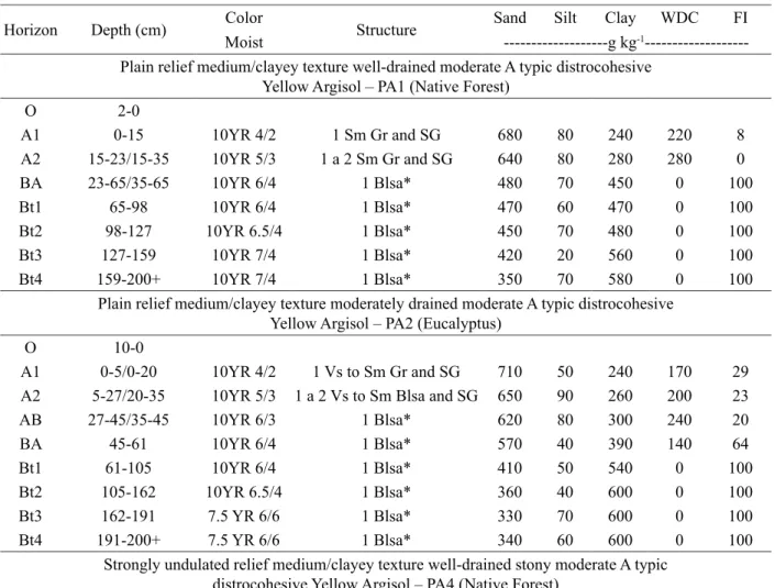
Morphological and physical characteristics of the soils
Table 3 presents the summarized morphological and physical characteristics of the modal profiles.
The soils present predominantly yellowish colors
in the hues 10YR and 7.5YR, which are due to the low
Fe2O3 content (Duarte et al., 2000; Moreau et al., 2006),
indicating extremely kaolinitic mineralogy (Ferreira et al., 1999). In the modal profile 2, mottling increases at depth, going from common to abundant, and in the Bt3 and Bt4 horizons the soil matrix becomes 7.5YR (somewhat redder than 10YR of the above horizons). It possibly happens
because the current pedogenetic environment allows the maintenance of inherited kaolinite and at the same time promotes goethite formation, dissolving and removing
hematite from the surface horizons. These processes favor the yellowing at the top of those soils (Duarte et al., 2000).
The structure is predominantly subangular blocky
in the Bt horizon with a weak degree of development
(cohesive massive aspect in situ), peculiar characteristic
of Argisols and Latosols developed from sediments of the Barreiras Formation (Corrêa et al., 2008a), as are those ones of the present study. The BA and Bt horizons
presented cohesive massive aspect in situ in all of the
modal profiles. The origin of the cohesive horizons in the Brazilian Coastal Plains is still controversial (Giarola et al., 2009), being associated with multiple, interrelated factors (Corrêa et al., 2008a; Giarola et al., 2009; Lima Neto et al., 2009; Vieira et al., 2012). According to some authors,
the wide prevalence of large kaolinite crystals in the clay fraction of these soils can contribute to their cohesion, because the laminar shape of the kaolinite particles enables
a face-to-face fit in the horizons with lower organic matter and Fe and Al oxides content (Lima et al., 2005; Resende et al., 2007; Martins et al., 2011; Resende et al., 2011). On the other hand, other authors have demonstrated that the illuviated fine clay content in these horizons can be a
(Corrêa et al., 2008a; Giarola et al., 2009; Lima Neto et al., 2010). However, in the analyzed modal profiles, clay skins, indicators of clay illuviation (Resende et al., 2007), were not observed during the field work.
(Santana et al., 2006; Lima Neto et al., 2009), thickening and growing parallel to it (Carvalho Filho; Curi; Fonseca, 2013). Portela et al. (2001) pointed out that, although the
soils of the Coastal Plains are deep, they present a few
roots in depth due to the presence of cohesive horizons,
particularly in areas with pronounced dry season.
In all of the modal profiles (Table 3) and observed small trenches, excluding OX, there was an increase
in the clay content at depth, ranging from medium to clayey texture. Such clay increment at depth was enough
to classify the soils as Argisols (Embrapa, 2013). The occurrence of textural gradients in the Argisols from the
Coastal Plains is mainly due to the preferential removal
of finer particles from the upper horizons (Universidade Federal De Viçosa - UFV, 1984). Furthermore, a clay
destruction process can occur along with that removal, increasing even more the textural differentiation of the
horizons (Corrêa et al., 2008a).
The studied profiles presented low silt content and
low silt/clay ratio. The low silt/clay ratio of the Coastal Plains soils occurs because such soils originate from
pre-weathered sediments. In that sense, the low silt/clay ratio is characteristic of Barreiras Formation sediments and does not well express the genetic maturity of the soil (Moreau et al., 2006). The highest silt/clay ratios occurred in the surface horizons (A, AB, and BA), and they are probably due to the relative loss of clay in the surface (Silva et al., 2002) and/or dispersion problems in the laboratory.
The clay content dispersed in water is higher in the
upper horizons, in accordance to the higher organic matter content. The deeper horizons present 100% of the clay flocculated, a behavior that was also observed by Moreau et al. (2006) and Silva; Carvalho (2007).
Fertility characteristics of the soils
Results of the fertility analyses for modal soil profiles are presented in table 4. Both in the modal profiles
and in most of the small trenches the results presented low
nutrient availability with high Al saturation, low sum of
Table 1 – Geographical expressionof the soil mapping unitsof a pilotwatershedin the Coastal PlainsofEspírito Santo.
Mus Area (ha) Area (%)
OX, level 6.6 3.6%
PA1, level 37.6 20.7%
PA1, gently undulated 9.5 5.2%
PA1, undulated 7.4 4.1%
PA1, strongly undulated 11.9 6.6%
PA2, level 48.3 26.6%
PA2, gently undulated 18.9 10.4%
PA2, undulated 14.9 8.2%
PA3, gently undulated 0.9 0.5%
PA4, undulated 1.1 0.6%
PA4, strongly undulated 22.2 12.2%
PA5, undulated 2.3 1.3%
Total 181.7 100.0%
MUs - Soil mapping units, OX - Haplic Organosol; PA1 - Well-drained typic dystrophic/distrocohesive Yellow Argisol; PA2 – Moderately drained typic dystrophic/dystrocohesive Yellow Argisol; PA3 – Imperfectly drained typic dystrophic Yellow Argisol; PA4 - Well-drainedrocky typic dystrocohesive Yellow
Argisol; PA5 - Well-drained moderately rocky typic dystrophic Yellow Argisol.
Table 2 – Complete classification of the modal soil profiles of the experimental watershed in the Coastal Plains of
Espírito Santo State.
Modal Profile Classification
Profile1 Plain relief medium/clayey texture well-drained moderate A typic distrocohesive Yellow Argisol
Profile2 Plain relief medium/clayey texture moderately drained moderate A typic distrocohesive Yellow Argisol
Profile3 Strongly undulated relief medium/clayey texture well drained stony moderate A typic distrocohesive
Yellow Argisol MUs – Maping units.
The plant roots in the cohesive horizons varied
from few to rare. The high penetration resistance of those
horizons, specially when dry, prevents root growth in
Table 3 – Morphological and physical characteristics of modal soil profiles of experimental watershed in the Coastal
Plains of Espírito Santo.
Horizon Depth (cm) Color Structure Sand Silt Clay WDC FI
Moist ---g kg-1
---Plain relief medium/clayey texture well-drained moderate A typic distrocohesive Yellow Argisol – PA1 (Native Forest)
O 2-0
A1 0-15 10YR 4/2 1 Sm Gr and SG 680 80 240 220 8
A2 15-23/15-35 10YR 5/3 1 a 2 Sm Gr and SG 640 80 280 280 0
BA 23-65/35-65 10YR 6/4 1 Blsa* 480 70 450 0 100
Bt1 65-98 10YR 6/4 1 Blsa* 470 60 470 0 100
Bt2 98-127 10YR 6.5/4 1 Blsa* 450 70 480 0 100
Bt3 127-159 10YR 7/4 1 Blsa* 420 20 560 0 100
Bt4 159-200+ 10YR 7/4 1 Blsa* 350 70 580 0 100
Plain relief medium/clayey texture moderately drained moderate A typic distrocohesive Yellow Argisol – PA2 (Eucalyptus)
O 10-0
A1 0-5/0-20 10YR 4/2 1 Vs to Sm Gr and SG 710 50 240 170 29
A2 5-27/20-35 10YR 5/3 1 a 2 Vs to Sm Blsa and SG 650 90 260 200 23
AB 27-45/35-45 10YR 6/3 1 Blsa* 620 80 300 240 20
BA 45-61 10YR 6/4 1 Blsa* 570 40 390 140 64
Bt1 61-105 10YR 6/4 1 Blsa* 410 50 540 0 100
Bt2 105-162 10YR 6.5/4 1 Blsa* 360 40 600 0 100
Bt3 162-191 7.5 YR 6/6 1 Blsa* 330 70 600 0 100
Bt4 191-200+ 7.5 YR 6/6 1 Blsa* 340 60 600 0 100
Strongly undulated relief medium/clayey texture well-drained stony moderate A typic distrocohesive Yellow Argisol – PA4 (Native Forest)
O 8-0
A 0-13 10 YR 4/2 1 M to Sm Gr and SG 640 60 300 220 27
AB 13-43 10YR 5/3 1 to 2 Blsa and Gr 620 70 310 240 22
BA 43-61 10YR 6/6 1 Blsa* 430 80 490 340 31
Bt1 61-85 10YR 5/6 1 Blsa* 380 40 580 0 100
Bt2 85-193 9YR 6/6 1 Blsa* 380 50 570 0 100
BC 193-225 7.5YR 5/6 1 Blsa* 420 70 510 0 100
C 225-251/225-316 7.5YR 7/4 1 Blsa* 310 130 560 0 100
Cx 251-329+/316-329+ Variegated 1 Blsa* 490 80 430 0 100
Structure: 1 - Weak; 2 - Moderate; Blsa* - Subangular blocks with cohesive massive aspect in situ; Vs – Very Small; Sm - Small; M -
Medium; Gr - Granular; SG – Single Grains; Blsa - Subangular blocks. WDC – Water-dispersible clay and FI - Flocculation index .
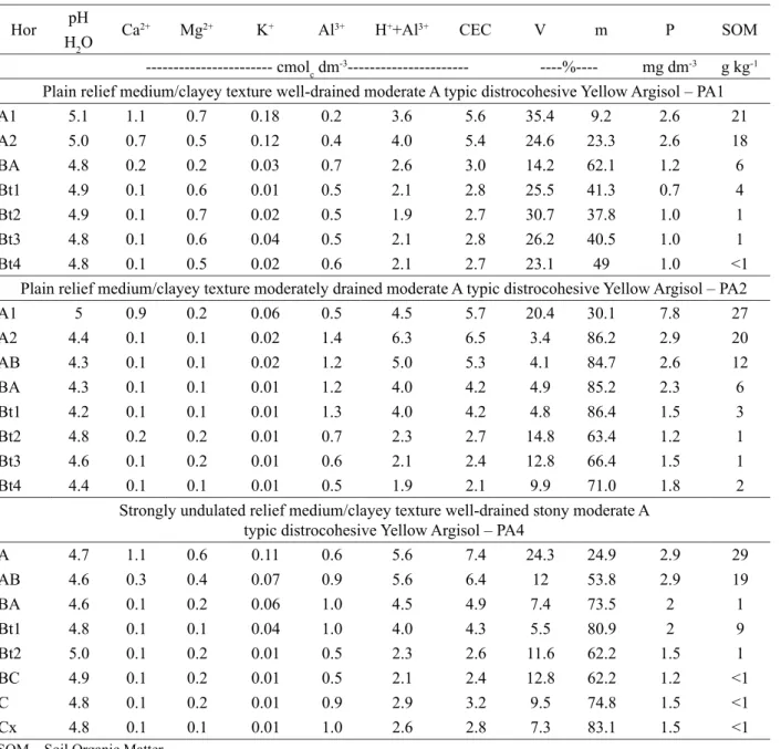
bases, low bases saturation, acidic pH, low available P and low cation exchange capacity (CEC). The low CEC values, smaller than 8 cmolc kg
-1, reflect the kaolinitic mineralogy
of the clay fraction. These results were similar to others
et al., 2009; Lima Neto et al., 2009). The chemical poverty of the Brazilian Coastal Plains soils is the result of a highly (pre)weathered parent material (Lima Neto et al., 2009),
in addition to the loss of nutrients during transport and deposition of sediments.
It was observed that approximately 20% of the area planted with eucalyptus presented epieutrofism (V > 50% at the surface), where Ca and Mg predominated
as the major components of sum of bases, and low Al saturation in surface. This is due to enrichment by
applications of fertilizers and correctives during soil preparation for eucalyptus plantation. According to Resende; Curi and Santana (1988), plain relief and low water infiltration rate make this pedoenvironment
conservative of nutrients, although with low natural fertility.
Table 4 – Results of fertility analyses of modal soil profiles in an experimental watershed in the Coastal Plains of
Espírito Santo State.
Hor pH Ca2+ Mg2+ K+ Al3+ H++Al3+ CEC V m P SOM
H2O
--- cmolc dm-3--- ----%---- mg dm-3 g kg-1 Plain relief medium/clayey texture well-drained moderate A typic distrocohesive Yellow Argisol – PA1
A1 5.1 1.1 0.7 0.18 0.2 3.6 5.6 35.4 9.2 2.6 21
A2 5.0 0.7 0.5 0.12 0.4 4.0 5.4 24.6 23.3 2.6 18
BA 4.8 0.2 0.2 0.03 0.7 2.6 3.0 14.2 62.1 1.2 6
Bt1 4.9 0.1 0.6 0.01 0.5 2.1 2.8 25.5 41.3 0.7 4
Bt2 4.9 0.1 0.7 0.02 0.5 1.9 2.7 30.7 37.8 1.0 1
Bt3 4.8 0.1 0.6 0.04 0.5 2.1 2.8 26.2 40.5 1.0 1
Bt4 4.8 0.1 0.5 0.02 0.6 2.1 2.7 23.1 49 1.0 <1
Plain relief medium/clayey texture moderately drained moderate A typic distrocohesive Yellow Argisol – PA2
A1 5 0.9 0.2 0.06 0.5 4.5 5.7 20.4 30.1 7.8 27
A2 4.4 0.1 0.1 0.02 1.4 6.3 6.5 3.4 86.2 2.9 20
AB 4.3 0.1 0.1 0.02 1.2 5.0 5.3 4.1 84.7 2.6 12
BA 4.3 0.1 0.1 0.01 1.2 4.0 4.2 4.9 85.2 2.3 6
Bt1 4.2 0.1 0.1 0.01 1.3 4.0 4.2 4.8 86.4 1.5 3
Bt2 4.8 0.2 0.2 0.01 0.7 2.3 2.7 14.8 63.4 1.2 1
Bt3 4.6 0.1 0.2 0.01 0.6 2.1 2.4 12.8 66.4 1.5 1
Bt4 4.4 0.1 0.1 0.01 0.5 1.9 2.1 9.9 71.0 1.8 2
Strongly undulated relief medium/clayey texture well-drained stony moderate A typic distrocohesive Yellow Argisol – PA4
A 4.7 1.1 0.6 0.11 0.6 5.6 7.4 24.3 24.9 2.9 29
AB 4.6 0.3 0.4 0.07 0.9 5.6 6.4 12 53.8 2.9 19
BA 4.6 0.1 0.2 0.06 1.0 4.5 4.9 7.4 73.5 2 1
Bt1 4.8 0.1 0.1 0.04 1.0 4.0 4.3 5.5 80.9 2 9
Bt2 5.0 0.1 0.2 0.01 0.5 2.3 2.6 11.6 62.2 1.5 1
BC 4.9 0.1 0.2 0.01 0.5 2.1 2.4 12.8 62.2 1.2 <1 C 4.8 0.1 0.2 0.01 0.9 2.9 3.2 9.5 74.8 1.5 <1 Cx 4.8 0.1 0.1 0.01 1.0 2.6 2.8 7.3 83.1 1.5 <1
Sulfuric acid digestion
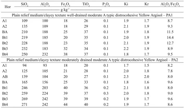
Table 5 presents the results of the sulfuric acid
digestion of the modal soil profiles samples. Low Fe2O3
content (< 80 g kg-1) is observed in all of the samples, a
striking characteristic of the Coastal Plains soils (Corrêa et al., 2008b; Duarte et al., 2000; Lima et al., 2004) that reflects the low Fe content of the parent material of
these soils and the loss of this element during transport and deposition of sediments, framing them as hipoferric
(Embrapa, 2013). It is noticed that the Fe2O3 content tends
to increase at depth, as well as the clay content (Table 3).
That is probably a result of clay selective loss in the upper
horizons (UFV, 1984).
In the Coastal Plains soils, goethite is the dominant Fe oxide, being common the absence of hematite. Hematite can be found in deep B horizons, where the current pedogenetic
conditions, which are unfavorable for its maintenance in the system, have not acted enough for completing its total
dissolution (Duarte et al., 2000). This trend can be observed by less yellow hues of deeper B horizons of PA2 and PA4 modal profiles, respectively 7.5YR and 9YR. This reddening commonly occurs more in the C horizon, here achieved only in the description of the profile PA4 (7.5 YR color).
Table 5 – Results of sulfuric acid digestion and Ki, Kr and Al2O3/ Fe2O3 ratios of the modal profile horizons.
Hor SiO2 Al2O3 Fe2O3 TiO2 P2O5 Ki Kr Al2O3/Fe2O3
--- g kg-1
---Plain relief medium/clayey texture well-drained moderate A typic distrocohesive Yellow Argisol – PA1
A1 109 100 18 26 0.1 1.9 1.7 8.7
A2 135 109 18 29 0.1 2.1 1.9 9.3
BA 210 188 25 37 0.1 1.9 1.8 11.5
Bt1 219 185 20 35 0.1 2.0 1.9 14.4
Bt2 228 188 23 35 0.1 2.1 1.9 12.7
Bt3 232 183 32 34 0.1 2.2 1.9 8.9
Bt4 250 232 38 37 0.1 1.8 1.7 9.5
Plain relief medium/clayey texture moderately drained moderate A typic distrocohesive Yellow Argisol – PA2
A1 94 93 18 20 0.1 1.7 1.5 8.2
A2 125 105 21 28 0.1 2.0 1.8 7.8
AB 139 104 20 27 0.1 2.3 2.0 8.0
BA 165 156 25 33 0.1 1.8 1.6 9.6
Bt1 246 203 40 36 0.2 2.1 1.8 8.0
Bt2 259 224 39 37 0.3 2.0 1.8 9.0
Bt3 269 242 39 39 0.2 1.9 1.7 9.6
Bt4 271 242 44 40 0.2 1.9 1.7 8.6
Strongly undulated relief medium/clayey texture well-drained stony moderate A typic distrocohesive Yellow Argisol – PA4
A 129 120 38 30 0.2 1.8 1.5 5.0
AB 168 147 45 36 0.2 2.0 1.6 4.9
BA 199 146 56 39 0.2 2.3 1.9 4.1
Bt1 245 216 67 39 0.2 1.9 1.6 5.1
Bt2 221 207 71 37 0.2 1.8 1.5 4.6
BC 220 205 59 35 0.4 1.8 1.6 5.5
C 294 271 79 44 0.5 1.8 1.6 5.2
The Ki index of all modal profiles reflects the kaolinitic nature of the clay fraction (EMBRAPA, 2013).
That fact indicates a relatively advanced weathering stage, a result consistent with several other studies
(Lima et al., 2004; Moreau et al., 2006; Lima Neto et al., 2009).
Practical applications
Considering that the soils of the Brazilian
Coastal Plains are not suitable for annual crops, mainly for large areas, eucalyptus is a viable choice
(Carvalho Filho; Curi; Fonseca, 2013) and this option
is in accordance to the destination of this watershed.
Beyond eucalyptus, other forest species, pastures,
perennial and semiperennial crops, such as sugar cane, can be potentially used because they promote little soil
disturbance. Thus, the major vocation of the Coastal
Plains soils is closely related to production of crops with low rate of soil disturbance.
As the soil classification, the morphology,
physical and chemical properties of the soils of this watershed are in agreement with the main soils of the
Brazilian Coastal Plains, it is worthy to consider that this
experimental watershed is highly representative of that environment. Then, the various researches developed there will have a secure and ample geographical
representation and therefore justify the choice and
the future investments applied in this experimental watershed.
CONCLUSIONS
The most widely predominant soil class in the experimental watershed is the dystrophic/dystrocohesive
Yellow Argisol (96.4%), which is also the predominant soil class in the Brazilian Coastal Plains;
Geoprocessing techniques and DEM aided in the more precise delineation of the soil classes in the final pedologic map, complementing the field and laboratory work;
This experimental watershed is a highly
representative research unit of the soils of the Brazilian
Costal Plains environment.
ACKNOWLEDGEMENTS
The authors thank FAPEMIG, CNPq, CAPES and Fibria S.A. for the financial support. The first author thanks CODEVASF for releasing him to conclude his Ph.D. program.
REFERENCES
CARVALHO FILHO, A.; N. CURI; S.FONSECA.
Avaliação informatizada e validada da aptidão silvicultural das terras dos tabuleiros costeiros Brasileiros para Eucalipto. Lavras, MG: Editora UFLA, 2013. 138 p.
CARDOSO, C. A. et al. Caracterização morfométrica da bacia hidrográfica do Rio Debossan, Nova Friburgo, RJ.
Revista Árvore, 30(2):241-248, 2006.
CORRÊA, M. M. et al. Caracterização de óxidos de
ferro de solos do ambiente Tabuleiros costeiros. Revista Brasileira de Ciência do Solo, 32(3):1017-1031, 2008a.
CORRÊA, M. M. et al. Caracterização física, química, mineralógica e micromorfológica de horizontes coesos
e fragipãs de solos vermelhos e amarelos do ambiente Tabuleiros Costeiros. Revista Brasileira de Ciência do Solo, 32(1):297-313, 2008b.
COSTA, A. M. et al. Avaliação do risco de anoxia para o cultivo do eucalipto no Rio Grande do Sul utilizando-se
levantamento de solos. Scientia Forestalis,
37(84):367-375, 2009a.
COSTA, A. M. et al. Levantamento detalhado da microbacia hidrográfica do horto florestal Terra Dura (RS) e considerações sobre escalas de mapeamento.
Ciência e Agrotecnologia, 33(5):1272-1279, 2009b.
COSTA, O. V. et al. Estoque de carbono do solo
sob pastagem em área de Tabuleiro Costeiro no sul
da Bahia. Revista Brasileira de Ciência do Solo,
33(5):1137-1145, 2009c.
CURI, N. Interpretação e decodificação do levantamento de solos das áreas da Aracruz Celulose S.A no Espírito Santo e sul da Bahia para o cultivo de eucalipto. In: EMPRESA BRASILEIRA DE PESQUISA AGROPECUÁRIA.
Levantamento generalizado e semidetalhado de solos da Aracruz Celulose S.A. no Espírito Santo e sul da Bahia para o cultivo de eucalipto. Rio de Janeiro, 2000. p. 70-80. (Boletim de Pesquisa, 1).
DUARTE, M. N. et al. Mineralogia, química e
EMBRAPA – EMPRESA BRASILEIRA DE PESQUISA AGROPECUÁRIA. Sistema Brasileiro de Classificação de Solos. 3. ed. Rio de Janeiro, 2013.
353 p.
EMPRESA BRASILEIRA DE PESQUISA
AGROPECUÁRIA-EMBRAPA. Manual de métodos de análises de solo. 2. ed. Rio de Janeiro, 1997. 212 p.
FONSÊCA, M. H. P. et al. Uso de propriedades físico-hídricas do solo na identificação de camadas adensadas
nos Tabuleiros Costeiros, Sergipe. Revista Brasileira de Engenharia Agrícola e Ambiental, 11(4):368-373, 2007.
GIAROLA, N. F. B. et al. Mineralogia e cristalografia da fração argila de horizontes coesos de solos nos
tabuleiros costeiros. Revista Brasileira de Ciência do Solo, 33(1):33-40, 2009.
HORTA, I. M. F. et al. Levantamento de
reconhecimento com apoio digital dos solos do
município de Nazareno-MG. Ciência e Agrotecnologia,
33(Especial):1940-1947, 2009.
LEMOS, R. C. et al. Manual de descrição e coleta de solos no campo. 6. ed. Viçosa, MG: SBCS, 2013. 92 p.
LIMA, H. V. et al. Identificação e caracterização de
solos coesos no Estado do Ceará. Revista Brasileira de Ciência do Solo, 28(3):467-476, 2004.
LIMA, H. V. et al. Comportamento físico de um Argissolo acinzentado coeso no estado do ceará.
Revista Brasileira de Ciência do Solo, 29(1):33-40,
2005.
LIMA NETO, J. D. A. et al. Caracterização e gênese
do caráter coeso em latossolos amarelos e argissolos
dos tabuleiros costeiros do estado de Alagoas. Revista Brasileira de Ciência do Solo, 33(4):1001-1011,
2009.
LIMA NETO, J. D. A. et al. Atributos químicos, mineralógicos e micromorfológicos de horizontes coesos de Latossolos e Argissolos dos Tabuleiros Costeiros do estado de Alagoas. Revista Brasileira de Ciência do Solo, 34(6):473-486, 2010.
MARTINS, S. G. et al. Erodibilidade do solo nos
tabuleiros costeiros. Pesquisa Agropecuária Tropical,
41(3):322-327, 2011.
McBRATNEY, A. B.; MEDONÇA SANTOS, M. L.; MINASNY, B. On digital soil mapping. Geoderma,
109:41-73, 2003.
MENEZES, M. D. et al. Levantamento pedológico e sistema de informações geográficas na avaliação do uso das terras em sub-bacia hidrográfica de Minas Gerais.
Ciência e Agrotecnologia, 33(6):1544-1553, 2009.
MOREAU, A. M. S. S. et al. Caracterização de solos
de duas toposseqüências em Tabuleiros Costeiros do
Sul da Bahia. Revista Brasileira de Ciência do Solo,
30(6):1007-1019, 2006.
PORTELA, J. C. et al. Retenção da água em solo sob
diferentes usos no ecossistema tabuleiros costeiros. Revista Brasileira de Engenharia Agrícola e Ambiental, 5(1):49-54, 2001.
RESENDE, M.; CURI, N.; SANTANA, D. P. Pedologia e fertilidade do solo: interações e aplicações. Brasília, 1988. 81 p.
RESENDE, M. et al. Pedologia: base para a distinção
de ambientes. 5. ed. Viçosa, MG: NEPUT, 2007. 322 p.
RESENDE, M. et al. Mineralogia de solos brasileiros:
interpretação e aplicações. 2. ed. Lavras, MG: Editora UFLA, 2011. 206p
SANTANA, M. B. et al. Atributos físicos do solo
e distribuição do sistema radicular de citros como
idicadores de horizontes coesos em dois solos de Tabuleiros Costeiros do estado da Bahia. Revista Brasileira de Ciência do Solo, 30(3):1-12, 2006.
SILVA, A. J. N. D.; CARVALHO, F. G. D. Coesão e
resistência ao cisalhamento relacionadas a atributos
físicos e químicos de um Latossolo Amarelo de
tabuleiro costeiro. Revista Brasileira de Ciência do Solo, 31(5):853-862, 2007.
SILVA, M. S. L. et al. Adensamento subsuperficial
em solos do semi-árido: Processos geológicos e, ou,
SOUZA L. D. et al. Avaliação de plantas cítricas, em
diferentes profundidades de plantio, em latossolo amarelo dos tabuleiros costeiros. Revista Brasileira de Fruticultura, 26(2):241-244, 2004.
VIEIRA, J. M. et al. Contribuição de material amorfo na gênese de horizontes coesos em Argissolos dos Tabuleiros Costeiros do Ceará.
Revista Ciência Agronômica, 43(4):623-632,
2012.
TONELLO, K. C. et al. Morfometria da bacia
hidrográfica da Cachoeira das Pombas, Guanhães - MG.
Árvore, 30(5):849-857, 2006.
UNIVERSIDADE FEDERAL DE VIÇOSA.