DETERMINATION OF OPTIMUM CLASSIFICATION SYSTEM FOR HYPERSPECTRAL IMAGERY AND LIDAR DATA BASED ON BEES ALGORITHM
Texto
Imagem
Documentos relacionados
To efficiently represent the spatial-spectral feature information around the central pixel within a neighbourhood window, the unsupervised convolutional sparse
Automatic detection and classification of damaged buildings, using high resolution satellite imagery and vector data. In: The International Archives of the Photogrammetry,
The study analysis demonstrated that the satellite hyperspectral sensor Resurs-P can produce useful informational and showed good performance relative to airborne
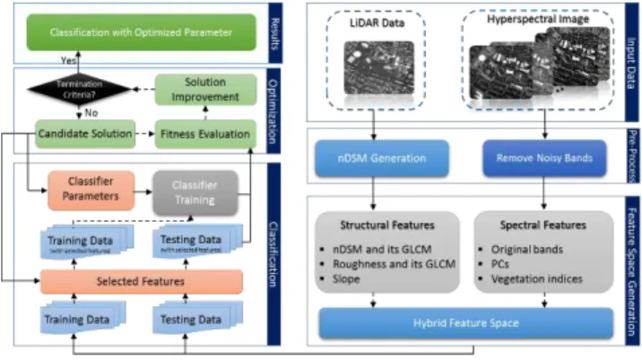
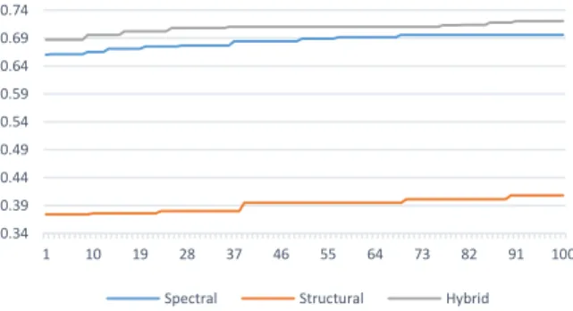
Based on the results of our proposed method, fusion of classifiers on two data sets improves classification accuracy. Based on these results, proposed classifier
So we introduce the Correctness Coefficient (CC) method. Also, several procedures for subpixel accuracy assessment were introduced. The numbers of binary images are
For this study, a classification of hyperspectral remote sensing data (CASI) was conducted for pervious and impervious areas within the City of Surrey road allowance
Classification and extraction of spatial features in urban areas using high- resolution multi-spectral imagery, IEEE Geoscience and Remote Sensing Letters ,
The paper presents a new methodology for the identification of asphalted pavement surfaces condition and the classification of the main types of asphalt defects using
