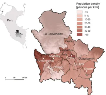
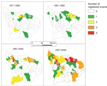
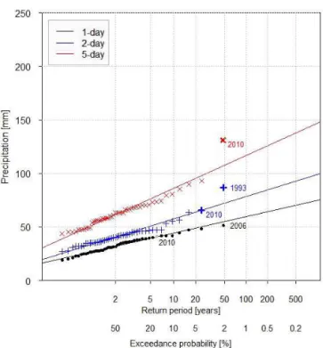
How useful and reliable are disaster databases in the context of climate and global change? A comparative case study analysis in Peru
Texto
Imagem


Documentos relacionados
Uma das explicações para a não utilização dos recursos do Fundo foi devido ao processo de reconstrução dos países europeus, e devido ao grande fluxo de capitais no
Diante do exposto, o desafio deste trabalho é demonstrar a viabilidade do planejamento de sistemas de energia por meio de um modelo que absorva as variáveis de cunho
O objetivo deste capítulo foi comparar os grânulos de pectina obtidos pelo processo de aglomeração utilizando soluções aquosas de goma arábica e sacarose e tentar relacionar as
Todavia, a falta de estudos sistematizados sôbre o assunto, a natureza necessàriamente fragmentária das deci sões judiciais a respeito, a existência dos textos legais calçados
Na segunda unidade, serão abor- dados os valores éticos e o código de ética do profissional em informática, e na terceira unidade, faremos um desfecho falando sobre a importância de
Compreender então esta relação do vídeo com a sociedade, seja ela expressa através de artistas, mais ou menos vanguardistas, que adentraram este mecanismo e o subverteram
O guião da entrevista semiestruturada foi articulado no sentido de conhecer os processos de comunicação, através das redes sociais, utilizados pelas organizações militares
Moreover in Raman spectroscopy, a single frequency of radiation is used to irradiate a sample unlike IR absorption which requires matching of the incident radiation to the
