1 INTRODUCTION
This work is the study of the parish of Cernache do Bonjardim, located in the municipality of Sertã, district of Castelo Branco, in the centre of Portugal. This parish was established on Janu-ary 5, 1544, and became a village on August 20, 1955 (Gonçalves, 2010).
Despite the existing monographs or the various works that refer Cernache, there aren’t any recent works or sufficiently detailed surveys on the territory and on the heritage of this parish. Until now, this parish was no subject of studies in the field that we analyzed and this work is an asset in this regard.
We have made an inventory of the heritage elements, and we propose an ordinance to group the assets found, with the objective to create the “heritage form sheets”, for an easier perception. The territory studied is consisted mainly of mountain areas, some of which are bathed by the Zêzere river or by the creek of Sertã. It is the second most populous parish in the municipality of Sertã (Gonçalves & Rosendahl, 2010).
It features mainly agricultural activities, having the forestry subsector a great representation. The secondary and tertiary sectors have been gaining preponderance (Gonçalves & Rosendahl, 2010), although the agriculture of survival continues to be part of the domestic economy.
The county continues with a high rate of illiterate people, compared to the national average (Gonçalves & Rosendahl, 2010) and we can observe the progressive desertification of the vil-lages.
The cultural heritage can be an engine of development of places like this, in a sustainable way, but to reach this aim, their knowledge and protection is pertinent.
Today there is several emerging heritage which needs to be protected. This work discloses what might be recognized as an emerging, essentially ethnological vernacular heritage. This her-itage is not currently recognized by the people who live there.
The divulgation and awareness of heritage is important, whatever their category might be. An example is the Law of Historical Heritage of Andalusia, which has been a great value since it
The (un)recognition of cultural heritage: the parish of Cernache
do Bonjardim, Portugal
M. M. C. S. Gonçalves
ISEDEC, Universidade do Algarve, Faro, Algarve, Portugal
M. T. Pérez Cano
ETSA, Universidad de Sevilla, Sevilla, Andalucía, España
ABSTRACT: In this parish of the centre of Portugal, heritage is essentially vernacular and could become a centre of knowledge and an attractive for the region. This heritage is not cur-rently recognized by the people who live there. The present article intends to make a survey of types of heritage of this territory, aiming to make it better known to allow its protection. This work discloses what might be recognized as an emerging, essentially ethnological heritage. The divulgation and awareness of heritage is important, whatever their category might be. When there is recognition of the heritage, this can now be seen in a different way. We hope that this work may serve to disseminate and preserve this heritage. In the future, this might become one of the bases of sustainable development in this region, helping to establish population and to improve their standard of living.
was established in 2007 with the inventory of goods of Cultural Interest, named BIC. When there is recognition of the heritage, this can now be seen in a different way.
We intend to make a survey of types of heritage of this territory, aiming to make it better known to allow that it may be protected. We hope that this work can serve to disseminate and preserve this heritage, and in the future, this might become one of the bases of sustainable de-velopment in this region, helping to establish population and to improve their standard of living. As a starting point we used the various existing publications on Cernache do Bonjardim, which are essentially monographs, verbal histories obtained through interviews with local peo-ple, recognition of land and field surveys.
We had to face several limitations, whether temporal or geographical and by the absence of certain elements, for example, registration and mapping in general. The lack of clutter is due to the fact that there was a fire in the Town-Hall of Sertã in 1917, having lost a huge estate making it very difficult to “remake” the story of the houses, for instance.
2 MEMORIES OF CERNACHE DO BONJARDIM
Based on field survey, we identified various heritage elements that were located using a GPS. At the same time, the bibliography search and interviews with local people allowed to consoli-date the knowledge of those elements. These steps – field survey, literature search and inter-views – can’t be addressed in isolation because they are interlinked and are mutually dependent. We have worked with military maps 1:25000 because it was more appropriate for the study of this territory (Gonçalves, 2010).
2.1 The Zêzere river and the parish of Cernache do Bonjardim
This territory is partially limited by the Zêzere river, one of the biggest Portuguese rivers, and its Castelo do Bode dam, downstream of this area (Gonçalves, 2010). This river has always been a natural border that people used, both as a mean of communication or as a mean of livelihood (fishing, mining, irrigation, for example) (Gonçalves, 2010). With the construction of Zêzere’s dam much heritage was submerged, such as the old bridge in Vale da Ursa and the conheiras (Gonçalves & Rosendahl, 2010), see section 3.
The construction of the dam of Castelo do Bode is a very important milestone in the study of spatial planning in this region. We could even split the study in this parish “before and after the dam” (Gonçalves & Rosendahl, 2011), or speaking in the “old river” and “new river”. The dam had a huge impact on the waterfront of the territory under study, within the landscape, economy, heritage and the modus vivendi of the populations (Gonçalves & Rosendahl, 2011).
In this area there are many creeks and springs, which makes it a region rich in water (Gon-çalves & Rosendahl, 2010), which might be exploited to create touristic tours, among others. An example of this heritage is the minas used for water supply (see section 3).
2.2 Heritage analysis methodology
The heritage analysis methodology adopted in Gonçalves (2010) is based on the work of Tor-rejais (2010) and consisted in the division of heritage into three categories (natural, intangible and tangible heritage) and each one into subcategories, for an easier understanding and identifi-cation of each element found in a given group:
Natural heritage:
o Forrestal heritage o Landscape heritage
o Natural medicinal mineral waters Intangible cultural heritage:
o Important people o Legends
Tangible cultural heritage: o Civil architecture:
Buildings with historical-cultural interest Farms and manor-houses
o Production architecture: Water supply Mills
Ovens for bread o Religious architecture:
Churches Chapels Edified groups o Urban equipment
Busts and statues
Fountains, drinking fountains and tanks Bridges
o Industrial heritage Conheiras
Wood based industries and dippers o Another edified heritage:
Castros Roman villas Foz da Sertã Bandstands
Based in this methodology, we have developed “heritage form-sheets” which contain several informations obtained for each element of heritage (Figure 1). We do not consider, however, that this list is complete, but most of the heritage elements can be included in these categories. Although we found many heritage elements, we present only one example of each one, and if they appear more than one instance, it means that they represent the possible variants in this group (Gonçalves, 2010).
For the natural heritage, the inventory sheet consists of the following topics, when applicable: category, location, classified heritage, property, environment, description and condition (Gon-çalves, 2010). Each element of the intangible cultural heritage was associated with an inventory sheet, which consists of the following topics, when applicable: to “important people” – catego-ry, title, place of birth, date of birth and death, biography; to “legends” – categocatego-ry, location, de-scription (Gonçalves, 2010). Each element of the tangible cultural heritage was associated with an inventory sheet, which consists of the following topics, when applicable: category, classifica-tion, locaclassifica-tion, address, classified heritage, property, initial use and current use or only use, framework, period of construction, type, materials, description, condition of conservation (just appreciation of the outdoors) (Gonçalves, 2010).
3 EXAMPLES OF THE HERITAGE ELEMENTS
We came to the conclusion that there are more heritage elements than might be expected ini-tially. It is easy to recognize a castle, but today there is several emerging heritage which needs also to be protected (Gonçalves, 2010).
3.1 Natural heritage
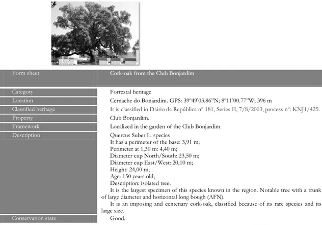
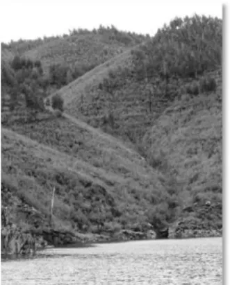
In this item we intend to do a survey of important plant specimens and landscapes of the par-ish. For the category of “Forrestal heritage”, we began a survey of forest specimens of patrimo-nial value. Examples: the cork-oak of the Club Bonjardim, which is classified and is a very large and old cork tree, which is rare in this region. In the “landscape heritage” category, we consid-ered landscapes as a whole, not just the forest or water courses, but the set. Example: lake of Castelo do Bode dam and its surrounding (Figure 2). In the category of “natural medicinal min-eral waters” was considered the only known minmin-eral spring: Foz da Sertã waters (Gonçalves, 2010).
Form sheet CCoorrkk--ooaakkffrroommtthheeCClluubbBBoonnjjaarrddiimm
Category Forrestal heritage
Location Cernache do Bonjardim. GPS: 39º49’03.86’’N; 8º11’00.77’’W; 396 m
Classified heritage It is classified in Diário da República nº 181, Series II, 7/8/2003, process nº: KNJ1/425.
Property Club Bonjardim.
Framework Localized in the garden of the Club Bonjardim.
Description Quercus Suber L. species
It has a perimeter of the base: 3,91 m; Perimeter at 1,30 m: 4,40 m; Diameter cup North/South: 23,50 m; Diameter cup East/West: 20,10 m; Height: 24,00 m;
Age: 150 years old; Description: isolated tree.
It is the largest specimen of this species known in the region. Notable tree with a trunk of large diameter and horizontal long bough (AFN).
It is an imposing and centenary cork-oak, classified because of its rare species and its large size.
Conservation state Good.
Figure 1. Example of a heritage form-sheet or inventory sheet. Source: Gonçalves, 2010.
Figure 2. Lake of Castelo do Bode dam and its surrounding. Source: Gonçalves, 2010.
Located in the far north and west of the parish of Cernache do Bonjardim, the lake of Castelo do Bode dam extends from this dam, downstream, to the Bouçã dam, upstream. Inserted in one of Europe’s largest forest patches and protected by a group of mountains forming a natural wall (Lousã and Espinhal, Melriça, Alvelo and Cabeço Rainha, Alvaiázere), almost equidistant about 30 km away, the region of Cernache do Bonjardim is characterized by steep slopes and deep and embedded valleys, cut by numerous creeks flowing in different directions, providing scenic panoramas of gentle natural beauty (Gonçalves, 2010). It is not inventoried.
Near the mouth of the Ribeira da Sertã and near the village of the same name, exists here a spring of thermal waters that have been exploited but that currently is completely abandoned. There was an exploration of medicinal mineral waters, a water bottled industry and a thermal hotel. The Foz da Sertã water is the only known medicinal mineral water that exists in the coun-ty (Gonçalves, 2010).
3.2 Intangible cultural heritage
This item is intended to give examples of types of elements of the intangible heritage of the parish of Cernache do Bonjardim. For the category “important people”, we have done the lifting of the worthies of the parish, especially Nuno Álvares Pereira for being a national hero and a
re-cently canonized saint. In the “legends” category, we began a survey of existing legends in the parish, having been elected the legend of St. Maria Madalena and St. Macário (Gonçalves, 2010). These are not inventoried.
Nuno Álvares Pereira, also known as the Holy Constable, Beato Nuno de Santa Maria, or simply Nun'Álvares, was born in Cernache do Bonjardim on June, 24th 1360 and died on 1st No-vember 1431. It was a fourteenth-century Portuguese general who played a key role in the crisis of 1383-1385, where Portugal played its independence from Castile. Nuno Álvares Pereira was also 2nd count of Arraiolos, 7th count of Barcelos and 3th count of Ourém. Camões, on literal or allegorical mean, expressed or implied, refers the Constable no less than 14 times in “The Lusi-ads”. There is a sculpture of him in the Arch of Street Augusta and in Praça do Comércio in Lisbon, another in the castle of Ourém and another in Cernache. He was beatified on 23rd of January 1918 and was canonized by Pope Benedict XVI on April 26th, 2009 (Gonçalves, 2010).
The legend of St. Maria Madalena and St. Macário is a legend that tells us the martyrdom of these two saints and their brothers. It is linked to the chapel “da Santa”. This legend says that more five chapels were erected on top of several hills, where the brothers can see each other – Nossa Senhora da Nazaré in Palhais, St. Ana in Cumeada, Nossa Senhora dos Remédios in Sertã, Nossa Senhora da Confiança in Pedrógão Pequeno, Nossa Senhora da Graça and St. Neu-tel in Figueiró dos Vinhos (Gonçalves, 2010).
3.3 Tangible cultural heritage
The inventory of civil architecture presents buildings – private or public, rural or erudite – that stand out from all the houses by their biggest patrimonial value, contributing to build up various types of architectural sites (Gonçalves, 2010).
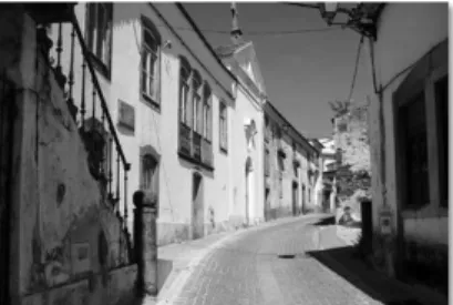
For the “public character buildings” category, we considered the examples of Club Bonjardim and movie-theatre Taborda; for the category “buildings with historical-cultural interest” we con-sidered the example of the Seminar of the Missions; for the category “farms and manor-houses” we considered the examples of Santo António farm and Rua Torta Manor (Figure 3) (Gon-çalves, 2010).
Figure 3. The Manor of Rua Torta. Source: Gonçalves, 2010.
The Club Bonjardim is a private association based in Cernache do Bonjardim. It was founded on February 20th, 1885. At its building is located the movie-theater Taborda. It has a cultural and recreational architecture, from the end of the nineteenth century. The movie-theater consists of three volumes: the core, corresponding to the room, the side, housing support services to the public, as bar and clubhouse, and the eastside, with dependencies to support the theatre, as the rehearsal room, dressing rooms and toilets (SIPA). Inventoried, a protection does not exist.
The Mission Seminary was built in XIX/XX century. The architect is unknown (SIPA). It is a building that was the intellectual centre of the region, as a public school. It has a great im-portance in the formation of religious and lay missionaries to Africa and had several names: Seminary of the Missions, Missions Colonial Institute and currently, the Portuguese Missionary Society or Missionary Society Boa Nova. It is inventoried, but a protection does not exist.
The Santo António farm is constituted by the main house and the chapel of St. António, which is a chapel erected within the limits of the property. According to SIPA the time of the chapel construction was likely the eighteenth century. Only the chapel is inventoried but a pro-tection does not exist.
The Manor of Rua Torta was originally the home of the Cernache’s Morgado. Presents a res-idential, baroque and nineteenth century architecture (SIPA). It includes a chapel in the building with the date of 1775 carved on the façade. This will probably be the date of construction of the house, with changes in the nineteenth and twentieth centuries (Gonçalves, 2010). The set is in-ventoried but there is no protection.
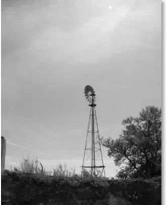
In the inventory of production architecture we began the survey of all equipment used in processing raw materials into finished products or semi-finals for immediate consumption or for supply to other industries. For the category of “water supply” we’ve considered the examples of one mina (Figure 4), a wind mill (Figure 5) and a well. For the “mills” category we considered the mills from the village Moinhos da Ribeira and for the “ovens for bread” category we’ve considered an oven for bread existing in the village Brejo da Correia (Gonçalves, 2010).
Figure 4. Example of a mina. Source: Gonçalves, 2010.
Figure 5. Example of a wind mill. Source: Gonçalves, 2010.
A mina is a small gallery inside the open ground where the water is retained (Gonçalves & Rosendahl, 2010): it consists of a horizontal hole that goes into the earth, with a little wall at the entrance to serve as a reservoir. It is a typical form of capturing groundwater in this region.
A wind mill is another typical way to capture groundwater. It is a device to pump groundwa-ter to the surface, taking advantage of the wind (Gonçalves, 2010).
What makes these wells so typical is the gazebo that normally exists on top, where climbing plants grow making shading. The type of device for drawing water is also very common in this area. This kind of wells characterized this region very well (Gonçalves, 2010).
The mills of the village of Moinhos da Ribeira probably stood next to the bed of creek of Sertã, to harness water power for grinding grain. The literature speaks of cereal crops in the re-gion. Being this village next to a water course, this was used to drive the millstones and grind grain. They are lost, probably submerged (Gonçalves, 2010).
This bread oven in Brejo da Correia is situated on ruins of houses. Usually one or more hous-es had oven for baking bread and it is usual that there still are some. It was usual to have this
kind of bread ovens at home, where they cooked the triga-milha, a bread made with wheat and corn flour, cereals that grew in this region (Gonçalves, 2010).
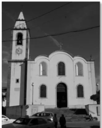
For the inventory of religious architecture therewas made a survey of all existing public and private temples, as well as now inexistent, which represent a long list. For the “churches” cate-gory we considered the example of St. Sebastião church or parish church (Figure 6). For the “chapels” category we considered the chapel of Nossa Senhora da Estrela and for “edified groups” we considered the convent of St. José or Águias farm (Gonçalves, 2010).
Figure 6. Church of St Sebastian or parish church. Source: Gonçalves, 2010.
The church of St. Sebastião is the main church in this parish. It was built in 1554/1555, the date of the creation of the parish of St. Sebastião of Cernache do Bonjardim and the construc-tion of the church. It has a gilded altar and screens of Bento Coelho da Silveira (1630-1708) and a religious, mannerist and baroque architecture (SIPA). It is classified.
About the chapel of Nossa Senhora da Estrela, Teixeira (1905) says: “it had a rich gilded altar which is raised in the parish church of Cernache and reveals a great antiquity. Brother Lucas de Santa Catarina, in his work printed in 1730 and entitled «Memoirs of the Military Order of St. John of Malta», speaking of Nossa Senhora da Estrela, says it was the tradition that the Tem-plars lived there. He was also upright a Brotherhood in 1821”. It is now disappeared.
The convent of St. José was founded in 1699 as a simple mental hospital where the religious of the convent of Sertã came to convalesce from their illnesses. It was only transformed into a convent in 1720 (Teixeira, 1905). The oldest document that, about this convent, this author found in the Torre do Tombo, dated back to 1707. It is inventoried but there is no protection.
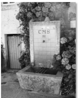
For the urban equipment inventory we started the survey of busts, statues, fountains, drinking fountains, tanks and bridges, existing elements that give a specific dimension to rural communi-ties. In the “busts and statues” category we considered the example of Nuno Álvares statue. For the category “fountains, drinking fountains and tanks” we considered the Outeiro’s fountain (Figure 7), the Eira’s drinking fountain (Figure 8) and a tank from Matos do Pampilhal (Figure 9). And for “bridges” category we considered the Vale da Ursa’s bridge (Gonçalves, 2010).
The statue of Nuno Álvares is from the twentieth century, of the sculptor José Manuel Vala-das Corial, of commemorative, modernist architecture. The statue is in bronze on a concrete plinth coated with granite. It has the meaning or symbolism and historical memory of the birth-place of Nuno Álvares (SIPA). It is inventoried but there’s no protection.
The Outeiro’s fountain has also a public washing. This is an interesting example because it is partially hidden, being necessary to descend a small staircase to access it (Gonçalves, 2010). It is not inventoried.
The drinking fountain of Eira is built of concrete, with some tile and coated, with just one spring. It served to the public water supply (Gonçalves, 2010). It is not inventoried.
The Matos do Pampilhal’s tank it is a tank form to wash clothes. It is a reservoir in which sloping stones are placed to wash clothes. Typical coverage is also with a gazebo that is ordinar-ily with vines as a shading device (Gonçalves, 2010). It is not inventoried.
Figure 7. Outeiro’s fountain. Source: Gonçalves, 2010.
Figura 8. Eira’s drinking fountain. Source: Gonçalves, 2010.
Figure 9. Tank in Matos do Pampilhal. Source: Gonçalves, 2010.
The Vale da Ursa’s bridge is located on the river Zêzere, upstream of the dam of Castelo do Bode. It is a reinforced concrete bridge with spans supported by piers. It was built in 1951 with a project of Engineer Edgar Cardoso. This bridge replaces the existing bridge at the same loca-tion, but slightly further downstream, which was of stone and iron, built about 1895, which was submerged as a result of filling the reservoir of the dam of Castelo do Bode (Gonçalves, 2010). It is not inventoried.
In the industrial heritage inventory was initiated a survey of all sites relating to conheiras, the zorros and to the activity of wood based industry and dippers. For the example of
“conhei-ras” category we’ve choose the Várzea de Pedro Mouro’s conheira (Figure 10) and for the
“wood based industries and dippers” category we’ve choose the creek of Sertã’s zorro (Figure 11) (Gonçalves, 2010).
A conheira is, for Batata (1998), “an old gold alluvial exploration, which may have been ex-ploited since the Chalcolithic to the XX century”. According to the same author, a conheira is characterized by “typical lots of large pebbles (conhos). The sands were washed and released di-rectly to the river”. This conheira is almost entirely covered by the waters of the Castelo do Bode lake, leaving only a few mounds of conhos (Batata, 1998).
A zorro is a groove in the side of a hill where the trunks of cuttrees were slipped, reaching a water line, where they came down with the force of the stream to the place of sawmills. It was a way to transport timber using a natural resource. The early use was to bring down the trunks of pine trees to the creek of Sertã, to go down to the Zêzere and probably even for the Tejo river to reach areas of sawmills. Currently itis used to forestry plantation (Gonçalves, 2010).
Figure 10. Várzea de Pedro Mouro’s conheira. Source: Gonçalves, 2010.
Figure 11. Creek of Sertã’s zorro. Source: Gonçalves, 2010.
In the another edified heritage categorywe initiated a survey of all local heritage with patri-monial value which was not included in the previous sections. For the “castros” category we have chosen the St. Maria Madalena’s castro. For the “roman villas” we’ve choose the Vila Gaia. The house of the “Foz da Sertã water” was choose for an example of “Foz da Sertã” cate-gory and the bandstand from Quintã was the example of “bandstand” catecate-gory (Gonçalves, 2010).
A castro was a town in a high place, that served as a defence against invaders. Batata (1998) says, “overall, it is a village set to be surrounded with at least one wall, over which no one has any kind of dating. By the materials found there, the castro was occupied from the Late Bronze/1st Iron Age, through the 2nd Iron Age and possibly by the Romans, or their influence. It is a large village, situated on a prominent hill that dominates the plateau zone of Cernache do Bonjardim”.
Batata & Arsénio (2006) state that “there would be a secondary road in Roman times (if not before) that would link Dornes to Sertã. In Sertã, the path would begin, would go through Cer-nache, turned around the nascent of the St. Maria Madalena’s castro, Mendeira, Vila Gaia, crossing the river to Dornes, rising to Paio Mendes, Pias, Ceras, until traces back on the main path from Olisipo (Lisbon) to Bracara Augusta (Braga)”. We think that Vila Gaia would be a Roman villa that could serve as a sort of inn that existed in this Roman road. No excavations were made in this place (Gonçalves, 2010). It is not inventoried.
In the house of Foz da Sertã waters there wasthe reception of the Foz da Sertã Hotel, were customers could stay while waiting for the river transport to give entry to the hotel (Gonçalves, 2010). It is ruined and it’s not inventoried.
The bandstands are typically used to install a brass band, a musical ensemble, serving as dance zone or as an area to advertise something. This bandstand is located right in front of the chapel of St. Bento in Quintã, in the party place (Gonçalves, 2010). It is not inventoried.
4 CONCLUSIONS
The parish of Cernache do Bonjardim is located in an area with many forests and bathed by the Zêzere river and the creek of Sertã. In this section the river is included in the lake of Castelo do Bode dam, thus forming a huge mirror of water with great tourist potential. This parish, however, suffers from the problems of interiority, including poor roads and desertification. This contributed to the subsequent disinterest in this area, which remains isolated due to a near-zero accessibility, resulting in the lack of jobs which promotes migration and the consequent depopu-lation. Nevertheless, the past of Cernache was glorious, given its size. The Seminar of the Mis-sions contributed greatly to promote the education in this parish and in the bordering regions (Gonçalves, 2010).
We prepared a methodical collection of cultural and natural heritage of this parish, though in this paper we present only one example of each type. We produced also “heritage form-sheets” with the objective to order the survey made by us. It was a surprise because we never thought to find so much (Gonçalves, 2010). The knowledge of this heritage is essential not only to protect it but also to enjoy it.
It would be important to propose measures that aim to fix the population. These measures would go through the utilization of the existing heritage. This could be the basis for creating jobs and improving the living conditions of populations in a sustainable manner.
At the level of tourism use, although there is potential and something is being done, it is nec-essary to make the required preparations so that there is a structure that meets the needs but in a way not to lose what exists. Then, a good advertising campaign should be made to spread the region.
The general mentality of the population is that there is nothing of interest here. This is ex-plained to be a largely agricultural area, with an aging population, witha diverse and rich herit-age, but as it is always there, itsimply is not valued. We would like to change this mentality and preserve the memories of this territory. We hope this work will help us in this arduous task.
REFERENCES
(AFN) Ministério da Agricultura, Mar, Ambiente e Ordenamento do Território, Autoridade Florestal Na-cional. Árvores de interesse publico. Consulted at September 2010, in http://www.afn.min-agricultura.pt/portal/.
Batata, C. 1998. Carta arqueológica do concelho da Sertã. Sertã: Câmara Municipal da Sertã.
Batata, C., & Arsénio, P. 2006. Carta Arqueológica do concelho de Ferreira do Zêzere. Ferreira do Zêze-re: Câmara Municipal de Ferreira do Zêzere.
Gonçalves, M. M. & Rosendahl, S. 2010. Análise de vários factores que influenciam a definição das cha-ves do território: o caso da freguesia de Cernache do Bonjardim. Actas de PLURIS2010, 4º Congresso Luso-Brasileiro para o Planeamento Urbano, Regional, Integrado, Sustentável. Faro: Edições da Uni-versidade do Minho.
Gonçalves, M. M. & Rosendahl, S. 2011. Impacte das grandes obras de engenharia. A barragem do Caste-lo do Bode e a freguesia de Cernache do Bonjardim. Actas de ICEUBI2011 International Conference on Engineering UBI2011 Innovation & Development. Covilhã: Edições UBI 2011.
Gonçalves, M. M. 2010. Freguesia de Cernache do Bonjardim. Território y patrimonio. Work presented to the Escuela Tecnica Superior de Arquitectura (ETSA) or Sevilla university, Spain, to obtain the Di-ploma de Estudios Avanzados, under the guidance of Dr. María Teresa Pérez Cano. Not published. (SIPA) Sociedade de Informação para o Património Arquitectónico. Consulted at June 2010, in
http://www.monumentos.pt
Teixeira, C. S. 1905. Sernache do Bom Jardim: traços monographicos. Lisboa: Papelaria La Bécarre Ti-pografia.
Torrejais, A. 2010. Inventário do património do concelho de Ferreira do Zêzere. Consulted at June 2010, in http://www.ferreiradigital.com.