www.ocean-sci.net/12/471/2016/ doi:10.5194/os-12-471-2016
© Author(s) 2016. CC Attribution 3.0 License.
Jason continuity of services: continuing the Jason altimeter data
records as Copernicus Sentinel-6
Remko Scharroo, Hans Bonekamp, Christelle Ponsard, François Parisot, Axel von Engeln, Milen Tahtadjiev, Kristiaan de Vriendt, and François Montagner
European Organisation for the Exploitation of Meteorological Satellites (EUMETSAT), Darmstadt, Germany Correspondence to:Remko Scharroo ([email protected])
Received: 21 September 2015 – Published in Ocean Sci. Discuss.: 3 December 2015 Revised: 15 February 2016 – Accepted: 14 March 2016 – Published: 1 April 2016
Abstract. The Sentinel-6 mission is proposed as a multi-partner programme to continue the Jason satellite altime-ter data services beyond the Jason-2 and Jason-3 missions. The Sentinel-6 mission programme consists of two identi-cal satellites flying in sequence to prolong the climate data record of sea level accumulated by the TOPEX/Poseidon, Jason-1, Jason-2, and Jason-3 missions from 2020 to be-yond 2030. The Sentinel-6 mission intends to maintain these services in a fully operational manner. A key feature is the simultaneous pulse-limited and synthetic aperture radar processing allowing direct and continuous comparisons of the sea surface height measurements based on these pro-cessing methods and providing backward compatibility. The Sentinel-6 mission will also include radio occultation user services.
1 Introduction
The Sentinel-6 mission is proposed as a multi-partner pro-gramme to continue the Jason altimeter data services beyond Jason-2, currently fully operational, and Jason-3, currently pre-operational. The Jason Continuity of Service (Jason-CS) programme constitutes EUMETSAT’s contribution to the Copernicus Sentinel-6 mission to be developed and im-plemented through a partnership between the EU, ESA, EUMETSAT, NASA, and NOAA. From 2020 to beyond 2030, the Sentinel-6 mission will uniquely extend the climate record of sea-level measurements accumulated since 1992 by TOPEX/Poseidon (e.g. Fu et al., 1994), Jason-1 (e.g. Ménard and Fu, 2001), 2 (e.g. Lambin et al., 2010), and Jason-3. A prime mission objective is to continue this long global
sea-level time series with an error on the sea level trend of less than 1 mm yr−1. The Sentinel-6 mission will also be an essential observing system for operational oceanography and seasonal forecasts in Europe and beyond. It will provide mea-surements of sea surface height, significant wave height, and wind speed without degradation in precision and accuracy compared to the currently flying Jason-2 mission. As such, like its predecessors, the proposed mission will provide key user measurement services for sea-level-rise monitoring, op-erational oceanography, and marine meteorology. These ser-vices will be aligned with those of the Sentinel-3 missions (e.g. Donlon et al., 2012), which will be operational in the same era, see Fig. 1.
In addition to the altimeter data service, Sentinel-6 will also include a GNSS radio occultation instrument (GNSS-RO) as a secondary payload, taking advantage of the non-sun-synchronous orbit of Sentinel-6. The GNSS-RO mea-surements will provide information on atmospheric pressure, temperature and water vapour as well as ionospheric data. The radio occultation data service primarily addresses the needs of meteorological and climate users.
Figure 1.Overview of the current and future satellite altimeter mis-sions (Sources: WMO and CEOS).
2 Programmatic set-up
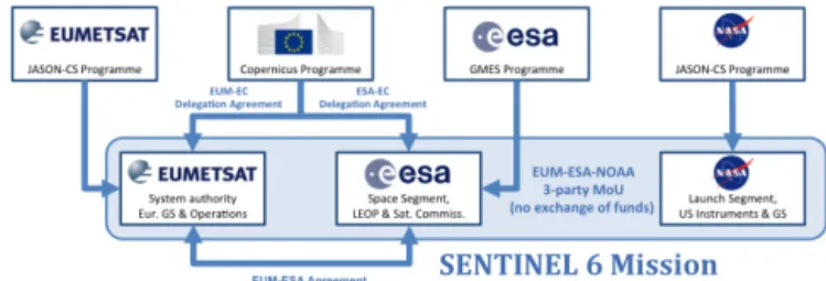
Figure 2 outlines the multi-partner programme and agree-ment set-up underlying the Sentinel-6 missions. The Euro-pean contribution will be implemented through the combina-tion of the ESA Global Monitoring for Environment and Se-curity (GMES) Segment 3 programme (GSC-3), the optional EUMETSAT Jason-CS programme and the EU Copernicus Programme, for the joint benefits of the meteorological and Copernicus user communities in Europe. In addition, on be-half of the United States, NASA and NOAA are developing a dedicated Jason-CS programme. The following high-level sharing of responsibilities is envisaged (which may still be subject to some changes):
– EUMETSAT is the system authority and is responsi-ble for the Sentinel-6 ground segment development and operations preparation. EUMETSAT will also carry out the operations build-up and operations of the Sentinel-6 system including both satellites and delivery of data services to Copernicus service providers and users on behalf of the EU.
– ESA is responsible for the development of the first Jason-CS satellite and the instruments prototype pro-cessors as well as for the procurement of the recurrent satellite on behalf of EUMETSAT and the EU.
– NASA will deliver the US payload instruments for both satellites and will provide ground segment development support, launch services, and contributions to opera-tions.
The three space agencies will share the responsibility for the science team coordination and the calibration and/or vali-dation activities, with EC being involved in the interactions with the science teams. In addition, agreements will be con-cluded between EUMETSAT and CNES and between NOAA and NASA for system and science expertise support.
Figure 2.The multi-partner programme and agreement set-up un-derlying the Sentinel-6 mission.
3 Mission objectives
Sentinel-6 will be a truly operational mission in all aspects of its main user services. Hence, full emphasis is put on re-duction of downtime to a minimum, on timely distribution of data products, and on high quality and reliability of the measurement data. The mission will also include support to information service providers and major reprocessing activi-ties.
The Sentinel-6 product suite is currently being detailed. The baseline is to provide a product suite that will enable an optimal combination with products from other altimeter mis-sions. This is particularly pursued for combining Sentinel-6 with the Sentinel-3 Ku/C radar altimeter (SRAL) missions. Next to the conventional Level 2 products, known as geo-physical data records (GDRs) for the Jason missions, the Sentinel-6 product suite will include Level 1 products aimed at the further study of the intrinsic altimeter waveforms and development and innovative processing techniques. Also, the generation of higher-level single-mission products (Level 2P and Level 3) are supported in order to serve mainly the ocean modelling community.
Sentinel-6 products are to meet high standards, such that they will be of sufficient quality to serve as the high precision reference mission for other altimeter missions. It has been formally required that the mission performance shall not be worse than the known performance of Jason-2. With the cur-rent design however the expectation is that the Sentinel-6 mission will outperform Jason-2 on many aspects and will form a reliable state of the art reference for various other al-timeter missions in the near future.
The Sentinel-6 products will also maintain their quality closer to the coastline than products from its predecessor Ja-son missions (e.g. Raney, 1998; Gommenginger et al., 2012; Halimi et al., 2014). This, among other techniques, will be fa-cilitated by replacing the conventional low-resolution mode (LRM) altimeter by one that has along-track Synthetic Aper-ture Radar (SAR) capabilities.
profiles. In addition, ionospheric data are also provided up to 500 km altitude.
4 Mission characteristics
The Sentinel-6 Space Segment consists of two successive Jason-CS satellites (A and B), based on the CryoSat-2 her-itage platform, with some tailoring to specific needs of the Sentinel-6 mission. The satellites will embark the following main payload:
– a radar altimeter (Poseidon-4), to measure the range be-tween the satellite and the mean ocean surface, deter-mine significant wave height and wind speed, and pro-vide the correction for the altimeter range path delay in the ionosphere by using signals at two distinct frequen-cies (Ku-band and C-band);
– a microwave radiometer (AMR-C), to provide a correc-tion for the wet tropospheric path delay for the altimeter range measurement;
– Precise orbit determination (POD) instruments – namely a Global Navigation Satellite System and precise orbit determination receiver (GNSS-POD), a Doppler Orbitography and Radiopositioning Inte-grated by Satellite instrument (DORIS), and a laser retroreflector array (LRA) – to provide with high accu-racy and precision a measurement of the orbital position as needed for the conversion of the measurement of al-timeter range into a sea level;
– a radio occultation instrument (GNSS-RO), to provide (with high vertical resolution) all-weather atmospheric and ionospheric soundings by tracking GNSS satellites. The latter instrument is added to Sentinel-6 as a secondary mission to provide radio occultation observation services to meteorological users. However, the primary altimeter mis-sion supported by the other instruments takes priority in all design and mission planning.
It is important to remark that the Poseidon-4 radar altime-ter has evolved significantly from the Poseidon-3A and -3B instruments on board Jason-2 and -3, respectively. In addi-tion to a convenaddi-tional pulse-width limited processing, also known as low-resolution mode, the Poseidon-4 on board the Jason-CS satellites will also have the facility of simultane-ous high-resolution (HR) processing, generally referred to as Synthetic Aperture Radar processing (or SAR mode), as discussed in Sect. 6. This HR processing will provide fur-ther service alignment with the SAR mode of the Sentinel-3 SRAL mission.
The Jason-CS satellites will fly in the same orbit as its predecessors, TOPEX/Poseidon and the Jason missions (see Table 1). This is a non-sun-synchronous orbit with nominal altitude of 1336 km and 66◦inclination. The orbit period is
Table 1.Parameters of the Jason-CS orbit.
Quantity Value
Semi-major axis 7714.4278 km
Eccentricity 0.000095
Argument of perigee 270.8268◦ Inclination (non-sun-synchronous) 66.039◦ Reference altitude (equatorial) 1336 km
Nodal period 6745.72 s
Orbits per day 12.81
Repeat cycle 9.9156 days
Number of orbits per cycle 127 Number of passes per cycle 254 Ground track separation at equator 315 km Acute angle at equator crossings 39.5◦
Orbital velocity 7.2 km s−1
Ground track velocity 5.8 km s−1
112 min and 26 s and the ground track cycle repeats approxi-mately every 9 days and 22 h. Because of the relatively large ground track spacing of 315 km at the equator, Jason-CS alone will not be able to satisfy the sampling requirements for mesoscale oceanography. Thus, the Sentinel-6 mission is co-ordinated with other altimeter missions, chiefly the Sentinel-3 mission, to provide together a complementary spatiotem-poral sampling of the oceans and serve as a high-precision reference to sea-level-change studies.
5 Product definition and product services 5.1 Altimeter product definition
The raw data downlinked from the satellite consist of a serial stream of data bits embedded within a framework of trans-fer frames. This level of data, which may be temporarily archived at the reception station, is not readable by a general-purpose computer and not included in the set of product-level definitions. The data are then converted onwards to Level 0 and higher.
Level 0 products are computer-readable data directly rep-resenting the output of the on-board instrument in its native data structure and in native units (e.g. clock cycle counts), after extraction from the downlinked data stream. Data are chronologically ordered with any overlapping (duplicate) data removed. Quality flags related to the reception and de-coding process may be appended.
wave-forms. A Level 1b-S product, similar to what is produced for Sentinel-3 is not envisioned, however, software will be provided to derive these from the Level 1a product.
Level 2 products maintain the same time structure and sampling as the Level 1 products from which they are de-rived. The measurement data are converted into geophysi-cal quantities, and combined with auxiliary input data from other sources (such as geophysical corrections coming from meteorological models) to yield directly useful geophysical parameters, e.g. sea surface height (SSH), significant wave height (SWH), and wind speed. The auxiliary data parame-ters and geophysical corrections are appended. For altime-try, Level 2 products contain measurements of SWH, wind speed, and SSH, at a high rate of about 20 measurements per second, which are then averaged along-track to form one averaged measurement approximately every 1 s. These prod-ucts are thus equivalent to the GDRs for the Jason missions. The data structures of Level 1 and Level 2 will be similar, making it easy for users to combine the waveform informa-tion in the Level 1 products with the geophysical informainforma-tion stored in the Level 2 products.
Level 2P products are enhanced Level 2 products, aimed at harmonisation between missions, e.g. applying the same geophysical corrections across the missions, or applying ex-ternally derived biases to the data in case they have not been applied yet in the operational Level 2 products.
Level 3 products contain geophysical parameters that have been spatially and/or temporally resampled or corrected. This may include averaging over multiple measurements.
Level 4 products are described as thematic data, and are generally gridded parameters that have been derived from the analysis of the satellite measurements but are not directly de-rived from them. These products are elaborated by service providers and users and are not delivered by the Sentinel-6 programme.
5.2 Radio occultation product definition
For the GNSS-RO, Level 0 products will contain raw data. At Level 1a, phase and amplitude data as well as the satellite orbits of the occultation are provided. The Level 1b products will include the main variables for assimilation, such as the vertical bending angle profile. At Level 2, temperature and water vapour profiles are provided, while Level 3 products will have been spatially and/or temporally resampled and av-eraged.
5.3 Product services
Based on the synthesis of the operational applications var-ious product services are identified. Tables 2 and 3 match the applications with the appropriate product levels. Since the requirements on the timeliness and quality of the prod-ucts may vary by application, the Sentinel-6 mission will in-clude operational user product services at three different
la-tencies: Near-Real-Time (NRT), Short-Time-Critical (STC), and Non-Time-Critical (NTC). Details about the various product services are given below and in Table 4. These laten-cies map onto the various applications for which the services are set-up. The latencies also effectively govern the quality of the auxiliary data used in their generation, with better-quality data available after a longer elapsed time.
The naming of these services (characterised by product la-tencies) are in common with those of the Sentinel-3 ocean surface topography mission. Also the availability of HR al-timeter measurements (also known as SAR mode) and the wider services within the Copernicus programme affected the rationale behind some product definitions.
5.4 Near-Real-Time altimetry service (ALT-NRT)
The Near-Real-Time altimetry product service (ALT-NRT) delivers Level 2 products within 3 h after sensing. These products will be produced using the best possible algorithms, external data and orbit determination that are available in a short time span. Because of the reduced time allowed for the generation of NRT and STC data, it will often be necessary to rely on alternative data sources (e.g. predicted or clima-tological values) for auxiliary data like altimeter range cor-rections. The quality of the orbit determination will also be reduced for the shorter latencies. Nonetheless, the algorithms used for the production of Level 2 data from Level 1 are ex-pected to be the same in all cases.
In addition, to provide NRT data in the fastest possible way, data will not be provided in consolidated products with a length of half an orbit (as is the case for STC and NTC), but will rather be produced in smaller granules.
This service requires dissemination to Numerical Weather Predication (NWP) centres and is mainly used for marine meteorology, air–sea interaction studies, and real-time oper-ational oceanography.
As well as serving operational users, these NRT products may be used in the generation of some auxiliary data (e.g. bias corrections) for STC and NTC products. The main ob-jective of the ALT-NRT product service is to provide infor-mation on the sea-state, e.g. significant wave height and wind speed, but also on sea-surface height.
5.5 Short-Time-Critical altimetry product service (ALT-STC)
The Short-Time-Critical altimetry product service (ALT-STC) delivers Level 2 products within 36 h after sensing, which enables consolidation of some auxiliary data (e.g. pre-liminary restituted orbit data). Products are mainly used for operational oceanography and geophysical studies.
Table 2.Mapping of the main application areas on the altimetry product services (Level 1 and Level 2). The mapping for Level 3 products is equivalent to the one of the Level 2 products (+is essential;is beneficial;−is less important).
Application category NRT STC NTC
Product level Level 1 Level 2 Level 1 Level 2 Level 1 Level 2
Marine meteorology − + − − − −
Operational oceanography − + − + − +
Climate change − − − − − +
Research and remote-sensing science − + +
Table 3.Mapping of the main application areas on the radio occultation product services (+is essential;is beneficial;−is less important).
Category NRT NTC
Product level Level 1 Level 2 Level 1 Level 2
Numerical weather prediction + + − −
Climate change − − + +
Research and remote sensing science + +
delay for the provision of external data and orbit determina-tion. By reducing the allowed time for the generation of these data, their quality is expected to reduce accordingly. This is likely to be particularly true for the orbit determination.
The main objective of the ALT-STC product service is to support operational oceanography, i.e. improve ocean state analysis, forecasts, and hindcasts produced by numerical ocean prediction (NOP) systems assimilating sea surface height measurements derived from a multi-mission constel-lation of spaceborne altimeters.
Level 3 products contain geophysical parameters that have been spatially and/or temporally resampled or corrected. This may include averaging over multiple measurements. They are primarily intended for ocean modelling services. At this point, Level 3 data will only be provided with short time critical latency.
5.6 Non-Time-Critical altimetry product service (ALT-NTC)
The Non-Time-Critical altimetry product service (ALT-NTC) delivers Level 2 products within 60 days after sens-ing, this additional delay allowing the further consolidation of some auxiliary data (e.g. precise orbit data, radiometer cal-ibration) leading to higher accuracy of SSH products.
These products will be subject to regular reprocessing as better information about instrumentation biases, precise or-bits, and geophysical corrections become available.
The main objective of the ALT-NTC product service is to provide information on ocean topography and mean sea level in support of ocean and climate monitoring services.
5.7 Near-Real-Time radio occultation product service (RO-NRT)
The Near-Real-Time radio occultation product service (RO-NRT) delivers Level 1b and Level 2 products less than 3 h after sensing, for direct assimilation into NWP models. It will be provided by the US partners of the programme.
The main objective of the RO-NRT product service is to provide bending angles or refractivity profiles, which con-tain information on atmospheric temperature, pressure, and humidity, for assimilation by NWP models. Further RO-NRT Level 2 products are e.g. tropopause height, planetary bound-ary layer height, and ionospheric information (gravity wave information is also being discussed).
5.8 Non-Time-Critical radio occultation product service (RO-NTC)
The Non-Time-Critical radio occultation product service (RO-NTC) delivers Level 1b and Level 2 products within 60 days after sensing. This additional delay allows using longer time series of the instrument to obtain improved precise orbit determination and clock data for the satellite, as well as us-ing updated auxiliary data (e.g. precise orbit and clock data for the GNSS satellites).
The main objective of the RO-NTC is to deliver the same products as the RO-NRT service but with higher precision, making this service particularly valuable for climate studies, including assimilation in re-analysis models.
Table 4.Summary of the Sentinel-6 product suite for altimetry and radio occultation.
User data access
Resolution Service name Format EUMETCast GTS ftp Archive
Low (LRM) NTC NetCDF – – – L1b, L2
STC NetCDF – – L1b L1b, L2, L2P, L3
NRT NetCDF L2 (std+red) – – L0, L2
NRT BUFR L2 (red) L2 – L2
High (SAR) NTC NetCDF – – – L1b, L2
STC NetCDF – – L1a, L1b L1a, L1b, L2, L2P, L3
NRT NetCDF L2 (std+red) – – L0, L2
NRT BUFR L2 (red) L2 – L2
Radio occultation NTC NetCDF – – – L1b, L2
NTC BUFR – – – L1b, L2
NRT NetCDF – – – L0, L1b, L2
NRT BUFR – L1b, L2 – L1b, L2
std is standard product with 1 and 20 Hz data; red is reduced product with 1 Hz data only; Ln is Leveln.
Figure 3.Schematic diagram of the timing of transmit (red) and receive (green) pulses in case of conventional LRM altimetry (e.g. Jason-2, top), SAR burst mode altimetry (e.g. Sentinel-3, middle), and interleaved mode (Jason-CS, bottom).
Facility (ROM SAF) is responsible for processing these data further to Level 2 (and also to Level 3 within their climate service). The other RO-NTC service will be provided by the US partners of the programme.
6 Interleaved SAR mode
As indicated in Sect. 4, the Poseidon-4 radar altimeter system can operate in conventional pulse-width limited (LRM) and SAR processing simultaneously. Hence, both Brown echoes and SAR radar echoes will be generated simultaneously in the ground processing. This is loosely called the interleaved mode, because the transmit and receive pulses are “inter-leaved” just like in LRM altimetry but at a much higher rate (9 kHz), see Fig. 3. This is in contrast to the burst mode op-eration of CryoSat-2 and Sentinel-3, which transmit and re-ceive alternatively, each approximately one-third of the time. This high rate interleaved pulsing of the Jason-CS altimeter has the following advantages:
– The original (Jason-2 and -3) low-resolution processing is maintained simultaneously to higher-resolution
prod-ucts, thereby ensuring full continuity of services with Jason-3, based on pulse-width limited processing with an along-track resolution of approximately 7 km. – The range noise of SAR processed altimeter echoes will
be reduced by a factor of 1.7 compared to Sentinel-3 since more independent echoes are received owing to the continuous pulsing of Jason-CS compared to the burst mode of Sentinel-3 (and CryoSat-2).
– The availability of much higher along-track resolution (approximately 300 m) and, when averaged, a lower range measurement noise will enable an enhanced use especially in coastal areas.
– This enables continuous and direct comparison of LRM and SAR measurements (which is neither available from Sentinel-3 or CryoSat-2) and makes Sentinel-6 a refer-ence for all SAR altimetry missions.
– More details and background of the interleaved mode can be found in, e.g. Phalippou et al. (2012) and Gom-menginger et al. (2013).
7 Performance budget 7.1 Altimeter performance
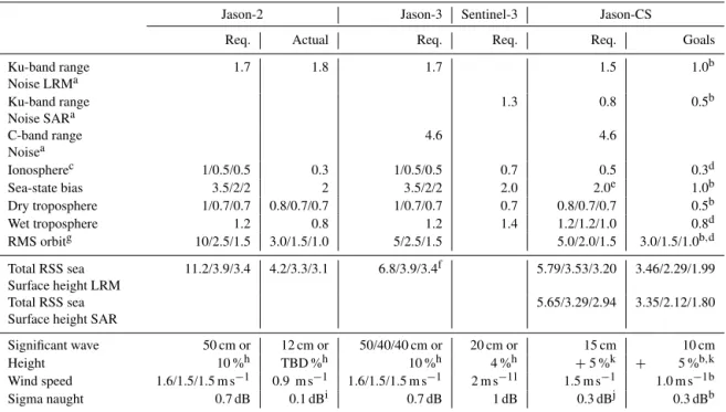
Table 5.Overview of the requirements and actual performances of Jason-2 (NASA, 2011), the requirements for Jason-3 (Couderc, 2015), the requirements for the Sentinel-3 SRAL (Ferreira, 2009; Donlon, 2011) and the requirements and goals for Jason-CS. In each column either a single value is presented if it applies equally to NRT, STC, and NTC. If a triplet of numbers is given, it applies to NRT/STC/NTC. Numbers are in centimetres, unless indicated otherwise.
Jason-2 Jason-3 Sentinel-3 Jason-CS
Req. Actual Req. Req. Req. Goals
Ku-band range Noise LRMa
1.7 1.8 1.7 1.5 1.0b
Ku-band range Noise SARa
1.3 0.8 0.5b
C-band range Noisea
4.6 4.6
Ionospherec 1/0.5/0.5 0.3 1/0.5/0.5 0.7 0.5 0.3d
Sea-state bias 3.5/2/2 2 3.5/2/2 2.0 2.0e 1.0b
Dry troposphere 1/0.7/0.7 0.8/0.7/0.7 1/0.7/0.7 0.7 0.8/0.7/0.7 0.5b
Wet troposphere 1.2 0.8 1.2 1.4 1.2/1.2/1.0 0.8d
RMS orbitg 10/2.5/1.5 3.0/1.5/1.0 5/2.5/1.5 5.0/2.0/1.5 3.0/1.5/1.0b,d
Total RSS sea Surface height LRM
11.2/3.9/3.4 4.2/3.3/3.1 6.8/3.9/3.4f 5.79/3.53/3.20 3.46/2.29/1.99
Total RSS sea Surface height SAR
5.65/3.29/2.94 3.35/2.12/1.80
Significant wave 50 cm or 12 cm or 50/40/40 cm or 20 cm or 15 cm 10 cm
Height 10 %h TBD %h 10 %h 4 %h +5 %k + 5 %b,k
Wind speed 1.6/1.5/1.5 m s−1 0.9 m s−1 1.6/1.5/1.5 m s−1 2 m s−1l 1.5 m s−1 1.0 m s−1b Sigma naught 0.7 dB 0.1 dBi 0.7 dB 1 dB 0.3 dBj 0.3 dBb
aAfter ground processing, averaged over 1 s, for 2 m wave height.bGoals from CNES system performances budget study.cDerived from Ku- and C-band range difference, averaged over 200 km.dJason-2 actual performance (NASA, 2011).eCould also be expressed as 1 % of SWH.fThe RSS values for the NTC products given in (Couderc, 2015) have been corrected.gNRT/OGDR orbit from real-time DORIS on-board ephemeris.hWhichever is greater.iAfter calibration to Jason-1.jAfter cross-calibration with other altimeter missions.kFor 0.5–8 m SWH range.lFor 3–20 m s−1wind speed range.
be quantified and broken down into the individual compo-nents that make up the measurement of sea surface height: altimeter range, orbital altitude, atmospheric corrections, and sea state bias. A thorough analysis was done on the current state of the art of Jason-2, and the requirements currently set for the altimeter missions of Jason-3 and Sentinel-3. All these numbers are gathered in Table 5. One will notice that the Jason-2 requirements (as reported by NASA, 2011) have mostly been copied straight into the Jason-3 requirements (Couderc, 2015), except for the orbit error, which has been adjusted given the intervening improvements in POD. How-ever, other advances in atmospheric modelling were ignored, even though they are evident when we look at the actual Jason-2 performances (NASA, 2011).
A further review of the performance of Jason-2, expected performances of the Poseidon-4 altimeter, and current POD performances led to the establishment of the Jason-CS re-quirements listed in Table 5, with some more challeng-ing goals to be met for all products later in the mission. Overall, the Jason-CS requirements for the RSS sea surface height error for LRM measurements closely meet the estab-lished Jason-2 performances, whereas SAR measurements will clearly outperform Jason-2, because of the reduction in measurement noise. The only exception are the orbit perfor-mances, which are kept conservatively similar to Jason-3
re-quirements. However, the performance goals of orbit deter-mination are likely to be met and are at least equal to Jason-3 performances.
Although the requirements for SWH, wind speed, and backscatter have been kept somewhat less restrictive than the claimed Jason-2 performance, they are still vastly tighter than the requirements for Jason-3 and Sentinel-3, which are re-garded as far too cautious.
7.2 Radio occultation performance
The GNSS-RO will track Global Navigation Satellite Sys-tem (GNSS) signals from the American Global Positioning System (GPS) and the Russian Global Navigation Satellite System (GLONASS). GNSS-RO is a modified receiver as also used for the COSMIC-2 mission (e.g. Kramer, 2015) and tracks signals on the L1 and L2 GNSS frequencies. The POD antenna will only observe GPS signals for orbit pre-diction, while two occultation antennas, facing in satellite velocity and anti-velocity direction, will observe GPS and GLONASS. A potential upgrade to include also the Euro-pean Galileo signals will be investigated once enough Galileo satellites are available.
The GNSS-RO will observe occultations over the straight-line tangent altitude (SLTA) Range from−300 to 500 km,
refer-ence ellipsoid of an imaginary straight line connecting Jason-CS and the occulting GNSS satellite. This is negative in the lower atmosphere since the refraction bends the ray behind the horizon. As a secondary payload, the GNSS-RO will not be able to observe the upper atmosphere up to orbit altitude due to data size limitations.
The occultation tracking rates are 50 for GPS and 100 Hz for GLONASS in the lower atmosphere, while higher up a 1 Hz tracking is foreseen. Open loop tracking is enabled from a configurable SLTA altitude downwards. With no ultra-stable oscillator available, occultation processing will rely on single differencing with respect to a reference GNSS satellite to be tracked simultaneously.
Based on simulations with a constellation of 31 GPS and 24 GLONASS satellites and assuming an antenna coverage of±55◦in azimuth, the Jason-CS satellite will be observing
about 1100 occultations per day, about 600 from GPS and about 500 from GLONASS. Contrary to e.g. the EUMET-SAT Polar System (EPS) and the EPS-Second Generation (EPS-SG), Jason-CS will fly in a non-sun-synchronous orbit, providing measurements at various local solar times, cycling through a full 24 h every 118 days.
8 Summary
The Sentinel-6 mission, consisting of two consecutively fly-ing altimeter satellites, Jason-CS A and Jason-CS B, will en-sure the continuation of the decades-long time series of sea level as recorded by TOPEX/Poseidon, Jason-1, Jason-2, and soon, Jason-3, from 2020 to 2030. Since the radar altimeter will be able to serve simultaneously as a conventional LRM altimeter, and as a SAR altimeter, it not only provides com-patibility with the previous mission that is vital to the accu-rate cross-calibration of Jason-CS and Jason-3 but it will also improve sampling of the coastal areas with a much higher resolution, and providing the ability to measure closer to the coast line.
The Sentinel-6 mission will be the first of the “refer-ence missions” for which not only Level 2 will be provided to users. In fact, the mission will provide a wide range of Level 1, Level 2P, and Level 3 products as well, aiming not only at operational meteorological and oceanographic mod-ellers but also giving altimeter specialist the opportunity to further advance altimeter technologies that will be provided by the unique altimeter flown on the Jason-CS satellites.
Sentinel-6 will also include a secondary radio occultation payload, which makes use of GPS and GLONASS satellites to observe up to about 1100 occultations per day (prior to quality control).
Acknowledgements. The authors thank the wider multi-agency Sentinel-6 project team for providing further detailed information on the proposed system and programme.
Edited by: J. A. Johannessen
References
Couderc, V.: Jason-3 System Requirements, TP4-J0-STB-44-CNES v 1.3, Centre Nationale d’Etudes Spatiales, Toulouse, 2015. Donlon, C.: Sentinel-3 Mission Requirements Traceability
Doc-ument (MRTD), EOP-SM/2184/CD-cd, v1.0, European Space Agency, Noordwijk, the Netherlands, 2011.
Donlon, C., Berruti, B., Buongiorno, A., Ferreira, M.-H., Fémé-nias, P., Frerick, J., Goryl, P., Klein, U., Laur, H., Mavro-cordatos, C., Nieke, J., Rebhan, H., Seitz, B., Stroede, J., and Sciarra, R.: The Global Monitoring for Environment and Secu-rity (GMES) Sentinel-3 mission, Remote Sens. Environ., 120, 37–57, 2012.
Ferreira, M. H.: ESA GMES Sentinel-3 System Requirements Doc-ument, S3-RS-ESA-SY-0010, v4.0, European Space Agency, Noordwijk, the Netherlands, 2009.
Fu, L.-L., Christensen, E. J., Yamarone Jr., C. A., Lefebvre, M., Ménard, Y., Dorrer, M., and Escudier, P.: TOPEX/POSEIDON mission overview, J. Geophys. Res., 99, 24369–24381, doi:10.1029/94JC01761, 1994.
Gommenginger, C. P., Martin-Puig, C., Dinardo, S., Cotton, P. D., and Benveniste, J.: Improved altimetric performance of CryoSat-2 SAR mode over the open ocean and the coastal zone, Presented at the European Geosciences Union General Assembly, Vienna, Austria, 22–27 April 2012, 2012.
Gommenginger, C. P., Martin-Puig, C., Amarouche, L., and Raney, K.: SAR Mode Error Budget Study: Review of State of Knowledge of SAR Altimetry over Ocean, EUMETSAT Ref. EUM/RSP/REP/14/749304, version 2.2, Darmstadt, Germany, 2013.
Halimi, A. and Mailhes, C., Tourneret, J.-Y., Thibaut, P., and Boy, F.: A semi-analytical model for delay/Doppler altimetry and its estimation algorithm, IEEE Trans. Geosci. Rem. Sens., 52, 4248–4258, doi:10.1109/TGRS.2013.2280595, 2014.
Kramer, H. J.: FormoSat-7/COSMIC-2 (Constellation Observing System for Meteorology, Ionosphere and Climate), available at: https://directory.eoportal.org/ (last access: 24 March 2016), 2015.
Lambin, J., Morrow, R., Fu, L.-L., Willis, J. K., Bonekamp, H., Lillibridge, J., Perbos, J., Zaouche, G., Vaze, P., Bannoura, W., Parisot, F., Thouvenot, E., Coutin-Faye, S., Lindstrom, E., and Mignogno, M.: The OSTM/Jason-2 Mission, Marine Geodesy, 33, 4–25, doi:10.1080/01490419.2010.491030, 2010.
Ménard, Y. and Fu, L.-L.: Jason-1 Mission, Jason-1 science plan, AVISO newsletter 8, AVISO altimetry edition, Ramonville St. Agne, France, 2001.
NASA: OSTM End of Prime Mission Report, NASA Headquarters, Washington, DC, USA, 2011.
Science Team 2012, Venice, Italy, 27–28 September 2012, available at: http://www.aviso.oceanobs.com/en/user-corner/ science-teams/ostst-swt-science-team/ostst-2012-venice.html (last access: 24 March 2016), 2012.