www.clim-past.net/9/1417/2013/ doi:10.5194/cp-9-1417-2013
© Author(s) 2013. CC Attribution 3.0 License.
Climate
of the Past
Geoscientiic
Geoscientiic
Geoscientiic
Geoscientiic
Megalake Chad impact on climate and vegetation
during the late Pliocene and the mid-Holocene
C. Contoux1,2, A. Jost2, G. Ramstein1, P. Sepulchre1, G. Krinner3, and M. Schuster4
1Laboratoire des Sciences du Climat et de l’Environnement/IPSL, UMR8212, CEA/CNRS/UVSQ –
Gif-sur-Yvette Cedex, France
2Sisyphe, UPMC Paris 6/CNRS, Paris, France
3Laboratoire de Glaciologie et de G´eophysique de l’Environnement, UJF-Grenoble1/CNRS, Grenoble, France 4Institut de Physique du Globe de Strasbourg, UMR7516, CNRS – Universit´e de Strasbourg/EOST, 1 rue Blessig,
67084 Strasbourg Cedex, France
Correspondence to:C. Contoux ([email protected])
Received: 26 February 2013 – Published in Clim. Past Discuss.: 11 March 2013 Revised: 23 May 2013 – Accepted: 4 June 2013 – Published: 5 July 2013
Abstract.Given the growing evidence for megalakes in the geological record, assessing their impact on climate and veg-etation is important for the validation of palaeoclimate sim-ulations and therefore the accuracy of model–data compari-son in lacustrine environments. Megalake Chad (MLC) oc-currences are documented not only for the mid-Holocene but also for the Mio-Pliocene (Schuster et al., 2009). At this time, the surface covered by water would have reached up to ∼350 000 km2 (Ghienne et al., 2002; Schuster et
al., 2005; Leblanc et al., 2006), making it an important evaporation source, possibly modifying climate and vege-tation in the Chad Basin. We investigated the impact of such a giant continental water area in two different climatic backgrounds within the Paleoclimate Model Intercompari-son Project phase 3 (PMIP3): the late Pliocene (3.3 to 3 Ma, i.e. the mid-Piacenzian warm period) and the mid-Holocene (6 kyr BP). In all simulations including MLC, precipitation is drastically reduced above the lake surface because deep convection is inhibited by overlying colder air. Meanwhile, convective activity is enhanced around MLC because of the wind increase generated by the flat surface of the megalake, transporting colder and moister air towards the eastern shore of the lake. The effect of MLC on precipitation and temper-ature is not sufficient to widely impact vegetation patterns. Nevertheless, tropical savanna is present in the Chad Basin in all climatic configurations, even without MLC presence, showing that the climate itself is the driver of favourable environments for sustainable hominid habitats.
1 Introduction
The Chad Basin is a vast endorheic basin located in north-central Africa, between 5 and 25◦N (Fig. 1), covering
ap-proximately 2.5×10⁶km2. At present, climate is sub-desertic
to tropical humid (Sudanian), with precipitation ranging from 0 to 900 mm yr−1. The wind regime is dominated by the
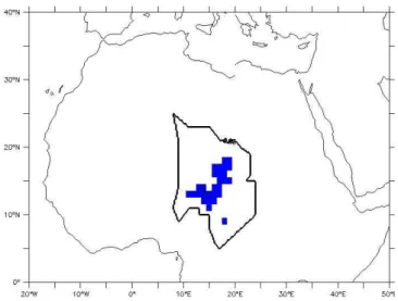
Fig. 1.Imposed lake surface in LMDZ4 for “lake” experiments. The black contour line represents the Chad hydrological basin (catch-ment) limits.
2005, 2009; Drake and Bristow, 2006; Leblanc et al., 2006; Bouchette et al., 2010). At the time, this large water body reached more than 350 000 km2(Ghienne et al., 2002; Schus-ter et al., 2005; Leblanc et al., 2006) with wind-driven hy-drodynamics (Bouchette et al., 2010). Similar MLC episodes are thought to have occurred during the Miocene and the Pliocene (Schuster et al., 2001, 2006; Griffin, 2006), suppos-edly linked to a northward shift of the West African monsoon system. In particular, sediments from the northern part of the Chad Basin describe lacustrine occurrences from 7 to 3 Ma (Schuster et al., 2001, 2006, 2009; Lebatard et al., 2010), as-sociated with the presence of fossil vertebrate fauna and two hominids (Sahelanthropus tchadensis, 7 Ma, Brunet et al., 2002; and Australopithecus bahrelghazali, 3.6 Ma, Brunet et al., 1995), in a mosaic vegetation landscape (Brunet et al., 1997). Climate models for the mid-Holocene (Braconnot et al., 2007) and the Pliocene (Haywood et al., 2013) gen-erally simulate more precipitation in North Africa, allowing drainage system reactivation and large lake development for these periods.
Investigating potential climate and vegetation perturba-tions induced by open continental water surfaces is the sub-ject of many studies (e.g. Coe and Bonan, 1997; Brostr¨om et al., 1998). The impact of the desiccation of pre-industrial Lake Chad (25 000 km2) on climate was investigated by Lauwaet et al. (2012). Using a mesoscale regional at-mospheric model coupled to a soil–vegetation–atmosphere transfer (SVAT) model, they found that total precipitation amounts were hardly affected by the presence of Lake Chad compared to no lake or to a small one (6000 km2). Filled pre-industrial Lake Chad increases precipitation over the lake and its eastern border, but large-scale atmospheric pro-cesses are not affected, and far-field impact is unclear and variable (Lauwaet et al., 2012). MLC impact on climate
has been tested several times with numerical simulations as well, but only in the mid-Holocene or pre-industrial cli-mates. Brostr¨om et al. (1998) used an atmospheric general circulation model (AGCM) to study the impact of vegetation, MLC and wetlands on North African climate during the mid-Holocene, but using present-day sea-surface temperatures (SSTs). They found that vegetation forced the African mon-soon roughly 300 km northward, while MLC and wetlands only produced local changes, with no northward shift of the monsoon. Sepulchre et al. (2009) and Krinner et al. (2012) investigated African climate responses to different surface conditions using the LMDZ4 AGCM including a lake sur-face module (Krinner, 2003). Sepulchre et al. (2009) car-ried out sensitivity tests for the MLC presence in a pre-industrial climate, and found that it had a negative feed-back on the Chad Basin water balance, and that deep con-vection processes were inhibited by the cold water surface of the megalake, preventing precipitation and associated lo-cal water recycling. Krinner et al. (2012), using 9 kyr SSTs previously simulated with an AOGCM, accounting for mid-Holocene lakes (including MLC), wetlands and vegetation feedback all over northern Africa, found a similar negative feedback of MLC over its surface, but suggested that at larger scale, these surface conditions locally more than doubled the simulated precipitation rates outside the Chad Basin, in the dry areas of central and western Sahara.
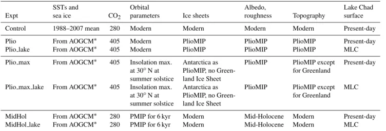
Table 1.Boundary conditions for the simulations.
SSTs and Orbital Albedo, Lake Chad Expt sea ice CO2 parameters Ice sheets roughness Topography surface
Control 1988–2007 mean 280 Modern Modern Modern Modern Present-day
Plio From AOGCM∗ 405 Modern PlioMIP PlioMIP PlioMIP Present-day
Plio lake From AOGCM∗ 405 Modern PlioMIP PlioMIP PlioMIP MLC
Plio max From AOGCM∗ 405 Insolation max. Antarctica as PlioMIP PlioMIP except Present-day
at 30◦N at PlioMIP, no Green- for Greenland
summer solstice land Ice Sheet
Plio max lake From AOGCM∗ 405 Insolation max. Antarctica as PlioMIP PlioMIP except MLC
at 30◦N at PlioMIP, no Green- for Greenland
summer solstice land Ice Sheet
MidHol From AOGCM∗ 280 PMIP for 6 kyr Modern Mid-Holocene Modern Present-day
MidHol lake From AOGCM∗ 280 PMIP for 6 kyr Modern Mid-Holocene Modern MLC
SSTs specified with a∗are implemented as anomalies.
conditions and an orbital configuration with perihelion in summer, corresponding to the maximum of insolation at 30◦N between 3.3 to 3 Ma. These climate simulations will
help clarify the feedback role of MLC on climate by test-ing this impact in a new climatic context, the late Pliocene. The simulated climates are then used to force the vegetation model BIOME4 (Kaplan et al., 2003), which is widely used to simulate palaeovegetation with GCM outputs (e.g. Har-rison and Prentice, 2003) and accounts for CO2
concentra-tion variaconcentra-tions. This study investigates the local and regional feedbacks of MLC on climate and vegetation in different cli-matic backgrounds and orbital configurations for which re-sults are compared in order to exhibit common robust tures and, if possible, background climate-dependent fea-tures. In this respect, it is the first time that MLC impact has been investigated in the late-Pliocene climate.
2 Models description
2.1 LMDZ4 LAKE atmospheric model
We use the LMDZ4 atmospheric general circulation model (AGCM) (Hourdin et al., 2006) including a water surface module (Krinner, 2003) composed of eight layers, which represent the thermal and hydrological processes occurring above and beneath the continental water surface. The model explicitly represents the penetration and absorption of sun-light into the lake levels, as well as heat conduction, con-vective overturning, water phase changes, sensible and la-tent turbulent surface heat fluxes and water balance (Krinner, 2003). Lake surface is fixed and is an additional surface type to the LMDZ4 scheme already including ocean, sea ice, land ice and land. In this study, vegetation is prescribed through albedo and roughness boundary conditions, and the surface scheme is a bucket model. Although water balance of the lake
is calculated, the absence of a surface water routing scheme makes it inappropriate to use the model for prediction of lake level and extent. This model can then only be used as a pre-dictor of lake impact on climate. Resolution is zoomed to
∼100 km for the Lake Chad region, and mean grid
spac-ing is 3.75◦
×2.5◦. The atmosphere has 19 vertical layers.
Parameterization of convection is the Emanuel scheme (see Hourdin et al., 2006). Previous studies used this model to in-vestigate the climatic impact of MLC in a pre-industrial con-text (Sepulchre et al., 2009) and during the mid-Holocene (Krinner et al., 2012).
2.2 BIOME4 vegetation model
BIOME4 is an equilibrium biogeography model developed by Kaplan et al. (2003) which is based on BIOME3 (Hax-eltine and Prentice, 1996). It is widely used for the simula-tion of equilibrium vegetasimula-tion in past climates, including the pre-Quaternary climates of the Tortonian (Pound et al., 2011) and Piacenzian (Salzmann et al., 2008; Kamae and Ueda, 2012) and the more recent mid-Holocene (Kaplan et al., 2003; Krinner et al., 2012). This model simulates the equilib-rium distribution of 28 biomes. This potential natural vegeta-tion is determined by the ranking of 12 plant funcvegeta-tional types (PFTs) which have different bioclimatic limits (temperature resistance, moisture requirement, sunshine amount). Compe-tition between the PFTs is a function of net primary produc-tivity (NPP) and uses an optimization algorithm to calculate the maximum sustainable leaf area index (LAI). NPP, LAI and mean annual soil moisture are then classified empirically to determine the predominant biome (Haxeltine and Prentice, 2003). Input data of the model include the mean monthly climate (temperature, precipitation, sunshine and minimum temperature), soil physical properties and atmospheric CO2
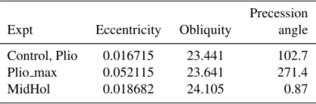
Table 2.Orbital parameters used for the different experiments.
Precession Expt Eccentricity Obliquity angle
Control, Plio 0.016715 23.441 102.7 Plio max 0.052115 23.641 271.4 MidHol 0.018682 24.105 0.87
3 Experimental design and boundary conditions
3.1 AGCM experiments
Three climatic configurations are investigated: two are late-Pliocene (mPWP) experiments (Plio and Plio max simu-lations) and one is mid-Holocene (6 kyr, MidHol simula-tions). The two late-Pliocene experiments differ by the im-posed SSTs and orbital configuration, which are described in Sect. 3.1.2. For each simulation, integration time is 70 yr, and climatologies are performed on the last 50 yr. To study the impact of the lake on these past climates, we carry out two simulations for each climatic configuration (except the control): one with imposed MLC surface (Fig. 1, “lake” sim-ulations), the other one with a single grid point defined as a lake surface, which roughly corresponds to present-day Lake Chad. In order to be the closest possible to the to-pographic reconstruction of MLC extent from Schuster et al. (2005), we ran the HYDRA routing surface model (Coe, 2000) with direct outputs of the standard PlioMIP Pliocene coupled model simulation, which completely fills MLC and then outflows into the Benue river, providing the maximum extent of MLC. The simulated extent and shape were then regridded to 1◦×1◦ resolution, and define MLC surface
boundary condition as shown in Fig. 1. Lake depth is fixed to 20 m at the beginning of the simulation. In total, six cli-matic simulations plus the control run were carried out. All these simulated climate anomalies are then used to force the BIOME4 vegetation model. A summary of the bound-ary conditions for each simulation can be found in Table 1. Orbital parameters for each simulation can be found in Ta-ble 2. For the mid-Holocene at 6 kyr, they are defined follow-ing the PMIP3 protocol. For Plio simulations, they are set to pre-industrial values. For Plio max simulations, they corre-spond to the maximum of insolation of the PlioMIP interval at 30◦N at summer solstice.
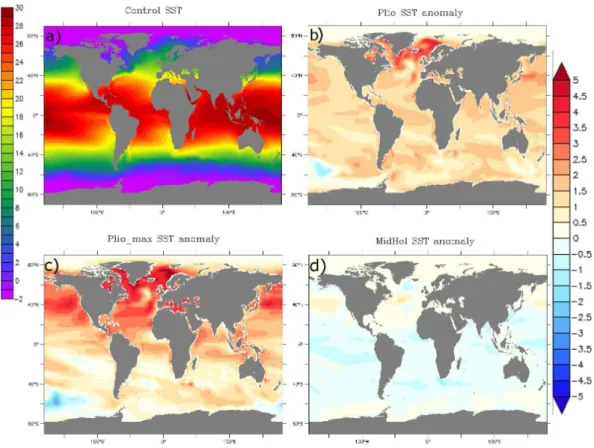
3.1.1 Control 0 kyr simulation
For the control simulation, boundary conditions (i.e. albedo, roughness, topography and ice sheets) are set to modern. Im-posed SSTs are the climatological mean value for 1988–2007 from the AMIP 2 dataset (Fig. 2a). Greenhouse gases, so-lar constant and orbital parameters are set to pre-industrial values as required by CMIP5/PMIP3; that is, solar constant
is 1365 W m−2, CO
2 content is 280 ppm, CH4 content is
760 ppb and N2O content is 270 ppb.
3.1.2 Pliocene experiments
For Pliocene experiments, we investigated two different cli-matic configurations. First, the standard late-Pliocene (mid-Piacenzian) simulations, called Plio, have anomalies of SSTs and sea-ice cover calculated with the IPSL-CM5A AOGCM in the PMIP3/PlioMIP framework (Fig. 2b). This AOGCM simulation is described in detail in Contoux et al. (2012) and corresponds to PlioMIP Experiment 2 (Haywood et al., 2011). Because the precession parameter varies during the late-Pliocene time slab of 300 kyr, and can favour a more northerly position of the ITCZ (e.g. deMenocal, 2004), we investigated a second climatic configuration called Plio max. SST anomalies for this simulation are calculated with the IPSL-CM5A model, starting from a previous Pliocene run, changing the orbital configuration to the maximum of in-solation during summer solstice at 30◦N between 3.3 and
3 Ma (Table 2), based on Laskar et al. (2004). The maxi-mum of insolation at 30◦N is simultaneous to the maximum
of insolation at 65◦N and occurs at 3.039 Ma. This is very
similar to the Plio NHmax configuration used in Dolan et al. (2011). The calculated SSTs are then imposed as anoma-lies in the LMDZ4 simulation (Fig. 2c), which is also forced with this orbital configuration (Tables 1 and 2). This insola-tion forcing globally warms the Northern Hemisphere SSTs and cools the Southern Hemisphere SSTs compared to the Plio simulations. Temperatures in the Gulf of Guinea are cooler than in the Plio simulation. All Pliocene SSTs show an important warming in the North Atlantic and a moder-ate warming in the Gulf of Guinea (from 1 to 2.5◦C), an
area possibly impacting moisture amount in the Chad region (e.g. Sepulchre et al., 2009). Pliocene SST anomalies (Plio experiment only) in the eastern Atlantic compares well with some ODP sites data (Dowsett et al., 2013). For example, site ODP 659, situated off the coast of Mauritania at 18◦N, shows
a warm anomaly of 2.26◦C, while the simulated anomaly
with IPSL-CM5A is 2.3◦C. Site ODP 958, situated more
northerly at 23◦N, compares also well with modelled SST,
with a warming anomaly of 2.29◦C compared to modelled
2.03◦C. Other sites of the eastern tropical Atlantic (ODP
667 and 661 and DSDP 366, between 4 and 10◦N) show no
change or a warming of maximum 1◦C, whereas the model
simulates between 1.5 and 1.8◦C of warming (Dowsett et
al., 2013). For the North Atlantic, model SST anomalies are several degrees colder than SST estimates from Dowsett et al. (2010), but this is a general feature of all models in the PlioMIP (Dowsett et al., 2013). For all Pliocene experiments, albedo and roughness are calculated from the mid-Piacenzian biome vegetation dataset of Salzmann et al. (2008). The main features of this vegetation reconstruction are the reduction of deserts and the northward shift of temperate biomes. CO2
Fig. 2.SSTs imposed in LMDZ4 for(a)control(b)Plio,(c)Plio max and(d)MidHol experiments,(b-d)expressed as difference from the control SSTs (1988–2007 mean), in◦C.
mid-Pliocene; that is, the Greenland Ice Sheet is reduced by roughly 50 % and Antarctica by roughly 33 % (Hill et al., 2007; Hill, 2009), except for Plio max experiments, where the Greenland Ice Sheet was removed, following the conclu-sions of Dolan et al. (2011). Anomalous mid-Pliocene to-pography is prescribed (Edwards, 1992; Sohl et al., 2009) following the guidelines of PlioMIP (Haywood et al., 2010), except for Plio max experiments. For this last experiment, ice-free Greenland topography is calculated with the Grisli ice-sheet model (Ritz et al., 2001) in order to take into ac-count isostatic rebound, and Pliocene anomalous topography is used everywhere else.
3.1.3 Mid-Holocene experiments
For the mid-Holocene experiments (MidHol and Mid-Hol lake), orbital configuration is as stated in PMIP3 for the mid-Holocene (Table 2). CO2 and ice sheets are
pre-industrial, following the PMIP3 protocol. A first simula-tion with LMDZ4 was carried out with the control veg-etation, from which climatic variables were used to cal-culate a vegetation distribution for the mid-Holocene with the BIOME4 model. The resulting vegetation, in which the Sahara is smaller than at present, is used to calcu-late albedo and roughness for the mid-Holocene
simula-tions. We use anomalies of SSTs and sea-ice cover calcu-lated with the IPSL-CM5A AOGCM, in the PMIP3 frame-work (Fig. 2d). This AOGCM simulation is described in Kageyama et al. (2013). Contrary to Pliocene SSTs, Mid-Hol SSTs show a decrease in temperature of about 0.5 to 1◦C in the Gulf of Guinea. In order to assess the quality
of these simulated SSTs, we use the GHOST database from Leduc et al. (2010) to do a model–data comparison of SST anomalies at 6 kyr BP. We take the difference between the value for 6 kyr BP and the core top to calculate anomalies (as in Hargreaves et al., 2013). Since alkenones and Mg/Ca show opposite trends throughout the Holocene for the Gulf of Guinea and some North Atlantic sites, we decided to use only alkenone data, despite the fact that high-latitude alkenone SST records could be biased towards summer month tem-peratures (Leduc et al., 2010; Prahl et al., 2010). For the Gulf of Guinea, alkenone-derived SSTs describe colder con-ditions at 6 kyr BP (−1.9◦C) which are reproduced by the
model, although not to the right amplitude (only −0.44◦C
for the modelled SST anomaly). Off the coast of Mauritania, at 19◦N, the modelled anomaly (+0.34◦C) correctly
repro-duces the warmer conditions seen in the data (+0.5◦C),
al-though slightly more in the south at 18.6◦N, warmer
condi-tions are depicted in the data (+0.8◦C), whereas the model
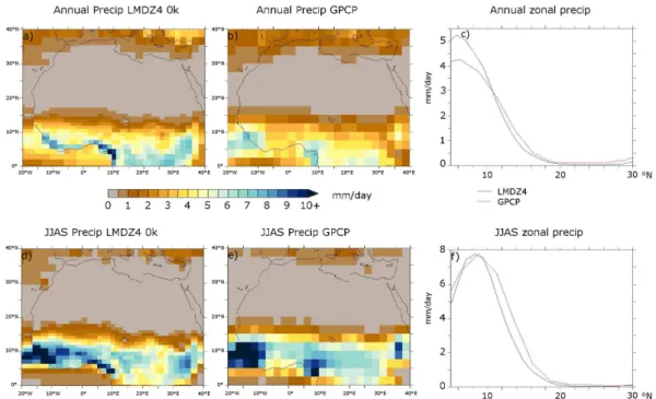
Fig. 3.Top: comparison of annual mean precipitation between the control run (left) and GPCP mean precipitation for years 1979–2010 (centre). Bottom: same for June to September mean precipitation.
only two data points are available in the alkenone database, and the one north of Iceland falls on one model land grid point. The last point is located south of Iceland, at 58.76◦N,
and depicts a warm anomaly of 0.2◦C. The modelled SST
anomaly is negative on the annual average (−0.61◦C), but
with warm anomalies occurring in July (+0.07◦C), August
(+0.8◦C) and September (0.18◦C), i.e. in summer.
3.2 BIOME4 simulations
Monthly mean temperature, precipitation, sunshine and an-nual minimum temperature anomalies of the control run were computed from the last 50 yr of each climate simulation and were added to the modern climatology from Leemans and Cramer (1991). This anomaly procedure is widely used (e.g. Kaplan et al., 2003; Haywood et al., 2009) and helps to reduce the climate model simulations’ biases. Soil texture and water-holding capacity were unchanged compared to the present. CO2 is specified to 405 ppm for all the Pliocene
experiments, and to 280 ppm for the mid-Holocene experi-ments. BIOME4 is run on a 0.5◦
×0.5◦grid.
4 Results
4.1 North African rainfall in the control run
Annual mean and June to September precipitation over North Africa simulated for the control run are compared to the GPCP Version 2.2 dataset (Adler et al., 2003; Huffman et al., 2009) in Fig. 3. The model overestimates annual mean
pre-cipitation in the equatorial zone (from 0 to 7◦N), but well
represents the transition from Sudanian to desertic zones (from 10◦N to the Sahara), although with a slight
under-estimation. Regarding monsoon precipitation, the model is in good agreement with GPCP data on the equatorial zone, but from 10 to 25◦N, precipitation is also slightly
under-estimated, particularly from 12 to 16◦N (−1 mm day−1). It
means that for the Sahelian zone, the annual amount of precipitation is correctly represented but is too widely dis-tributed throughout the year. Summer precipitation response to a given perturbation might thus be slightly underestimated in the model.
4.2 North African rainfall in the late Pliocene and mid-Holocene
First, all simulations are more humid than the control be-tween 10 and 20◦N (Fig. 4). Plio configuration is generally
more humid than the control, except between 30 and 40◦N
(Fig. 4, red line). Plio max configuration is characterized by a much broader ITCZ, hence reduced precipitation in the equatorial zone between 3 and 12◦, but much wetter
trop-ics and subtroptrop-ics from 12 to 30◦N (Fig. 4, blue line)
com-pared to the control run. MidHol simulation is more humid than the control, except slightly drier from 6 to 9◦N. MidHol
simulation is also more humid than Plio from 10 to 20◦N.
Fig. 4.Mean annual precipitation simulated with LMDZ4 in func-tion of latitude, averaged over 20◦W to 40◦E.
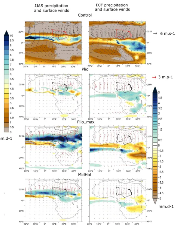
During summer months, in Plio simulation, there is an increase in precipitation over the eastern part of the Chad Basin, and over central Africa compared to the control run. In Plio max simulation, the summer monsoon over West Africa is shifted several degrees northward, while over cen-tral and eastern Africa, precipitation increases particularly between 15 and 22◦N. Precipitation is increased by more
than 5 mm d−1 over the central-eastern part of the Chad
Basin. In the MidHol simulation, patterns are similar to Plio max, but with lesser intensity (up to +2.5 mm d−1 in
the Chad Basin). The West African summer monsoon is shifted several degrees northward, with local increases up to 3.5 mm d−1over West Africa. Summer precipitation also
in-creases in the eastern part of the Chad Basin up to 2 mm d−1.
Concerning the winter monsoon (Fig. 5, right), precipitation increases in the Plio simulation. In contrast, in Plio max and MidHol simulations, the precipitation front is narrower and shifted southward, though with lesser intensity in the Mid-Hol simulation. A common feature of these simulations is the northward shift of the ITCZ during summer months com-pared to the control run, controlled by the reduced latitudi-nal temperature gradient in the Northern Hemisphere (Davis and Brewer, 2009), with increased southwesterlies over cen-tral to eastern parts of the Sahara (Fig. 5, left). Similarly to the present, precipitation falls on the Chad Basin only during summer months. Increased precipitation over the Chad Basin in all the simulations agree with the possibility of MLC be-ing present in the basin. We will now investigate the impact of such a water surface area on climate and vegetation in or-der to unor-derstand its role in the development of sustainable conditions for hominid presence.
4.3 MLC impact on climate
First, the presence of MLC does not impact zonal-average precipitation over the northern part of the African continent (Fig. 4). In all simulations there is no northward shift of the precipitation front induced by the presence of MLC. Over the Chad Basin, the wind regime varies throughout the year, and precipitation only falls during the monsoon season un-der southwesterly winds conditions. During the rest of the year (October to May), the precipitation front does not reach MLC, and the presence of the megalake does not generate any precipitation. Considering this aspect, we restrict our analysis to summer months means, which display the same patterns as annual means. Regarding the spatial distribution of precipitation (Fig. 6), the most striking impact of MLC is a reduction of precipitation above the surface of the lake in the three climatic configurations (from−1 to−5 mm d−1).
This is consistent with previous studies (Sepulchre et al., 2009; Krinner et al., 2012) and is well explained by the fol-lowing: since the lake is generally colder than the surround-ing environment, low-level air becomes cooler and denser (Fig. 7) and stabilizes the atmosphere, preventing deep con-vection and associated rainfall. This mechanism is observed in both Pliocene simulations and in the mid-Holocene one, suggesting it is a robust feature appearing in different back-ground climates. In the meantime, convective activity in-creases around MLC, especially to the east. Southwesterly winds are enhanced above the surface of the lake due to the reduced roughness length over the flat surface (Figs. 6 and 8), generating convective activity at the northeast of MLC, in the three simulations. Similarly, the effect of pre-industrial Lake Chad on climate is to increase convective activity downwind of the lake (Lauwaet et al., 2012). Moreover, MLC, espe-cially its northern part, is a centre of higher pressure (Fig. 7), generating clockwise winds that can be seen in Fig. 7, which are responsible for the increase of precipitation in the south-east of the lake in the three simulations (Fig. 6). Significant precipitation response outside the Chad Basin is variable in the three simulations and generally not above 0.5 mm d−1.
This result is different from that of Krinner et al. (2012), in which an increase in precipitation due to MLC and wet-lands is depicted on the zonal average, especially from 15 to 25◦N. The differences between the two studies and the
possible reasons for divergent results are discussed in the Discussion section.
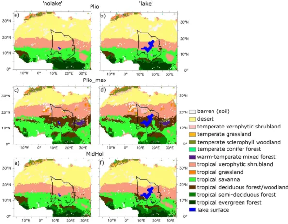
4.4 Biome distribution during the Pliocene and the mid-Holocene
Fig. 5.Left: JJAS precipitation and mean low-level winds, anomalies to the control run. Right: the same for DJF.
shrubland up to 20◦N, which is comparable to the
Mid-Hol simulated vegetation (Fig. 9e and f). Plio max displays a drastic reduction of the Sahara to the benefit of xerophytic shrubland, which reaches from 23◦N on the western coast to
27◦N on the eastern coast of Africa. Tropical woodland also
covers an important area of central to eastern Africa between 11 and 17◦N. An
∼1◦ northward shift of tropical savanna
and a small patch of tropical deciduous forest/woodland ap-pear at the east of MLC in the Plio lake simulation (Fig. 9b). For Plio max simulations, a narrow band of tropical
Fig. 6.JJAS precipitation and 10 m winds difference between “lake” experiments and standard experiment for each climatic configura-tion. Difference is significant at 95 % in a Student’sttest.
to reproduce savanna biomes up to 20◦N, as suggested by
vegetation reconstructions (Hoelzmann et al., 1998). This discrepancy is also seen in the MIROC model (e.g. Ohgaito et al., 2012). Changes induced by MLC consist in the appear-ance of tropical woodland in the southwest of MLC (Fig. 9f).
Fig. 7.JJAS surface temperature and sea level pressure (slp) differ-ence between “lake” experiment and standard experiment for each climatic configuration. Temperature difference is significant at 95 % in a Student’sttest. Sea level pressure difference is expressed in Pa. Isolines every 50 Pa.
5 Discussion
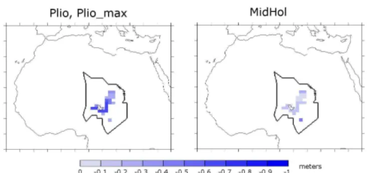
Fig. 8. Roughness length (m) difference between “lake” and standard experiments.The differences between mid-Holocene and Pliocene are due to different lake free vegetation distributions.
Koll´e sites are attributed to ephemeral floods (Schuster, 2002). In a Pliocene context with present-day orbital pa-rameters, the precipitation front reaches the Ennedi plateau, but total rainfall amount remains small (250 mm yr−1). In
Plio max configurations, however, there is important precipi-tation over the Ennedi (600 mm yr−1), even though MLC has
a negative impact over precipitation in this area. The pres-ence of MLC, which increases precipitation in the valley down the Ennedi (Fig. 6b), could have increased the outflow of these potential palaeorivers near their outlet into the lake. For the mid-Holocene, mean precipitation over the Ennedi is small (less than 200 mm yr−1). In any configuration,
precipi-tation over the Ennedi is restricted to summer months. Simu-lations also show that during the Pliocene and mid-Holocene, wind regime throughout the year is comparable to today, only with increased monsoon winds in summer. MLC amplifies this effect because of its flat surface, helping southwesterly winds to reach the northern shore of MLC. Similarly in win-ter, the Harmattan is increased over the lake surface.
The results presented above, showing a weak impact of surface conditions on North African climate, are in agree-ment with several studies (Coe and Bonan, 1997; Brostr¨om et al., 1998; Sepulchre et al., 2009). However, a recent study by Krinner et al. (2012, hereafter K12) described important regional-scale feedbacks of lakes and wetlands on the North African climate during the mid-Holocene, particularly by in-creasing precipitation and reducing droughts over a large part of North Africa. The K12 study uses the LMDZ4 model coupled to the land surface model ORCHIDEE with Hoelz-mann et al. (1998) water surface conditions, which include MLC and some wetlands. The K12 study also has a differ-ent boundary layer parameterization compared to our study, which leads to better reproduction of observed precipitation in the Sahel region for the control run (see Krinner et al., 2012, Fig. 1). Tests carried out with our configuration but with the Hoelzmann et al. (1998) water surface conditions lead to inhibition of deep convection over MLC and wet-lands, and weak redistribution of precipitation with no
sig-nificant increase over the latitudinal average, suggesting the surface boundary condition is not the driver of the differences between the two studies. Although other relatively minor dif-ferences exist in the setup of K12 compared to this study, it seems the key factor triggering the higher sensitivity of the model to the presence of surface water in K12 study is the different boundary layer parameterization, which leads to more convection. The remote effect of surface waters in North Africa might thus be underestimated in state-of-the-art climate models which have good skill on the global scale but which are not tuned to properly represent a given re-gion. In our simulations, the megalake feedback is similar in the three climatic contexts; small biome changes outside the Chad Basin are only noticeable in the Plio max configu-ration. This suggests a wider impact of MLC in a more hu-mid background climate, the threshold to trigger a remote impact of MLC being harder to attain in our simulations than in K12 because of a standard parameterization of the bound-ary layer. Nevertheless, a robust feature is the reduction of deep convection because of colder surface, and redistribu-tion of moisture in the north and east via increased surface winds and anticyclonic circulation. These mechanisms prob-ably take place whenever a megalake is present in a warm climate. Remote impact of MLC alone or with extended wet-land area is mostly not simulated in these studies, but the response of climate to this forcing is dependent on boundary layer parameterization, and may also be dependent on con-vection parameterization (Chikira et al., 2006).
Regarding biome distribution during the Pliocene, tropical savanna is present on the eastern shore of the lake, even in the Plio lake configuration, i.e. with present-day orbital configu-ration, which is close to a glacial one in terms of precession angle, providing a habitable area for hominids during periods of relative droughts during the Pliocene. However, the pres-ence of tropical savanna in this area is neither induced nor significantly favoured by MLC, and the presence of tropical savanna and more humid biomes in this area seems governed by global climate changes. Moreover, the extent of the Sahara seems to greatly vary throughout the Pliocene, depending on precession. With present-day orbital parameters, its south-ern limit is around 20◦N, whereas in the Plio max
configu-ration, it shifts up to 5◦northward, with tropical woodland
reaching 18◦N.
6 Conclusions
Fig. 9.Left: biome distribution for standard experiments. Right: the same for “lake” experiments.
of MLC. During the dry season, the presence of MLC does not generate precipitation over the basin. These results are a common feature of all the simulations. Impact away from the Chad Basin is weak, variable and dependent on boundary layer parameterization. We conclude that while MLC should be taken into account for its influence on climate in the Chad Basin, its influence alone outside the basin is still to be deter-mined, and could be dependent on the background climate. In our study, the presence of MLC does not enhance a north-ward migration of the monsoon, in agreement with Brostr¨om et al. (1998). Regarding vegetation distribution, the presence of MLC has little effect on biomes, although humid biomes are simulated in the Chad Basin in all simulations, providing a sustainable environment for hominid populations, even if restricted to the southern part of the basin in the Plio sim-ulation. The fact that environment was favourable for ho-minids during the late Pliocene but that MLC was not a ma-jor contribution to these conditions reinforces the hypoth-esis that climate change is the driver for these conditions, rather than surface hydrology changes. Other megalakes in present-day dry climates are documented for the Quaternary, such as megalakes Frome and Eyre in Australia (e.g. Al-ley 1998; Cohen et al., 2011), megalake Makgadikgadi in the Kalahari (Burrough et al., 2009) and Darfur megalake in Sudan (Gonheim and El-Baz, 2007), highlighting the
im-portance of studying the impact of such water surfaces on the relatively arid present-day climates of these areas, which can be affected by the northward or southward migration of the monsoon.
Acknowledgements. CC would like to thank Yann Meurdesoif for providing a parallelized version of the model, Pascale Braconnot and Masa Kageyama for providing mid-Holocene SSTs and for fruitful discussions, and Guillaume Leduc for discussion on mid-Holocene data. We thank the reviewers Dan Hill and Aidan Farrow, who provided useful comments. This work was performed using HPC resources from GENCI – [CCRT/TGCC/CINES/IDRIS] (Grant 2012-GEN2212).
Edited by: C. Brierley
References
Adler, R. F., Huffman, G. J., Chang, A., Ferraro, R., Xie, P., Janowiak, J., Rudolf, B., Schneider, U., Curtis, S., Bolvin, D., Gruber, A., Susskind, J., Arkin, P., and Nelkin; E.: The version 2 Global Precipitation Climatology Project (GPCP) monthly pre-cipitation analysis (1979–present), J. Hydrometeorol., 4, 1147– 1167, 2003.
Alley, N. F.: Cainozoic stratigraphy, palaeoenvironments and geo-logical evolution of the Lake Eyre Basin, Palaeogeogr. Palaeocl., 144, 239–263, 1998.
Bouchette, F., Schuster, M., Ghienne, J.-F., Denamiel, C., Roquin, C., Moussa A., Marsaleix, P., and Duringer, P.: Hydrody-namics in Holocene lake Mega-Chad, Quaternary Res., 73, 226– 236, 2010.
Braconnot, P., Otto-Bliesner, B., Harrison, S., Joussaume, S., Pe-terchmitt, J.-Y., Abe-Ouchi, A., Crucifix, M., Driesschaert, E., Fichefet, Th., Hewitt, C. D., Kageyama, M., Kitoh, A., Laˆın´e, A., Loutre, M.-F., Marti, O., Merkel, U., Ramstein, G., Valdes, P., Weber, S. L., Yu, Y., and Zhao, Y.: Results of PMIP2 coupled simulations of the Mid-Holocene and Last Glacial Maximum – Part 1: experiments and large-scale features, Clim. Past, 3, 261– 277, doi:10.5194/cp-3-261-2007, 2007.
Brostr¨om, A., Coe, M., Harrison, S. P., Gallimore, R., Kutzbach, J. E., Foley, J., Prentice, I. C., and Behling, P.: Land surface feedbacks and palaeomonsoons in northern Africa, Geophys. Res. Lett., 25, 3615–3618, 1998.
Brunet, M., Beauvilain, A., Coppens, Y., Heintz, E., Moutaye, A. H. E., and Pilbeam, D.: The first australop-ithecine 2500 km west of the Rift Valley (Chad), Nature, 378, 273–275, 1995.
Brunet, M., Beauvilain, A., Geraads, D., Guy, F., Kasser, M., Mack-aye, H. T., MacLatchy, L. M., Mouchelin, G., Sudre, J., and Vi-gnaud, P.: Chad: a new Pliocene Hominids site, C. R. Acad. Sci. Paris, 324, 341–345, 1997.
Brunet, M., Guy, F., Pilbeam, D., Mackaye, H. T., Likius, A., Ahounta, D., Beauvilain, A., Blondel, C., Bocherens, H,. Bois-serie, J. R., de Bonis, L., Coppens, Y., Dejax, J., Denys, C., Duringer, P., Eisenmann, V., Fanone, G., Fronty, P., Geraads, D., Lehmann, T., Lihoreau, F., Louchart, A., Mahamat, A., Mer-ceron, G., Mouchelin, G., Otero, O., Campomanes, P., Ponce de Leon, M., Rage, J. C., Sapanet, M., Schuster, M., Sudre, J., Tassy, P., Valentin, X., Vignaud, P., Viriot, L., Zazzo, A., and Zollikofer, C.: A new hominid from the Upper Miocene of Chad, Central Africa, Nature, 418, 145–151, 2002.
Burrough, S. L., Thomas, D. S. G., and Singarayer, J. S.: Late qua-ternary hydrological dynamics in the Middle Kalahari: forcing and feedbacks, Earth Sci. Rev., 96, 313–326, 2009.
Chikira, M., Abe-Ouchi, A., and Sumi, A.: General circulation model study on the green Sahara during the mid-Holocene: an impact of convection originating above boundary layer, J. Geo-phys. Res., 111, D21103, doi:10.1029/2005JD006398, 2006. Coe, M. T.: Modeling terrestrial hydrological systems at the
con-tinental scale: testing the accuracy of an atmospheric GCM, J. Climate, 13, 686–704, 2000.
Coe, M. T. and Bonan, G. B.: Feedbacks between climate and sur-face water in northern Africa during the middle Holocene, J. Geophys. Res., 102, 11087–11101, doi:10.1029/97JD00343, 1997.
Cohen, T. J., Nanson, G. C., Jansen, J. D., Jones, B. G., Ja-cobs, Z., Treble, P., Price, D. M., May, J.-H., Smith, A. M., Ayliffe, L. K., and Hellstrom, J. C.: Continental aridification and the vanishing of Australia’s megalakes, Geology, 39, 167–170, doi:10.1130/G31518.1, 2011.
Contoux, C., Ramstein, G., and Jost, A.: Modelling the mid-Pliocene Warm Period climate with the IPSL coupled model and its atmospheric component LMDZ5A, Geosci. Model Dev., 5, 903–917, doi:10.5194/gmd-5-903-2012, 2012.
Davis, B. A. S. and Brewer, S.: Orbital forcing and role of the lati-tudinal insolation/temperature gradient, Clim. Dynam., 32, 143– 165, doi:10.1007/s00382-008-0480-9, 2009.
deMenocal, P. B.: Plio-Pleistocene African climate, Science, 270, 53–59, 1995.
deMenocal, P. B.: African climate change and faunal evolution dur-ing the Pliocene-Pleistocene, Earth Planet. Sc. Lett., 220, 3–24, 2004.
Dolan, A. M., Haywood, A. M., Hill, D. J., Dowsett, H. J., Hunter, S. J., Lunt, D. J., and Pickering, S.: Sensitivity of Pliocene ice sheets to orbital forcing, Palaeogeogr. Palaeocl., 309, 98–110, 2011.
Dowsett, H. J., Robinson, M. M., Stoll, D. K., and Foley, K. M.: Mid-Piacenzian mean annual sea surface temperature analysis for data-model comparisons, Stratigraphy, 7, 189–198, 2010. Dowsett, H. J., Foley, K. M., Stoll, D. K., Bentsen, M.,
Otto-Bliesner, B. L., Bragg, F. J., Chan, W.-L., Chandler, M. A. Con-toux, C., Dolan, A., Haywood, A., Jonas, J. A., Jost, A., Kamae, Y., Lohmann, G., Lunt, D. J., Nisancioglu, K. H., Abe-Ouchi, A., Ramstein, G., Riesselman, C. R., Robinson, M. M., Rosen-bloom, N. A., Salzmann, U., Sohl, L., Stepanek, C., Strother, S. S., Ueda, H., Ying, Q. and Zhang, Z.: Sea surface temperature of the mid-Piacenzian ocean: a data-model comparison. Nature Scientific Reports, 3, 2013, doi:10.1038/srep02013, 2013. Drake, N. and Bristow, C.: Shorelines in the Sahara:
geomor-phological evidence for an enhanced Monsoon from palaeolake Megachad, Holocene, 16, 901–911, 2006.
Edwards, M.: Global Gridded Elevation and Bathymetry, in: Global Ecosystems Database, Version 1.0 (on CD-ROM), Documenta-tion Manual, Disc-A: NaDocumenta-tional Geophysical Data Center, Key to Geophysical Records Documentation No. 26 (Incorporated in: Global Change Database, Volume 1), edited by: Kineman, J. J. and Ohrenschall, M. A., Boulder, CO, National Oceanic and At-mospheric Administration, A14-1–A14-4, 1992
Ghienne, J. F., Schuster, M., Bernard, A., Duringer, P., and Brunet, M.: The Holocene giant lake revealed by digital eleva-tion models, Quaternary Int., 87, 81–85, 2002.
Ghoneim, E. and El-Baz, F.: DEM optical radar data integration for palaeohydrological mapping in the northern Darfur Sudan: implication for groundwater exploration, Int. J. Remote Sens., 28, 5001–5018, 2007.
Griffin, D. L.: The late Neogene Sahabi rivers of the Sahara and their climatic and environmental implications for the Chad Basin, J. Geol. Soc. Lond., 163, 905–921, 2006.
Hargreaves, J. C., Annan, J. D., Ohgaito, R., Paul, A., and Abe-Ouchi, A.: Skill and reliability of climate model ensembles at the Last Glacial Maximum and mid-Holocene, Clim. Past, 9, 811– 823, doi:10.5194/cp-9-811-2013, 2013.
Harrison, S. P. and Prentice, C. I.: Climate and CO2 controls
on global vegetation distribution at the last glacial maximum: analysis based on palaeovegetation data, biome modelling and palaeoclimate simulations, Global Change Biol., 9, 983–1004, doi:10.1046/j.1365-2486.2003.00640.x, 2003.
Haxeltine, A. and Prentice, I.: BIOME3: an equilibrium terres-trial biosphere model based on ecophysiological constraints, resource availability, and competition among plant functional types, Global Biogeochem. Cy., 10, 693–709, 1996.
Haywood, A. M., Chandler, M. A., Valdes, P. J., and Salzmann, U.: Comparison of mid-Pliocene climate predictions produced by the HadAM3 and GCMAM3 general circulation models, Global Planet. Change, 66, 208–224, 2009.
Haywood, A. M., Dowsett, H. J., Otto-Bliesner, B., Chandler, M. A., Dolan, A. M., Hill, D. J., Lunt, D. J., Robinson, M. M., Rosen-bloom, N., Salzmann, U., and Sohl, L. E.: Pliocene Model Inter-comparison Project (PlioMIP): experimental design and bound-ary conditions (Experiment 1), Geosci. Model Dev., 3, 227–242, doi:10.5194/gmd-3-227-2010, 2010.
Haywood, A. M., Dowsett, H. J., Robinson, M. M., Stoll, D. K., Dolan, A. M., Lunt, D. J., Otto-Bliesner, B., and Chandler, M. A.: Pliocene Model Intercomparison Project (PlioMIP): experimen-tal design and boundary conditions (Experiment 2), Geosci. Model Dev., 4, 571–577, doi:10.5194/gmd-4-571-2011, 2011. Haywood, A. M., Hill, D. J., Dolan, A. M., Otto-Bliesner, B. L.,
Bragg, F., Chan, W.-L., Chandler, M. A., Contoux, C., Dowsett, H. J., Jost, A., Kamae, Y., Lohmann, G., Lunt, D. J., Abe-Ouchi, A., Pickering, S. J., Ramstein, G., Rosen-bloom, N. A., Salzmann, U., Sohl, L., Stepanek, C., Ueda, H., Yan, Q., and Zhang, Z.: Large-scale features of Pliocene climate: results from the Pliocene Model Intercomparison Project, Clim. Past, 9, 191–209, doi:10.5194/cp-9-191-2013, 2013.
Hill, D. J.: Modelling Earth’s Cryosphere during Pliocene Warm Peak, Ph. D. thesis, University of Bristol, UK, 368 pp., 2009. Hill, D. J., Haywood, A. M., Hindmarsh, R. C. A., and Valdes, P. J.:
Characterising ice sheets during the mid-Pliocene: evidence from data and models, in: Deep Time Perspectives on Climate Change: Marrying the Signal from Computer Models and Biological Proxies, edited by: Williams, M., Haywood, A. M., Gregory, F. J., and Schmidt, D. H., Micropalaeontol. Soc., Spec. Pub. Geol. Soc., London, 517–538, 2007.
Hoelzmann, P., Jolly, D., Harrison, S. P., Laarif, F., Bonnefille, R., and Pachur, H.-J.: Mid-Holocene land-surface conditions in northern Africa and the Arabian peninsula: a data set for the anal-ysis of biogeophysical feedbacks in the climate system, Global Biogeochem. Cy., 12, 35–51, doi:10.1029/97GB02733, 1998. Hourdin, F., Musat, I., Bony, S., Braconnot, P., Codron, F.,
Dufresne, J.-F., Fairhead, L., Filiberti, M.-A., Friedlingstein, P., Grandpeix, J.-Y., Levan, P., Li, Z.-X., and Lott, F.: The LMDZ4 general circulation model: climate performance and sensitivity to parametrized physics with emphasis on tropical convection, Clim. Dynam., 27, 787–813, 2006.
Huffman, G. J., Adler, R. F., Bolvin, D. T., and Gu, G.: Improving the global precipitation record: GPCP version 2.1, Geophys. Res. Lett., 36, L17808, doi:10.1029/2009GL040000, 2009.
Kageyama M., Braconnot, P., Bopp, L., Caubel, A., Foujols, M.-A., Guilyardi, E., Khodri, M., Lloyd, J., Lombard, F., Mari-otti, V., Marti, O., Roy, T., and Woillez, M.-N.: Mid-Holocene and Last Glacial Maximum climate simulations with the IPSL model, Part 1: comparing IPSL CM5A to IPSL CM4, Clim. Dy-nam., 40, 2447–2468, doi:10.1007/s00382-012-1488-8, 2013. Kamae, Y. and Ueda, H.: Mid-Pliocene global climate
simula-tion with MRI-CGCM2.3: set-up and initial results of PlioMIP Experiments 1 and 2, Geosci. Model Dev., 5, 793–808, doi:10.5194/gmd-5-793-2012, 2012.
Kaplan, J. O., Bigelow, N. H., Prentice, I. C., Harrison, S. P., Bartlein, P. J., Christensen, T. R., Cramer, W., Matveyeva, N. V., McGuire, A. D., Murray, D. F., Razzhivin, V. Y., Smith, B., Walker, D. A., Anderson, P. M., Andreev, A. A., Brubaker, L. B., Edwards, M. E., and Lozhkin, A. V.: Climate change and Arctic ecosystems: 2. modeling, paleodata-model compar-isons, and future projections, J. Geophys. Res., 108, 8171, doi:10.1029/2002JD002559, 2003.
Krinner, G.: Impact of lakes and wetlands on boreal climate, J. Geo-phys. Res., 108, 4520, doi:10.1029/2002JD002597, 2003. Krinner, G., L´ezine, A.-M., Braconnot, P., Sepulchre, P.,
Ram-stein, G., Grenier, C., and Gouttevin, I.: A reassessment of lake and wetland feedbacks on the North African Holocene climate, Geophys. Res. Lett., 39, L07701, doi:10.1029/2012GL050992, 2012.
Kusnir, I. and Moutaye, H. A. : Ressources min´erales du Tchad: une revue, J. Afr. Earth Sci., 24, 549–562, 1997.
Laskar, J., Robutel, P., Joutel, F., Gastineau, M., Correia, A. C. M., and Levrard, B.: A long-term numerical solution for the insola-tion quantities of the Earth, Astron. Astrophys., 428, 261–285, 2004.
Lauwaet, D., Van Lipzig, N. P. M., Van Weverberg, K., De Rid-der, K., and Goyens, C.: The precipitation response to the desic-cation of Lake Chad, Q. J. Roy. Meteorol. Soc., 138, 707–719, doi:10.1002/qj.942, 2012.
Lebatard, A. E., Bourl`es, D., Arnold, M., Duringer, Ph., Moussa, A., Jolivet, M., Braucher, R., Deschamps, P., Schuster, M., Roquin, C., Carcaillet, J., Lihoreau, F., Likius, A., Mack-aye, H. T., Vignaud, P., and Brunet, M.: Application of the au-thigenic10Be/9Be dating method to continental sediments: re-construction of the Mio-Pleistocene sedimentary sequence in the early hominid fossiliferous areas of the northern Chad Basin, Earth Planet. Sc. Lett., 297, 57–70, 2010.
Leblanc, M., Favreau, G., Maley, J., Nazoumou, Y., Leduc, C., Stagnitti, F., van Oevelen, P. J., Delclaux, F., and Lemoalle, J.: Reconstruction of Megalake Chad using Shuttle Radar To-pographic Mission data, Palaeogeogr. Palaeocl., 239, 16–27, doi:10.1016/j.palaeo.2006.01.003, 2006.
Leblanc M., Lemoalle, J., Bader, J.-C., Tweed, S., and Mofor, L.: Thermal remote sensing of water under flooded vegetation: new observations of inundation patterns for the “Small” Lake Chad, J. Hydrol., 404, 87–98, 2011.
Leduc G., Schneider, R., Kim, J.-H., and Lohmann., G.: Holocene and Eemian sea surface temperature trends as revealed by alkenone and Mg/Ca paleothermometry, Quaternary Sci. Rev., 29, 989–1004, 2010.
Applied Systems Analysis (IIASA), Laxenburg, Austria, 1991. Maley, J.: Palaeoclimates of Central Sahara during the Early
Holocene, Nature, 269, 573–577, 1977.
Marzin, C. and Braconnot, P.: Variations of Indian and African mon-soons induced by insolation changes at 6 and 9.5 kyr BP, Clim. Dynam., 33, 215–231, 2009.
Ohgaito, R., Sueyoshi, T., Abe-Ouchi, A., Hajima, T., Watanabe, S., Kim, H.-J., Yamamoto, A., and Kawamiya, M.: Climate and African precipitation changes in the mid-Holocene simulated us-ing an Earth System Model MIROC-ESM, Clim. Past Discuss., 8, 3277–3343, doi:10.5194/cpd-8-3277-2012, 2012.
Olivry, J. C., Chouret, A., Vuillaume, G., Lemoalle, J., and Bric-quet, J. P.: Hydrologie du Lac Tchad, ORSTOM, Paris, 259 pp., 1996.
Pias, J. and Guichard, E.: Origine et cons´equences de l’existence d’un cordon sableux dans la partie sud-ouest de la cuvette tcha-dienne, C. R. Acad. Sci. Paris, 244, 791–793, 1957.
Pound, M. J., Haywood, A. M., Salzmann, U., Riding, J. B., Lunt, D. J., and Hunter, S. J.: A Tortonian (Late Miocene 11.61–7.25 Ma) global vegetation reconstruction, Palaeogeogr. Palaeocl., 300, 29–45, 2011.
Prahl, F. G., Rontani, J.-F., Zabeti, N., Walinsky, S. E., and Spar-row, M. A.: Summer-biased sea-surface temperature record for alkenones in SE Alaskan surface sediments, Geochim. Cos-mochim. Acta, 74, 131–143, 2010.
Ritz, C., Rommelaere, V., and Dumas, C.: Modeling the evolution of Antarctic ice sheet over the last 420,000 years: Implications for altitude changes in the Vostok region, J. Geophys. Res., 106, 31943–31964, 2001.
Salzmann, U., Haywood, A. M., Lunt, D. J., Valdes, P. J., and Hill, D. J.: A new global biome reconstruction and data-model comparison for the Middle Pliocene, Global Ecol. Biogeogr., 17, 432–447, 2008.
Schuster, M.: S´edimentologie et pal´eo´ecologie des s´eries `a vert´ebr´es du pal´eolac Tchad depuis le Mioc`ene sup´erieur, Universit´e Louis Pasteur Strasbourg I, Strasbourg, 152 pp., 2002.
Schuster, M., Duringer, P., Ghienne, J.-F., Bernard, A., Brunet, M., Vignaud, P., and Mackaye, H. T.: The Holocene Lake Mega-Chad: extension, dynamic and palaeoenvironmental implications since upper Miocene, 11th European Union of Geoscience Meet-ing, Strasbourg, 2001.
Schuster, M., Duringer, P., Ghienne, J. F., Brunet, M., and Vig-naud, P.: Coastal conglomerates around the Hadjer el Khamis in-selbergs (Chad): new evidence for Lake Mega-Chad high water level episodes, Earth Surf. Proc. Land., 28, 1059–1069, 2003. Schuster, M., Roquin, C., Brunet, M., Caugy, M., Duringer, P.,
Fontugne, M., Mackaye, H. T., Vignaud, P., and Ghienne, J.-F.: Holocene Lake Mega-Chad palaeoshorelines from space, Qua-ternary Sci. Rev., 24, 1821–1827, 2005.
Schuster, M., Duringer, P., Ghienne, J.-F., Vignaud, P., Mack-aye, H. T., Likius, A., and Brunet, M.: The age of the Sahara desert, Science, 311, 5762, doi:10.1126/science.1120161, 2006. Schuster, M., Duringer, P., Ghienne, J.-F., Roquin, C., Sepulchre, P.,
Moussa, A., Lebatard, A.-E., Mackaye, H. T., Likius, A., Vig-naud, P., and Brunet, M.: Chad Basin: paleoenvironments of the Sahara since the Late Miocene, C. R. Geosci., 341, 603–611, 2009.
Sepulchre, P., Ramstein, G., and Schuster, M.: Modelling the impact of tectonics, surface conditions and sea surface temperatures on Saharan and sub-Saharan climate evolution, C. R. Geosci., 341, 612–620, 2009.
Sohl, L. E., Chandler, M. A., Schmunk, R. B., Mankoff, K., Jonas, J. A., Foley, K. M., and Dowsett, H. J.: PRISM3/GISS to-pographic reconstruction: US Geol. Surv. Data Series, 419, 6 pp., 2009.