TCD
4, 1635–1645, 2010Do crustal deformations in Tierra del Fuego
reflect GIA?
L. Mendoza et al.
Title Page
Abstract Introduction
Conclusions References
Tables Figures
◭ ◮
◭ ◮
Back Close
Full Screen / Esc
Printer-friendly Version Interactive Discussion
Discussion
P
a
per
|
Dis
cussion
P
a
per
|
Discussion
P
a
per
|
Discussio
n
P
a
per
|
The Cryosphere Discuss., 4, 1635–1645, 2010 www.the-cryosphere-discuss.net/4/1635/2010/ doi:10.5194/tcd-4-1635-2010
© Author(s) 2010. CC Attribution 3.0 License.
The Cryosphere Discussions
This discussion paper is/has been under review for the journal The Cryosphere (TC). Please refer to the corresponding final paper in TC if available.
Do crustal deformations observed by GPS
in Tierra del Fuego (Argentina) reflect
glacial-isostatic adjustment?
L. Mendoza1,3, A. Richter1,2, J. L. Hormaechea1,3, R. Perdomo1,3, D. Del Cogliano1,3, R. Dietrich2, and M. Fritsche2
1
Departamento de Astrometr´ıa, Facultad de Ciencias Astron ´omicas y Geof´ısicas, Universidad
Nacional de La Plata, La Plata, Argentina
2
Institut f ¨ur Planetare Geod ¨asie, Technische Universit ¨at Dresden, Dresden, Germany
3
CONICET, Argentina
Received: 13 August 2010 – Accepted: 3 September 2010 – Published: 10 September 2010
Correspondence to: L. Mendoza ([email protected])
TCD
4, 1635–1645, 2010Do crustal deformations in Tierra del Fuego
reflect GIA?
L. Mendoza et al.
Title Page
Abstract Introduction
Conclusions References
Tables Figures
◭ ◮
◭ ◮
Back Close
Full Screen / Esc
Printer-friendly Version Interactive Discussion
Discussion
P
a
per
|
Dis
cussion
P
a
per
|
Discussion
P
a
per
|
Discussio
n
P
a
per
|
Abstract
Vertical site velocities determined by geodetic GPS observations in the Lago Fagnano area, Tierra del Fuego main island, are interpreted with respect to their potential rela-tion with the glacial-isostatic crustal response to ice mass changes. The spatial pattern of the uplift rates, in combination with the horizontal crustal deformation pattern, point 5
towards a fault-tectonic rather than glacial-isostatic origin of the determined vertical crustal deformations. This implies rather small GIA effects pointing towards relatively small Holocene ice-mass changes in Tierra del Fuego. However, these findings are considered to be preliminary. They should be confirmed by additional observations covering an extended area with GPS sites.
10
1 Introduction
Tierra del Fuego (TDF), southernmost South America, has repeatedly been glaciated during the Pleistocene/Late Pliocene (Rabassa et al., 2000). According to geological and geomorphological evidence, large ice lobes extended then from Cordillera Darwin far into the eastern parts of the main island. Such changing ice masses act as a surface 15
load producing a long-lasting visco-elastic deformation of the earth crust. In formerly glaciated regions the ongoing glacial-isostatic adjustment (GIA) to the ice-load changes since the Last Glacial Maximum (LGM) has been detected by geodetic GPS (Global Positioning System) observations (Dietrich et al., 2005, 2009, among others). These observations allow to validate and improve models of both regional ice-load history and 20
crust/mantle rheology. In TDF, modelling suggests present-day GIA induced uplift that could reach rates on the order of 2 to 3 cm a−1(Fig. 3b in Ivins and James, 2004).
One important Pleistocene ice lobe discharging the Cordillera Darwin ice sheet, the Fagnano paleoglacier, flowed from the glaciation centre eastward along the elongate depression occupied today by Lago Fagnano, R´ıo Azopardo and Almiran-25
TCD
4, 1635–1645, 2010Do crustal deformations in Tierra del Fuego
reflect GIA?
L. Mendoza et al.
Title Page
Abstract Introduction
Conclusions References
Tables Figures
◭ ◮
◭ ◮
Back Close
Full Screen / Esc
Printer-friendly Version Interactive Discussion
Discussion
P
a
per
|
Dis
cussion
P
a
per
|
Discussion
P
a
per
|
Discussio
n
P
a
per
|
geomorphological study of glacial landforms by Coronato et al. (2009) suggests for the Fagnano paleoglacier during LGM a maximum length of 132 km, covering 4000 km2, and a maximum thickness in the order of 1000 m.
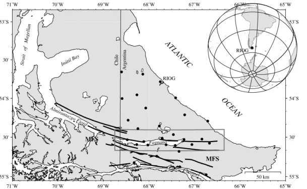
On the other hand, TDF is traversed by the boundary between the South American (SA) and Scotia (SC) tectonic plates (Bird, 2003). In this region the active plate bound-5
ary is represented by the Magallanes-Fagnano Fault System (MFS, Fig. 1). According to geological, geomorphological and geophysical results (Lodolo et al., 2003) the main fault runs E-W along a large part of the Lago Fagnano depression; in the western part of the lake the main fault trace turns NW across the northern lake shore. The tectonic regime of the MFS is primarily characterised by a transform, left-lateral relative hori-10
zontal movement between two blocks to the N and S of the main fault. In this work, vertical site velocities derived from geodetic GPS observations for eleven sites con-centrated in the area formerly occupied by the Fagnano paleoglacier are analysed and interpreted with regard to the question whether they reflect GIA processes associated to local/regional ice-mass changes since the LGM.
15
2 Observations and analysis
A regional geodetic GPS network in the Argentine part of TDF main island has been established and repeatedly observed since 1993 (Fig. 1). Based on these observations 3-D site velocities were determined for 30 sites (Mendoza et al., 2010). A strain anal-ysis of the horizontal velocity components yielded new insights into the present-day 20
tectonic processes associated with the plate boundary.
Here we deal with the vertical site velocity components and attempt to identify their principal driving force. We restrict ourselves to a subset of eleven sites, which are aligned close to the 54◦35′S parallel along Lago Fagnano and further to the E. This
subset exhibits a high spatial site density, compared to the remaining parts of the re-25
TCD
4, 1635–1645, 2010Do crustal deformations in Tierra del Fuego
reflect GIA?
L. Mendoza et al.
Title Page
Abstract Introduction
Conclusions References
Tables Figures
◭ ◮
◭ ◮
Back Close
Full Screen / Esc
Printer-friendly Version Interactive Discussion
Discussion
P
a
per
|
Dis
cussion
P
a
per
|
Discussion
P
a
per
|
Discussio
n
P
a
per
|
type (self-centring screw on bedrock, self-centring screw on concrete pillar, or tripod marker) of each individual site must be considered in the interpretation because it affects the representativeness of the determined vertical velocity. All the GPS sites considered here consist of monumentations of highest quality (self-centring screw on bedrock or concrete pillar).
5
The absolute vertical site velocities obtained by the GPS data processing are, in gen-eral, affected by uncertainties in the realisation of the global reference frame. However, the relative vertical velocity differences within a regional network are considered to be free of these systematic effects and can thus be interpreted as geophysical signal. We focus therefore on the inference and analysis of the spatial pattern of the vertical 10
velocities within the subnetwork.
These GPS sites cover the area once occupied by the Fagnano paleoglacier and, at the same time, form a 100 km long profile orientated radially towards the Cordillera Darwin ice sheet. This configuration can be expected to forward a high sensitivity of the subnetwork to both the local effects of the Late Pleistocene retread of the Fagnano 15
paleoglacier and the regional response to ice-mass changes in the Cordillera Darwin from the LGM through the present.
However, the investigated subnetwork coincides also with the supposed trace of the MFS (Figs. 1 and 2). The interpretation of the observed vertical velocities must therefore, in addition to GIA effects, also consider deformation processes related to 20
fault tectonics.
3 Results
The strain analysis of the observed horizontal velocities revealed the regime and pat-tern of the horizontal crustal deformations (Mendoza et al., 2010). The large-scale tec-tonic processes represent a transform left-lateral movement between two rigid blocks 25
TCD
4, 1635–1645, 2010Do crustal deformations in Tierra del Fuego
reflect GIA?
L. Mendoza et al.
Title Page
Abstract Introduction
Conclusions References
Tables Figures
◭ ◮
◭ ◮
Back Close
Full Screen / Esc
Printer-friendly Version Interactive Discussion
Discussion
P
a
per
|
Dis
cussion
P
a
per
|
Discussion
P
a
per
|
Discussio
n
P
a
per
|
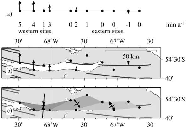
significant horizontal deformation (stretching, shortening) occurs. Along the studied MFS segment a striking change in the deformation regime is observed at 67◦50′W
(just E of the centre of Lago Fagnano): to the E a transtensional regime prevails while to the W transpression is encountered (Fig. 2c). Extension is also observed in the west-ern part, but offset further to the S and N from the main fault. Within the investigated 5
subnetwork (Fig. 2a and b) a sharp change in the vertical movements is observed: E of 67◦50′W the vertical velocities are close to zero whereas to the W uplift with rates of
up to 5 mm a−1 occur. The location of this change coincides with that of the change in
the horizontal deformation regime. Along the S shore of Lago Fagnano the vertical ve-locities rise gradually from E to W. On the N shore the vertical velocity jumps suddenly 10
from close to zero to the maximum uplift rate. This jump occurs between two GPS sites between which a fault segment was identified by Menichetti et al. (2008).
4 Interpretation and discussion
The observed E-W gradient in the uplift pattern is in general consistent with the ex-pected GIA effects after the retreat of the Fagnano paleoglacier and with the prediction 15
by Ivins and James (2004). Their model (their Fig. 3b) predicts for the area under investigation an increase in the uplift rate about twice as large as the observed one. However, that model run might be regarded as a maximum scenario for our area of interest. It assumes an unusually low asthenosphere viscosity all over Patagonia as-sociated with the subduction of the Antarctic tectonic plate along the South-American 20
Pacific coast. Nevertheless, GIA is expected to produce a long-wavelength crustal re-sponse signal. This contradicts the observed change in uplift rate of 5 mm a−1 over
some 20 km.
In fact, the detected large uplift gradients and their spatial correlation with both ob-served changes in the horizontal deformation regime and fault segments revealed 25
TCD
4, 1635–1645, 2010Do crustal deformations in Tierra del Fuego
reflect GIA?
L. Mendoza et al.
Title Page
Abstract Introduction
Conclusions References
Tables Figures
◭ ◮
◭ ◮
Back Close
Full Screen / Esc
Printer-friendly Version Interactive Discussion
Discussion
P
a
per
|
Dis
cussion
P
a
per
|
Discussion
P
a
per
|
Discussio
n
P
a
per
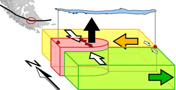
|
joint interpretation of the observed horizontal and vertical deformations is depicted schematically in Fig. 3. The pronounced changes in horizontal strain and rotation as well as uplift could be explained by the presence of a micro-block in the western part of Lago Fagnano. The transform displacement components are partitioned between faults bounding the immobile micro-block to the N and S. The micro-block receives 5
strong lateral pressure from the S and N causing N-S shortening (Fig. 2c) and uplift (Fig. 2a). The occurrence of strong compression in this area coincides with the change in the general direction of the MFS main trace from E-W to SE-NW (Fig. 3, inset).
Attributing the observed vertical deformations primarily to fault-tectonics, as sug-gested here, implies very low GIA effects in the area under investigation, in fact, about 10
factor 10 smaller than predicted by Ivins and James (2004). This might indicate that the rheological properties assumed in the modelling, in particular the low viscosity, may not represent precisely the actual conditions in the area of investigation somewhat distant from the active subduction zone. On the other hand, such small GIA effects could also be explained by much smaller ice-mass changes in the Cordillera Darwin throughout 15
the Holocene compared to the ice-load history assumed in the modelling and e.g. those inferred for the Southern Patagonian Icefield (Dietrich et al., 2009).
5 Conclusions and outlook
Geodetic GPS observations reveal the present-day vertical crustal deformation in the Argentine part of TDF. Processes related to both plate tectonics and GIA must be 20
considered in their interpretation. At present, our results point towards a dominance of a tectonic origin of the vertical deformations implying rather small GIA effects.
However, additional observation data are needed for a separation of both effects and to draw more reliable conclusions. Our investigations in TDF are continued. The signal-to-noise ratio of the determined vertical site velocities increases with each repetition of 25
TCD
4, 1635–1645, 2010Do crustal deformations in Tierra del Fuego
reflect GIA?
L. Mendoza et al.
Title Page
Abstract Introduction
Conclusions References
Tables Figures
◭ ◮
◭ ◮
Back Close
Full Screen / Esc
Printer-friendly Version Interactive Discussion
Discussion
P
a
per
|
Dis
cussion
P
a
per
|
Discussion
P
a
per
|
Discussio
n
P
a
per
|
fingerprint and tectonic structures. In particular, an extension of the GPS network into the Chilean part of TDF, with an emphasis on Cordillera Darwin and formerly glaciated areas, would be crucial for the quantification of GIA induced crustal deformations.
The regional glaciation reconstruction by Coronato et al. (2009) provides a valuable basis for a regional downscaling of the GIA modelling by Ivins and James (2004). In 5
addition, the ice-load history in TDF throughout the Holocene is required as the model predictions by Ivins and James (2004) and Dietrich et al. (2009) are dominated by the effects of recent and Holocene ice changes.
Acknowledgements. The field work was partly funded by SECyT (Argentina), IB/BMBF (Ger-many) and the German Research Foundation (DFG). L. Mendoza and A. Richter were sup-10
ported by scholarships of the German Academic Exchange Service (DAAD).
References
Bird, P.: An updated digital model of plate boundaries, Geochem. Geophy. Geosy., 4, 1027, doi:10.1029/2001GC000252, 2003. 1637
Bujalesky, G. G., Heusser, C. J., Coronato, A. M., Roig, C. E., and Rabassa, J. O.: Pleistocene 15
Glaciolacustrine Sedimentation at Lago Fagnano, Andes of Tierra del Fuego, Southernmost South America, Quaternary Sci. Rev., 16, 767–778, 1997. 1636
Coronato, A., Sepp ¨al ¨a, M., Ponce, J. F., and Rabassa, J.: Glacial geomorphology of the Pleis-tocene Lake Fagnano ice lobe, Tierra del Fuego, southern South America, Geomorphology, 112, 67–81, doi:10.1016/j.geomorph.2009.05.005, 2009. 1637, 1641
20
Dietrich, R., R ¨ulke, A., and Scheinert, M.: Present-day vertical crustal deformations in West Greenland from repeated GPS observations, Geophys. J. Int., 163, 865–874, doi:10.1111/j.1365-246X.2005.02766.x, 2005. 1636
Dietrich, R., Ivins, E. R., Casassa, G., Lange, H., Wendt, J., and Fritsche, M.: Rapid crustal uplift in Patagonia due to enhanced ice loss, Earth Planet. Sc. Lett., 289(1–2), 22–29, 25
doi:10.1016/j.epsl.2009.10.021, 2009. 1636, 1640, 1641
TCD
4, 1635–1645, 2010Do crustal deformations in Tierra del Fuego
reflect GIA?
L. Mendoza et al.
Title Page
Abstract Introduction
Conclusions References
Tables Figures
◭ ◮
◭ ◮
Back Close
Full Screen / Esc
Printer-friendly Version Interactive Discussion
Discussion
P
a
per
|
Dis
cussion
P
a
per
|
Discussion
P
a
per
|
Discussio
n
P
a
per
|
Lodolo, E., Menichetti, M., Bartole, R., Ben-Avraham, Z., Tassone, A., and Lippai, H.: Magallanes-Fagnano continental transform fault (Tierra del Fuego, southernmost South America), Tectonics, 22(6), 1076, doi:10.1029/2003TC001500, 2003. 1637
Mendoza, L., Perdomo, R., Hormaechea, J. L., Del Cogliano, D., Fritsche, M., Richter, A., and Dietrich, R.: Present day crustal deformation along the Magallanes-Fagnano fault system 5
in Tierra del Fuego from repeated GPS observations, submitted to Geophys. J. Int., 2010. 1637, 1638
Menichetti, M., Lodolo, E., and Tassone, A.: Structural geology of the Fuegian Andes and Magallanes fold-and-thrust belt – Tierra del Fuego Island, Geol. Acta, 6, 19–42, 2008. 1639, 1643
10
TCD
4, 1635–1645, 2010Do crustal deformations in Tierra del Fuego
reflect GIA?
L. Mendoza et al.
Title Page
Abstract Introduction
Conclusions References
Tables Figures
◭ ◮
◭ ◮
Back Close
Full Screen / Esc
Printer-friendly Version Interactive Discussion
Discussion
P
a
per
|
Dis
cussion
P
a
per
|
Discussion
P
a
per
|
Discussio
n
P
a
per
|
MFS MFS
Fagnano
RIOG
Chile
Argentina
Inútil Bay
Almirantazgo Fjord
ATLANTIC OCEAN
Strait of Magellan
30' 30'
30' 30'
71˚W 71˚W
70˚W 70˚W
69˚W 69˚W
68˚W 68˚W
67˚W 67˚W
66˚W 66˚W
65˚W 65˚W
55˚S 55˚S
54˚S 54˚S
53˚S 53˚S
50 km
Beagle Channel
RIOG
TCD
4, 1635–1645, 2010Do crustal deformations in Tierra del Fuego
reflect GIA?
L. Mendoza et al.
Title Page
Abstract Introduction
Conclusions References
Tables Figures
◭ ◮
◭ ◮
Back Close
Full Screen / Esc
Printer-friendly Version Interactive Discussion
Discussion
P
a
per
|
Dis
cussion
P
a
per
|
Discussion
P
a
per
|
Discussio
n
P
a
per
|
30'
30'
30'
40'
68˚W
67˚W
54˚30'S
c)
30'
30'
30'
40'
68˚W
67˚W
54˚30'S
50 km
b)
western sites
eastern sites
5
4
1
3
0
2
1
0
0
-1
0
mm a
-1a)
Fig. 2. Geodetic results obtained in the Lago Fagnano area.(a)and(b)vertical site velocities
as derived from the GPS observations;(c)horizontal crustal deformation as derived from the
TCD
4, 1635–1645, 2010Do crustal deformations in Tierra del Fuego
reflect GIA?
L. Mendoza et al.
Title Page
Abstract Introduction
Conclusions References
Tables Figures
◭ ◮
◭ ◮
Back Close
Full Screen / Esc
Printer-friendly Version Interactive Discussion
Discussion
P
a
per
|
Dis
cussion
P
a
per
|
Discussion
P
a
per
|
Discussio
n
P
a
per
|