IMPACT OF MINING ACTIVITY UPON ENVIRONMENT
IN RO IA MONTAN
Ă
SIGISMUND DUMA
1ABSTRACT – Ro ia Montană is the greatest gold ore in Romania and one of the greatest in Europe,
and its exploitation has been carried out since Antiquity up to nowadays.
If the traditional extraction and processing technologies had a minimal impact upon environment, the ones adopted in modern times have affected all the components of the natural environment.
In the perspective of capitalizing the gold ore through the programme elaborated by the Canadian company, Gold Corporation, the zonal geographical space will be degraded up to the level of industrial dessert over an area of 100 km2 and in case of damage, the affected area can extend enormously.
The environmental problems are related both to the specific nature of such an industrial activity and, especially, to the use of enormous quantities of sodium cyanide directly on the preparation flux from the industrial plant.
Few such cases are known worldwide, in several economically less developed countries. Usually, cyanides are used for treating the gold concentrations, operation done in conditions of maximum security, in closed spaces, situated in isolated zones and the neutralization (detoxification) of cyanides is done in situ. The treatment of cyanides in open spaces has always generated environmental problems. Moreover, none of the cyanide treatment technologies eliminates entirely their toxic effect (less toxic chemical products are obtained).
In order to avoid the production of an environmental disaster and to preserve the local patrimony values (in this place there lies the richest mining archeological site in Europe), we elaborated several recommendations we consider feasible as they allow both the capitalization of ore, which is a socio-economic necessity of the area, and the ecological reconstruction of the affected geographical space.
Key words: gold, Ro ia Montană, mining activity, ecological impact, risks.
A SHORT HISTORY OF MINING ACTIVITY IN RO IA MONTANĂ
The history of Ro ia Montană is closely related to the exploitation of gold resources and has
undergone three significant periods: Antiquity, with the ample system of Roman exploitations; Middle Ages, with the traditional exploitation type, and modern period, characterized by technological development.
In Antiquity, at Ro ia Montană (Alburnus Maior), mining works were executed since 131 A.D.
Nowadays, 24 km of Roman mine galleries and mining works are still preserved, out of which, some have been arranged, inclusively electrically lighted, and rendered to visitors. The ancient historians recorded data about mining on the famous wax tablets that contain the miners’ and employers’ obligations, among which, a credit contract of a local moneylender named Iulius Alexander. Hard rock ore extraction was made by using fire (fire + water = sudden cooling and decrepitation), chisel, holes filled with water and plugged with a wooden plug, which, by repeated strokes created pressures generating the cleavage of the gold ore, which was processed through crushing, followed by gold washing and amalgamation (Sântimbreanu A. i Wollmann, N., 1982).
In the Middle Ages, mining is documentarily attested since 1238 and was led by the Transylvanian Saxon colonists, the locality being named Rubeo Flumine (Red River) and later on, Rotseifen and Rotbach. During this period, chisel continued to be used for making holes, but gold removal from the hard rock was made by using black powder (gun powder), techniques preserved up to modern period (Sântimbreanu A. i Bedelean, H., 2002).
In the modern period, marked by the Industrial Revolution, ample mining works were carried out in Ro ia Montană, both by state (the Habsburg Empire) and by private investors. The system of
artificial ponds (“tăuri”) was arranged to supply water for the gold ore comminution machines (1,200
stamping mills). At the end of the 19th century and beginning of the 20th century, gold ore exploitation and processing took great proportions and Ro ia Montană developed economically, reason for
detaching itself territorial-administratively from the town of Abrud. After the Great Union (1918), the Romanian state involved itself and encouraged private exploitations, which registered a strong revival during the years before the nationalization from 1948.
During the communist period, planned mining developed, initially for paying the war debts (till 1963) and, subsequently, for paying other debts the Romanian state plunged into. The stamping mills were destroyed and the canals used for conducting water towards stamping mills and other components of the traditional mining were removed. High productivity underground exploitation technologies were attempted (sublevel caving method), but they failed, and therefore, starting with 1970, exploitation began at Cetate opencast pit. Out-of-date processing technologies and the frequent flux interruptions in the preparation plant determined great gold losses found today in the tailings settling ponds.
After 1990, a progressive social and economic degradation began, activity continuing, however, until 2005-2006, when any kind of mining activity in the area was stopped. In these circumstances, the issue of privatizing the mining objective was raised, the only participant to the acquisition auction being the Canadian company, Gold Corporation. Thus, the public debate regarding the perspective of capitalizing the gold reserves through the above-mentioned company begins. Two groups, pros and cons, appeared, the Zonal Urban Plan was elaborated; the main issues of the debate being those related to the destruction of the Ro ia Montană historic site and to the use of enormous quantities of
potassium cyanide in the ore processing activity.
ORE GEOLOGY
The Ro ia Montană gold ore lies in the “Gold Quadrilateral” of the Metaliferi Mountains within
the Southern Apuseni Mountains. The geologic structure within the region includes metamorphic rocks, Mesozoic ophiolites, Cretaceous magmatites (Upper Palaeogene), Neogene igneous rocks, Mesozoic and Miocene sedimentary rocks, Quaternary sediments (Fig. 1.)
The Ro ia Montană ore is situated in the northeastern part of the Metaliferi Mountains and is
included into the morphostructural subunit of the Ro ia Montană Mountains, Ro ia-Bucium
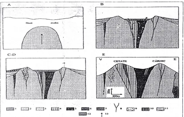
metalogenetical district. The geological structure and the metalogenetical evolution of the main ore body, Cetate Cârnic, are shown in Figure 2.
Mineralization is mainly auriferous, all the other elements, associated under the form of sulfides, being totally subordinated, and presents itself under the form of lodes, stockworks, and impregnation zones. Lodes are north-south or east-west oriented and have inclinations from 450 (chairs) up to almost a vertical position. Generally, lodes, and especially “chairs”, are thin (0.1-0.5 m) and contain mainly native gold. Stockworks are situated in the breccia columns with mineralizations under the form of veinlets and with native gold impregnations. Impregnations develop within the mass of the dacite formed around the breccia columns.
Figure 1.Geological map of the Metaliferi Mountains from the Southern Apuseni Mountains, with the distribution of auri-argentiferous ores and porphyry copper
(according to Bo tinescu, M., 1984, quoted by Popescu, Ghe. and colab., 2007).
The mineral association known in this ore is gold, blende, galena, alabandine, pyrite, marcasite, mispickel, chalcopyrite, rhodochrosite. In the area, several gold ore bodies are known:
Carpen-Orlea-łarina, Cetate, Cârnic, Cârnicel, Foie -Igre-Văidoaia. Opencast mining is grafted only on the gold
mineralizations from the Cetate body, localized in the dacitic massif and represented by stockworks and lodes.
The most important stockworks are: Ro eŃe- tefan-Contact; Juho, Ierusalim, Bora ai, Afini ,
Bako i, Mangan, and Cetate. Lodes have small dimensions: lengths of about 50-150 m and thicknesses of 0.1-0.5 m. The mineralization of stockworks and of lodes consists of gold, pyrite, blende and galena, included into a quartz and rhodochrosite gangue (Duma, S., 1998).
Gold ore reserves are estimated to 215 million tones, with an average content of 1.5 g/tone gold and 6 g/tone silver (322.5 t gold and 1290 t silver). A great quantity of gold is found also in the tailings from the settling ponds.
Geology of the Southern
Apuseni Mountains
Romania
(Bo tinescu, 1984)
Legend
Quaternary sediments
Miocene magmatic rocks
Miocene sedimentary rocks
Upper Cretaceous- Palaeogene magmatites
Mesozoic
sedimentary rocks
Mesozoic ophiolites
Metamorphic rocks
Faults and fractures
Mure Fault
Porphyry copper (-gold) ores
IMPACT OF MINING UPON ENVIRONMENT
In the Cetate opencast pit, the gold ore reserve, remained from the underground mining activity, was exploited. This is due to the fact that, through underground exploitation, great losses of reserves were registered (more than 70%). Thus, in the opencast pit, the old underground mining works can be found (mine galleries, raising shafts), which raise special problems, technical, technological, of work and environment protection (Fig. 3.).
The relief from the area of the Cetate opencast pit and the waste dumps is affected by the transfer of mine mass, which leads to the modification of zonal morphometry and morphology through opencast excavations as negative forms and mine waste dumps as positive pseudoforms of relief. In the opencast pit, due to the existence of old mining works (galleries, raising shafts, pillars) a correct geometrization of the levels cannot be done.
Mine waste dumps, as positive microforms of relief, occupy an area of 13.14 ha and they are 16 in number, out of which only two are recent: Valea Verde waste dump and Hop waste dump.
Valea Verde waste dump has an area of 5.0 ha and comprises 2 levels, first at the elevation of +875 m and the last at the elevation of +900 m, the height of the waste dump being of approximately 80 m.
Figure 2. Ro ia Montană Metalliferous Field, Cetate-Cârnic mineralized structure, Metaliferi Mountains (Southern Apuseni Mountains): A. Formation of the Cetate dacite; B. Genesis of the Cetate phreatomagmatic breccia – fluidization circuit is functional (Glamm formation and Cetate breccia in the classic sense); C and D. Au-Ag mineralizations (impregnations, phreatic breccia, tectonic breccia, lodes, cavity fillings, stockworks, placers, etc.); E. Present image of the Cetate-Cârnic structure; 1-2. Host rocks
(1. Cretaceous, 2. Neogene); 3. – Cetate dacite; 4. –Cetate breccia (classic sense); 5. – Glamm formations – fluidization canal; 6. – Tectonic breccias; 7. – Phreatic breccias (superposed on the phreatomagmatic breccia column); 9. – Stockworks; 10. – Auriferous placers; 11. – Talus deposits; 12. – Sediments of Maar
type; 13. – Direction of transport
Figure 3.Ro ia Montană. Cetate opencast pit. (Source: http://rosiamontana.org)
Hop waste dump is smaller and has an area of 3.8 ha, depositing being done only on one platform, at the elevation of +900m.
Both of them are slope waste dumps and present a relative degree of stability; under the Valea Verde waste dump, at a distance of 500 m, there lies the village of Corna.
Processed tailings settling ponds totalize an area of 35.92 ha, out of which 11 ha are covered by the Valea Săli tei settling pond and 24.92 ha by the three settling ponds from Gura Ro iei.
On the talus of the Valea Săli tei settling pond, frequent landslides are recorded and on the
taluses of the settling ponds from Gura Ro iei, intense erosional processes develop (Fig. 4).
Dusts, usually silicogenous, nitrogen oxides, and aerosols proceeding from the flotation reagents represent the main noxes emitted into the air from the zone of industrial platforms. Fine sands are wind-borne from the settling ponds, and, in the proximity of the Valea Săli tei settling pond, the
smell of bitter almonds, specific to sodium cyanide, is often felt. It is known the fact that the cyanides emitted into the air under the form of gaseous hydrocyanic acid attach to the dust particles and remain in the atmosphere for a period of 1-3 years (Witt et al., 2004).
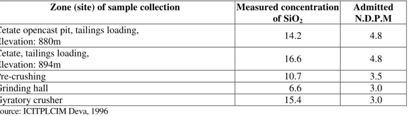
The operations of perforation, blasting, loading, gravitational transport by means of collectors, as well as ore crushing operations are also generators of air pollution with silicogenous dusts. The degree of pollution with SiO2 dusts in different zones and work places is rendered in Table 1, a major exceeding of SiO2 concentration being noticed in all the sample collecting points.
Table 1. Air quality at the Ro ia Montană mining objective.
Zone (site) of sample collection Measured concentration of SiO2
Admitted N.D.P.M Cetate opencast pit, tailings loading,
Elevation: 880m 14.2 4.8
Cetate, tailings loading,
Elevation: 894m 16.6 4.8
Pre-crushing 10.7 3.5
Grinding hall 6.6 3.0
Gyratory crusher 15.4 3.0
Source: ICITPLCIM Deva, 1996
The main water collector within the Ro ia Montană mining perimeter is the Valea Ro iei creek, in
whose retention basin Cetate opencast pit is also situated. In this place, there are the only lakes in the country arranged for washing gold ore in stamps. These are: Tăul Mare, situated between Cârnic and
Cuibarului Hill; Tăul łarina, near Văidoaiei peak; Tăul Brazilor and Tăul Anghel, above the locality of
Ro ia Montană (near Cârnic Hill); Tăul łapului, on the upper course of Valea Săli tei (upstream the
tailings settling pond) and Tăul Cornii, upstream the village of Corna. The only lake affected by pollution is
Tăul Mare, in which a part of the waters from the Cuibaru waste dump area, within the Ro ia Poieni
objective, flows.
In the area of Cetate opencast pit, the hydrographic network was totally disorganized. Rainwaters infiltrate into underground through old mining works and thus, washing the mineralization. They are collected at the level of transport gallery where they are discharged into the Valea Ro iei creek under the form of acid drainage (galiŃă2).
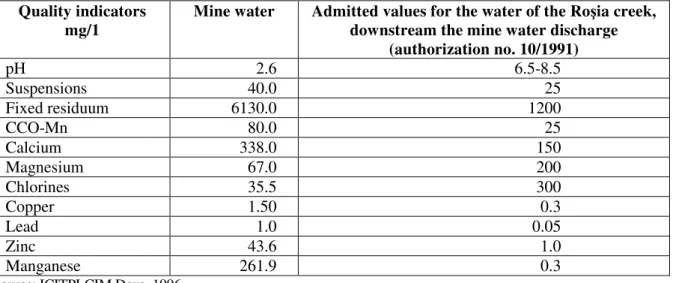
Mine waters are not of quality, being polluted. Very high exceedings are noticed for almost all indicators, harmful elements inclusively: lead, zinc, and copper; pH is also alarming (Table 2).
As result of this situation, the biota from the Valea Ro ia waters has totally disappeared and because of the pollution of the phreatic level in the valley’s small floodplain, wells have been partially abandoned.
Table 2. Water quality in Cetate mine.
Quality indicators mg/1
Mine water Admitted values for the water of the Ro ia creek, downstream the mine water discharge
(authorization no. 10/1991)
pH 2.6 6.5-8.5
Suspensions 40.0 25
Fixed residuum 6130.0 1200
CCO-Mn 80.0 25
Calcium 338.0 150
Magnesium 67.0 200
Chlorines 35.5 300
Copper 1.50 0.3
Lead 1.0 0.05
Zinc 43.6 1.0
Manganese 261.9 0.3
Source: ICITPLCIM Deva, 1996
Industrial water for Gura Ro iei processing plant is taken from the Abrudel creek through a water inlet situated 300 m upstream the plant, but downstream the discharge of the cleared water from the Valea Săli tei settling pond.
The quality of technological waters is affected by the great quantities of impurifiers: suspensions, CCO-Mn, sulphides, iron, manganese, zinc, copper, and cyanides (Table 3).
Table 3. The quality of industrial water and of the Valea Săli tei settling pond water.
Quality indicators mg/1
Abrudel valley industrial water
Cleared water, Valea Săli tei settling pond
Admitted values, according to
C.G.A. M.11/88; STAS 4706/88
pH 6.0 5.5 6.5-85
Suspensions 75.0 58 25
Fixed residuum 612 980 1200
CCO-Mn 253 49.1 25
Magnesium 12.2 206 200
Chlorides 28.4 28.4 300
Sulphides 3,194 485 400
Cyanides 0.014 0.018 0.02
Copper 0.17 0.11 0.2
Lead 0 0.16 0.2
Zinc 126 1.95 0.2
Manganese 7.5 335 0.2
Calcium 116 145 150
Source: ICITPLCIM Deva, 1996
For them, the contents of 0.03 mg/l HCN in water are fatal (Witt et al., 2004). It is interesting to mention that the content of cyanides of the Abrudel’s water is close to the one existent in the cleared water coming from the Valea Săli tei settling pond. It must be mentioned the fact that the water discharge of the Abrudel
is at lest 20 times higher than the one of Valea Săli tei (cleared waters). In these conditions, the content of
cyanides of the Abrudel’s water should be, due to dilution, 20 times lower. An elementary logic obliges us to make a reversed calculus from which it results a content of cyanides for cleared waters of 0.36 mg/l, which is more beyond the admitted one (0.02 mg/l).
The soil cover within the Ro ia Montană exploitation perimeter is represented by acid brown soils,
argillic brown soils and sometimes cambic podzols, albic luvisoils, usually eroded up to the level of B-horizon, and undeveloped soils (alluvial protosoils) in the Abrudel floodplain and in the small floodplain of the Valea Ro ie creek.
In the area of Cetate opencast pit, soils have been removed together with ore uncovering, and in the area of waste dumps and tailings settling ponds, soil was covered with the tailings wastes from mines and processing plants.
The very intense erosion on the Cârnic and Cârnicel hills has also led to soil cover removal. Alluvial soils in the Abrudel floodplain have been also texturally affected due to flotation sand flow and its inclusion into their composition through agricultural works.
Chemically, floodplain soils have undergone an addition of very harmful elements such as lead, zinc, and copper. Lead usually accumulates at the soil surface, being easily taken over by the plants with a radicular system developed at the level of biological horizon. The negative effects of the presence of lead into soil come out from the slowing down or the blocking of fermentation processes, fact which implicitly leads to crop decrease. Lead accumulates into plants (leaves, straws, grains, tubers) from where it passes to consumers. The zinc from soil diminishes biological activity, hinders the fermentation processes from soil and operates upon barley, bean, maize, potato, etc. crop reduction. It accumulates especially in the green organs of plants. The copper from soil reduces the intensity of plants’ respiration, slows down the process of chlorophyll formation, hinders the activity of some microorganisms and reduces the activity of some ferments (Duma, S., 2006).
The forestry vegetation in the area, formed of oak forests and mixed oak and beech forests, has been exploited since the beginning of mining activity (Dacian-Roman period), wood being used for supporting underground mining works, as well as for other uses. Nowadays, the forestry vegetation from the surrounding area of the opencast pit appears under the form of some clusters of trees and shrub whose growing rate has been reduced by dust depositions on leaves, which, through stoma obstruction have slowed down photosynthesis. The herbaceous vegetation of secondary grasslands is also poor. The fruit trees near the opencast pit are not pollinated by bees anymore, they do not fructify, or they rarely fructify, also due to dust depositions on flowers.
The biota from the surface waters has totally disappeared and the cynegetic fauna has been vanished by the activities taking place in the opencast pit, detonations inclusively.
The industrial mining perimeter lies in the immediate proximity of the built-up area of Ro ia Montană, representing thus an element of landscape aggressiveness.
PERSPECTIVES OF VALORIZING THE ORE FROM RO IA MONTANĂ AND THE ENVIRONMENTAL ISSUE
over 100 km2. 975 households will be displaced, out of which 41 houses of patrimony, 7 churches (two Greek Catholic, two Orthodox, one Roman Catholic, one Unitarian, and one Calvinist), and 11 graveyards, here lying the richest archaeological site in Europe. The Roman road, Roman galleries (24 km), Roman camp and the Roman city dating from 130-140 A.D. will be also destroyed. Nature monuments such as Piatra Despicată – 0.3 ha and Piatra Corbului - 5 ha, and the Brazi, Anghel, łarina, Corna, łapului, Găuri, and Lacul Mare artificial lakes will disappear. Practically, out of the
entire historical site, only 1/20 of the area will remain and this surrounded by former opencast pits, mining waste dumps, tailings ponds, etc. In this place, a real landscape dessert will be established. Only a part of the historical centre will remain, where the rehabilitation of several buildings and the construction of new buildings that, architecturally, have no connection with the traditional local specificity, have been planned.
In case the
Ro ia Montană ore is accepted to be valorized, the following
recommendations must be made:
-
qualitative reevaluation of ores by the Romanian state institutes;- priority in processing the tailings from the Gura Ro iei and the Valea Săli tei settling ponds,
with depositing the tailings in the same locations and renouncement to building the Valea Cornii settling pond;
- maintenance and preservation of the archaeological and historical site and exploitation of the ore bodies that do not affect them;
- adoption of gold ore processing technologies that do not use sodium cyanide, possibly gravitational technologies that once were used here (see stamping mills) or technologies of lye washing using tithiourea, tithiosulphates, or gaseous chlorine;
- depositing the processed tailings resulted from processing the ore coming from the
Valea
Săli tei
settling pond by superelevating it (the morphological profile of the valley allows it), and, as the ore is extracted from the Cetate opencast pit, the remained gap should be filled in (embanked) with processed tailings;- neutralization of the acid drainage and the proofing of the tailings settling ponds’ hearth with natural binders (concrete or clay);
- achievement of final ecological reconstruction, which should include deposition of fertile soil on the settling ponds and planting forestry vegetation on all the areas affected by ore extraction and processing activities (mining and processed waste dumps, opencast pits, access roads, etc.);
- of course, by using other ore processing technologies, the length of ore exploitation will be prolonged to a period of 30-40 years, a fact in the advantage of local people.
In these conditions, both ore exploitation, which is a socio-economic necessity in the area, and a relative preservation of natural and anthropic environment may be accomplished, which, on long term, will allow a tourist valorization of local cultural-historical patrimony.
REFERENCES
DUMA, S; (1998), Studiul geoecologic al exploatărilor miniere din zona sudică a MunŃilor Apuseni, MunŃii Poiana Ruscă i MunŃii Sebe ului, Edit. Dacia, Cluj-Napoca.
DUMA, S; (2006), Resursele i mediul, Edit. Universitară Bucure ti.
DUMA, S; (2007), Resursele crustale mondiale, Edit. Presa Universitară Clujană, Cluj-Napoca.
POPESCU GHE. I COLAB; (2007), Geologia economică a aurului, Edit. Aeternitas, Alba Iulia. POPESCU GHE; ARU D; (1997), The Apuseni Mountains. The mining activity environmental
impact. Eng. Geol. and. Marines et al. (eds), 1977, Balkena, Roterdam.
SÂNTIMBREANU, A; BEDELEAN, H; (2002), Ro ia Montană, Alburnus Maior - Cetatea de scaun a aurului românesc, Edit. Altip, Alba Iulia.
VLAD, S.N; (2005), Tipologia i gestiunea resurselor minerale metalifere, Edit. Casa CărŃii de
tiinŃă, Cluj-Napoca.
WITT, K.J; SCHÖNRADT, M; SAARELA, J; FRILANDER, R; CSICSAK, J; CSÖVARI, M; VÁRHEGYI, A; GEORGESCU, D.P; RĂDULESCU, C.A;, ZLĂGNEAN, M.; BÕHM, J;
DEBRECZENI, Á; GOMBKÖTÕ, I; XENIDIS, A; KOFFA, E; KOURTIS, A; ENGELS, J; (2004), Sustainable Improvement in Safety of Tailings Facilities; Report: Tailings Management Facilities - Risks and Reliability European Research and Technological Development Project, Contract Number: EVGI-CT-2002-00066
* * * Proiect pentru Muzeul Mineritului din Ro ia Montană, S.C. BLIPSZ S.R.L. i S.C. General
Game S.R.L.
* * * Studiu de impact asupra mediului la unităŃile miniere din cadrul C.M. Deva, I.C.I.T. P.L.C.I.M. Deva, 1996
* * * Wild and Enivironmental Mining of British Columbia, Canada, 1998- Mining & Water Pollution, Issues in BC.