13 http://biology.num.edu.mn
http://mjbs.100zero.org/ Volume 10(1-2), 2012
Mongolian Journal of Biological
Sciences
ISSN 2225-4994 (online edition)
MJBS
Original Ar• cle
Key Resource Areas of an Arid Grazing System of the
Mongolian Gobi
Frédéric Joly
1,2*, Slim Saïdi
3, Tsevelmaa Begz
1,4and Claudia Feh
11Association pour le cheval de Przewalski: TAKH, Station Biologique de la Tour du Valat, Le Sambuc, 13200
Arles, France, e-mail : joly@takh.org, tel: +33 490 97 23 13, fax: +33 490 97 20 19
2AgroParisTech, 19 avenue du maine, 75732 Paris Cedex 15, France
3Cirad-Tetis, Campus International de Baillarguet, 34398 Montpellier Cedex 5, France 4Khovd University of Mongolia, Khovd City, Mongolia
Abstract
Degradation of the world’s drylands ranks among the greatest contemporary environmental problems. Between 10 and 20% of them are already degraded, and most of this degradation can be attributed to human activities (Millennium Ecosystem Assessment, 2005). Their sustainable use is therefore urgently needed. Since pastoralism is the main use of drylands, it requires an accurate understanding of the relationships between livestock and vegetation (Suttie et al., 2005).
During the last decade of the 20th century
the two concepts aiming at describing these relations in arid environments, the ‘equilibrium model’ and the ‘non-equilibrium model’, have
been opposing each other. In the equilibrium model, vegetation and herbivores are assumed to live in a balance in which pasture condition is the result of interactions between grazing and plant primary production. The associated management consists in estimating the amount of forage produced by the concerned pasture, and calculating the number of animals that can be fed on it, i.e. its carrying capacity (Vetter, 2005). In the non-equilibrium model, forage production fl uctuations due to the precipitation variations inherent to arid climates are so high, that livestock numbers can not track them (Ellis & Swift, 1988). In addition, extensive multi-year droughts regularly lead to massive die-offs, Arid grazing systems can behave according to both equilibrium and non-equilibrium models, depending on spatial and temporal scales. Regarding spatial aspect, key resource areas with access to water bodies can indeed be in equilibrium with livestock while rainfall dependent areas can be non-equilibrium. It is important to understand the application range of each of the models, since associated management is different. We studied the plant communities on a Mongolian Gobi site, paying particular attention to the communities connected to the water table. We found evidence that the vegetation structure on the main river’s fl oodplain is shaped by grazing, meaning that it is in the equilibrium model condition. This vegetation type covers 7.61% of our study site. We therefore concluded that from a spatial viewpoint, at least 7.61% of our site behaves according to the equilibrium model.
Key words: equilibrium model, non-equilibrium model, threshold,
plant communities, mapping.
Article information: Received: 02 Mar. 2012 Accepted: 26 Sept. 2012 Published: 25 Dec. 2012 Correspondence: joly@takh.org
Cite this paper as: Joly, F., Saïdi, S., Begz, T. & Feh, C., 2012. Key resource areas of an arid grazing system of the Mongolian Gobi. Mong. J. Biol. Sci., 10(1-2): 13-24.
Introduction
which are assumed to prevent livestock numbers from getting too high to impact vegetation. In this model, livestock has no real effect on pasture condition, and is consequently unable to cause degradation of vegetation (Scoones, 1995). In this context, the appropriate management relies on fl exibility in order to utilize a very unpredictable grass resource. An opportunistic approach based on mobility is therefore recommended to exploit the fl uctuant and patchy rainfall of the arid environments (Vetter, 2005).
Some authors challenged this dualistic perspective and contended that the reality stands between the two models, notably due to the existence of ‘key resource areas’. The key resource areas are habitats within arid systems, such as drainage lines or wetlands, that can provide forage with much less fl uctuation than rangelands (Illius & O’Connor, 1999). Vegetation and livestock can be coupled in these key resource areas, while being uncoupled in the rest of the system. For example, during a post-drought population recovery, animal numbers increase, and ultimately become density dependent with the key resource areas which operate in a source-sink manner. In the rest of the concerned system, the vegetation fl uctuates according to rainfall variation, but the herbivore population continues to increase. In this case, vegetation and herbivores are uncoupled. In the end, the population is either limited by forage resources (in particular those offered by the key resources areas), or reduced by a new drought. Livestock thus becomes in equilibrium with vegetation in certain places at certain times, while it remains in non-equilibrium with the rest of the area.
It is therefore now admitted that arid grazing systems can behave according to both of the models, depending on spatial and temporal scale (Vetter, 2005).
It is important to precisely understand the conditions of application for each of the models, because the associated management tools are distinct.
Mongolia offers a good opportunity to improve our understanding of the models applicability, since studies identifi ed characteristics of both of them in the country. In the north, the equilibrium model is predominant, while in the drier south, the non-equilibrium model prevails (Fernandez-Gimenez &
Allen-Diaz, 1999; Wesche & Retzer, 2005; Okayasu et al., 2011).
In this paper we want to improve our understanding of the models’ applicability at site scale by studying a system where the non-equilibrium model hypothetically prevails. However, some wetlands are present and we want to know if they can play the role of key resource areas. If so, we also want to determine to which extent these wetlands move the study site towards the equilibrium model. In this aim, we studied the local wetlands and drylands, and started discussing their distribution patterns. We did this through a description and mapping of the local vegetation communities.
Material and Methods
The study site is called Khomyn Tal. It consists of one bag (microdistrict), the smallest administrative unit of Mongolia, which is also the local livestock management unit. It is located in the west of the country in Onts bag, Durvuljiin district, Zavkhan province (center coordinates N 47°56’54.82’’; E 93°38’29.36’’). It is located in the semi-desert steppe vegetation zone of Mongolia (Hilbig, 1995) and according to the mapping by Okayasu et al. (2011), the site is in an area that acts in accordance with the non-equilibrium model.
The region is a buffer zone of the Khar Us Nuur National Park (Fig. 1). Lakes, such as Durgun and Khar Lakes in the west, Zavkhan River in the east, and large sand dunes toward the south form natural borders. The 2,900 km2
area is a vast plain whose altitude gradually increases from 1,200 m a.s.l. in the north to 1,300 m a.s.l. in the south. A small rocky range called Seer is present in the south-east. Khomyn Tal has a typical continental climate, with average annual temperatures between 0 and -2°C, and annual precipitation between 50 and 100 mm (Tsegmid & Vorobev, 1990). Winter is harsh: the daily average temperatures lies below -30°C for 30-40 days (Tsegmid & Vorobev, 1990).
About 45 transhumant pastoralist families move their traditional Mongolian felt tents around four seasonal camps (spring, summer, autumn and winter). They breed sheep, goats, horses, cattle and camels.
reintroduction sites of the only genuine wild horse, the Przewalski’s horse (Equus ferus przewalskii). Recently this species was classifi ed ‘extinct in the wild’, it is now categorized as ‘endangered’ (IUCN, 2011). Following a ‘soft release’ approach, 22 horses were introduced in a 14,000 ha fenced area in the south-east of Khomyn Tal in 2004 and 2005. In time, the horses will freely roam across the buffer zone. The site is also home to several populations of wild ungulates (Procapra gutturosa, Gazella subgutturosa, Saiga tatarica and Capra sibirica).
Description and mapping of the vegetation communities
Spatial vegetation sampling plan. Studying vegetation communities at a landscape scale in a 2,900 km2 area was possible, because ecological homogenous units are large. However, a sound sampling plan was required to take into account the variability of the site. We used stratifi ed sampling based on the following cartographic data:
- Topographic data derived from the world Digital Elevation Model (DEM) provided by NASA from the Shuttle Radar Topography Mission (SRTM - http://srtm.usgs.gov)
- Pedological data derived from a soil map (Tsegmid & Vorobev, 1990)
- Vegetation density data with ten density classes derived from the Perpendicular Vegetation Index (PVI) well adapted to sparse
vegetation (Panda et al., 2010), calculated from a LANDSAT 5 satellite image of 2000.
These maps were superimposed by a GIS software (ArcGIS 9.1) to return polygons of identical altitude, soil and vegetation density (Fig. 2). Only the polygons whose area exceeded 4 ha were kept. Smaller polygons were aggregated with their biggest neighbor. Finally, 239 sample polygons were obtained and considered representative of Khomyn Tal’s ecological variability.
Field sampling. Centroids of the polygons were generated by GIS and uploaded into a handheld GPS (Garmin Etrex Legend Cx) to
Figure 1. Location of Khomyn Tal.
allow navigation in the fi eld. A fi rst visit of the centroids took place in May 2006 to allow a visual classifi cation of the physiognomy of the vegetation. From this, we defi ned a consistent length to describe species cover by the line point intercept method (Herrick et al., 2005):
- Wet riverbed dense meadow: 10 m - Sand dune grassland: 20 m
- High foothill scrub: 100 m - Rest of the arid rangelands: 50 m
Two hundred and thirty nine sample plots were studied by line point intercept inside the polygons between mid July and early September 2006. They consisted in moving a needle along a tape of 100 points, every one/hundredth of the above mentioned length. Contact of the species with the needle was recorded and cover calculated from the number of points where a species occurred. As 100 points were used, the number of times a species touched the needle was a direct percentage of the cover. Presence of species within one meter from the tape was also recorded, such species were attributed a cover of 0.1%. In addition, we look some 'fast plots' in route, where only the two dominant species were recorded together with the main ground substrate. Locations of these plots were taken by GPS. The species encountered were identifi ed with the help of keys by Grubov (2001).
Only seeds enable one to distinguish between the local Stipa glareosa and Stipa gobica, they are thereforeoften lumped together in vegetation studies (Fernandez-Gimenez & Allen-Diaz, 1999; Wesche et al., 2005). As we had no seeds available at each sampling polygons, we also lumped them because it has few consequences on our purpose of discriminating between xeric and mesic grazing forage places. They are both nutritive grasses of desert steppe (Jigjidsuren & Johnson, 2003).
Classifi cation of plots and description of the vegetation types. Sampling plots were classifi ed according to their species composition by a Two-Way-INdicator-SPecies-ANalysis (TWINSPAN) (Hill et al., 1975), a polythetic iterative divisive procedure of classifi cation. The plots to classify are fi rst separated into two groups, and these groups are then re-divided in a repetitive manner until the operator considers subgroups no longer relevant. The statistical validity of each division was tested by Multi Response Permutation Procedure (MRPP) (Zimmerman et al., 1985).
One plot was removed from the analysis because no plants were present, the ground was completely bare and TWINSPAN does not accept plots without vegetation.
TWINSPAN also classifi es the species by affi nity so that the fi nal output of the analysis is a table with groups of plots displayed horizontally and plant species displayed vertically. It helped distinction of xeric and mesic groups from plant characteristics found in the literature (Hilbig, 1995; Grubov, 2001). When possible we compared the obtained types with those described in recent synthesis on the vegetation of the southern Gobi (von Wehrden et al., 2006) and Mongolia (Hilbig, 1995).
The TWINSPAN and MRPP analyses were performed with the PC-ORD 5.0 software. The ‘fast plots’ were manually classifi ed based on the classes returned by TWINSPAN.
Mapping of vegetation types by remote sensing. Four SPOT 5 images acquired in August 2006 corresponding to the fi eldwork period were purchased. They were fi rst geographically corrected before converting them into refl ectance (Tso & Mather, 2001). Then, as band modifi cation has been shown to improve land classifi cation accuracy (Krishna Bahadur, 2009), a neo-image with the 3 following bands was created:
Band 1: the fi rst component of spectral PCA* of the 4 bands of the SPOT images
Band 2: the second component of spectral PCA* of the 4 bands of the SPOT images
Band 3: the PVI calculated from the SPOT images*.
The plots classifi ed according to their vegetation types by the TWINSPAN were then used as a training set for classifi cation of this neo-image by a maximum likelihood classifi er (Tso & Mather, 2001). At the end of the procedure, a confusion matrix was established with the help of the ‘fast plots.’ to assess the accuracy of the obtained map. All the procedures were operated with ERDAS 8.6 software.
Results
The TWINSPAN classifi cation (Fig. 3) resulted in 9 vegetation types, which were named after the dominant plants and further
Figure 3. TWINSPAN classifi cation starting from 238 plots and leading to 9 vegetation types. The differentiating plant species with their abundance code are shown on the branches of each TWINSPAN division. The values of the Multi Response Permutation Procedure analyses (A, p) used to confi rm the validity of
the divisions are shown at the base of the branches.
characterized by physical features such as substrate, altitude or water proximity. We obtained a fi rst group of three mesic types and a second group of six xeric types. The species compositions are given in table 1, and a more
precise description is given below.
Regarding the analysis of the satellite images, the plant communities were mapped with an accuracy of 86.36% according to the confusion matrix (Fig. 4 and Table 2). Mesic types cover
Table 1. Species composition of the vegetation types by cover in percentage.
The plant species and the vegetation types are displayed as TWINSPAN sorted them out. The species listed on the top of the table are plants of xeric habitats and those of the bottom are mesic. The vegetation communities at
the left of the table are xeric and those at the right are mesic.
Worm-wood steppe
Hard steppe
Rocky hill
comm-unity
Foothill steppe
Spear-gras sand
steppe
Psammo-chloa villosa com.
Elymus sand steppe
Reedbed Wet
riverbed meadow
Number of sample plots 8 3 9 13 76 92 7 4 26
Nitraria sibirica 0,70 0,28
Kalidium foliatum 0,38
Salsola abrotanoides 0,28
Reaumuria soongorica 2,63 1,73
Anabasis brevifolia 0,93 2,33 0,24 0,05
Erodium tibetanum 0,03 0,01
Astragalus monophyllus 0,02 0,02 0,01
Scorzonera divaricata 0,01 0,01
Dontostemon crassifolius 0,02
Plantago minuta 0,02
Ajania fruticulosa 0,08 0,17
Allium polyrrhizum 0,02
Asterothamnus poliifolius 0,01
Caragana bungei 0,01
Dontostemon senilis 0,01 0,01
Ephedra glauca 0,07 0,01
Ephedra sinica 0,02 5,10 0,05
Euphorbia tshuiensis 0,01
Heteropappus altaicus 0,04 0,02
Enneapogon borealis 0,01
Lagochilus ilicifolius 0,03 0,09
Orostachys spinosa 0,02
Panzeria canescens 0,01 0,01
Peucedanum vaginatum 0,02
Setaria viridis 0,03
Youngia tenuifolia 0,02
Eurotia ceratoides 0,30 0,17 1,78 0,11 0,01
Ephedra przewalskii 0,37 0,78 0,60 0,04
Artemisia scoparia 0,01
Convolvulus ammanii 1,39 0,99
Oxytropis tragacanthoides 0,02 0,01
Astragalus junatovii 0,01 0,02
Cheysneya mongolica
Erodium stephanianum 0,01
Convolvulus gortschakovii 0,37 0,12 0,23 0,83
Aristida heymannii 0,12
Astragalus grubovii 0,02
Carex stenophylloides 3,30 0,17 0,03
Artemisia caespitosa
Chamaerhodos sabulosa 0,01 0,02
Oxytropis aciphylla 0,11 0,12
Stipa glareosa/gobica 0,93 2,67 0,20 8,23 10,26 0,54
Atraphaxis pungens 0,11 0,09 0,07
Jurinea mongolica 0,02 0,01
Zygophyllum pterocarpum 0,02
Scorzonera pseudodivaricata 0,03 0,04 0,02
Artemisia xerophytica 0,14 0,03 0,04 0,12 0,81 0,09
Calligonum mongolicum 0,01
Tribulus terrestris 0,08 0,09 0,01
Asparagus gobicus 0,01 0,04
Iris tenuifolia 0,26 0,14 0,05
Agropyron cristatum 0,23 0,08 0,07
Eragrostis pilosa 0,79 0,17 0,11 0,01
Allium mongolicum 0,03 0,03 6,93 0,83 0,78
Echinops gmelinii 0,03 0,02
Allium anisopodium 0,08 0,07 0,03
Artemisia klementzae 6,63 0,01 0,66 3,66 2,62 0,03 0,04
Salsola collina 0,02 0,27 0,03 0,05
Corispermum sp. 0,01
Agriophyllum pungens 0,15 0,01 0,05
Limonium aureum 0,25 0,01
Table 1. (2nd part)
Worm-wood steppe
Hard steppe
Rocky hill
comm-unity
Foothill steppe
Spear-gras sand steppe
Psammo-chloa villosa com.
Elymus sand steppe
Reedbed Wet
riverbed meadow
Table 1. (3rd part)
Worm-wood steppe
Hard steppe
Rocky hill
commu-nity
Foothill Steppe
Spear-grass sand
steppe
Psammo-chloa villosa
com.
Elymus
sand steppe
Reedbed Wet riverbed meadow Number of sample plots 8 3 9 13 76 92 7 4 26
Vincetoxicum sibiricum 0,01
Corispermum mongolicum 0,26 0,16 0,20 0,01 0,04
Haloxylon ammodendron 0,29
Orobanche coerulescens
Hedysarum fruticosum 0,12
Psammochloa villosa 0,03 29,25
Bassia dasyphylla 0,01 0,03 0,16 0,01
Elymus secalinus 0,05 0,01
Micropeplis arachnoidea 0,08 0,16 0,05
Oxytropis mongolica 0,01
Achnatherum splendens 0,03 5,59
Chenopodium album 0,01
Bolboschoenus popovii 0,03
Chenopodium rubrum 0,03
Crypsis schoenoides 0,03
Suaeda heterophylla 0,50
Elymus paboanus 0,36 23,43 0,02
Artemisia macrocephala 0,02 0,74 0,13
Thermopsis mongolica 1,14 0,01
Phragmites communis 1,74 76,00 1,21
Polygonum sibiricum 0,05 1,76 2,50 0,43
Potentilla anserina 0,25 0,67
Plantago salsa 0,01 0,20
Agrostis mongholica 0,01 0,03 0,98
Taraxacum dissectum 0,01 0,32
Glaux maritima 0,03 0,95
Halerpestes sarmentosa 0,12
Inula britannica 0,04
Suaeda corniculata
Carex duriuscula 18,35
Calamagrostis epigeios 14,35
Oxytropis salina 1,40
Lactuca tatarica 0,03 0,34
Saussurea dahurica 0,01 0,08
Equisetum arvense 0,05
Bidens tripartita
Artemisia gobica 0,12
Artemisia mongolica
Gentiana macrophylla
Hippophaë rhamnoides 0,77
Hierochloë glabra 0,01
Halerpestes salsuginosa 7,63
Hordeum bogdanii 0,28
Iris lactea 0,16
Plantago major 0,08
Cirsium arvense 0,04
Triglochin palustre 0,08
Poa tibetica 0,35
Carex enervis 0,73
Carex orbicularis 0,97
Carex sp. 0,31
Cnidium salinum
Eleocharis acicularis 0,31
Odontites rubra
Parnassia palustris
Pugionium pterocarpum
Triglochin palustre 0,04
Cicuta virosa
Glycyrrhiza uralensis 0,04
Rumex popovii
Salix ledebouriana 1,15
Salix microstachya 0,19
Total cover (%) 13,19 7,53 1,58 35,63 23,38 34,95 34,90 79,40 55,50
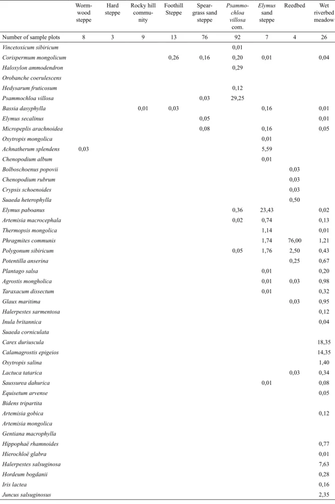
Figure 4. Map of the Khomyn Tal vegetation types. Table 1. (4th part)
Worm-wood steppe
Hard steppe
Rocky hill
commu-nity
Foothill Steppe
Spear-grass sand
steppe
Psammo-chloa villosa
com.
Elymus
sand steppe
31,282 ha representing 11.14% of the Khomyn Tal plant community area, and xeric types cover 249,470 ha, representing 88.86 %.
Mesic types
Reedbed (1,159 ha). The reedbeds of our site consist of almost monospecifi c stands of Phragmites communis, whose height is sometimes more than three meters. This type corresponds to the Phragmitetum communis of Hilbig (1995). They are located along the shores of the lakes in the west of Khomyn Tal.
According to our mapping we have 1,159 ha of reedbeds. Such surfaces, not common in the Gobi according to von Wehrden et al. (2009), are explained by the proximity of vast lakes that create very unique habitats.
Wet riverbed meadow (21,353 ha). Calamagrostis epigeios and Carex duriuscula
are the main species of this meadow type community. The corresponding plots are located in the sandy Zavkhan valley and on the shores of Baga Lake. It has some similarities with the
Halerpestidi-Hordeetum brevisubulati of Hilbig (1995), notably by the rosette plants Halerpestes salsuginosa, Potentilla anserina, Triglochin palustre and the graminoids Juncus salsuginosus
and Carex duriuscula. However, the dominance of Calamagrostis epigeios makes it distinct.
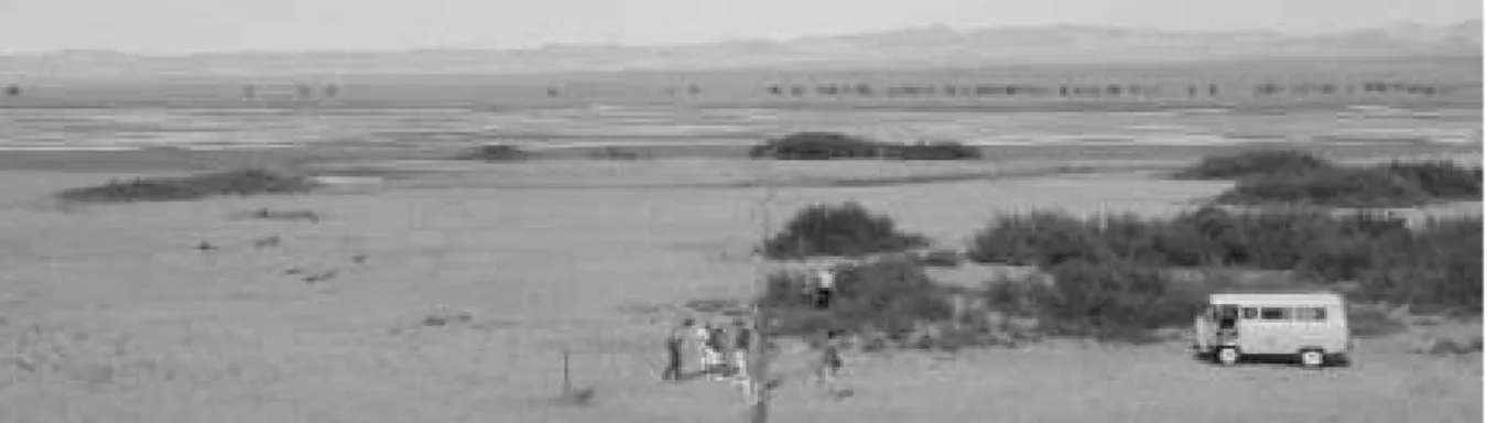
The TWINSPAN analysis included two plots where small trees had a signifi cant cover. One plot had a cover of 20% of the thorny
Hippophaë rhamnoides tree, while the willows
Salix ledebouriana and Salix microstachya
represented 35% of the cover in the second plot. In addition, in the fenced release site of the Przewalski’s horses, many groves of Hippophaë rhamnoides or Salix ssp. are present, sometimes in association. In the northern part of the release site, we visually estimated the woody cover at 75% (Fig. 5). Lastly, we observed upstream in the Zavkhan River that the islets inaccessible to livestock are covered by Hippophaë rhamnoides
and Salixssp.
We therefore think that the meadow found in the Zavkhan riverbed is the result of grazing
Types returned by the classifi er
Field ‘fast plots’ vegetation type (code corresponding to 1st column)
1 2 3 4 5 6 7 8 9 10
Wormwood steppe (1) 33
Bare ground (2) 15 3 1
Hard steppe (3) 71
Foothill steppe (4) 42 1 2 8
Psammochloa villosa community (5) 8 7 244 7 8 3 44
Reedbed (6) 11
Rocky hill community (7) 3 3 11 2
Wet riverbed meadow (8) 2 49
Elymus sand steppe (9) 2 38
Speargrass sand steppe (10) 1 1 3 176
Total fast plots: 799; Total properly classifi ed: 690; Overall accuracy: 86.36 % Table 2. Confusion matrix.
and that the local climax vegetation would be a forest with Hippophaë rhamnoides and Salix ssp. in the upper layer, such as the forests found in the nearby protected areas. This corresponds to the situation in the rest of Mongolian fl oodplains where centuries of grazing replaced woodlands with meadows (Hilbig, 1995).
Elymus sand steppe (8,770 ha). This vegetation type is located close to the west lakes in sandy substrate, and is dominated by
Elymus paboanus and Achnatherum splendens. The presence of Phragmites communis
and Achnatherum splendens indicates the proximity of the groundwater table (Hilbig, 1995), qualifying it as mesic. It is close to the
Glycyrrhizo uralensis-Achnatheretum splendentis
described by Hilbig (1995), but the dominance of
Elymus paboanus makes it distinct.
Xeric types
Hard steppe (21,542 ha). The hard steppe is located in the north of Khomyn Tal, and is dominated by Anabasis brevifolia and
Reaumuria soongorica, mixed with the grass
Stipa glareosa/gobica. Its soil substrate is made of fi ne particles mixed with gravels. This vegetation type perfectly corresponds to the Stipo glareosae-Anabasetum brevifoliae, Reaumuria soongorica sub-association described by Hilbig (1995) and von Wehrden (2009).
Psammochloa villosa community (139,827 ha). The Psammochloa villosa community is located in the south of Khomyn Tal on loose sand. It is the largest community type and covers almost half of the study site (49.80%).
The rhizomatous high grass Psammochloa villosa is sometimes mono-dominant, the only other species with a mean cover above 1% is the
Artemisia klementzae shrub. This type is very close to the Psammochloa villosa community described by Hilbig (1995) and von Wehrden (2009).
Speargrass sand steppe (74,649 ha). This community is located in the center of Khomyn Tal, and sporadically around the Seer range. It stretches between the Hard steppe and the
Psammochloa villosa community. We did not fi nd direct match with previous vegetation descriptions, though it resembles a Hilbig’s (2005) Allio polyrrhizi-Stipetum glareosae
without Allium polyrrhizum.
A particularity of this Speargrass sand steppe is the presence of Artemisia klementzae, which
is also present in the Psammochloa villosa
community. This community might therefore be a transition type between the Stipo glareosae-Anabasetum brevifoliae of the north of Khomyn Tal and the Psammochloa villosa community in the south. Another supporting argument for this is the gradient in substrate particles size. In the north of the community particle size is very similar to that of the Hard steppe, but becomes smaller and smaller in the south until becoming loose sand in the Psammochloa villosa
community. Soil therefore presents intermediate features between the two types.
Foothill steppe (4,475 ha). This community is dominated by Stipa glareosa/gobica,
Caragana leucophloea and Allium mongolicum. It is only located in the foothill of Seer where it might benefi t from the runoff of the neighboring hills. It corresponds to the Oxytropidi aciphyllae-Caraganetum leucophloeae of Hilbig (1995) by the presence of the shrubs Caragana leucophloea
and Oxytropis aciphylla, the forb Convolvulus ammanii and the grass Stipa glareosa/gobica. It also fi ts the description of the Oxytropidi aciphyllae-Caraganetum leucophloeae of von Wehrden (2009) by the presence of the shrubs
Caragana leucophloea, Oxytropis aciphylla
and Ajania fruticulosa, the grass Stipa glareosa/ gobica and the onion Allium mongolicum.
Wormwood steppe (6,466 ha). This community is dominated by the 3 shrubs
Artemisia klementzae, Reaumuria soongorica
and Anabasis brevifolia. Stipa glareosa/gobica is sporadically present, as well as Nitraria sibirica. We did not fi nd any correspondence of this association with previous vegetation descriptions in the literature. The surface of this type is not very high, 2.30% of Khomyn Tal, and therefore, its presence might be due to very peculiar habitat circumstances. Soil characteristics might partly explain this community as some present species, such as Salsola abrotanoides and Limonium aureum are alkaline tolerant (Grubov, 2001).
the four of the main species of Foothill steppe,
Stipa glareosa/gobica, Eurotia ceratoides and
Caragana leucophloea, are also abundant in this community.
Discussion
We classifi ed and mapped the vegetation types with an accuracy of 86.36%, which is more precise than a previous analysis without band modifi cation of the satellite images. Without this treatment, accuracy was 80.77% (Joly et al.,
2011).
The data set of 2006 used in this mapping did not allow separating Stipa glareosa from
Stipa gobica because very few seeds were present. However, since then we regularly visited Khomyn Tal and most of the seeds found were of Stipa glareosa. Stipa gobica was only found on a patch of Speargrass sand steppe at the Seer foothill. This patch must be slightly moister than the rest of the community as it benefi ts from the runoff from neighboring hills. This observation is consistent with previous descriptions that found that Stipa gobica needs more favorable water conditions than Stipa glareosa (von Wehrden
et al., 2006; 2009), and that Stipa glareosa is the most widespread in the desert-steppes of Mongolia (Hilbig, 1995).
The mapping showed that 88.86% of the site is made of 6 xeric types. In the vast Psammochloa villosa community, the eponym species is predominant, and in the 5 remaining communities, among the species with a signifi cant cover, Stipa glareosa/gobica is the most nutritious according to literature (Jigjidsuren & Johnson, 2003). From a forage viewpoint, the xeric area can therefore be separated into Psammochloa villosa and Stipa ssp.
zones.
The remaining 11.14% of Khomyn Tal is made of mesic types that are connected to the water table or lake shores. In the case of drought they have a more reliable access to water so that their primary production variation is supposedly lower than in the neighboring drylands. In addition, we have observed a signifi cant impact of herbivory on the vegetation structure in the riverbed, which covers 7.61% of the site. When it is protected from livestock, a mixed Hippophae rhamnoides/Salix ssp. woodland develops. Grazing and vegetation are therefore coupled in this community, which puts it in the conditions
of the equilibrium model. Consequently, the riverbed corresponds to the defi nition of a key resource area, and thus, from a spatial viewpoint, at least 7.61% of Khomyn Tal surface behaves according to the equilibrium model.
Calculating this percentage is a fi rst step in identifying the limit between equilibrium and non-equilibrium in our study site. The response to grazing of the rest of mesic vegetation types and neighboring drylands remains to be described, to fi nish calculating the area in equilibrium with livestock. In addition, to treat the temporal viewpoint, we need more information on livestock dynamics. In particular, we must assess the capacity of our mesic types to produce enough forage to become a signifi cant factor of livestock number fl uctuations, and the capacity of pastoralists to be mobile enough to utilize all of them. A precise knowledge of breeding and herding practices of our site is therefore necessary to continue investigating the threshold between equilibrium and non-equilibrium models in this site.
Acknowledgments
This research was carried out by the “Association pour le cheval de Przewalski: TAKH” NGO in the framework of a project on co-existence of sympatric wild and domestic ungulates in Khomyn Tal. This project is mainly funded by the ‘MAVA Fondation pour la nature,’ and we thank the foundation for its long-term fi nancial support. We also thank B. Munkhbaatar, B. Otgonsuren, D. Battsooj and T. Odonkhuu, students of Khovd University, for their help in collecting vegetation data. We fi nally thank Dr. D. Oyunchimeg for her help in identifying plant species, and the Khovd University Director. Dr. J. Vanchinkhuu for the fruitful cooperation.
References
Ellis, J. E. & Swift, D. M. 1988. Stability of African pastoral ecosystems: Alternate paradigms and implications for development.
Journal of Range Management, 41: 450-459. Fernandez-Gimenez, M. E. & Allen-Diaz, B.
1999. Testing a non-equilibrium model of rangeland vegetation dynamics in Mongolia.
Mongolia (with an atlas), (Volume I and II)
Science Publishers Inc., Enfi eld.
Herrick, J.E., Van Zee, J.W., Havstad, K.M., Burkett, L.M. & Whitford, W.G. 2005.
Monitoring Manual for Grassland, Shrubland and Savanna Ecosystems. USDA-ARS Jordana Experimental Range, Las Cruces NM.
Hilbig, W. 1995. The Vegetation of Mongolia. SPB Academic publishing bv, Amsterdam. Hill, M. O., Bunce, R. G. H. & Shaw, M. W.
1975. Indicator species analysis, a divisive polythetic method of classifi cation, and its application to a survey of native pinewoods in Scotland. Journal of Ecology, 63: 597-613. Illius, A. W. & O’ Connor, T. G. 1999. On the
relevance of nonequilibrium concepts to arid and semiarid grazing systems. Ecological Applications, 9: 798-813.
IUCN, 2011. IUCN Red List of Threatened Species. Version 2011.2. <www.iucnredlist. org> Downloaded on 01 March 2012.
Jigjidsuren, S. & Johnson, D. A. 2003. Forage Plants in Mongolia. Editor Ch. Sanchir, Ulaanbaatar.
Joly, F., Saïdi, S., Tulganyam, S., King, S. R. B. & Feh, C. 2011. Forage resource utilization in Mongolia, Two concepts frequently applied in range ecology. In Kammili, T., Hubert, B., Tourrand, J. F. (eds.): A Paradigm Shift in Livestock Management: from Resource Suffi ciency to Functional Integrity. 28th and 29th June 2008, Hohhot, China, Cardère éditeur, Lirac, pp. 57-70.
Krishna Bahadur, K. C. 2009. Improving Landsat and IRS Image Classifi cation: Evaluation of Unsupervised and Supervised Classifi cation through Band Ratios and DEM in a Mountainous landscape in Nepal. Remote Sensing, 1: 1257-1272.
Millennium Ecosystem Assessment, 2005.
Ecosystems and Human Well-being:
Desertifi cation Synthesis. World Resources Institute, Washington, DC.
Okayasu, T., Okuro, T., Undarmaa, J. & Takeushi, K. 2011. Threshold distinction
between equilibrium and nonequilibrium pastoral systems along a continuous climatic gradient. Rangeland Ecology and Management, 64: 10-17.
Panda, S. S., Ames, D. P. & Panigrahi, S. 2010. Application of Vegetation Indices for Agricultural Crop Yield Prediction Using Neural Network techniques. Remote Sensing, 2: 673-696.
Scoones, I. 1995. Living with Uncertainty.
Intermediate Technology Publications, London.
Suttie, J. M., Reynolds, S. G. & Batello, C. 2005.
Grassland of the World, FAO, Roma.
Tsegmid, S. & Vorobev, B. B. 1990. National Atlas of the People’s Republic of Mongolia. Academy of Sciences of the People’s Republic of Mongolia, Ulaanbaatar.
Tso, B. & Mather, P.M. 2001. Classifi cation Methods for Remotely Sensed Data. Taylor and Francis, London.
Vetter, S. 2005. Rangelands at equilibrium and non-equilibrium: recent developments in the debate. Journal of Arid Environments, 62: 321-341.
von Wehrden, H., Wesche, K. & Tungalag, R. 2006. Plant communitites of the Great Gobi B Strictly Protected Area, Mongolia. Mongolian Journal of Biological Sciences, 4: 3-17. von Wehrden, H., Wesche, K. & Miehe, G. 2009.
Plant communities of the southern Mongolian Gobi. Phytocoenologia, 39: 1-47.
Wesche, K. & Retzer, V. 2005. Is degradation a major problem in semi-desert environments of the Gobi region in southern Mongolia?.
Erforschung Biologischer Ressourcen der Mongolei, 9: 133-146.
Wesche, K., Miehe, S. & Miehe, G. 2005 Plant communities of the Gobi Gurvan Sayhan National Park (South Gobi Aymak, Mongolia). Candollea,60: 149-205.
Zimmerman, G.M., Goetz, H. & Mielke, P.W. 1985. Use of an improved statistical method for group comparisons to study effects of prairie fi re. Ecology, 66: 606–611.