doi:10.5194/cp-12-1435-2016
© Author(s) 2016. CC Attribution 3.0 License.
Constant wind regimes during the Last Glacial Maximum and
early Holocene: evidence from Little Llangothlin Lagoon, New
England Tablelands, eastern Australia
James Shulmeister1, Justine Kemp2, Kathryn E. Fitzsimmons3, and Allen Gontz4,a
1School of Geography, Planning and Environmental Management, University of Queensland, St. Lucia 4072, Queensland,
Australia
2Australian Rivers Institute, Griffith University, Nathan 4111, Queensland, Australia
3Department of Human Evolution, Max Planck Institute for Evolutionary Anthropology, Deutscher Platz 6, 04103 Leipzig,
Germany
4School for the Environment, University of Massachusetts Boston, Boston, MA 02125, USA
acurrent address: Department of Geological Sciences, San Diego State University, San Diego, CA 92182, USA
Correspondence to:James Shulmeister ([email protected])
Received: 24 March 2016 – Published in Clim. Past Discuss.: 6 April 2016 Accepted: 2 June 2016 – Published: 5 July 2016
Abstract.Here we present the results of a multi-proxy
in-vestigation – integrating geomorphology, ground-penetrating radar, and luminescence dating – of a high-elevation lunette and beach berm in northern New South Wales, eastern Aus-tralia. The lunette occurs on the eastern shore of Little Llan-gothlin Lagoon and provides evidence for a lake high stand combined with persistent westerly winds at the Last Glacial Maximum (LGM – centring on 21.5 ka) and during the early Holocene (ca. 9 and 6 ka). The reconstructed atmospheric cir-culation is similar to the present-day conditions, and we infer no significant changes in circulation at those times, as com-pared to the present day. Our results suggest that the South-ern Hemisphere westerlies were minimally displaced in this sector of Australasia during the latter part of the last ice age. Our observations also support evidence for a more positive water balance at the LGM and early Holocene in this part of the Australian sub-tropics.
1 Introduction
The temperate-latitude westerly wind system influences the southern half of the Australian continent and dictates not only this region’s climate but also the formation and response of its landscape systems. It plays an important role in the de-livery of winter rainfall to the southern half of Australia.
Un-derstanding the history of the westerlies in the Australasian region is therefore important for understanding the climate and environmental history of eastern Australia (Shulmeister et al., 2004; Fletcher and Moreno, 2012; Lorrey et al., 2012). In addition, changes in the Southern Hemisphere westerlies are inferred to modulate global atmospheric carbon dioxide concentrations and potentially trigger global climate changes (e.g. Denton et al., 2010).
Here we investigate past wind regime changes in eastern Australia as reflected in the shoreline marginal landforms of Little Llangothlin Lagoon (LLL). LLL is a presently
shal-low lake which sits at 30◦S (30◦5′9′′S, 151◦46′53′′E) in
investiga-Catchment divide
Berm
Lunette
Poorly sorted silty medium sand Well sorted coarse sand Coarse sand with pisolithic gravel Permanent or ephemeral lake
Poorly sorted fine sand with accessory silt Poorly sorted medium sand with accessory silt Sandy lunette Sand and gravel berm
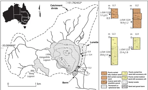
Figure 1.Geomorphology and sediments at Little Llangothlin Lagoon (30◦5′9′′S, 151◦46′53′′E), 18 km NE of Guyra, NSW, showing the
locations of GPR transects, sediment cores (right), and the position of OSL samples.
tions, to reconstruct past periods of westerly, and possible north-westerly, prevailing wind flow in this region.
The endorheic LLL basin was formed in gently undulating tableland comprising Tertiary basalt flows at approximately 1300 m above mean sea level (a.m.s.l.). The western shore-line of LLL is dominated by a low ridge of basalt, which rises 30 m above the lake (Fig. 1). On the eastern side of the basin, the lake is bound by a low hill of granite that forms part of the New England Batholith (Shaw and Flood, 1981). The lagoon
covers an area of 1.2 km2and has a catchment of 3.2 km2.
LLL is a shallow, roughly circular permanent lake with a maximum depth of 2 m that shallows during droughts, which in this part of Australia are often associated with El Niño years. As far as we can determine, the lake has never dried out fully in post-European settlement times (Woodward et al., 2014b). Another, smaller, lake (Billy Bung Lagoon) lies ca. 500 m to the south-west of LLL and is separated from the main lake by the low basalt ridge.
The origin of the New England “lagoons” is cryptic. Con-raeds (1989) showed that they were associated with former drainage lines that were occupied by basalt flows. He sug-gested that uneven infilling of former valleys by basalt during the Tertiary produced shallow depressions where the shal-low lakes and swamps, locally called lagoons, formed. Simi-lar lakes have been described elsewhere along the tablelands of the Great Dividing Range, and Ollier (1979) suggested a tectonic origin for these features, proposing that uplift of the Eastern Highlands caused back tilting on many streams. Other authors such as Bell et al. (2008) have suggested a deflationary origin, where intense weathering occurred as a result of wetting and drying of the basalt. The mechanisms
are not incompatible, and deflation may have enhanced and maintained the basins, which were created by back tilting.
Many of these upland lakes have lunettes on their east-ern margins (sensu Bowler, 1976). These are transverse cres-centic ridges dominated by wave action and shoreline drift, with coarse-textured wave-built ridges on downwind margins (Bowler, 1986). Their regular outline reflects the influence of strong wave action, while the aeolian deflation of sands from the beach forms foreshore dunes with an orientation consis-tent with the winter wind resultant vector (Bowler, 1971). The proportion of clay and silt in lunettes increases during periods of shoreline regression and is derived from efflores-cence and pelletisation of saline lacustrine sediments on the drying lake floor. Salt concentration in upland lakes tends to be weaker owing to groundwater seepage, restricting the preparation of pelletal clays for deflation and producing dom-inantly sandy lunettes.
The catchment is fed by summer rainfall (mean annual
rainfall= 880 mm) and has a theoretical net annual
mois-ture balance deficit of ca. 400 mm (Woodward et al., 2014a). The regional vegetation is dominated by montane open eu-calypt woodland, while the lagoon itself contains extensive
beds of tall spike rush (Eleocharis sphacelata) and the
wa-ter plantPotamogeton tricarinatusin the deeper parts of the
basin. Other swamp plants, includingCarex gaudichaudiana,
chal-lenged (Woodward et al., 2011). The site has more recently become a focus for work due to inferred changes to basin hydrology in response to tree clearance during European set-tlement of the New England Tablelands (Woodward et al., 2014a). There has also been some investigation of the ar-chaeological history of the lagoon suggesting that landscapes such as these provided relatively rich resources for Aborigi-nal people and that New England lagoons became the foci for ceremonial activities, although the degree to which hydro-logical conditions influenced human activity remains poorly understood since chronological control for the pre-European period has so far been lacking (Beck et al., 2015).
This paper examines the geomorphic context of shoreline features on the western and southern margins of the lagoon and focuses on the history of lake-margin sediment depo-sition to reconstruct the climatic circulation from the Last Glacial Maximum (LGM) into the Holocene.
2 Materials and methods
2.1 Field investigations
Transects across an apparent beach berm and the lunette were surveyed using a MALÅ ProEx ground-penetrating radar (GPR) system with a 500 MHz antenna and integrated high-resolution GPS. The GPR data were collected in tran-sects forming a rough grid parallel and perpendicular to the trend of hypothesised beach and lunette landforms. The
GPR was hand-dragged at a speed of∼4 kph and fired
us-ing time firus-ing at a rate of 10 Hz, resultus-ing in an average along-track resolution of 0.11 and 0.07 m vertical resolution, based on a centre frequency of 500 MHz. After acquisition, radar data were processed using GPR-SLICE software (DC
drift; user-defined signal gain; bandpass lo= 350 MHz, hi
=650 MHz; background removal). Profiles were
topograph-ically corrected using elevation data from the GPS system and spot-checked using known elevations. While absolute to-pography was not reliable, relative elevation was consistently reproducible. Individual profiles were converted to depth– distance using the published radar velocity for wet sands of
0.07 m ns−1in the beach ridges and dry sands of 0.12 m ns−1
in the lunette (Neal, 2004). Depth–distance profiles were used to evaluate sediment thickness and observe true geome-try of radar reflectors.
The sub-surface sediments were logged using a hand auger to a depth of between 0.6 and 1.2 m, depending on sub-surface conditions. Sub-samples were collected for grain size analyses. In addition, gravels from the sand and gravel barrier were treated with HCl for 12 h in order to identify weather-ing products such as manganese–iron pisoliths. Four samples were collected for optically stimulated luminescence (OSL) dating using steel tubes, wrapped in black plastic, and trans-ported to the Max Planck Institute for Evolutionary Anthro-pology in Leipzig for analysis.
2.2 OSL dating – equivalent-dose measurements
Sample preparation and measurement for OSL dating were undertaken in the luminescence dating laboratory of the De-partment of Human Evolution, Max Planck Institute for Evo-lutionary Anthropology in Leipzig. The OSL samples were prepared under subdued red light using published methods (Fitzsimmons et al., 2014). This involved sieving, applying HCl acid and hydrogen peroxide digestion to remove carbon-ates and organic matter respectively; and isolating pure, 180–
212 µm quartz grains. The outer ∼10 µm alpha-irradiated
rind of each grain was removed by etching in hydrofluoric acid, and the sample was then subjected to a final sieve to remove finer fragments which had broken off during etching. The quartz grains were then prepared as small aliquots (18 discs; 1 mm diameter) for preheat testing and as single grains
(600 grains; six single-grain discs) for equivalent-dose (De)
measurement.
De measurements were undertaken using an automated
Risø TL-DA-15 equipped with blue-light-emitting diodes (for preheat and initial dose estimate testing) and a TL-DA-20 reader with a single-grain attachment containing a green laser emitting at 532 nm, for light stimulation of sin-gle aliquots and sinsin-gle grains respectively (Botter-Jensen et
al., 2000). Irradiation was provided by calibrated90Sr/90Y
beta sources. Equivalent doses were determined on single grains using the single aliquot regenerative dose (SAR) pro-tocol of Murray and Wintle (2000, 2003). Preheat
tempera-tures of 260◦C were chosen based on the results of the
pre-heat plateau tests (Fig. S2 in the Supplement) for the natural
and regenerative doses, with a preheat temperature of 220◦C
for the test doses (0.94 Gyr).
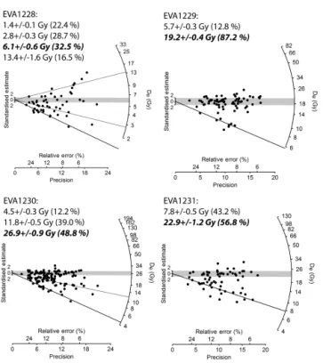
Individual grains were analysed for their suitability for OSL dating based on the selection criteria of Jacobs and Roberts (2007). The single-grain dose distributions of all samples are > 40 % overdispersed with complex dose pop-ulations (Table S1 in the Supplement), and therefore the fi-nite mixture model (FMM) was used to identify dose popu-lations (Galbraith and Green, 1990). The OSL dating results are summarised in Table 1. Equivalent-dose distributions for the four samples are shown as radial plots, with the FMM-derived dose populations highlighted, in Fig. 3.
2.3 OSL dating – dose rate calculations
Uranium, thorium, and potassium (40K) activities were
mea-sured in the “Felsenkeller” laboratory at VKTA Rossendorf in Dresden, Germany, using low-level gamma-ray spectrom-etry. Dose rates were calculated using the conversion
fac-tors of Stokes et al. (2003) withβ-attenuation factors taken
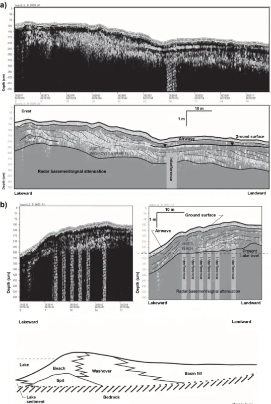
Figure 2.(a)GPR transects over the “berm”. See Fig. 1 for location of transect. GPR line A7 was acquired perpendicular to the shoreline
starting just lakeward of the highest point on the berm. Internal structures are characteristic of an interfingering beach–wash-over–basin fill sequence over a spit complex. Upper panel, raw data; lower panel, interpretation.(b)GPR line A9 was acquired from the lake shore to the
Table 1.Equivalent dose (De), dose rate data, and OSL age estimates for Little Llangothlin Lagoon. Dose rates are listed as attenuated based on published factors (Stokes et al., 2003; Mejdahl, 1979).
Sample De(Gyr) K(%) Th (ppm) U(ppm) Beta dose Cosmic dose Water Total dose Age (ka) rate (Gy ka−1) rate (Gy ka−1) content (%) rate (Gy ka−1)
L-EVA 1228 (LL1) 6.1±0.6 0.53±0.02 4.0±0.2 1.3±0.1 0.6±0.1 0.19±0.02 10±3 1.21±0.07 5.1±0.5 L-EVA 1229 (LL2) 19.2±0.4 0.34±0.02 3.5±0.2 1.3±0.1 0.5±0.1 0.18±0.02 5±3 1.02±0.06 18.9±1.2 L-EVA 1230 (LL3) 26.9±0.9 0.69±0.04 3.0±0.1 1.3±0.1 0.7±0.1 0.18±0.02 7±3 1.30±0.08 20.6±1.4 L-EVA 1231 (LL4) 22.9±1.2 0.56±0.02 2.7±0.1 0.7±0.1 0.5±0.1 0.18±0.02 6±3 0.98±0.05 23.4±1.8
Figure 3.Equivalent-dose distributions for the LLL samples,
illus-trated as radial plots. The shaded populations in each case represent the dominant age peaks; the lines illustrate the other identified pop-ulations.
3 Results
3.1 Geomorphology
There are no dune or beach deposits on the western side of the lake (Fig. 1). The main geomorphic feature on the eastern side of the lake is the lunette and the low basalt ridge. The lunette comprises a north–south-oriented ridge less than 2 m high adjacent to the lake, a swale behind that is occupied by a small stream, and a small sand flat area that extends up to 50 m east of the lake shore.
The lunette on the eastern shore is composed of poorly sorted medium sand grading upwards into fine sand with ac-cessory silt contents of 3–15 %. Particle size results and other stratigraphic information are plotted in Fig. 1, and particle
size analysis curves are provided in Fig. 1 of the Supplement. GPR transects are shown in Fig. 2a and b.
On the SE margin of LLL, there is a partly infilled out-let, immediately to the west of which there is a ca. 100 m long, 50 m wide low (< 1 m) berm. The berm is poorly to well sorted and has medium and coarse quartz-rich sand with iron–manganese, pisolithic gravel, and a silt content of 1– 14 %.
3.2 GPR results
The GPR proved effective at mapping stratigraphic architec-ture and sub-surface character to a depth shallower than 4 m in the berm (Fig. 2a and b). GPR data suggest the presence of several distinct units related to changes in lake level and the development of spit/barrier and berm formations (Shan et al., 2015; Thompson et al., 2011). The berm showed strong internal stratification and features perpendicular lines with strong sigmoidal clinoforms indicating beach progradation to the west (Thompson et al., 2011) as well as low-angle sub-parallel reflectors dipping to the east suggesting basin infill via over wash processes. This package is underlain by a convex-up package of reflections that are sub-parallel with dips to the east and west. Comparison of this feature with those identified by Shan et al. (2015) suggests the complex is underlain by a spit complex. Additional information on the character of the lower units associated with the interpreted spit are unavailable due to the existing GPR data coverage.
3.3 OSL results
The OSL age data are summarised in Table 1 and shown with respect to stratigraphy and catchment geomorphology in Fig. 1. The three samples collected from three different locations along the lunette suggest that the entire landform was active during the LGM, between ca. 24 and 19 ka. Our samples do not extend to the base of aeolian sedimentation, and it is likely that the lunette was formed earlier than the LGM. The secondary age populations identified by FMM are all younger than the LGM phase of deposition (Fig. 3; Table S2) and suggest phases of partial reactivation or pe-dogenic infiltration of material into the lunette. The younger age populations from sites LL3 and LL4 in the central part of the lunette are comparable and strongly suggest contem-poraneous post-depositional infiltration of younger material or partial reactivation of the lunette in the early Holocene (ca. 9–8 ka; Table S2). Sample L-EVA 1230 (LL3) exhibits a third peak centred on 11.8 Gy BP (9.1 ka). The second ma-jor age population from the LL2 site in the southern part of
the lunette dates to the mid-Holocene (5.6±0.5 ka; Table S2)
and suggests spatial and temporal variability in the Holocene post-depositional pedogenesis (or reactivation) of the lunette.
The overdispersion on individualDeresults from the berm
was too high (79.9 %; Table S1) to reliably define a deposi-tional age, although the largest age population yields a
mid-Holocene age (5.1±0.5 ka; Table 1) comparable with the
re-activation of the southern part of the lunette at LL2. The
mi-nor dose populations yield ages of 11.1±1.6, 2.3±0.3 and
1.2±0.1 ka (Table S2).
4 Discussion
There are two separate but related sets of geomorphic fea-tures recorded along the eastern and south-eastern margin of LLL. These are the sand and gravel berm, which is a lake beach/spit feature, and the lunette, which is an aeolian fea-ture but tied to the shoreline. Both are supplied with sedi-ment by wind wave processes in the lake, but the former is a sub-aqueous feature, while the lunette is an aeolian structure.
4.1 A possible spit/barrier berm in the SE corner of the lagoon
The most cryptic landform in the basin is the sand and gravel berm on the SE margins of LLL. The feature was identified by Gale and Haworth (2005), who interpreted it as part of a relict older lunette feature. From visual observations alone, this is a reasonable interpretation because the low berm does look like the erosional shadow of an older ridge. Our sedi-mentologic and GPR structural investigations, however, dis-count this interpretation. Based on both GPR and field obser-vations from pits, the feature is clearly a beach berm, with numerous small wash-over structures (see Fig. 2a).
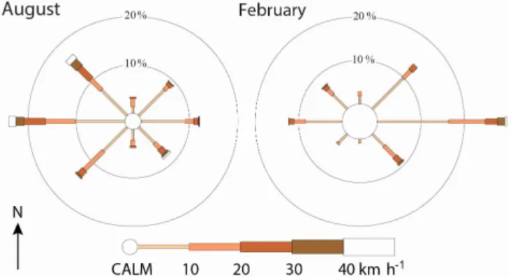
Figure 4.Rose of 09:00 wind direction vs. wind speed in km h−1
at Guyra Hospital, 1332 m a.m.s.l. (Bureau of Meterology, 2014). Only winds above∼22 kph are sand-carrying (based on the 12-knot threshold of Fryberger, 1979). Sand drift potential is much stronger in winter (August) than it is in summer (February) because the re-lationship is a power function of the wind speed and frequency of very strong winds is much lower in summer.
The berm barrier feature is composed of pea-sized grav-els within a finer sandy matrix. We assume the sandy ma-trix to be post-depositional because it is incompatible with the sedimentary structures and post-depositional infilling of openwork deposits is common. In addition, the contrast be-tween locally sourced detrital basalt gravels and reworked quartz-rich sand and silt is striking. The matrix may have accumulated either through aeolian accession or through fil-tration of sands through the barrier during high lake stands when the berm would have acted as a permeable filter for the lake. Given the mostly coarse nature of the matrix (medium to coarse sand), we prefer the two-stage filtration hypothesis. The pea-sized gravels are detrital. We suggest that the most likely origin for this feature is as a spit that devel-oped from the basalt ridge on the SW edge of the lake and that the basalt gravels were moved along the shoreline by longshore drift. The barrier ultimately cut off an area to the SW of the present lake that was part of a larger, ances-tral lake feature, for which we have no age constraint due to the lack of associated sedimentary deposits. The barrier post-dates the LGM as we have been provided with a radio-carbon result (R. Haworth, personal communication, 2016) from a depth of 1.5 m close to our LL1 sample (Beta-110588:
16 200±70 yr BP; median: 19 500 cal yr BP; calibration from
4.2 Aeolian history of LLL from the lunette
Based on the morphology, sedimentary composition, and in-ternal structure, the feature along the eastern shoreline of LLL is clearly a composite beach and aeolian landform. The quartz-rich sands were most likely derived from the granites on the eastern side of the catchment, which deposited into the lake and were subsequently reworked onto the shore-line. Half the basin is comprised of basalt, yet there is lit-tle evidence for basalt-derived sediments in the lunette sys-tem. By contrast, the fine sediments in the depocentre of the lake basin are primarily derived from basalt. This implies that there is an effective sorting mechanism within the basin, whereby the basalt preferentially weathers to mud while the granite generates sand. Sorting by currents would transport the fines to the depocentre, while the sands would be trans-ported towards the lake margins. The most parsimonious can-didate for this latter process is wind-blown waves.
Present-day wind roses for LLL (BOM, 2014) demon-strate that there are two primary wind directions (Fig. 4), one from the east and the other from the west to north-west. These prevailing winds have strong seasonal components. Winter winds (August) are dominated by westerlies and pro-vide the strongest and most persistent flows (8 % calm) con-sistent with eastward transport and deposition of sediments onto a lunette situated on the eastern shoreline of LLL. Sum-mer winds (February) are dominated by easterlies associated with onshore circulation on the northern limb of the sub-tropical high-pressure cell in summer (Fig. 4). These east-erly winds are on average weaker (20 % calm) but do include short periods of relatively high-intensity winds, which might be expected to result in sediment transport to, and deposi-tion onto, the western side of the lake. It is curious therefore that all depositional landforms marginal to LLL are located on the east and south-east sides of the lake, with no deposi-tion on the western shoreline. Examinadeposi-tion of the wind roses
indicates that sand-transporting winds (above ∼22 km h−1:
Fryberger, 1979) were more than twice as frequent (∼14 %
vs. ∼5 %) in August than in February and that the
high-est wind speeds occurred more frequently in August. This confirms that the most effective net sand-transporting wind, associated with lunette and berm formation, was from the west/north-west. The transport is most likely to have been primarily sub-aqueous, since the relatively poor sorting in the foredune indicates only a short-distance aeolian transport pathway.
In addition to the stronger drift potential there may also be a biological effect. The rush beds occurring in the shal-lower parts of the lake are most fully developed during the summer. Unlike much of Australia, winters are severe on the New England Tablelands due to the relatively high ele-vations, and seasonal die-back of the tall spike rush is ob-served today. New growth emerges in spring and dies off in autumn in cooler, high-altitude sites (Rajapaskse et al., 2006). Consequently, the summer peak in vegetation cover
disrupts the wind fetch over the lake precisely at the same time as the easterly winds penetrate the tablelands, thereby further reducing the ability for waves to set up during the warmer months.
The luminescence ages from the lunette are coherent. All samples are dominated by grains that are LGM in age. The
samples all overlap at 2σ and produce a weighted mean age
of 20.4±0.8 ka, indicating that the main phase of dune
activ-ity at LLL occurred during the late LGM. Our interpretation that the dominant sediment transport mechanism was sub-aqueous therefore implies that the LGM oversaw permanent, and probably full, lake conditions at LLL. Evidence from our unpublished sedimentary archives from the depocentre of the lake supports the concept of a full lake during the late LGM (ca. 19 ka). Specifically, the lake sediments from this time in-terval are an unoxidised grey clay, which contains numerous sponge spicules. In addition, pollen records from these lati-tudes suggest the survival of rainforest at lower elevations to the east through the LGM (e.g. Moss et al., 2013), indicat-ing persistence of moisture availability. Our argument for the persistence, and perhaps intensification, of winter westerlies throughout the LGM at LLL is also confirmed by observa-tions made at North Stradbroke Island some 300 km to the north-north-east of our site (Petherick et al., 2009; McGowan et al., 2008). North Stradbroke Island lies at the very northern edge of the westerlies zone, and the accession of fine aeolian material into a dune lake there indicates that the winter west-erlies were operative at the LGM in South East Queensland
at 27.20◦S (Petherick et al., 2009; McGowan et al., 2009),
just as the westerlies operate today in this region.
A secondary peak in grain ages is observed in all three lunette samples. This peak is less well defined but in all three cases relates to the early to mid-Holocene between 9 and 6 ka. Work from the lake (Woodward et al., 2011) has already demonstrated that the early Holocene was the last phase, be-fore the modern anthropogenically modified lake, with lake
full conditions as represented by extensiveEleocharisbeds.
Wind waves would have been effective on the lake, and we infer partial reactivation of the lunette at this time.
We note a third grain age peak in one lunette sample (EVA1230) at ca. 3 ka. This is both the weakest individual age peak and not replicated at any other site. It is possible that this represents a dune re-activation event; bioturbation; or even Aboriginal usage of the site, which has been pro-posed to have intensified during the late Holocene (post 4300 years; Beck et al., 2015). At this stage this event, if real, is still poorly controlled chronologically, and we do not inter-pret it further.
the Pleistocene, elevations above 800 m in the region were subject to extensive, active development of block deposits, screes, and solifluction lobes, indicating winter cooling of at
least 10.5◦C relative to present (Slee and Shulmeister, 2015).
Reduced evaporation due to lower temperatures (e.g. Hesse et al., 2003) and transfer of flow from throughflow/baseflow to overland flow due to increased snow cover (Reinfelds et al., 2014) at this time are likely to have been sufficient to cause the change to a positive hydrological balance in the lake.
For the intervening periods, at least in the Holocene, the evidence (Woodward et al., 2014a) suggests that water lev-els were lower and/or even that the lake was ephemeral. It is highly unlikely that sand would be transported to the high-stand beach during low lake levels. If the entire basin floor fully dried out, pelletised clays might be expected, and yet none are observed. There are two likely reasons for this. Firstly, this high-elevation site is unlikely to become very arid even during relatively dry phases when swampy con-ditions probably persisted on the basin floor. Similarly, it is unlikely that salt formation is significant in this setting, and clay pelletisation may not occur. This is similar to ob-servations from Lake George, which also lies within a cool temperate climate setting along the Great Dividing Range (Fitzsimmons and Barrows, 2010).
In summary, these records strongly suggest that for the two intervals recorded (the LGM and early Holocene) the overall circulation conditions at LLL were very similar to the present day. This region presently lies near the northern limit of west-erly penetration in winter. For the intervening periods, ab-sence of evidence is not evidence of abab-sence; if the winter westerly winds lay at this latitude during peak warming in the early Holocene and during the LGM, it seems reasonable to suppose that this track has been persistent over the last 25 kyr.
The track of the Australian winter westerlies during the LGM has been a source of contention for some time, with both poleward and equatorward changes argued for (e.g. Har-rison and Dodson, 1993; Hesse, 1994; Shulmeister et al., 2004). One possibility is that the westerly lay north of its current track during the LGM and that the timing of the westerlies at LLL shifted seasonally. A northward shift of
∼3◦(350 km) in the position of the westerly wind belt
dur-ing marine isotope stage (MIS) 2 was recorded in sediments from marine cores in the Tasman Sea (Hesse, 1994). Anal-ysis of the aeolian component of lake sediments on North
Stradbroke Island at 27◦S for the period 25–22 ka indicates
dust sources in the SW Murray–Darling Basin, with a sec-ondary component from WNW of the site (Petherick et al., 2009). These findings are consistent with either no change or a possible northward shift in the westerlies but are not consis-tent with the poleward contraction of the westerlies in eastern Australia at the LGM.
5 Conclusions
This study indicates that westerly winds activated a lunette at LLL during the LGM under the influence of high lake lev-els. This ridge was reactivated during high lake stands in the early to mid-Holocene. The persistence of westerly winds at this site during the LGM confirms observations from North Stradbroke Island at the northern limits of penetration of the temperate-latitude westerlies. This suggests that the overall circulation pattern in this part of eastern Australia, at the modern northern limits of westerly winter flow, remained constant during both the LGM and the early Holocene. Over-all, this points to minimal change in circulation patterns over the last 25 kyr.
6 Data availability
Summary statistics for rainfall and temperature data from the
Guyra Hospital weather station (30.21◦S, 151.68◦E; 1329 m
elevation) from 1981 to 2016 and for other climatic vari-ables including wind speed and direction for the period from 1981 to 2010 (see http://www.bom.gov.au/climate/averages/ tables/cw_056229.shtml).
The Supplement related to this article is available online at doi:10.5194/cp-12-1435-2016-supplement.
Author contributions. James Shulmeister led the project,
as-sisted with field sampling for OSL and grain size, and led the manuscript development. Justine Kemp assisted in the field with OSL sample acquisition, conducted grain size analysis, and partic-ipated in manuscript development. Kathryn E. Fitzsimmons under-took the OSL sample analysis and participated in manuscript devel-opment. Allen Gontz led the GPR acquisition and processing and assisted with OSL sampling and manuscript development.
Acknowledgements. This research was funded by Australian
Research Council Discovery Grant DP110103081, “The last glacia-tion maximum climate conundrum and environmental responses of the Australian continent to altered climate states”. We thank S. Hesse for assistance with OSL sample preparation. R. Haworth made a radiocarbon age from underneath the sand and gravel berm available to us. C. Woodward, J. Chang, and A. Slee assisted with fieldwork. We thank all the referees for very helpful input that has improved the paper. We thank NSW National Parks and Wildlife Service for access to the site and the local farmers for retrieving our vehicle from the bottomless suckhole!
Edited by: A. Lorrey
References
Beck, W., Haworth, R., and Appleton, J.: Aboriginal resources change through time in New England upland wetlands, south-east Australia, Archaeol Ocean., 50, 47–57, 2015.
Bell, D. M., Hunter, J. T., and Haworth, R. J.: Montane lakes (la-goons) of the New England tablelands bioregion, Cunninghamia, 10, 475–492, 2008.
Botter-Jensen, L., Bulur, E., Duller, G. A. T., and Murray, A. S.: Advances in luminescence instrument systems, Radiat. Meas., 32, 523–528, 2000.
Bowler, J. M.: Aridity in Australia: Age, origins and expression in aeolian landforms and sediments, Earth Sci. Rev., 12, 279–310, 1971.
Bowler, J. M.: Clay Dunes: Their occurrence, formation and environmental significance, Earth Sci. Rev., 9, 315–338, doi:10.1016/0012-8252(73)90001-9, 1973.
Bowler, J. M.: Aridity in Australia: age, origins and expression in aeolian landforms and sediments, Earth Sci. Rev., 12, 279–310, 1976.
Bowler, J. M.: Lunettes as indices of hydrologic change: a review of Australian evidence, Proc. R. Soc. Victoria, 95, 147–168, 1983. Bowler, J. M.: Spatial variability and hydrologic evolution of
Aus-tralian lake basins: analogue for Pleistocene hydrologic change and evaporite formation, Palaeogeogr. Palaeoclim. Palaeoecol., 54, 21–41, 1986.
Bureau of Meteorology: Summary statistics Guyra Hospital, Climate Data Online, available at: http://www.bom.gov.au/ climate/averages/tables/cw_056229.shtml (last access: 29 Febru-ary 2016), 2014.
Coenraads, R. R.: Evaluation of the natural lagoons of the Central Province, NSW – Are they sapphire-producing maars?, Explor Geophys., 20, 347–363, 1989.
Denton, G. H., Anderson, R. F., Toggweiler, J. R., Edwards, R. L., Schaefer, J. M., and Putnam, A. E.: The last glacial termination, Science, 328, 1652–1656, doi:10.1126/science.1184119, 2010. Fitzsimmons, K. E. and Barrows, T. T.: Holocene hydrologic
vari-ability in temperate southeastern Australia: An example from Lake George, New South Wales, The Holocene, 20, 585–597, 2010.
Fitzsimmons, K. E., Stern, N., and Murray-Wallace, C. V.: Deposi-tional history and archaeology of the central Lake Mungo lunette, Willandra Lakes, southeast Australia, J. Archaeol Sci., 41, 349– 364, 2014.
Fletcher, M. S. and Moreno, P. I.: Have the Southern Westerlies changed in a zonally symmetric manner over the last 14,000 years? A hemisphere-wide take on a controversial problem, Qua-ternary Int., 253, 32–46, 2012.
Fryberger, S. G.: Dune forms and wind regime, in: A study of global sand seas, edited by: McKee, E. D., Gov print office, Washington, USA, 137–160, 1979.
Galbraith, R. F. and Green, P. F.: Estimating the component ages in a finite mixture, Nucl. Tracks Rad. Meas., 17, 197–206, 1990. Gale, S. J. and Haworth, R. J.: Catchment-wide soil loss from
pre-agricultural times to the present: transport-and supply-limitation of erosion, Geomorphology, 68, 314–333, 2005.
Gale, S. J., Haworth, R. J., and Pisanu, P. C.: The 210 Pb chronology of late Holocene deposition in an eastern Australian lake basin, Quaternary Sci. Rev., 14, 395–408, 1995.
Harrison, S. P. and Dodson, J. R.: Climates of Australia and New Guinea since 18,000 yr B.P, in: Global Climates Since the Last Glacial Maximum, edited by: Wright Jr., H. E., Kutzbach, J. E., Webb III, T., Ruddiman, W. F., Street-Perrot, F. A., and Bartlein, P. J., University of Minnesota Press, Minneapolis, MN, 265–293, 1993.
Hesse, P. P.: The record of continental dust from Australia in Tas-man Sea sediments, Quaternary Sci. Rev., 13, 257–272, 1994. Hesse, P. P., Humphreys, G. S., Selkirk, P. M., Adamson, D. A.,
Gore, D. B., Nobes, D. C., Price, D. M., Schwenninger, J.-L., Smith, B., Tulau, M., and Hemmings, F.: Late Quaternary aeolian dunes on the presently humid Blue Mountains, Eastern Australia, Quaternary Int., 108, 13–32, 2003.
Hogg, A. G., Hua, Q., Blackwell, P. G., Buck, C. E., Guilderson, T. P., Heaton, T. J., Niu, M., Palmer, J. G., Reimer, P. J., Reimer, R. W., Turney, C. S. M., and Zimmerman, S. R. H.: SHCal13 Southern Hemisphere Calibration, 0–50,000 years cal BP, Radio-carbon, 55, 1889–1903, doi:10.2458/azu_js_rc.55.16783, 2013. Jacobs, Z. and Roberts, R. G.: Advances in optically stimulated
lu-minescence dating of individual grains of quartz from archeolog-ical deposits, Evol. Anthropol., 16, 210–223, 2007.
Lorrey, A. M., Vandergoes, M., Almond, P., Renwick, J., Stephens, T., Bostock, H., Mackintosh, A., Newnham, R., Williams, P. W., Ackerley, D., and Neil, H.: Palaeocirculation across New Zealand during the last glacial maximum at∼21 ka, Quaternary Sci. Rev., 36, 189–213, 2012.
McGowan, H. A., Petherick, L. M., and Kamber, B. S.: Aeolian sedimentation and climate variability during the late Quaternary in southeast Queensland, Australia, Palaeogeogr. Palaeocl., 265, 171–181, 2008.
Mejdahl, V.: Thermoluminescence dating: beta-dose attenuation in quartz grains, Archaeometry, 21, 61–72, 1979.
Moss, P. T., Tibby, J., Petherick, L., McGowan, H., and Barr, C.: Late Quaternary vegetation history of North Stradbroke Island, Queensland, eastern Australia, Quaternary Sci. Rev., 74, 257– 272, 2013.
Murray, A. S. and Wintle, A. G.: Luminescence dating of quartz using an improved single-aliquot regenerative-dose protocol, Ra-diat. Meas., 32, 57–73, 2000.
Murray, A. S. and Wintle, A. G.: The single aliquot regenerative dose protocol: potential for improvements in reliability, Radiat. Meas., 37, 377–381, 2003.
Neal, A.: Ground penetrating radar and its use in sedimentology: principles, problems and progress, Earth Sci. Rev., 66, 261–330, 2004.
Ollier, C. D.: Evolutionary Geomorphology of Australia and Papua: New Guinea, T I Brit. Geog., 4, 516–539, 1979.
Petherick, L. M., McGowan, H. A., and Kamber, B. S.: Recon-structing transport pathways for late Quaternary dust from east-ern Australia using the composition of trace elements of long traveled dusts, Geomorphology, 105, 67–79, 2009.
Prescott, J. R. and Hutton, J. T.: Cosmic ray contributions to dose rates for luminescence and ESR dating: Large depths and long term variations, Radiat. Meas., 23, 497–500, 1994.
Reinfelds, I., Swanson, E., Cohen, T., Larsen, J., and Nolan, A.: Hy-drospatial assessment of streamflow yields and effects of climate change: Snowy Mountains, Australia, J. Hydrol., 512, 206–220, 2014.
Shan, X., Yu, X., Clift, P. D., Tan, C., Jin, L., Li, M., and Li, W.: The ground penetrating radar facies and architecture of a paleo-spit from Huangqihai Lake, North China: implications for gene-sis and evolution, Sediment. Geol., 323, 1–14, 2015.
Shaw, S. E. and Flood, R. H.: The New England Batholith, eastern Australia: geochemical variations in time and space, J. Geophys. Res.-Sol. Ea., 86, 10530–10544, 1981.
Shulmeister, J., Goodwin, I., Renwick, J., Harle, K., Armand, L., McGlone, M. S., Cook, E., Dodson, J., Hesse, P. P., Mayewski, P., and Curran, M.: The Southern Hemisphere westerlies in the Australasian sector over the last glacial cycle: a synthesis, Qua-ternary Int., 118, 23–53, 2004.
Slee, A. and Shulmeister, J.: The distribution and climatic implica-tions of periglacial landforms in eastern Australia, J. Quaternary Sci., 30, 848–858, 2015.
Stokes, S., Ingram, S., Aitken, M. J., Sirocko, F., Anderson, R., and Leuschner, D.: Alternative chronologies for Late Quaternary (Last Interglacial–Holocene) deep sea sediments via optical dat-ing of silt-sized quartz, Quaternary Sci. Rev., 22, 925–941, 2003.
Stuiver, M. and Reimer, P. J.: Extended14C data base and revised CALIB 3.014C age calibration program, Radiocarbon, 35, 215– 230, 1993.
Thomas, D. S. G. and Burrough, S. L.: Luminescence-based chronologies in southern Africa: analysis and interpretation of dune database records across the subcontinent, Quaternary Int., 1–16, in press, 2016.
Thompson, T. A., Lepper, K., Endres, A. L., Johnston, J. W., Baedke, S. J., Argyilan, E. P., Booth, R. K., and Wilcox, D. A.: Mid Holocene lake levels and shoreline behaviour during the Nipissing phase of the upper Great Lakes at Alpena, Michigan, USA, J. Great Lake Res., 37, 567–576, 2011.
Woodward, C., Chang, J., Zawadzki, A., Shulmeister, J., Haworth, R., Collecutt, S., and Jacobsen, G.: Evidence against early nine-teenth century major European induced environmental impacts by illegal settlers in the New England Tablelands, south eastern Australia, Quaternary Sci. Rev., 30, 3743–3747, 2011.
Woodward, C., Shulmeister, J., Bell, D., Haworth, R., Jacobsen, G., and Zawadzki, A.: A Holocene record of climate and hydrologi-cal changes from Little Llangothlin Lagoon, south eastern Aus-tralia, The Holocene, 24, 1665–1674, 2014a.