www.hydrol-earth-syst-sci.net/20/4747/2016/ doi:10.5194/hess-20-4747-2016
© Author(s) 2016. CC Attribution 3.0 License.
Hydrological recovery in two large forested watersheds of
southeastern China: the importance of watershed properties
in determining hydrological responses to reforestation
Wenfei Liu1, Xiaohua Wei2, Qiang Li2, Houbao Fan1, Honglang Duan1, Jianping Wu1, Krysta Giles-Hansen2, and Hao Zhang1
1Institute of Ecology and Environmental Science, Nanchang Institute of Technology, Nanchang, China
2Department of Earth and Environmental Sciences, University of British Columbia (Okanagan campus), 1177 Research Road,
Kelowna, British Columbia, V1V 1V7, Canada
Correspondence to:Xiaohua Wei ([email protected])
Received: 29 June 2016 – Published in Hydrol. Earth Syst. Sci. Discuss.: 4 July 2016 Revised: 27 September 2016 – Accepted: 30 October 2016 – Published: 1 December 2016
Abstract. Understanding hydrological responses to refor-estation is an important subject in watershed management, particularly in large forested watersheds (>1000 km2). In this study, we selected two large forested watersheds (Pingjiang and Xiangshui) located in the upper reach of the Poyang Lake watershed, southeastern China (with an area of 3261.4 and 1458 km2, respectively), along with long-term data on climate and hydrology (1954–2006) to assess the ef-fects of large-scale reforestation on streamflow. Both water-sheds have similar climate and experienced comparable and dramatic forest changes during the past decades, but with different watershed properties (e.g., the topography is much steeper in Xiangshui than in Pingjiang), which provides us with a unique opportunity to compare the differences in hy-drological recovery in two contrasted watersheds. Stream-flow at different percentiles (e.g., 5, 10, 50 and 95 %) were compared using a combination of statistical analysis with a year-wise method for each watershed. The results showed that forest recovery had no significant effects on median flows (Q50 %) in both watersheds. However, reforestation
sig-nificantly reduced high flows in Pingjiang, but had limited in-fluence in Xiangshui. Similarly, reforestation had significant and positive effects on low flows (Q95 %) in Pingjiang, while
it did not significantly change low flows in Xiangshui. Thus, hydrological recovery is limited and slower in the steeper Xiangshui watershed, highlighting that watershed properties are also important for determining hydrological responses to
reforestation. This finding has important implications for de-signing reforestation and watershed management strategies in the context of hydrological recovery.
1 Introduction
Water quantity is of the utmost importance for ecosystem functions, and economic and social development. In forested watersheds, forests play an important role in hydrological processes and their associated ecological functions. Numer-ous studies have indicated that forest changes (e.g., refor-estation or deforrefor-estation) can significantly affect hydrolog-ical processes (Jackson et al., 2005; Clinton, 2011; Ford et al., 2011; Iroumé and Palacios, 2013; Liu et al., 2015a). However, there are large variations in hydrological responses to forest changes, probably depending on climate and wa-tershed characteristics. Understanding those variations can greatly improve our understanding of the possible mecha-nisms responsible for hydrological responses and support our management decisions on water and watershed protections.
ties in hydrological responses. However, watershed proper-ties can be an important factor in determining hydrological responses (Allan, 2004; Poff et al., 2006a, b; Price et al., 2011; Troch et al., 2013; Zhou et al., 2015). For example, Zhang and Wei (2014a) studied two neighboring watersheds (3420 km2) and Willow (2860 km2) in British Columbia, Canada, and found that their contrasted hydrological re-sponses to forest harvesting are mainly related to the differ-ence in their topography and landform complexities. Zhou et al. (2015) also found that watershed characteristics such as watershed slope and size play an important role in hydro-logical responses in their metadata analysis from 168 global studies on large forested watersheds. Clearly, more case stud-ies are needed to assess how watershed propertstud-ies affect hy-drological responses in the context of the other key drivers (e.g., climate and forest changes).
Poyang Lake of Jiangxi Province, which directly flows into Yangtze River, is the largest freshwater lake (3500 km2) in China. It is fed by five rivers including Gan, Xin, Xiu, Rao and Fu. Poyang Lake provides significant water resources, wildlife habitats (especially for migratory birds), and eco-nomic value (Guo et al., 2008; Huang et al., 2012; Schmalz et al., 2014). However, Poyang Lake Basin experienced severe forest disturbance from the 1960s to the 1980s. Such intense land-use changes resulted in severe environmental degrada-tion. To restore the degraded environment, several ecologi-cal restoration and protection programs (e.g., large-secologi-cale re-forestation) have been implemented since 1980s (Wei et al., 2008). As a result, the forest coverage has increased signifi-cantly in the past few decades. Because Poyang Lake Basin plays a strategic role in environmental protection and eco-nomic development in the province as well as in the lower reach of Yangtze River Basin, assessing the ecological effects of those large-scale stewardship programs would be crucial for determining the effectiveness of ecological recovery and for guiding future program design. To our knowledge, several studies had been conducted to assess how large-scale refor-estation programs might affect soil erosion and forest carbon processes, but no research has been conducted to assess hy-drological recovery under those large-scale stewardship pro-grams.
Two large neighboring watersheds including Pingjiang watershed (2689.20 km2) and Xiangshui watershed (1758 km2), which have similar forest change levels but different watershed properties in the upper reach of the Poyang Lake watershed, were chosen for the study. Hydro-logical variables such as streamflow at different percentiles (e.g., high flows and low flows) were examined for each watershed, and their differences were then compared. The objectives of this study were: (1) to assess how stream flows (high and low flows) respond to forest changes at each wa-tershed; (2) to compare their hydrological responses between two different watersheds; and (3) to discuss implications for watershed management.
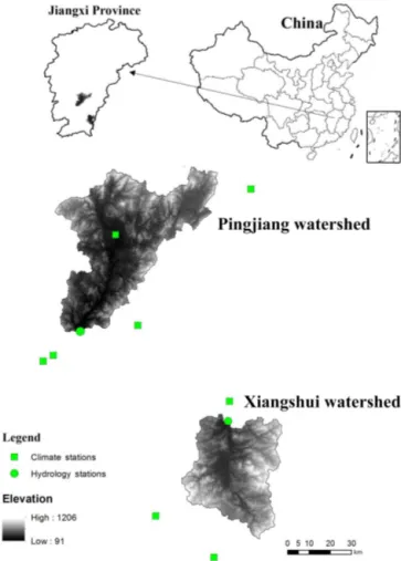
Figure 1.The location of the Pingjiang and Xiangshui watersheds.
2 Watershed descriptions and data 2.1 Watershed characteristics
The Pingjiang and Xiangshui watersheds feed into the Gan River, the largest tributary of the Poyang Lake watershed (Fig. 1). The drainage areas of the two are 2689 and 1758 km2, respectively. The two watersheds are located in the hilly region of Jiangxi Province, China. The Xiangshui watershed is characterized by a steeper topography than the Pingjiang watershed, with the former having higher slopes covering 23.9 % of the watershed area (from 30 to 50◦) while
the latter has only 4.6 % for the same slope class (Table 1). Soils are mountain red soil and yellow-red soil with sandy loam texture in both watersheds. The main characteristics of two watersheds are presented in Table 2.
2
0 50 100 150 200 250 300 350
Jan Feb Mar Apr May Jun Jul Aug Sep Oct Nov Dec
S
tre
am
fl
ow
a
nd
pre
ci
pi
ta
ti
on
(m
m
)
0
10
20
30
40
Te
m
p
e
ra
tu
re
(
oC)
Average monthly streamflow Average monthly precipitation Average maximum temperature Average minimum temperature Month
0 50 100 150 200 250 300
Jan Feb Mar Apr May Jun Jul Aug Sep Oct Nov Dec
S
tre
am
fl
ow
a
nd
pre
ci
pi
ta
ti
on
(m
m
)
0
10
20
30
40
oC
Average monthly streamflow Average monthly precipitation Average maximum temperature Average minimum temperature Month
(a)
(b)
Figure 2.Average monthly streamflow, precipitation, minimum temperature and maximum temperature from 1957 to 2006 for the Pingjiang
watershed(a)and the Xiangshui watershed(b).
Table 1.Averaged slopes in two watersheds studied (Pingjiang and Xiangshui).
Watershed Percentage of watershed area (%)
Slope 25–35◦ 15–25◦ 8–15◦ 3–8◦ <3◦
>35◦
Pingjiang 4.60 52.82 2.40 29.44 6.63 4.11 Xiangshui 23.85 26.99 9.20 33.05 6.17 6.91
19.2◦C, respectively. The maximum temperature in summer
and the minimum temperature in winter are 37 and 0◦C,
re-spectively (Fig. 2).
The majority of annual peak flows correspond to rainfall events in two watersheds. In Pingjiang watershed, annual peak flows are between 137 and 870 m3s−1 per 1000 km2,
while they are between 108 and 728 m3s−1 per 1000 km2
in Xiangshui watershed. Annual minimum flows range from 2.0 to 11.6 m3s−1per 1000 km2in Pingjiang watershed and
are 0.9 to 11.4 m3s−1per 1000 km2in the Xiangshui
water-shed. Average annual mean flows are 848 and 858 m3s−1,
respectively.
The major land cover types include forest, agriculture, grass, and urban and construction land. Subtropical ever-green broad-leaved forest is the major climax vegetation
type in the watersheds studied, includingCastanopsis fabri,
Castanopsis sclerophylla,Schima superba,Sassafras tzumu
andCastanopsis fissa. In contrast, major plantation forests arePinus massoniana,Cunninghamia lanceolata,Camellia oleiferaAbel andPhyllostachys heterocycla.
2.2 Data
Stream flow data area available from 1957 to 2006 for both watersheds. The hydrometric stations for data collection are part of the Chinese National Hydrometric Network (Fig. 1). Climate data are also available for the same length (1957– 2014) for each watershed (five climate stations for Pingjiang and three for Xiangshui), and include the records of daily maximum, mean, and minimum temperatures and daily pre-cipitation. The averaged watershed-based precipitation esti-mates were derived by the Thiessen polygon method.
3 Methods
3.1 Leaf area index (LAI) and forest coverage
Table 2.A summary of watershed characteristics for the Pingjiang and Xiangshui watersheds.
Metrics Pingjiang Xiangshui
Drainage area (km2) 2689.20 1758
Average elevation (m) 298 429
Soil type Mountain red soil and yellow-red soil Mountain red soil and yellow-red soil
Annual mean precipitation (mm) 1575 1611
Annual mean temperature (◦C) 18.9 19.2
Annual mean ET (mm) 879.2 936.8
Annual mean flow (mm) 848 858
Runoff coefficient 0.54 0.53
Maximum flow (m3s−1) 1530 1280
Minimum flow (m3s−1) 5.5 2.3
BioGeoClimatic zone Subtropic monsoon Subtropic monsoon
Forest type Subtropical evergreen broadleaf forest and conifer forest Subtropical evergreen broadleaf forest and conifer forest
Dominant disturbance type Logging Logging
Hydrometric station Hanlinqiao Mazhou
for the period of 1981 to 2014 (http://www.bnu-datacenter. com/). The GLASS LAI data have been validated through the field measurements to ensure data quality for long-term studies in vegetation changes (Liang and Xiao, 2012; Xiao et al., 2014). The growing season LAI values were based on the LAI values from April to October for each year. The watershed-based LAI values were derived by averaging the LAI data for the pixels where more than 50 % of their pixel areas falls inside the watershed boundaries.
Forest change is the main type of land-use change in the watersheds we studied. Because the complete records of an-nual deforestation and reforestation areas are unavailable, forest coverage and LAI data were used to indicate his-toric forest changes during the study period (1957–2006). As shown in Fig. 3, forest cover was greatly reduced in the period 1965–1984 due to large-scale forest disturbance (e.g., deforestation). Since then, forest cover was signif-icantly increased from about 30 % in the 1980s to 70 % in 2006 in both watersheds due to implementation of the reforestation projects (1990–2006) (Fig. 3). Thus, the en-tire study period was divided into the forest disturbance period (1957–1985) and the forest recovery period (1990– 2006).
3.2 Median, high, and low flows
In this study, FDCs (flow-duration curves) were applied to define high, median, and low flows. FDCs represent the per-cent of time streamflow for any given value exceeded or equaled in a period of record (Vogel and Fennessey, 1994). In this study, median flows are defined as the flows that exceed or are equal to Q50 %. High flows are defined as the flows
that exceed or are equal toQ5 %andQ10 %(Q5 %: flows
ex-ceeding 5 % of the time in a given year and Q10 %: flows
exceeding 10 % of the time in a given year), while low flows are defined as the flows that are equal to or less thanQ95 %
(Q95 %: flows exceeding 95 % of the time in a given year)
(Zhang and Wei, 2014b; Liu et al., 2015b).
1940 1950 1960 1970 1980 1990 2000 2010
For
es
t c
ov
era
ge %
20 30 40 50 60 70 80
Year vs. Pingjiang watershed Year vs. Xiangshui watershed
1980 1982 1984 1986 1988 1990 1992 1994 1996 1998 2000 2002 2004 2006 2008
LAI
-2 -1 0 1 2 3 4 5
Year vs. LAI for Pingjiang watershed Year vs. LAI for Xiangshui watershed
y=0.06x+1.03 p<0.01 y=0.05x+2.02 p<0.01
(a)
(b)
In order to assess the impacts of forest changes on high, median, and low flows, the effect of climate variability must be eliminated. For a single watershed, pair-wise comparisons can be used to address this issue (Levy, 1975; Broomell et al., 2011; Zhang and Wei, 2014b; Liu et al., 2015b; Eastwood et al., 2016). Because high flows are mainly caused by rain-fall events, we can find some similar and comparable rainrain-fall events between the reforestation and deforestation periods with similarR5 %andR10 %, respectively (R5 %: rainfall
ex-ceeding 5 % of the time in a given year andR10 %: rainfall
ex-ceeding 10 % of the time in a given year). However, low and median flows are significantly correlated with annual rainfall, annual maximum temperature, and annual mean temperature (Tables 3 and 4). Therefore, paired years between the refor-estation and deforrefor-estation periods were selected for analysis of low and median flows (Tables S1 and S2 in the Supple-ment). More details about this method can be found in Zhang and Wei (2014a) and Liu et al. (2015b).
3.3 Estimation of recession constants
Recession constant is a useful indicator reflecting the char-acteristics of the study basin (Barnes, 1939; Ge et al., 2014). For a watershed, the difference in recession constants of streamflow with similar climate conditions between different periods can be ascribed to the effect of land-cover change, while the difference in recession constants of streamflow be-tween the two watersheds studied, under similar climate con-ditions, can be ascribed to the effect of different water prop-erties on streamflow.
In this paper, the classical recession curve based on a ge-netic algorithm (GA) was adopted to study and analyze the daily runoff (Eqs. 1 and 2).
Qt=Q0e−βt (1)
β=(lnQ0−lnQt) (2)
Here,Q0is the initial discharge (t=0),Qtis the discharge at
a later time (usually in days), andβis the recession constant. The paired-wise approach was also used to assess the ef-fects of forest changes on recession constants. Because high flows are mainly caused by rainfall events (e.g., storm events) in the study area, we can select similar and comparable rain-fall events between the reforestation and the disturbance pe-riods (Table S3 in the Supplement).
4 Results
4.1 High flows’ response to forest changes
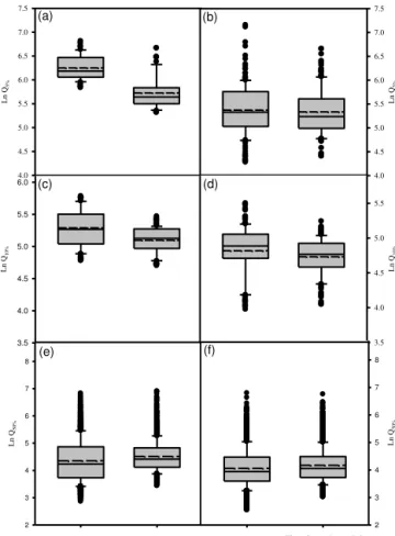
As shown in Fig. 4a, the average magnitude of high flows (Q5 %) in the reforestation period (327.7 m3s−1) was
signif-icantly lower (p <0.01) than that in the deforestation period (534.9 m3s−1) in the Pingjiang watershed. Similarly, the
av-erage magnitude of high flows (Q10 %) in the reforestation
4
The deforestation period The reforestation period The deforestation period The reforestation period
Ln
Q
5%
4.0 4.5 5.0 5.5 6.0 6.5 7.0 7.5
Ln
Q
10%
3.5 4.0 4.5 5.0 5.5 6.0
Ln
Q
5%
4.0 4.5 5.0 5.5 6.0 6.5 7.0 7.5
Ln
Q
10%
3.5 4.0 4.5 5.0 5.5
Ln
Q
50%
2 3 4 5 6 7 8
Ln
Q
50%
2 3 4 5 6 7 8
(a) (b)
(c) (d)
(e) (f)
Figure 4.High flows and median flows for the selected pairs in
the deforestation and reforestation periods:(a)high flows (Q5 %)
for the Pingjiang watershed;(b)high flows (Q5 %) for the
Xiang-shui watershed; (c)high flows (Q10 %) for the Pingjiang
water-shed;(d)high flows (Q10 %) for the Xiangshui watershed;(e)
Me-dian flows (Q50 %) for the Pingjiang watershed; and(f) Median
flows (Q50 %) for the Xiangshui watershed.
period (164.4 m3s−1) was also significantly lower (p <0.01)
than that in the deforestation period (198.7 m3s−1) in the
Pingjiang watershed (Fig. 4c).
For the Xiangshui watershed, the average magnitude of high flows (Q5 %) in the reforestation period (233.0 m3s−1)
was lower than that in the deforestation period (251.4 m3s−1)
(Fig. 4b), but their difference was not statistically sig-nificant (p=0.46). The average magnitude of high flows
(Q10 %) in the reforestation period (118.0 m3s−1) was
signif-icantly lower (p <0.05) than that in the deforestation period (127.9 m3s−1) (Fig. 4d). Thus, reforestation significantly
de-creased high flows in the Pingjiang watershed, while such an effect is relatively limited in the Xiangshui watershed.
4.2 Median flows’ response to forest changes
As shown in Fig. 4e and f, the averaged magnitudes of me-dian flows in the reforestation period (43.1 and 41.5 m3s−1,
T able 3. Correlation analyses between lo w flo ws and climatic v ariables in the Pingjiang and Xiangshui w atersheds. W atersheds Precipitation T max T min T av e W ind speed Manna–K endall Spearman Manna–K endall Spearman Manna–K endall Spearman Manna–K endall Spearman Manna-K endall Spearman Pingjiang 0.48 ∗∗ 0.68 ∗∗ − 0.34 ∗∗ − 0.48 ∗∗ 0.14 0.18 − 0.21 ∗ − 0.32 ∗ − 0.12 − 0.21 Xiangshui 0.57 ∗∗ 0.39 ∗∗ − 0.44 ∗∗ − 0.61 ∗∗ 0.04 0.04 − 0.23 ∗ − 0.05 − 0.07 − 0.11 T av e, T max and T min refer to annual mean, maximum, and minimum temperatures, respecti v ely . ∗ Statistical dif ference at p < 0.05. ∗∗ Statistical dif ference at p < 0.01.
Table 4.Canonical correlation analyses between hydrological vari-ables (median and low flows) and climatic varivari-ables in the Pingjiang and Xiangshui watersheds.
Watersheds Canonical correlation CanonicalR Significant analysis
Pingjiang Precipitation, 0.88 p <0.01 Xiangshui TaveandTmax 0.89 p <0.01
and 0.27, respectively) to those in the deforestation period in Pingjiang and Xiangshui watersheds (40.3 and 38.4 m3s−1,
respectively), indicating that reforestation had no significant effects on median flows (Q50 %) in both watersheds.
4.3 Low flows’ response to forest changes
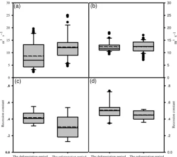
As shown in Fig. 5a, the average magnitude of low flows in the reforestation period (12.3 m3s−1) was significantly
higher (p <0.01) than that in the deforestation period (8.7 m3s−1) in the Pingjiang watershed. In contrast, the
av-erage magnitude of low flows in the deforestation period did not significantly differ from that in the reforestation period (Fig. 5b) in the Xiangshui watershed. Thus, reforestation sig-nificantly increased low flows in the Pingxiang watershed but not in the Xiangshui watershed.
4.4 Responses of recession constants to forest changes As shown in Fig. 5c and d, the averaged recession constant of streamflow in the reforestation period was significantly lower (p=0.049) than that in the deforestation period in the
Pingjiang watershed, while the difference was not significant (p=0.52) in the Xiangshui watershed, suggesting that
hy-drological responses to reforestation is more sensitive in the Pingjiang watershed than in the Xiangshui watershed.
5 Discussion
5
Re
ce
ssi
o
n
c
o
n
st
an
t
0.0 .2 .4 .6 .8
Re
ce
ssi
o
n
c
o
n
st
an
t
0.0 .2 .4 .6 .8
m
s
3
0 5 10 15 20 25 30
m
s
3
0 5 10 15 20 25 30
The deforestation period The reforestation period The deforestation period The reforestation period
(a) (b)
(c) (d)
– 1 – 1
Figure 5.Low flows and recession constants of streamflow for the
selected pairs in the deforestation and reforestation periods:(a)low
flows for the Pingjiang watershed;(b)low flows for the Xiangshui
watershed;(c)recession constants for the Pingjiang watershed; and
(d)recession constants for the Xiangshui watershed.
which consequently enhances soil infiltration capacity and reduces high flows.
Our study showed that reforestation significantly increased low flows in the Pingjiang watershed. Although not statisti-cally significant (p=0.084), the low flows after reforestation
in the Xiangshui watershed were also improved (Fig. 5b). Thus, reforestation had a positive role in low flows in the study watersheds. Our results are consistent with various re-forestation studies, particularly in higher humidity environ-ments (Buttle, 2011; Yao et al., 2012; Liu et al., 2015b). For example, Zhou et al. (2010) studied the effects of large-scale reforestation on hydrology in the whole Guangdong province, and found that an increase of 30 % forest cover played a positive role in redistributing water from the wet season to the dry season and, consequently, in increasing wa-ter yield in the dry season. The main reason for enhancing low flows from reforestation is that reforestation improves vegetation and soil conditions, and consequently improves soil infiltration and groundwater recharging, which have pos-itive effects on low flows.
The responses of low flows to reforestation are inconsis-tent across different climate regimes. Lu et al. (2016) first es-timated the effects of reforestation on groundwater resources using seven evapotranspiration models and suggested that China’s unprecedented reforestation program would result in greatly decreased depth of groundwater in the arid and semi-arid areas of northern China. A similar study conducted in the Loess Plateau of China also found a statistically signifi-cant (p <0.1) reduction of 0.03 mm of groundwater per year from 1955 to 2010 due to implementation of large-scale
re-forestation projects (Gao et al., 2015). The results from a paired watershed experiment in South Africa showed that low flows were reduced by half due to reforestation (Smith and Scott, 1992). A study analyzing the responses of stream-flow to forest plantation expansion in six large river water-sheds (from 94 to 1545 km2) of central-southern Chile in-dicated that reforestation had less effect on low water flows (Q80 % toQ90 %) in relatively drier soils (Iroumé and
Pala-cios, 2013). However, in humid regions, increases in vegeta-tion cover often lead to greater infiltravegeta-tion of rainfall into the soil, and as a result, increase water storages and low flows (Zhou et al., 2010). More case studies are needed before a general comparison between reforestation and low flows can be developed.
Although reforestation generally played a positive role in streamflow in our study area, there are large differences in the hydrological responses between the two study watersheds. As shown above, there are more significant effects on both high and low flows in the Pingjiang watershed than in the Xi-angshui watershed. Since both watersheds have experienced similar historic forest change and climate, we believe that the difference in the responses of high and low flows were mainly due to the difference in their watershed properties. A close examination of their watershed properties shows that the main differences in their properties are to do with water-shed slopes and sizes. Many studies show that waterwater-shed size can be an important factor affecting hydrological responses to land-cover changes (Buttle and Metcalfe, 2000; Blöschl et al., 2007; Zhang and Wei, 2014a; Zhou et al., 2015). A smaller-sized watershed often has less buffering capacity as it may contain fewer heterogeneous landscape components (e.g., wetlands, lakes) and complexities, and as a result, is more sensitive to land-cover changes. In our study, Xiang-shui watershed is much smaller than Pingjiang watershed, so a quicker hydrological response should be expected in Xi-angshui watershed. The limited and slower hydrological re-sponse in Xiangshui watershed after reforestation as com-pared with Pingjiang watershed suggests that a factor other than watershed size came into play. Thus, we reasonably judge that the difference in watershed slope between two watersheds is the major factor determining the variations of their hydrological responses. The Xiangshui watershed has a much larger area percentage (23.9 %) with the slope class (30–50 %) as compared to that (4.6 %) in the Pingjiang wa-tershed (Table 1). In southern China where a monsoon cli-mate is dominant, a steeper watershed often has more se-vere soil erosion if deforestation occurs, and consequently it would take a much longer time to recover through the re-forestation process once severe soil erosion occurred (Chen et al., 2002; Zheng et al., 2015).
cover types, and thus more interactions and complexities be-tween various watershed properties. Several studies on for-est changes and hydrology in large forfor-ested watersheds in British Columbia, Canada, conclude that the effects of for-est changes on water are likely watershed-specific (Lin and Wei, 2008; Zhang and Wei, 2014b), which clearly demon-strates the importance of watershed properties in determining the relationship between forest changes and water. However, assessing how watershed properties affect hydrological re-sponses among other key drivers, such as forest change and climate, is a challenging subject. Some studies have applied integrative indicators such as topographic indices (Woods et al., 1997; Hjerdt et al., 2004; Liu et al., 2012) or flow paths and transit time (McGuire and McDonnell, 2006; Soulsby et al., 2009) to assess watershed behaviors or functions, while other studies used a landscape approach (Poff et al., 2006a, b; Price et al., 2011). Nevertheless, more case studies are needed in this direction.
Our results from this study have important management implications. The Pingjiang and Xiangshui watersheds are very important headwater systems to Poyang Lake, the largest freshwater lake in China, which is crucial to sustain-ing aquatic ecological functions (Guo et al., 2008). Many studies had demonstrated alteration of flow regimes (espe-cially for low and high flows) may be one of the most seri-ous and ongoing threats to the integrity of river ecosystems (Ward et al., 1999; Bunn and Arthington, 2002; Poff and Zimmerman, 2010; Liu et al., 2015b). Therefore, it is highly important to manage flow regimes for sustainable watershed ecosystems in Poyang Lake Basin.
Our results demonstrate a positive effect of reforestation on high and low flows in both Pingjiang and Xiangshui wa-tersheds. This confirms that our reforestation programs im-plemented over the last decades provide important benefits to restoration of watershed functions in terms of hydrology. More importantly, our study found that hydrological recov-ery of a steeper watershed likely takes much longer time once it is deforested or damaged, suggesting that we must take ex-tra care when we design management sex-trategies in more sen-sitive watersheds.
6 Conclusion
We found that reforestation decreased high flows, but in-creased low flows in the watersheds we studied, which is beneficial to the maintenance of aquatic functions and water supply. We also found that there are large variations in hydro-logical responses to similar reforestation levels, likely due to the difference in watershed properties (e.g., watershed slope). Thus, we conclude that hydrological recovery through refor-estation is largely dependant on watershed properties when forest change and climate are similar and comparable.
7 Data availability
The climatic and hydrological data used for this paper are not publicly available due to the constraints of governmental policy in China. The data were obtained through a purchasing agreement for this study.
The Supplement related to this article is available online at doi:10.5194/hess-20-4747-2016-supplement.
Acknowledgements. Funding was provided by Jiangxi Education
Department (No. GJJ151141), the National Science Foundation of China (No. 31170665 and No. 31660234), Jiangxi Education Department (KJLD12097 and KJLD14095), Gan-Po 555 Talent Project, and Funding of Jiangxi Province, Scientific Funding by Jiangxi Province (No. 20142BAB214006 and 20161BBH80049).
Edited by: L. Wang
Reviewed by: two anonymous referees
References
Allan, J. D.: Landscapes and riverscapes: the influence of land use on stream ecosystems, Annu. Rev. Ecol. Evol. Syst., 35, 257– 284, 2004.
Anderson, M. G. and Kneale, P. E.: The influence of low-angled topography on hillslope soil-water convergence and stream dis-charge, J. Hydrol., 57, 65–80, 1982.
Bahremand, A., De Smedt, F., Corluy, J., Liu, Y., Poorova, J., Velci-cka, L., and Kunikova, E.: WetSpa model application for assess-ing reforestation impacts on floods in Margecany–Hornad water-shed, Slovakia, Water Resour. Manage., 21, 1373-1391, 2007.
Barnes, B. S.: The structure of discharge-recession
curves, Eos T. Am. Geophys. Un., 20, 721–725,
doi:10.1029/TR020i004p00721, 1939.
Blöschl, G., Ardoin-Bardin, S., Bonell, M., Dorninger, M., Goodrich, D., Gutknecht, D., Matamoros, D., Merz, B., Shand, P., and Szolgay, J.: At what scales do climate variability and land cover change impact on flooding and low flows?, Hydrol. Pro-cess., 21, 1241–1247, 2007.
Broomell, S. B., David, V., and Por, H.-H.: Pair-wise comparisons of multiple models, Judgment Decis. Mak., 6, 821–831, 2011. Bunn, S. E. and Arthington, A. H.: Basic principles and
ecologi-cal consequences of altered flow regimes for aquatic biodiversity, Environ. Manage., 30, 492–507, 2002.
Buttle, J.: Streamflow response to headwater reforestation in the Ga-naraska River basin, southern Ontario, Canada, Hydrol. Process., 25, 3030–3041, 2011.
Buttle, J. and Metcalfe, R.: Boreal forest disturbance and stream-flow response, northeastern Ontario, Can. J. Fish. Aquat. Sci., 57, 5–18, 2000.
Clinton, B. D.: Stream water responses to timber harvest: Riparian buffer width effectiveness, Forest Ecol. Manage., 261, 979–988, 2011.
Eastwood, A., Brooker, R., Irvine, R., Artz, R., Norton, L., Bullock, J., Ross, L., Fielding, D., Ramsay, S., and Roberts, J.: Does na-ture conservation enhance ecosystem services delivery?, Ecosyst. Serv., 17, 152–162, 2016.
Ford, C. R., Laseter, S. H., Swank, W. T., and Vose, J. M.: Can forest management be used to sustain water-based ecosystem services in the face of climate change?, Ecol. Appl., 21, 2049–2067, 2011. Gafur, A., Jensen, J. R., Borggaard, O. K., and Petersen, L.: Runoff and losses of soil and nutrients from small watersheds un-der shifting cultivation (Jhum) in the Chittagong Hill Tracts of Bangladesh, J. Hydrol., 274, 30–46, 2003.
Gao, Z., Zhang, L., Cheng, L., Zhang, X., Cowan, T., Cai, W., and Brutsaert, W.: Groundwater storage trends in the Loess Plateau of China estimated from streamflow records, J. Hydrol., 530, 281– 290, 2015.
Ge, Y., Jing, T., Liang, C., Wang, X., and Dong, X.: Study on Cor-relation between Recession Coefficients and Catchment Charac-teristics in Pearl River, J. China Hydrol., 34, 72–77, 2014. Gebrehiwot, S. G., Taye, A., and Bishop, K.: Forest cover and
stream flow in a headwater of the Blue Nile: complementing ob-servational data analysis with community perception, Ambio, 39, 284–294, 2010.
Guo, H., Hu, Q., and Jiang, T.: Annual and seasonal streamflow responses to climate and land-cover changes in the Poyang Lake basin, China, J. Hydrol., 355, 106–122, 2008.
Hjerdt, K., McDonnell, J., Seibert, J., and Rodhe, A.: A new topo-graphic index to quantify downslope controls on local drainage, Water Resour. Res., 40, W05602, doi:10.1029/2004WR003130, 2004.
Huang, L., Shao, Q., and Liu, J.: Forest restoration to achieve both ecological and economic progress, Poyang Lake basin, China, Ecol. Eng., 44, 53–60, 2012.
Iroumé, A. and Palacios, H.: Afforestation and changes in for-est composition affect runoff in large river basins with pluvial regime and Mediterranean climate, Chile, J. Hydrol., 505, 113– 125, 2013.
Jackson, R. B., Jobbágy, E. G., Avissar, R., Roy, S. B., Barrett, D. J., Cook, C. W., Farley, K. A., Le Maitre, D. C., McCarl, B. A., and Murray, B. C.: Trading water for carbon with biological carbon sequestration, Science, 310, 1944–1947, 2005.
Levy, K. J.: Large-sample pair-wise comparisons involving corre-lations, proportions, or variances, Psychol. Bull., 82, 177–179, 1975.
Liang, S. and Xiao, Z.: Global land surface products: Leaf area in-dex product data collection (1985–2010), Beijing Normal Uni-versity, Beijing, 2012.
Lin, Y. and Wei, X.: The impact of large-scale forest harvesting on hydrology in the Willow watershed of Central British Columbia, J. Hydrol., 359, 141–149, 2008.
Liu, J., Chen, X., Wu, J., Zhang, X., Feng, D., and Xu, C.-Y.: Grid parameterization of a conceptual distributed hydrological model through integration of a sub-grid topographic index: necessity and practicability, Hydrolog. Sci. J., 57, 282–297, 2012. Liu, W., Wei, X., Liu, S., Liu, Y., Fan, H., Zhang, M., Yin, J., and
Zhan, M.: How do climate and forest changes affect long-erm
streamflow dynamics? A case study in the upper reach of Poyang River basin, Ecohydrology, 8, 46–57, 2015a.
Liu, W., Wei, X., Fan, H., Guo, X., Liu, Y., Zhang, M., and Li, Q.: Response of flow regimes to deforestation and reforestation in a rain-dominated large watershed of subtropical China, Hydrol. Process., 29, 5003–5015, 2015b.
Llorens, P., Poch, R., Latron, J., and Gallart, F.: Rainfall interception by a Pinus sylvestris forest patch overgrown in a Mediterranean mountainous abandoned area I. Monitoring design and results down to the event scale, J. Hydrol., 199, 331–345, 1997. Lu, C., Zhao, T., Shi, X., and Cao, S.: Ecological
restora-tion by afforestarestora-tion may increase groundwater depth and create potentially large ecological and water opportunity costs in arid and semiarid China, J. Clean. Product., doi:10.1016/j.jclepro2016.03.046, online first, 2016.
McGuire, K. J. and McDonnell, J. J.: A review and evaluation of catchment transit time modeling, J. Hydrol., 330, 543–563, 2006. Nadal-Romero, E., Cammeraat, E., Serrano-Muela, M. P., Lana-Renault, N., and Regüés, D.: Hydrological response of an af-forested catchment in a Mediterranean humid mountain area: a comparative study with a natural forest, Hydrol. Process., 30, 2717–2733, doi:10.1002/hyp.10820, 2016.
Poff, N. L. and Zimmerman, J. K.: Ecological responses to altered flow regimes: a literature review to inform the science and man-agement of environmental flows, Freshwater Biol., 55, 194–205, 2010.
Poff, N. L., Olden, J. D., Pepin, D. M., and Bledsoe, B. P.: Plac-ing global stream flow variability in geographic and geomorphic contexts, River Res. Appl., 22, 149–166, 2006a.
Poff, N. L., Bledsoe, B. P., and Cuhaciyan, C. O.: Hydrologic vari-ation with land use across the contiguous United States: geomor-phic and ecological consequences for stream ecosystems, Geo-morphology, 79, 264–285, 2006b.
Price, K., Jackson, C. R., Parker, A. J., Reitan, T., Dowd, J., and Cyterski, M.: Effects of watershed land use and geo-morphology on stream low flows during severe drought con-ditions in the southern Blue Ridge Mountains, Georgia and North Carolina, United States, Water Resour. Res., 47, W02516, doi:10.1029/2010WR009340, 2011.
Schmalz, B., Kuemmerlen, M., Kiesel, J., Cai, Q., Jähnig, S., and Fohrer, N.: Impacts of land use changes on hydrological com-ponents and macroinvertebrate distributions in the Poyang lake area, Ecohydrology, 8, 1119–1136, 2014.
Smith, R. and Scott, D.: The effects of afforestation on low flows in various regions of South Africa, Water SA, 18, 185–194, 1992. Soulsby, C., Tetzlaff, D., and Hrachowitz, M.: Tracers and transit
times: windows for viewing catchment scale storage?, Hydrol. Process., 23, 3503–3507, 2009.
Tran, P., Marincioni, F., and Shaw, R.: Catastrophic flood and forest cover change in the Huong river basin, central Viet Nam: A gap between common perceptions and facts, J. Environ. Manage., 91, 2186–2200, 2010.
Vogel, R. M. and Fennessey, N. M.: Flow-duration curves. I: New interpretation and confidence intervals, J. Water Resour. Pl. Man-age., 120, 485–504, 1994.
Ward, J., Tockner, K., and Schiemer, F.: Biodiversity of floodplain river ecosystems: ecotones and connectivity, Regul. Rivers Res. Manage., 15, 125–139, 1999.
Wei, X., Sun, G., Liu, S., Jiang, H., Zhou, G., and Dai, L.: The Forest–Streamflow Relationship in China: A 40-Year Retro-spect1, J. Am. Water Resour. Assoc., 44, 1076–1085, 2008. Woods, R. A., Sivapalan, M., and Robinson, J. S.: Modeling the
spatial variability of subsurface runoff using a topographic index, Water Resour. Res., 33, 1061–1073, 1997.
Xiao, Z., Liang, S., Wang, J., Chen, P., Yin, X., Zhang, L., and Song, J.: Use of general regression neural networks for generating the GLASS leaf area index product from time-series MODIS surface reflectance, IEEE T. Geosci. Remote, 52, 209–223, 2014. Yao, Y., Cai, T., Wei, X., Zhang, M., and Ju, C.: Effect of forest
recovery on summer streamflow in small forested watersheds, Northeastern China, Hydrol. Process., 26, 1208–1214, 2012.
Zhang, M. and Wei, X.: Contrasted hydrological responses to forest harvesting in two large neighbouring watersheds in snow hydrol-ogy dominant environment: implications for forest management and future forest hydrology studies, Hydrol. Process., 28, 6183– 6195, 2014a.
Zhang, M. and Wei, X.: Alteration of flow regimes caused by large-scale forest disturbance: a case study from a large watershed in the interior of British Columbia, Canada, Ecohydrology, 7, 544– 556, 2014b.
Zheng, L., Zhou, Y., Zhou, X., Li, D., Wu, Z., and Zhou, C.: Re-covery Dynamics after Cutting of Forest Ecosystem Services in Mountain, Issues Forest. Econ., 35, 1–6, 2015.
Zhou, G., Wei, X., Luo, Y., Zhang, M., Li, Y., Qiao, Y., Liu, H., and Wang, C.: Forest recovery and river discharge at the regional scale of Guangdong Province, China, Water Resour. Res., 46, W09503, doi:10.1029/2009WR008829, 2010.