Lakes, reservoirs and ponds, vol. 3(2): 104-113, 2009
©Romanian Limnogeographical Association
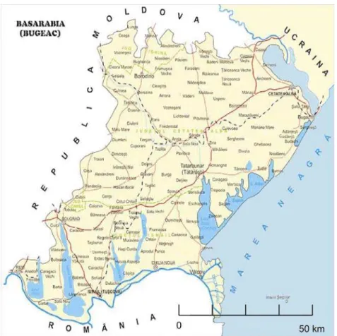
THE LIMANS SOUTH OF BESSARABIA– UKRAINE
CONCERNING IALPUG LAKE
Alexandru PASCU
Department Danube river and water resources, Izmail, Ukraine, pam81@mail.ru
Abstract
In the area of the Lower Danube, north of the branch of Chilia, up to Dniester Liman, are situated over 25 natural lakes, most of them covering small areas. However, some of them cover a more significant area, such as: Cahul, Cartal, Ialpug-Cugurlui, Catlabug, Sofian, Chitai, Sasyk, Shagani, Alibei, Dniester Liman etc. Most of these lakes are related to the Danube (Chilia branch) or to the Black Sea through backwaters and canals with different depths, widths and lengths. At present, these lakes’ water level is closely related to the Danube or the Black Sea level variation.
Keywords: Ialpug, liman, Bassarabia
1. Introduction. The lakes’ classification according to their genesis
The lake is a natural organism formed through the association of two elements: the basin and the water volume. The lakes’ typization needs to be achieved taking into account the main aspects of these two components and also the particular features of the biocenosis, which, together with the first two, which make up the biotope, constitute the lake’s ecosystem.
modifications occurred, starting from the initial aspect (Gastescu, 1963).
The lakes’ classifications take into account different criteria: basin’s origin, waters’ regime, technical regime, mineralization degree, trophic capacity, etc. In general, the choice of the principle laying at the basis of the lakes’ typization is dictated by the purpose of the problem requiring a solution. In the case of the eco-hydrological research, for an adequate and valid typization, it is necessary to find the key elements of the lakes’ hydro regime.
The basic criterion in the lakes’ taxonomy is the origin of the basin, the analysis of the way how the basin appeared allowing the clarification of other aspects such as: water’s regime, hydrophysical, hydrochemical and hydrobiological features. According to this criterion, the waters between Prut and Dniester can be: natural and anthropic.
The natural lakes in the area under analysis can be grouped in several types, according to the morphogenetic processes (fig. 1).
1.1. The lakes resulted from the action of the erosion and alluvial storage can be grouped in:
a) Periodical waterbed lakes. They appear during the hot season, when the small rivers dry off. They appear on the rivers fed by precipitations during the dry summer months, under the form of ponds that occupy the micro-basins situated in the area of the riverbed. They can hardly be included in the category of the lakes, because of their instability and accidental character, and because of the small volume of their internal matter exchanges, compared to the external one. The rivers with a semi - permanent character where such lakes can be found are: Cogalnic, Ialpug and others from the southern area of the Plain of Burnas.
b) Lakes situated in abandoned meanders. They result from the rivers’ action of erosion and lateral alluvial storage, dictated by the decrease of the value of the slope of their longitudinal profile. This kind of lakes can be recognized from the morphological aspect of their storage basin. Generally, their shape is elongated, they have a small width, and their depth is bigger or smaller, depending on their age and on the intensity of their clogging processes. A typical example of such a lake is the Old Dniester (Nistrul Vechi) – the abandoned course of the Dniester, on the right bank of this river in the lower sector.
c) Waterside lakes. They can be found in the lower courses of the rivers: Dniester, Prut and Danube. It is the geomorphological processes of alluvial deposits transport and storage that lead to these lakes’ appearance. During the high waters in the spring and the high floods in the summer, these processes’ action intensifies and, consequently, the quantity of the matters in suspension increases. The decrease of the waters that invade the waterside leads to the storage of the material in suspension. Consequently, the sectors of internal waterside become larger and there appear basins occupied by the overflowing waters. These lakes are linked to the river they belong to by means of natural backwaters. A part of their water comes from the tributaries of the main river or from the underground waters, as well as from atmospheric precipitations. Their morphology and their morphometric features result from the way how they were formed. Usually, they have small depths (1-2 m) and relatively large surfaces (of the order of square kilometers).
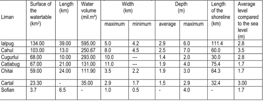
this category belong to the rivers mentioned below (tab.1).
Table 1. Morphometric features of the limans that can be found south of Bessarabia (South of Ukraine)
Width (km) Depth (m) Liman Surface of the watertable (km2)
Length (km)
Water volume (mil.m³)
maximum minimum average maximum Length of the shoreline (km) Average level compared to the sea level (m)
Ialpug 134.00 39.00 595.00 5.0 4.2 2.9 6.0 111.4 2.8
Cahul 103.00 13.0 250.67 8.0 4.5 2.5 7.0 60.0 3.5
Cugurlui 68.00 10.00 293.00 10.0 --- 1.4 2.0 30.0 2.8
Catlabug 67.00 21.00 131.00 11.0 --- 1.9 4.0 75.4 1.7
Chitai 59.00 24.00 111.90 3.5 2.2 1.9 3.0 64.3 1.7
Cartal 23.30 - 35.00 2.9 1.7 1.5 2.9 32.4 3.00
Sofian 3.7 6.5 - 1.0 0.5 - 4.0 - 1.7
1.2. Lakes resulted from the action of the processes of marine abrasion and storage:
a) Maritime lagoons. They are lakes that accompany the Black Sea coast, occupying the basins situated on the land. They are former shallow gulfs, separated from the sea, totally or in part, by sand offshore bars. The maritime lagoons of the area under analysis are concentrated in the coastal area between Lake Sasyk and Dniester Liman, forming the lake group called Tuzla, made up of the lagoons:
Şagani, Alibei, Burnas and Şabolat (Budaki). These lagoons’ depth is small, while their area, in comparison with their depth, is quite large.
b) Limans. They are the result of the cumulated action of the processes of river erosion and marine abrasion and storage. In the coastal area between the mouths of the Danube and the Dniester, the main limans are: Lake Sasyk and Dniester Liman. Their formation was determined by epyrogenetic and eustatic movements. Following the increase in the Black Sea level during the present transgression, the mouths of the Black Sea tributaries have been invaded by the sea waters and turned into gulfs. The processes of marine abrasion turned the slopes of the river valleys into true sea-walls, and the storage processes isolated these gulfs with material transported by the sea currents. The sand offshore bars, which closed the actual limans, have different widths, sometimes being separated by gates, which allow the connection between the limans and the Black Sea (Tab. 2).
2. The history of the lakes’ knowledge and research
the Bessarabian waters began to build up since times out of mind in parallel with the knowledge on the other elements of the natural environment.
The actual scientific research of the territorial waters, in general, and especially of the lakes, begian only at the end of the 19th century and the beginning of the 20th century. Until then, a valuable work on this topic is considered "Descrierea Moldovei"/ The Description of Moldavia (1716) written by the remarkable scholar and Moldavian prince Dimitrie Cantemir.
After Dimitrie Cantemir’s work, we can identify four periods of research concerning the lakes: until the union between Bessarabia and Romania -1917; 1918 – 1944; after the Second World War until 1991; after 1991 until nowadays.
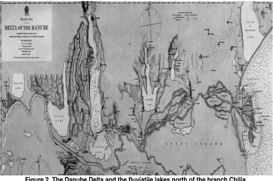
Figure 2. The Danube Delta and the fluviatile lakes north of the branch Chilia (according to T. Sprat, year 1856-1857)
3. The Danubian fluviatile limans
rivers’ valleys by means of offshore bars and sand banks, and upstream, the waters of the respective rivers were stored up. So, the five great lakes are considered typical fluviatile limans.
All the lakes are developed from north to south, reaching the Danube’s major riverbed. During the high floods, the waters of the Danube penetrate in the limans through backwaters and canals, and during the low-water time, the waters move in the other direction. On the backwaters and canals were built hydrotechnical constructions in order to regulate the water exchange. The rivers that pour their waters in the Danubian limans (Cahul, Ialpug, Katlabuh Enica,etc.) have low flows, and during the summer they dry out, and for this reason their flow influences but little the regime’s levels. The surface summed up by the fluviatile limans can reach up to over 550 km2, and the total volume can add up to 1305.27 mil. m3. The lakes are not deep, having, in average, a depth of 0.75-2.2 m, the maximum depths varying between 5-6.4 m (tab.1).
All the limans have high and abrupt eastern and western slopes, made up of clays. The northern shores are low, and the coast line coincides with the bottom of the tributary. At the same time, the southern coasts are low and, except for the coast of Ialpug, they are made up of the Danube’s alluvial deposits. The southern coast of Ialpug is a sand offshore bar, which separates the lake from the waterside of Kugurlui. During the periods with a minimum water level, between the shore line and the abrupt banks there appears an elongated reed plot. The waterside lakes are invaded by hydrophile vegetation. The vegetation covers up to 23% of the surface for Lake Ialpug, 15% for Lake Kitai, 66% of the Lake Cahul, 75% of the surface of Lake Sofian and even 80% in the case of Lake Kugurlui.
3.1. Lake Ialpug
It is located in the south of Bessarabia, south-west of the Ukraine, in Odessa region, including three counties - Izmail, Reni and Bolgrad. It is the largest lake in the group of the Danubian lakes. Its length is 39 km, its width – 6 km and its surface is 149 km².
In the southern area, the Lake Ialpug is connected to Lake Kugurlui. Lake Ialpug communicates with the Danube River by means of three natural arteries: Repida, Scunda and Tabacelu, with different lengths and widths.
The western and eastern shores are abrupt and only in some sectors, the slopes are gradual. In the upper sector, the liman’s valley gradually passes into the valley of the River Ialpug, and the southern shore is made up of a sand offshore bar, which separates the Ialpug from Lake Kugurlui, an offshore bar cut by a canal uniting these two basins.
The average depth is 2.9m and the maximum depth is bigger than 5.5m.
The lacustrian deposits are made up of fine grey silts (49%), organic silts containing detritus with shells (11%), sands (20%) and sands mixed with clay and gravels (20%). In general, the fine deposits occupy the central deeper area, alternating towards the shore with increasingly rower deposits. The transparency of the water of Ialpug is greater than that of other fluviatile limans of the area, because of the granulometric makeup of the deposits of the shore.
Water balance and level variations in the case of Lake Ialpug
The elements of the hydro balance are as input: the leakage from the drainage basin of lake Ialpug (Y1), water coming from the Danube (Y2), water from springs (U1) and, obviously form the precipitations that fall on the surface of the lake (X). As output: leakage through the backwaters towards the Danube (Y3), evaporation on the surface of the lake (Z), infiltration through the bottom of the basin (U2) and artificial use (W).
Consequently, the general equation for the Lake Ialpug’s hydro balance is: Y1+Y2+U1+X– (Y3+Z+U2+W)=±DV,
where: ±DV – represents the difference of water volume in the lake for the period under analysis.
So, the variation of the water volume in the lakes depends on the volumes of the lake’s input and output, which in turn determine the variation of the lake’s level.
The level variations according to the season are according with the ratio between the water input and output and occur during the same months of the year, because of the stability of the factors that trigger them.
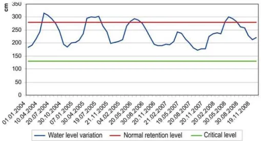
The lake Ialpug’s hydro regime is largely determined by the Danube’s hydro regime. During the Danube’s high water-levels, the lake’s basin is filled up with Danubian water (by means of the canals Repida and Scunda, Tabacelu), and in the case of the minimum level, the connection with the lake is interrupted or strongly reduced, so the lake comes under the influence of the climatic conditions characteristic of the season. The annual level variation records smaller amplitudes than the amplitude of the Danube’s level variations. The increase in level begins at the end of February-the beginning of March, and during the months of April-May is recorded the maximum level, while the minimum level is recorded during the months of December - February (fig. 3).
Figure 3 Level variations of the waters in the Lake Ialpug (during the period 2004-2008)
Hydrochemical characteristics
Under natural conditions, the water of the Lake Ialpug contains a great quantity of dissolved substances: gases, mineral and organic substances. The enrichment of the water with dissolved substances occurs following its contact with the atmosphere and the sediments on the bottom, from the basin leakage, and following the activities of the hydrobiontes and their decomposition. The gases penetrate in the water through molecular diffusion on the contact surface between the air and water environment. The transfer of substances from the rocks into the water also occurs through molecular diffusion and also through the water exchange between the water mass and the bottom deposits, and the production of gases by the bottom deposits. Beside the dissolved substances, the water contains as well material in suspension, made up of mineral and organic particles.
The degree of mineralization of the water in the Lake Ialpug varies from one year to the next and from one season to the next. So, the maximum values for the water mineralization range between 1024.4 mg/l and 2101.4mg/l. The minimum values of the mineralization are recorded, in general, during the months of April-June, and the maximum ones in August-October.
The water of the Lake Ialpug belongs to the category of sulphatated waters. In its chemical makeup, the first position is occupied by the SO4- anion (323,4 – 569.3 mg/l), which is followed by HCO3ֿ (218.4 – 545.3 mg/l) and Clֿ(188.0 – 304 mg/l).
The dominant cations in the water of the Ialpug Lake are: Na+ and K+, their sum ranging between 120.0 and 751.7 mg/l, followed by Mg+, Ca+.
They are indispensable to life and can be found in the water in their organic or mineral form.
Flora and fauna
The aquatic vegetation is specific for the climate conditions of this lake. The factors determining the type of vegetation are first of all the quality of the water and then the bottom deposits.
The vegetation (macrophitae) in the area of the shore is made up of reed, club rush, MANA APEI, bur flag, water lily and others. The reed can be found as islets, occupying as well a narrow area in the upper sector. This vegetation forms thickets covering quite significant areas and producing scores or even hundreds of tons of biomass (reed 9-11 kg/m2, club rush - 6-8 kg/m2).
The hardly accessible reed and club rush thickets constitute favorable spots for wildlife species and especially for aquatic birds.
Bibliography
Antonescu, C.S., (1963) Biologia apelor (Water Biology), Ed. Didactică şi Pedagogică, Bucuresti.
Bratescu, C., (1941), Contribuţii la cunoaşterea văii Nistrului (Contributions to the Knowledge of the Dniester’s Valley), Bul. S.R.R. de geografie, Tome 59, Bucuresti.
Driga, B. (2004), Delta Dunarii. Sistemul circulaţiei apei (The Water’s Circulation System), Casa Cartii de Stiinta, Cluj-Napoca.
Gastescu, P. (1971), Lacurile din România. Limnologie regională (The Lakes of Romania. Regional Limnology), Edit. Academiei Romane, Bucuresti.
Gastescu, P., (1972), Limnologia-ştiinţă de contact între geografie, hidrologie şi biologie (Limnology – A Science at the Boundary between Geography, Hydrology and Biology), Progresele stiinţei, Nr. 3, Academia Romana.
Gastescu, P., (1979, 2002, 2006, 2008), Lacurile Terrei (Terra’s Lakes).
Gastescu, P. Ştiucă, R., (2008), Delta Dunării.Rezervaţie a Biosferei (The Danube Delta. A Biosphere Reserve), Edit.CDPress.