ECOMORPHOLOGICAL ANALYSIS OF FLUVIAL
HABITATS
OF THE
UPSTREAM PART OF RIO DAS VELHAS/MG, BRAZIL
Helena Lúcia Menezes Ferreira Depto de Geologia, Universidade Federal de Ouro Preto, Ouro Preto/MG, CEP 35400-000 Fundação Centro Tecnológico de Minas Gerais, Belo Horizonte/MG, CEP 31170-000 ([email protected]) Paulo de Tarso Amorim Castro Depto de Geologia, Universidade Federal de Ouro Preto, Ouro Preto/MG, CEP 35400-000 ([email protected])
INTRODUCTION
In accord to the principles that lead to the sustainable development the International Council of Scientific Unions (ICSU) says that the science of century XXI must produce integration in front of the environmental challenges in global scale. Among these challenges, it can be distinguish the increasing limitation in the freshwater availability face to the current way of its use
The agent of stress of fluvial ecosystems are have large origin and intensity and play inportant role in the destruction and degradation of habitats. The physical and morphologic
alterations of the rivers, besides affecting the flow regime, reduce the fluvial corridor and degrade the riparian zone with consequent losses in the biodiversity and the ecological integrity of fluvial environments. In some situations the agent of stress can overshadow the researchs of the effect of the toxicity and the pollution of the waters (Karr et al. 1986). In
others, they can evidence that the way adopted in the evaluation and monitoring of the quality of waters, tough valid and viable, are weak and insufficient to promote the sustainable use of the freshwater resources (Miller et al. 1988, Zalewski & Robarts 2003).
The knowledge of the characteristics of the habitat is the best way to understand the
Sociedade & Natureza, Uberlândia, Special Issue, 327-336, May, 2005 328 and contributes to explain the distribution and the biodiversity of rivers, between distinct ecoclimatic regions or ecorregions.
In this perspective, the ecomorfologic evaluation extends the knowledge of the processes that act on the changes in the quality of waters. It incorporates the evaluation of the ecological integrity of the fluvial systems in order to have better understanding on the capacity of
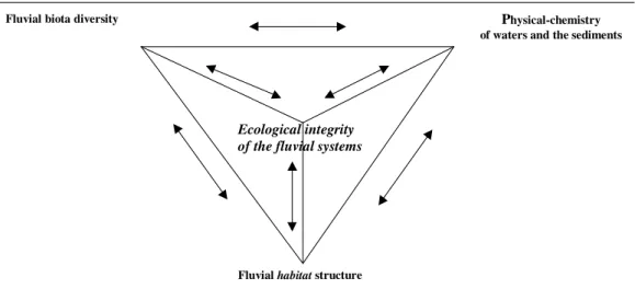
support of these systems to the anthropogenic impacts. The ecomorfologic evaluation integrates in only one entity the fluvial basin, the geomorphology, the sedimentology, biota aquatic and general aspects of the physical-chemistry of waters and the sediments (Figure 1).
Ecological integrity of the fluvial systems
Fluvial biota diversity Physical-chemistry
of waters and the sediments
Fluvial habitat structure
Figure 1 – The end terms and the integration of the fluvial ecomorphology.
The methodological principle of the ecomorphologic evaluation is based on the properties and attributes of the habitat. The habitat interacts to the landscape and to the geomorphologic
and sedimentologic processes and factors in differentiated hierarchic levels of scale from large scale, such as the region and its fluvial basin, to the small one, represented by the diverse ecophysic attributes that characterize habitats in the fluvial segments and stretches
(Figure 2).
Due to the necessity to incorporate more including scales in the programs of evaluation and monitoring water resources, there had been developed two ways to interpret the structure of the habitat. The first one includes the characterization of the morphology and the margin of
The second way consists of a faster, semi-quantitative visual evaluation, that it makes possible to characterize, in situ, the global the physical quality of the habitat in the fluvial
segments. As examples of this second way are the GNWK adopted by the Department of Environment of Nordrhein-Westfalen in Germany (LUA 1998), the Rapid Bioassessment Protocols (RBPs) and River Rapid Survey (RHS) adopted, respectively, by the environmental agencies of U.S.A. and by the Great Britain (Barbour et al. 1999). The Australian River
Assessment System (AusRivAS) adopted in Australia is another example (Parsons et al.
2002).
This study has as scope testing the applicability of the fast ecomorphologic evaluation in order to identify the physical factors that influence the spatial differences of freshwater biota in streams of the upper Rio das Velhas drainage basin. Its development was based on observation and it has as purpose to elucidate and to describe ecomorphologic standards derived from the data. It do not the intention to test previous hypotheses. In the search of the standards it was detailed the global quality of the habitats that act as a refugee for the
Sociedade & Natureza, Uberlândia, Special Issue, 327-336, May, 2005 330 Figure 2 - Hierarchic levels of the ecomorphologic evaluation analysis,
adapted from Kershner & Snider (1994) e MNR (1998).
STUDY AREA
The study was carried out in the upstream region of the Rio das Velhas fluvial basin and it has covered an area about 2251,3 Km2. From the spring of Rio das Velhas stream, in the Antônio Pereira Mountain, located at São Bartolomeu district of Ouro Preto (1160m in high), until its confluence with the Sabará creek, in the district of Roças Grandes, city of Sabará (680m high) the Rio das Velhas has 113km length (Figure 3).
The region is located in the central-south part of the Minas Gerais State in the Atlantic forest and the high grasslands biomas. It presents a peaks and valley relief and its thermal index range between 180C and 200C (isothermal annual). The southern part, in the
W
W
Wa
a
at
t
te
e
er
rs
r
s
sh
h
he
e
ed
d
d
PhysiographyGeology Geomorphology
Soil types
Land use
F
F
Fl
l
lu
u
uv
v
vi
i
ia
a
al
l
l
s
s
se
e
eg
g
gm
m
me
e
en
n
nt
t
ts
s
s
a
a
an
n
nd
d
d
s
s
st
t
tr
r
re
e
et
t
tc
c
ch
h
he
e
es
s
s
Sedimentology and GeomorphologyHidrology Morphology
Bankfull Land use Water uses Riparian vegetation
HHHaababbiiitttaaatttsss Velocity Stream bed Woody debris Sediments
neighborhoods of Ouro Preto, is an isolated nucleus of high rainfall, around 1800-2000mm annual.
This region has faulted rocks that act as good aquifers that feed the main springs of the high course of Rio da Velhas basin. It is located in the southern extremity of the São Francisco Craton, in the Quadrilátero Ferrífero region, on the rocks of the Minas and Rio das Velhas supergroups, mainly, and on the rocks of the Belo Horizonte and Bação complexes.
The Rio das Velhas basin has great importance in terms of environmental, economic and social aspect for the Minas Gerais State. It is the large water supply of Belo Horizonte (State capital), 60% of the water of the city come from its sources. Along its watershed there are areas with intense iron mining activity. The large number of mines, most of them in open pits, assumes special relevance in the management of the high course of the basin. The mining and the urban occupation are for the main causes of the erosion. The suppression of the riparian expose the channel borders to the erosion in the majority of the water courses of the basin. The urban and of the mining effluents added to the inadequate destination of the urban solid residues are the main causes of the pollution of waters (SEPLAN/COBRAPE 1997).
Sociedade & Natureza, Uberlândia, Special Issue, 327-336, May, 2005 332 Figure 3 – The upstream region of the Rio das Velhas fluvial basin.
MATERIAL AND METHODS
The studies had been carried out through dry season, from June the August of 2002. The dry season offers large availability of biotopes due to reduction of the outflow and minor disturbance factors incidence (Junqueira et al. 1998). This is favorable to the increment of the
heterogeneity of biota adhered or associated with substrata in the edges and streambed of the channel (Allan 1996; Cazaubon et al. 1995, Emiliane 1997, Ács & Kiss 1993 apud Mourthé
2000). The registered maximum outflow did not exceed 40m3/s.
The sample net has 20 sites (Figure 3) related to the fluvial segments (about 100m2) and fluvial stretches (about 10m2) that are representative of different ecophysical conditions (for example: sediment grainsize, hydrologic characteristic and aspects of the riparian vegetation),. This sample net may also show antropogenic interference that can produce impacts in fluvial
habitats (Junqueira et al. 1998). Of these sample net, 8 sample sites are located in the main
creeks of Cortesia, da Prata, Sabará and Mingu, for the right edge; Itabirito e do Peixe rivers; creeks of do Silva, dos Macacos, Cristais, Água Suja and Marumbé, for the left edge).
The ecomorphologic evaluation is supported in Barbour et al. (1999). It is consisted of
visual observation and in situ measurements of the geomorphologic and sedimentologic
attributes as follows: type of substrata, burial of substrata, deposition of sediment, flowing condition, alteration of the channel, stability of the channels edges, protection of the channel margins by the vegetation and width of the riparian zone. The studies of the aquatic communities had included the analysis of the richness and abundance of the plancktonic, perifitic and pseudoperifitic microfauna and of the macroinvertebrates, in accordance with methodology described in Junqueira et al. (1998).
The analysis of the data was carried out in accordance with Ludwig & Reynolds (1988) and Valentin (2000). The principal components analyses (PCA) and cluster analyses had been applied (method using averages - UPGMA and euclidean distance). The PCA was used in order to reduce the number of variable to the main factors to which they associate the variables that show degrees of interdependence or correlation. The cluster analysis was used to detect the general standards of association among the sample points, in function of the regulating factors of these associations.
RESULTS
The PCA reduced to 9 the 20 selected variables and discern three axis that explain, in the set, 63.6% of the variability among the stretches and segments. To axis 1 (27,7%) there are associated the physical attributes related to the amount and variety of substrata (for example: pebbles, blocks, trunks and twigs) and to the protection of the channel edges by the riparian vegetation. The axis 2 (21,7%) show the influence of the stability of the channel edges as being the conditioning factor of the variability, while the axis 3 (14,2%) the deposition of sediments, with negative correlation is the explain variable.
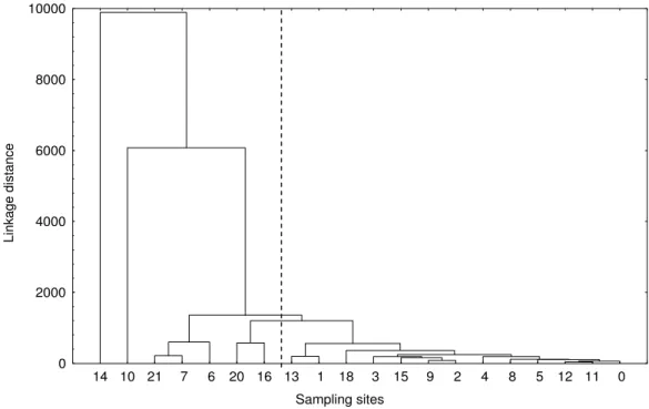
The clusters among the river stretches and segments, Figure 4, also show the influence of the physical characteristics of habitats in the richness and abundance of the fauna
communities, in particular for the points grouped to the right of the hatched line. At the left of hatched line, the organic load of the waters from punctual and diffuse sources of the draining basin preponderate on the physical quality of the habitat.
Sociedade & Natureza, Uberlândia, Special Issue, 327-336, May, 2005 334 vegetation and the small deposition of sediments in the stream bed confer to the fluvial stretches and segments of the Rio das Velhas river. Particularly, those sites next to headwaters (points 0 and 1) and points 11 (Marumbé creek), 5 (Silva creek) and 8 (Peixe river) are relatively less degraded environments, being indicative of conditions favorable to the establishment and development of more diversified biota. Such environments can be used as sites of reference due to the low degree of disturbance, in contraposition to those whose adverse effect of the urbanization and development had taken the loss and degradation of the
habitat.
Sampling sites
L
in
k
a
g
e
d
is
ta
n
c
e
0 2000 4000 6000 8000 10000
14 10 21 7 6 20 16 13 1 18 3 15 9 2 4 8 5 12 11 0
Figure 4 – Cluster of the sampling sites of the upstream Rio das Velhas basin.
CONCLUSION
The exploratory analysis in the upper Rio das Velhas fluvial basin show the potential of application of rapid ecomorphological approach in monitoring and assessment of fluvial basin.
abundance of species). It extends the possibilities of formularization of hypotheses to interpret the relations among causes and effects of the complexity of the analyzed system.
It disponibilizes additional information that associates to the biological physical-chemical conditions of waters that turn possible to evaluate the ecological integrity of the fluvial systems without limiting it to anthropocentric vision of utilitarian standards of use of waters.
This analysis can set bounds for the interactive development and to interdisciplinary relation of scientific research and contributes to speed up the advances in the agreement of the dynamics and functioning of fluvial environments. It also can be na aid for supplying the capacity to incorporate the use and the progress of its knowledge in the evaluation, monitoring, handling and restoration of lotic ecosystems.
BIBLIOGRAPHY
ALLAN, J.D. 1996. Stream ecology: structure and function of running waters. Chapman &
Hall, London. 388p.
BARBOUR, M.T.; GERRISTSEN, J.; SYNDER, B.D.; STRIBLING, J.B. 1999. Habitat
assessment and physicochemical parameters. In: Rapid bioassessment protocols for use in streams and wadeable rivers: periphyton, benthic macroinvertebrates and fish. EPA
841-B-99-002. US. Washington, D.C. chapter 5. 34p. Disponível em: <http://www.epa.gov/owow/monitoring/techmon.html>.
HILDREW, A.G.; GILLER. P.S. 1996. Patchiness, species interactions and disturbance in the stream benthos. In: GILLER, P.S.; HILDREW, A.G.; RAFFAELLI, D.G.; Aquatic ecology: scale, pattern and process. Blackwell Science Ltd. (ed). p.21-62.
JUNQUEIRA, M.V. (Coord.). 1998. Biomonitoramento da qualidade da água na bacia do alto rio das Velhas. Belo Horizonte. Belo Horizonte: CETEC. 110p., anexos. (Relatório).
KARR, J.R.; FAUSCH, K.D.; ANGERMEIER, P.I.; YANT, P.R.; SCHLOWER, I.J. 1986. A assesment of biological integrity in running waters: a method and its rationale. Illinois Nat. Histt. Surv. Spec. Publ. 5.
KERSHNER, J.L.; SNIDER, W.M. 1994. Importance of a habitat-level classification system
to design in stream flow studies. In: BOON, P.J.; CALOW, P.; PETTS, G.E. River
Sociedade & Natureza, Uberlândia, Special Issue, 327-336, May, 2005 336 LUA – LANDESUMWELTAMT. 1998. Merkblätter nr.14. Gewässerstrukturgüte in Nordrhein-Westfalen Kartieranleitung (GNWK). 158p.
LUDWIG, J.A.; REYNOLDS, J.F. 1988. Statistical ecology. A primer on methods and computing. New York, John Wiley & Sons. 329p.
MILLER, D.L.; LEONARD, P.M.; HUGHES, R.M.; KARR, J.R.; MOYLE, P.B.; SCHRADER, L.H.; THOMPSON, B.A.; DANIELS, R.A.; FAUSCH, K.D.; FITZHUGH, G.A.; GAMMON, J.R.; HALLIWELL, D.B.; ANGERMEIERP, L.; ORTH, D.J. 1988. Regional applications of an index of biotic integrity for use in water resource management.
Fisheries, v.13, n.5, p.12-20.
MNR - Ministry of Natural Resource. 1994. Natural channel systems: an approach to management and design. Ontario. 103p.
MOURTHË JÜNIOR, C.A. 2000. Modificações Estruturais na Comunidade de Diatomáceas em um Gradiente de Poluição Hídrica. Trecho superior da bacia do rio das
Velhas (Região Metropolitana de Belo Horizonte/MG). Belo Horizonte/MG. UFMG, 92p.
(Dissertação Mestrado em Ecologia Conservação e Manejo da Vida Silvestre).
PARSONS, M.; THOMS, M.; NORRIS, R. 2002. Australian river assessment system: AusRivAS physical assessment protocol. Monitoring river health initiative technical Report
number 22. Commonwealth of Australia and University Canberra, Canberra. 116p. Disponível em:<http://ausrivas.canberra.edu.au/geoassessment/physchem/man/propotocol/ chapter1b.html>
SEPLAN/COBRAPE 1997. Estudo de implantação da agência de bacia do rio das Velhas. Produto A4 – Livro Branco. Disponível em: <http://www.hidricos.mg.gov.br/in-bacia.htm> VALENTIN, J.L. 2000. Ecologia numérica. Uma introdução à análise multivariada de dados ecológicos. Rio de Janeiro, Editora Interciência. 117p.