Metadata of the chapter that will be visualized online
Chapter Title
Remote Sensing Technologies for the Assessment of Marine and Coastal
Ecosystems
Copyright Year
2016
Copyright Holder
Springer International Publishing Switzerland
Corresponding Author Family Name
Gutierres
Particle
Given Name
Francisco
Suffix
Division
Institute of Geography and Spatial
Planning
Organization/University
University of Lisbon
Street
Edifício IGOT, Avenida Prof. Gama
Pinto
Postcode
1600-214
City
Lisbon
Country
Portugal
[email protected]
Author
Family Name
Teodoro
Particle
Given Name
Ana Cláudia
Suffix
Division
Earth Sciences Institute (ICT)
and Department of Geosciences,
Environment and Land Planning,
Faculty of Sciences
Organization/University
University of Porto
Street
Rua do Campo Alegre
Postcode
4169-007
City
Porto
Country
Portugal
Particle
Given Name
Eusébio
Suffix
Division
Institute of Geography and Spatial
Planning
Organization/University
University of Lisbon
Street
Edifício IGOT, Avenida Prof. Gama
Pinto
Postcode
1600-214
City
Lisbon
Country
Portugal
[email protected]
Author
Family Name
Neto
Particle
Given Name
Carlos
Suffix
Division
Institute of Geography and Spatial
Planning
Organization/University
University of Lisbon
Street
Edifício IGOT, Avenida Prof. Gama
Pinto
Postcode
1600-214
City
Lisbon
Country
Portugal
[email protected]
Author
Family Name
Costa
Particle
Given Name
José Carlos
Suffix
Division
Higher Institute of Agronomy
Organization/University
University of Lisbon
Street
Tapada da Ajuda
City
Lisbon
Country
Portugal
[email protected]
Abstract
This chapter reviews the Remote Sensing (RS) technologies that are particularly
appropriate for marine and coastal ecosystem research and management. RS
techniques are used to perform analysis of water quality in coastal water
bodies; to identify, characterize and analyze river plumes; to extract estuarine/
coastal sandy bodies; to identify beach features/patterns; and to evaluate the
changes and integrity (health) of the coastal lagoon habitats. For effective
management of these ecosystems, it is essential to have satellite data available
and complementary accurate information about the current state of the coastal
regions, in addition to well-informed forecasts about its future state. In recent
years, the use of space, air and ground-based RS strategies has allowed for the
rapid data collection, Image processing (Pixel-Based and Object-Based Image
Analysis (OBIA) classification) and dissemination of such information to
reduce vulnerability to natural hazards, anthropic pressures, and to monitoring
essential ecological processes, life support systems and biological diversity.
AUTHOR QUERIES
Q1 Please check captured abstract if correct.
© Springer International Publishing Switzerland 2016
C.W. Finkl, C. Makowski (eds.), Seafloor Mapping along Continental Shelves, Coastal Research Library 13, DOI 10.1007/978-3-319-25121-9_3
Remote Sensing Technologies
for the Assessment of Marine
and Coastal Ecosystems
Francisco Gutierres, Ana Cláudia Teodoro,
Eusébio Reis, Carlos Neto, and José Carlos Costa
Abstract
This chapter reviews the Remote Sensing (RS) technologies that are par-ticularly appropriate for marine and coastal ecosystem research and man-agement. RS techniques are used to perform analysis of water quality in coastal water bodies; to identify, characterize and analyze river plumes; to extract estuarine/coastal sandy bodies; to identify beach features/patterns; and to evaluate the changes and integrity (health) of the coastal lagoon habitats. For effective management of these ecosystems, it is essential to have satellite data available and complementary accurate information about the current state of the coastal regions, in addition to well-informed forecasts about its future state. In recent years, the use of space, air and ground-based RS strategies has allowed for the rapid data collection, Image processing (Pixel-Based and Object-Based Image Analysis (OBIA) classification) and dissemination of such information to reduce vulnerability to natural hazards, anthropic pressures, and to monitoring essential ecological processes, life support systems and biological diversity.
[AU1]
F. Gutierres (*) • E. Reis • C. Neto
Institute of Geography and Spatial Planning, University of Lisbon, Edifício IGOT, Avenida Prof. Gama Pinto, 1600-214 Lisbon, Portugal
e-mail: [email protected];
[email protected]; [email protected]
A.C. Teodoro
Earth Sciences Institute (ICT) and Department of Geosciences, Environment and Land Planning, Faculty of Sciences, University of Porto, Rua do Campo Alegre, 4169-007 Porto, Portugal e-mail: [email protected]
J.C. Costa
Higher Institute of Agronomy, University of Lisbon, Tapada da Ajuda, 1349-017 Lisbon, Portugal e-mail: [email protected]
3
1 2 3 4 5 6 7 8 9 10 11 12 13 14 15 16 17 18 19 20 21 223.1
Introduction
The coastal areas are zones of primary impor-tance from human and ecological perspectives. Nearly all of the maritime resource is on a narrow continental shelf which is affected by ecological pressures owing to a large-scale population increase in the coastal areas (half of the world’s population lives at least 60 km from a coast, and the proportion will be 70 % in 2020) (FAO 2014).
In recent years, a number of RS are available to resource managers for developing effective marine ecosystem management initiatives, including the use of information technology for analyzing and understanding an ecosystem as a whole and not simply the targeted resource or a specific area.
The wide applicability of RS techniques has allowed researchers and managers to take a broader view of coastal ecosystem assessment and management (Klemas 2011; Yang 2009). Ecological patterns, processes and changes in composition and structure of coastal ecosystems can be quantified using satellite imagery. When these RS tools for generating, organizing, stor-ing, and analyzing spatial information are com-bined with mathematical and data mining models, marine resource planners and managers have the means for accessing the impacts of natural events, anthropic and alternative management practices on pattern and process on coastal areas.
RS provide not only photographic representa-tion of the coastal and marine surfaces, but also physical (absorbency, reflectance and emissivity) measurements of various properties of these eco-systems. These spectral characteristics can be used to access the major factors affecting water quality in coastal water bodies (e.g. Total Suspended Matter (TSM) and dissolved organic matter (DOM)) (Vanhellemont and Ruddick
2014; Tang et al. 2013; Zhu et al. 2013, 2014; Liew et al. 2011; Vantrepotte et al. 2011; Nechad et al. 2010; Rodríguez-Guzmán and Gilbes- Santaella 2009; Wang 2009; Teodoro et al. 2007a,
b; Zhou et al. 2006; Bustamante et al. 2006; Ruddick et al. 2003); to identify, characterize and analyze river plumes (Mendes et al. 2014; Guneroglu et al. 2013; Gonçalves et al. 2012;
Rudorff et al. 2011; Teodoro et al. 2009a; Otero et al. 2008); to extract estuarine/coastal sandy bodies (Teodoro and Gonçalves 2012; Chowdhury et al. 2011; Teodoro et al. 2011a, b; Silveira and Heleno 2009; Baptista et al. 2008); to identify beach features/patterns (Teodoro 2015; Teodoro et al. 2009b, 2010, 2011b, c, 2013; Mujabar and Chandrasekar 2012; Harris et al. 2011; Pais- Barbosa et al. 2009); and to evaluate the changes and integrity (health) of the coastal lagoon habi-tats (Gutierres 2014; McCarthy and Halls 2014; Bustamante et al. 2013; Vahtmäe and Kutser
2013; Urbański 2009; Kutser et al. 2006; Druon et al. 2004; Sousa et al. 2003, 2010, 2013; Kandus et al. 1999), at various scales. In fact, the RS cre-ates new opportunities for identifying which parameters function as regulators of marine/cos-tal ecosystems activity at local and regional lev-els and how these variables differ across spatial and temporal scales.
Within the above context, this chapter is dedi-cated to the development of RS for monitoring, synthesis and modeling in the Portuguese coastal environment. Specifically, this chapter concen-trates on the following aspects:
• Reviews the types of satellite imagery and RS methods applied in the marine/coastal envi-ronment management; and
• Examines some latest development in the use of RS for marine/coastal ecosystem assess-ment with emphasis on estuaries and coastal zones, shorelines and coastal wetlands. In addition to scientific research, the chapter has incorporated a management component that can be found in six case studies, discussing our understanding of the status, trends and threats in coastal ecosystems. The sections below describe in more detail the conceptual and technical issues of applying RS techniques in coastal environ-ments; and the major findings of different research projects related to the development of RS techniques to identify ocean physical, optical, biological changes and coastal wetlands, using spectral and temporal signatures, supervised and unsupervised classification algorithms (pixel- based or object-based) and data mining models.
[AU2] F. Gutierres et al. 23 24 25 26 27 28 29 30 31 32 33 34 35 36 37 38 39 40 41 42 43 44 45 46 47 48 49 50 51 52 53 54 55 56 57 58 59 60 61 62 63 64 65 66 67 68 69 70 71 72 73 74 75 76 77 78 79 80 81 82 83 84 85 86 87 88 89 90 91 92 93 94 95 96 97 98 99 100 101 102 103 104 105 106 107 108 109 110 111 112 113 114 115
3.2
Status and Improvements
for Assessment of Marine
and Coastal Ecosystems
3.2.1 Remotely Sensed Data
Today, and given the numerous RS satellite imag-ing systems available, it is a challenge to choose the most appropriate satellite images for observ-ing marine/coastal ecosystems – for technical details of the classification of remote sensors, readers can refer to see Klemas (2011). The digi-tal systems can be grouped into four different types of resolution: spatial, spectral, radiometric, and temporal. The RS requirements for Open Ocean, Estuaries/Coastal lagoons and Land are presented in Table 3.1 (Klemas 2011). A list of the more relevant satellite sensors to the assess-ment of marine ecosystems is shown in Table 3.2, where several multispectral images can be used for mapping concentrations of organic/inorganic suspended particles, dissolved substances in coastal waters; coastal features and patterns and for others applications (Teodoro and Gonçalves
2011).
We highlighted some RS data that can be used in studies of marine/coastal ecosystems. Depending on the research to carry out it is important to consider the temporal or spatial characteristics of the RS satellite imagery used in each analysis. In the work developed by Teodoro et al. (2009a) and Teodoro and Gonçalves (2011), it was used the TSM concentration retrieved from MERIS scene, which allowed the extraction of objects corresponding to river plumes. The medium spatial resolution of MERIS data is enough to estimate the river plume size. MODIS has been providing atmospherically operational products since 2000 (Terra) and 2002 (Aqua) with different temporal frequencies. Moreover, the high temporal of MERIS data seems to be essential in monitoring river plume, subject to rapid changes due to extreme situations (e.g. pre-cipitation, floods). According the same authors, the high spatial resolution of IKONOS-2 data seems to be a crucial factor in the sand spit area estimation.
Bustamante et al. (2013) based on MODIS provides the most coherent data record at moder-ate spatial resolution to study wetland dynamics included in the Spanish Ramsar Site Doñana, while LANDSAT family sensors (Multispectral Scanner – MSS, Thematic Mapper – TM, Enhanced Thematic Mapper Plus – ETM+ and Operational Land Imager – OLI) have the longest temporal coverage (>30 years) with a higher spa-tial resolution (30–90 m) but lower temporal fre-quency (16 days) (see Roy et al. 2014).
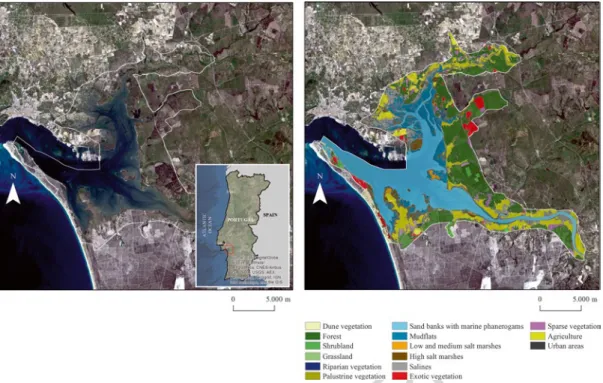
Gutierres (2014) showed that LANDSAT sen-sor has been an effective source for land cover data (see Fig. 3.1). Its 30 m resolution and spec-tral bands have proved adequate for observing land cover changes in coastal lagoons on the Portuguese southwest coast. Figure 3.2 shows a land cover map of the Site of Community Importance (SCI) of the Sado Estuary derived from a LANDSAT-7 ETM+ image containing 13 vegetation units (two wetland and three water classes), and also agricultural and urban classes.
Other similar satellites with medium- resolution imagers, such as SPOT-4/5 can also be used for change detection in water and wetland environment. However, finer details such as wet-land habitats and species cannot be reliably dif-ferentiated at these resolutions. In this sense, several progresses is being made using high reso-lution sensors (GeoEye-1 and WorldView-2), with spatial resolutions of 0.5–1 m. These sen-sors have consistently demonstrated the ability to classify features at detailed levels. Thus Worldview-2 improves the segmentation and classification of land and aquatic features beyond any other space-based RS platform. According to Digital Globe (2010), the classification of water bodies is expected to improve from 85 to 90 % with traditional VNIR imagery (GeoEye-1 and similar) to between 95 and 98 % with Worldview-2. Also the bathymetric measure-ments are substantially improved in depth and accuracy with the introduction of the Coastal Blue band (440–450 m); the addition of the Red- Edge spectral band improve the accuracy and sensitivity of wetland plant studies; and the eight spectral bands and GSD are able to reveal signifi-cantly more detail in the spectral changes of
116 117 118 119 120 121 122 123 124 125 126 127 128 129 130 131 132 133 134 135 136 137 138 139 140 141 142 143 144 145 146 147 148 149 150 151 152 153 154 155 156 157 158 159 160 161 162 163 164 165 166 167 168 169 170 171 172 173 174 175 176 177 178 179 180 181 182 183 184 185 186 187 188 189 190 191 192 193 194 195 196 197 198 199 200 201 202 203 204 205 206 207 208
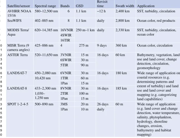
Table 3.1 RS requirements for ocean, estuarine/coastal lagoons and land environments (Adapted from Klemas 2011) Open ocean Estuaries/coastal lagoons Land surface
Spatial resolution 1–10 km 20–200 m 1–30 m Coverage area 2,000 × 2,000 km 200 × 200 km 200 × 200 km Frequency of coverage 1–6 days 0.5–6 h 0.5–5 years
Dynamic range Narrow Wide Wide
Radiometric resolution 10–12 bits 10–12 bits 8–10 bits
Spectral Resolution Multispectral Hyperspectral Multispectral (hyperspectral)
Table 3.2 Characteristics of some current satellite RS systems (Adapted from Klemas 2011) Satellite/sensor Spectral range Bands GSD
Revisit
time Swath width Application AVHRR NOAA
15/16
580–12,500 nm 6 1.1 km −12 h 2,400 km SST, turbidity, circulation SeaWIFS 402–885 nm 8 1.1 km daily 2,800 km Ocean color, red products MODIS Terra/
Aqua
620–14,385 nm 16VNIR 250 m–1 km daily 2,330 km SST, turbidity, circulation, ocean color
4SWIR 16TIR MISR Terra (9
camera angles)
425–886 nm 4 275 m 9 days 360 km Ocean color, circulation ASTER Terra 520–11,650 nm 3VNIR 15 m 16 days 60 km Bathymetry, vegetation, land
use and land cover, change detection, circulation, geomorphology 6SWIR 30 m
5TIR 90 m
LANDSAT-7 450–2,080 nm 6VNIR 30 m 16 days 180 km Wide range of application on coastal resources (e.g. determining patterns and extent of turbidity) and land use and land cover and mapping (e.g. categorizing land capabilities)
10,420 nm 1TIR 60 m 1Pan 15 m
LANDSAT-8 433–2,300 nm 8VNIR 30 m 16 days 185 km 1,030–
1,250 nm
2TIR 100 m 1Pan 15 m
SPOT 1-2-4-5 500–890 nm 3MS 20 m 26 days 60 m Wide range of application (e.g. land cover and change detection, water temperature, salinity, phytoplankton, hydrology, shoreline changes, erosion, bathymetry and habitat mapping)
1Pan 10 m daily
(continued)
small ground features. These findings suggest that while traditional VNIR multispectral imag-ery is vimag-ery capable at classifying water types, the additional spectral bands of WordView-2 pro-vides an incremental improvement in feature classification applications.
Also conventional color satellites sensors such as SeaWIFS and MODIS have proven to be use-ful in retrieving water quality parameters in
ocean waters (Liew et al. 2011). However, such sensors usually are low resolution, of about 1 km. This implies they are not suitable for inland and coastal waters due to land contamination. As pre-viously discussed it is also important the use of high resolution satellite sensors to monitor the water quality of the ecosystems. In comparison to the conventional high resolution satellites such as LANDSAT, SPOT and IKONOS, the additional
F. Gutierres et al. 209 210 211 212 213 214 215 216 217 218 219 220 221 222 223 224 225 226 t1.1 t1.2 t1.3 t1.4 t1.5 t1.6 t1.7 t1.8 t2.1 t2.2 t2.3 t2.4 t2.5 t2.6 t2.7 t2.8 t2.9 t2.10 t2.11 t2.12 t2.13 t2.14 t2.15 t2.16 t2.17 t2.18 t2.19 t2.20 t2.21 t2.22 t2.23 t2.24 t2.25 t2.26 t2.27 t2.28 t2.29 t2.30
spectral bands of WorldView-2 enable more accurate retrievals of water quality parameters from the reflectance values.
3.2.2 Object-Based and Pixel-Based Classifications
The literature regarding the discussion about the difference between Pixel-Based (Supervised and Unsupervised) and OBIA classification has been very active in the last years, and a large number of papers regarding the classification accuracy of this RS techniques have been published (Gutierres
2014; Teodoro and Gonçalves 2011; Weih and Riggan 2010; Gao and Mas 2008; Lillesand et al.
2008; Rahman and Saha 2008; Blaschke and Lang 2006; Hay and Castilla 2006; Hall et al.
2004; Hay et al. 2003; Lang and Blaschke 2003; Foody 2002; Baatz and Schäpe 2000).
The most popular techniques are those based on group pixels – unsupervised and supervised image classifications – to represent land cover features such as wetlands and beaches. There are different image clustering algorithms such as K-means and Iterative Self-Organizing Data Analysis Technique (ISODATA) (Lillesand et al.
2008).
The supervised classification is based on the spectral signature defined in the training set. The most usual supervised classification algorithms are Maximum Likelihood (MLC), Minimum-
Satellite/sensor Spectral range Bands GSD
Revisit
time Swath width Application WorldView-2 450–1,040 nm 8MS 2 1.1–
2.7 days
16.4 km Bathymetry, vegetation, littoral processes, coastal geomorphology, digital elevation models 1pan 0.5 GeoEye-1 450–920 4MS 1.65 2.1– 8.3 days 15.2 km 1Pan 0.41 IKONOS 450–750 4MS 4 m 1–3 days 13 km 1Pan 1 m
Quick bird 2 450–900 nm 4MS 4 m <3 days 22 km 1Pan 1 m Orbview 3 450–900 m 4MS 4 m <3 days 8 km 1Pan 1 m Orbview 4 450–2,500 nm 200HS 8 m <3 days 5 km 450–900 nm 4MS 4 m 1Pan 1 m
ALIEO-1 400–2,400 nm 9MS 30 m 19 days 37 km Bathymetry, vegetation, land use and land cover, change detection, circulation, geomorphology 1Pan 10 m
Hyperion EO-1 400–2,400 nm 220 30 m 16 days 8 km Bathymetry, vegetation, littoral processes NEMO/COIS 400–2,500 nm 210 30 m
MERIS ENVISAT-1
290–1,040 15 300 m <3 days 1,150 km Ocean color, circulation ASAR
ENVISAT-1
C-band 4 pol 2 30 m <3 days 50–100 km Circulation, waves AMI
ERS-2(SAR)
C-band V pol 1 25 m 28 days 100 km RADARSAT-
1(SAR)
C-band H pol 1 6–100 m 1–4 20–500 km Oil spill, internal waves and altimetry RADARSAT- 2(SAR) C-band HV pol 1 3–100 m 20–500 km Table 3.2 (continued) 227 228 229 230 231 232 233 234 235 236 237 238 239 240 241 242 243 244 245 246 247 248 249 250 251 252 253 254 255 t2.31 t2.32 t2.33 t2.34 t2.35 t2.36 t2.37 t2.38 t2.39 t2.40 t2.41 t2.42 t2.43 t2.44 t2.45 t2.46 t2.47 t2.48 t2.49 t2.50 t2.51 t2.52 t2.53 t2.54 t2.55 t2.56 t2.57 t2.58 t2.59 t2.60 t2.61 t2.62 t2.63 t2.64
Fig. 3.1 Subset of LANDSAT-8 scenes from coastal lagoons on the Portuguese southwest coast. Image acquired in 25 May 2015 over ‘Santo André’ lagoon. (a) Natural color composite of the Operational Land Imager (OLI) red (0.64–0.67 μm), green (0.53–0.59 μm) and blue (0.45–0.51 μm). (b) Color infrared (vegetation) compos-ite of the OLI near infrared (0.85–0.88 μm), red (0.64–
0.67 μm) and green (0.53–0.59 μm). (c) Land water composite of the OLI near infrared (0.85–0.88 μm), short-wave infrared (1.57–1.65 μm) and red (0.64–0.67 μm). (d) Six hundred fifty four false color (vegetation analysis) composite of the OLI shortwave infrared (1.57–1.65 μm), near infrared (0.85–0.88 μm) and red (0.64–0.67 μm)
Distance- to-Means (MDM) and Parallelepiped classifiers.
According to Lillesand et al. (2008), the mixed pixels (includes more than one land cover type or feature on the ground) present a difficult problem for image classification, since their spectral characteristics are not representative of any sin-gle feature. Spectral mixture analysis and fuzzy
classification are two procedures designated to deal with the classification of mixed pixels. All of these pixel-based processing methods generate square classified pixels.
Instead, the OBIA classification generates objects of different shape and scale. Hay and Castilla (2006) defines OBIA as a sub-discipline of GIScience devoted to partitioning RS imagery
F. Gutierres et al. 256 257 258 259 260 261 262 263 264 265 266 267 268 269 270 271
Fig. 3.1 (continued)
into meaningful image-objects, and assessing their characteristics through spatial, spectral and temporal scale. At its most fundamental level, OBIA requires image segmentation, attribution, classification and the ability to query and link individual objects (segments) in space and time. Image segmentation is commonly divided into five categories: (a) point-based, (b) edge-based, (c) region-based; (d) combined – watershed and multi-resolution (Fig. 3.3) (Schiewe 2002; Baatz and Schäpe 2000; Pal and Pal 1993).
No matter which of the methods is applied, seg-mentation produces homogeneous image objects by
grouping pixels, and is typical used to locate objects and identify boundaries (Gutierres 2014; Teodoro and Gonçalves 2011; Hay and Castilla 2008; Lang
2008). Several marine/costal studies require the seg-mentation of natural spectral classes such as open water bodies (Lira 2006; McFeeters 1996; Daya-Sabar et al. 1995), wetland habitats (Gutierres 2014), river plume size (Teodoro and Gonçalves 2011; Valente and da Silva 2009; Nezlin et al. 2005; Otero and Siegel 2004), physical differences (e.g. salinity) between the estuarine outflow and the ambient water (Dzwonkowski and Yan 2005), suspended sedi-ments (Nechad et al. 2010; Teodoro et al. 2007a, b;
272 273 274 275 276 277 278 279 280 281 282 283 284 285 286 287 288 289 290 291 292 293 294 295 296 297
Lira et al. 1997) and sand spits (Teodoro and Gonçalves 2011; Bird 2008). So these objects are more meaningful than the traditional pixel-based segmentation because they can be classified based on texture, context and geometry (Teodoro and Gonçalves 2011; Rahman and Saha 2008; Baatz et al. 2001) (Fig. 3.4).
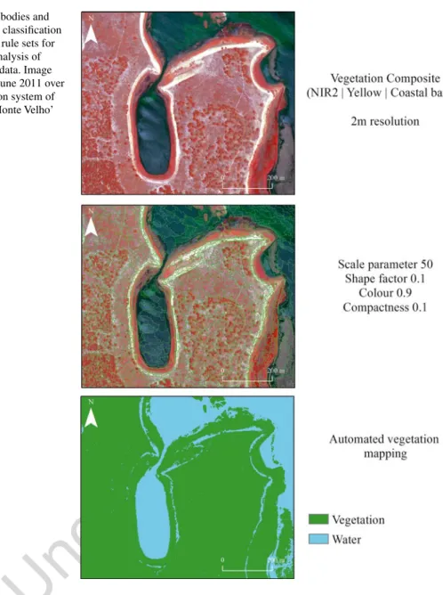
Another advantage is the OBIA allows the use of multiple bands for the multiresolution segmentation and classification (e.g. automated vegetation mapping based on WorldView-2) (Fig. 3.5) (Gutierres 2014).
Weih and Riggan (2010) compared OBIA and Pixel-Based classification, and showed that when
merging a high-spatial resolution color infrared digital orthophoto with multitemporal (winter and spring) medium-spatial resolution SPOT-5 satellites images, an OBIA classification outper-form both supervised and unsupervised Pixel- Based methods. Also the OBIA clearly reduced the “salt and pepper” effect presented in Pixel- Based classification, and may appear more visu-ally attractive to the analyst.
The research developed by Gao and Mas (2008) has shown that with satellite imagery of four different spatial resolutions (SPOT-5, LANDSAT-7 ETM+ and MODIS), OBIA obtained higher accuracies than those of the
Fig. 3.1 (continued) F. Gutierres et al. 298 299 300 301 302 303 304 305 306 307 308 309 310 311 312 313 314 315 316 317 318 319 320 321 322 323 324 325
Pixel-Based one. Thus with the increase of the pixel size (10, 30 and 250 m), OBIA did not show more advantage over the Pixel-Based ones. The authors proved that OBIA has advantage over the Pixel-Based method but the higher accuracy only holds true for high spatial resolution images.
Gutierres (2014) applied a hybrid method (com-bination of Pixel-Based classification and multi-resolution segmentation) and found that the inclusion of image-objects for the Natura 2000 habitat classification lead to higher accuracy levels.
In conclusion, it was recognized that Pixel- Based image analysis reveals limitations because the following reasons:
• Image pixels are not true geographical objects and the pixel topology is limited;
• Pixel-Based image analysis largely neglects the spatial photo-interpretive elements such as texture, context and shape;
• The increased variability implicit within high spatial resolution imagery confuses traditional Pixel-Based classifiers accuracy (Hay and Castilla 2006). Fig. 3.1 (continued) 326 327 328 329 330 331 332 333 334 335 336 337 338 339 340 341 342 343 344 345 346 347 348 349
Fig. 3.2 Sado Estuary land cover classification based on LANDSAT-7 ETM+. Image acquired in 25 April 2010 over Site of Community Importance (SCI) of the Sado Estuary
Fig. 3.3 Multi-resolution segmentation of WorldView-2 image data: water bodies and wetland vegetation are of similar spectral values. Image acquired in 11 June 2011 over the fluvial-lagoon system of ‘Santo André-Monte Velho’
Instead, OBIA is centered on homogeneous objects produced by image segmentation and more elements can be use in classification. Thus object characteristics such as mean and standard deviation values of spectral bands, ratio, etc., can be calculated; besides there are shape and texture properties of the image objects available which can be used to differentiate marine and coastal features with higher accuracy than those pro-duced by the Pixel-Based method.
3.2.3 What Needs to Be Improved Recent advances in sensor design are making RS systems more attractive for assessment of marine
and coastal ecosystems, such as open sea, wet-lands, estuaries, and coastal lagoons. Generally, these ecosystems presents high spatial complex-ity and temporal variabilcomplex-ity, their assessment can be improved from new satellite imagery and air-craft, to allow getting better systematic, spatial, spectral, and temporal resolutions.
Currently we consider that the assessment of marine and coastal ecosystems can be improved considering the launch in June 2015 of the senti-nel- 2 satellite within Copernicus project of the European Space Agency (ESA). This will be an Earth Observation (EO) operational mission pro-viding continuity to LANDSAT data. It has a global coverage of the Earth’s land surface every 10 days with one satellite and 5 days with two
Fig. 3.4 Spatial resolution of the imagery: Low ׀ Medium ׀ High. (a, b) Low-medium spatial resolution – pixels and objects are similar in scale. Traditional pixel-based and object-based image classification techniques perform well. (c) High spatial resolution – objects are made up of several pixels. In this case, object-based image analysis is
superior to traditional pixel based classification. Orthophoto four bands (R, G, B and NIR) of the Tróia Spit acquired in 22 April 2007 (From General Directorate for the Territory (DGT), 2011, with permission)
350 351 352 353 354 355 356 357 358 359 360 361 362 363 364 365 366 367 368 369 370 371 372 373 374 375 376 377 378
satellites that will able to monitor continuously the water quality and flood dynamics.
Further studies with new sensors must be developed for monitoring the marine and coastal areas. The usage of Sentinel-2 sensor, time series of very high resolution imagery (e.g. WorldView-2), hyperspectral sensors, airborne Light Detection and Ranging (LiDAR) systems, Thermal infrared scanners, microwave radiome-ters, Radar images, scatter meradiome-ters, altimeradiome-ters, Unmanned Aerial Vehicle (UAV) and new data analysis techniques can provide the way forward
for future prospects, such as, raise the accuracy of change detection in costal ecosystem health (e.g. wetland biomass change); detailed mapping of sea surface temperatures, salinity and soil moisture; deep analysis of sea surface winds, elevation, currents, wave fields and oil slicks; improvement of shoreline position analysis and beach erosion studies; and a better performance high-resolution three-dimensional measurements of biological and physical ocean features.
Also accurate field data collection approach using ships, buoys, and field instruments with a
Fig. 3.5 Water bodies and vegetation units classification based on OBIA rule sets for the automatic analysis of remote sensing data. Image acquired in 11 June 2011 over the fluvial-lagoon system of ‘Santo André-Monte Velho’
F. Gutierres et al. 379 380 381 382 383 384 385 386 387 388 389 390 391 392 393 394 395 396 397 398 399 400 401 402
valid sampling scheme must be improved to calibrate and/or validate the remotely sensed information.
3.3
Management of Marine
and Coastal Ecosystems
through RS Applications
In this section were provided examples of using RS technologies in applications relevant to man-agement of marine and costal ecosystems needs. Were presented and discussed six cases related to marine/coastal management and monitoring efforts in the Portuguese coast.
3.3.1 Landscape Scale Analysis of Coastal Wetlands Health and Land Cover Changes
Wetlands are ecologically sensitive and dynam-ics ecosystems susceptible to climate and LULC changes, and support high levels of biodiversity. Over the last centuries its conservation status has been neglected, and in several cases have been forced to drainage and transformations. The first international convention on Wetlands of International Importance (formally, the Ramsar Convention was signed in 1971) aimed the con-servation and sustainable utilization of wetlands, recognizing the fundamental ecological func-tions of wetlands (such as water regulation, fil-tering and purification) and their economic, cultural, scientific, and recreational value. The United Nations Millennium Ecosystem Assessment recognizes the global economic value of wetlands (at up 15 trillion USD in 1997) (Bustamante et al. 2013). Such ecosystems include areas with biologically valuable vegeta-tion, such as, peat bogs, marshes and tidal flats. An increasing number of wetlands have some kind of legal protection, such as National Reserves, Site of Community Importance (SCI), Special Protected Zones (ZPE) or Important Bird Areas (IBA)), and several coastal wetlands are constantly monitored and managed (Correia et al. 2012; Freitas et al. 2007).
RS provides useful information and tools to identify long-term trends and short-term varia-tions, such as impact of rising sea levels and LULC changes on wetlands. For instance, Bustamante et al. (2013) mentioned that EO sat-ellites can be used to delineate flooded areas, and can supply complementary information on wet-land location, limits and extent. They can also be used to monitor changes in water quality (cyano-bacterial blooms, trophic status, inputs of terres-trial Carbon), to map habitat types, vegetation communities, to identify long-terms trends and subtle changes of biomass, or ecosystem services (Mücher et al. 2010; Kennedy et al. 2009).
Thus, RS can provide methods to monitor spe-cific biophysical and biochemical indicators of ecosystem functioning (e.g. Leaf Area Index (LAI), Normalized Difference Vegetation Index (NDVI), chlorophyll content, fractional cover, phenology, vegetation height (Mücher 2009; Kerr and Ostrovsky 2003). Many of these param-eters are currently mainly applied at large scales (global, continental), see e.g. the Core Services on Bio-Geophysical Parameters of the EC-funded Geoland project (GMES for Europe), which aim at facilitating policy-supporting applications in the fields of climate change (carbon fluxes), food security (crop monitoring), and global land cover change. The relation of such parameters with the more traditional habitat quality approach at the scale of the habitat patch is still to be investigated.
Changes in wetland vegetative cover, which can be expressed as NDVI, manifest as changes of species composition and productivity, are generally the result of dynamics processes and anthropic induced perturbation. Thus, the NDVI can be related to plant biomass or stress, since the NIR reflectance depends on the abundance of plant tissue and the red reflectance indicates the surface condition of the plant (Klemas
2011). Frequently, these major transitions in wetland systems are preceded by gradual degra-dations of native habitats. These modifications of existent habitats, while not always altering areal extent, can modify the functional health of coastal wetlands. Thus RS would be more use-ful for wetlands research if it could include
403 404 405 406 407 408 409 410 411 412 413 414 415 416 417 418 419 420 421 422 423 424 425 426 427 428 429 430 431 432 433 434 435 436 437 438 439 440 441 442 443 444 445 446 447 448 449 450 451 452 453 454 455 456 457 458 459 460 461 462 463 464 465 466 467 468 469 470 471 472 473 474 475 476 477 478 479 480 481 482 483 484 485 486 487 488 489 490 491 492
some assessment of the functional health of the existing vegetation in addition to any changes in areal extent. The use of remotely sensed data, however, limits the number of possible indica-tors that can be used to monitor the health con-ditions of the wetlands. Fortunately, RS techniques have been successful in mapping one of the most practical indicators of wetland con-ditions over large areas – vegetative abundance, i.e., biomass density (Kennedy et al. 2009).
In this context, Gutierres (2014) make an attempt to elaborate RS indicators of coastal wetlands integrity and trends in Santo André Lagoon. According to Correia et al. (2012), Santo André is the largest lagoon (500 ha) on the Alentejo coastline, belongs to the Santo André and Sancha Natural Reserve, and repre-sents an enclosed brackish water coastal lagoon with temporary connections to the sea by a man-made channel. The existence of fresh and brack-ish waters gives rise to a diverse set of aquatic ecosystems and riparian areas that include small marsh areas, willow plantations, rush and reed beds, bogs, heathland and wetland pastures. The exchange and mixture of saltwater and freshwa-ter is irregular and the lagoon may show daily and seasonal fluctuations, but also long-term variation. Different benthic communities may be present along the annual cycle according to the magnitude of episodic freshwater and sea water inputs.
Therefore the goal of this investigation was to use remotely sensed data in a Geographical Information System (GIS) framework in order to integrate and evaluate Land Use and Land Cover (LULC) changes and wetland conditions indicators which are important for determining and managing wetland health. The specific objectives were:
• To determine whether environmentally stressed wetland areas can be identified through the analysis of a normalized time- series (LANDSAT TM of 1989, 2000, 2007 and 2010), namely by the combination of the NDVI (biomass) maps with ancillary LULC layers (Corine Land Cover (CLC) Changes 1990–2000 and 2000–2006).
• To develop long-term monitoring techniques for evaluation of trends in wetland conditions and thus improve the management of wetland ecosystem.
• To determine if LULC and water quality data in the GIS database can be used to relate water quality changes to changes in sur-rounding land use and nonpoint source pollu-tion loadings.
The biomass abundance maps of Santo André lagoon, obtained through NDVI reclassified into five biomass density classes, revealed useful to identify the most fragile areas, where manage-ment actions for conservation should focus on the future (Fig. 3.6).
Thus, were found that RS techniques can be used effectively in a GIS framework with ancil-lary data to provide valuable information of the management of Santo André lagoon. The strength of RS is its ability to deliver quantita-tive measures of such parameters in a standard-ized manner with full coverage over larger wetland areas, whereas field surveys can only deliver this through point sample measurements and subsequent interpolation. The provision of such data by RS may open new ways of looking at quality of coastal wetlands. This becomes especially relevant as higher resolution, lower cost satellite data become available and RS techniques for analyzing spatial data set improve.
3.3.2 Integration RS in Natura 2000 Habitat Monitoring
Monitoring and reporting on the conservation status at local level, Site of Community Importance (SCI), gained increasing impor-tance in the European Union with the imple-mentation of the Habitat Directive in 1992 (Council Directive 92/43/EEC of 21 May 1992 on the conservation of natural habitats and of wild fauna and flora) (Gutierres et al. 2013; Vanden Borre et al. 2011). According to Article 17 of the Directive, reporting the habitat con-servation status requires detailed knowledge of
F. Gutierres et al. 493 494 495 496 497 498 499 500 501 502 503 504 505 506 507 508 509 510 511 512 513 514 515 516 517 518 519 520 521 522 523 524 525 526 527 528 529 530 531 532 533 534 535 536 537 538 539 540 541 542 543 544 545 546 547 548 549 550 551 552 553 554 555 556 557 558 559 560 561 562 563 564 565 566 567 568 569 570 571 572 573 574 575 576 577 578 579 580 581 582 583
many aspects of Natura 2000 habitats at differ-ent spatial scales (Evans 2006).
According Vanden Borre et al. (2011), RS is seen as an important tool to obtain and analyze synoptic data on Natura 2000 habitats, but cur-rently reflects some limitations for monitoring and reporting purposes.
In fact, the application of RS tools for habi-tat mapping and monitoring offers multiple advantages over traditional field mapping, like faster map production, insight into remote and inaccessible terrain such as coastal wetlands, and improved repeatability of the habitat map-ping process (Blaschke et al. 2008; Lengyel et al. 2008; Groom et al. 2006; Aplin 2005; Bock et al. 2005a, b; Keramitsoglou et al. 2005; Nagendra 2001; Buiten and Clevers 1990).
In the application field of Natura 2000 habi-tat mapping and monitoring, the RS analysis is restricted to pilot studies (e.g. Mücher 2009; Diaz Varela et al. 2008; Förster et al. 2008;
Bock et al. 2005a; Frick et al. 2005). According Bock et al. (2005b), in the past RS techniques fell short in mapping very detailed and particu-lar biotopes like Natura 2000 coastal habitats, but RS capabilities is evolving rapidly, and new methodologies are opening up opportunities for innovative applications of RS data in habitat monitoring (Gross et al. 2009; Aplin 2005; Turner et al. 2003).
Gutierres (2014) produced detailed Natura 2000 habitat maps contained in the fluvial-lagoon system of Santo André-Monte Velho (Fig. 3.7). This lagoon system is included in the ‘Lagoas de Santo André and Sancha Natural Reserve’, which occupies a 15 km-wide coastal sector inland from the shoreline, on the Alentejo coastline in the municipalities of Sines and Santiago do Cacém. The Natural Reserve includes the Lagoa de Santo André (500 ha) and the Lagoa da Sancha (15 ha), a dune system (mobile and stabilized dunes), shrublands and
Fig. 3.6 NDVI (Biomass) change analysis based on LANDSAT-7 ETM+ (1989–2010). Images acquired in 14 March 1989, 24 June 2000, 22 July 2007 and 25 April 2010 over ‘Santo André’ coastal lagoon
584 585 586 587 588 589 590 591 592 593 594 595 596 597 598 599 600 601 602 603 604 605 606 607 608 609 610 611 612 613 614 615 616 617 618 619 620 621 622 623 624 625
Pines formations and a small ponds system with peat bogs and humid shrublands (desig-nated as “Poços”). Its protected status recog-nizes the high ecological value of these two wetlands and their surrounding areas which also include the ridge of dunes that separates them from the ocean and the adjacent seashore.
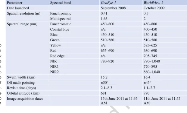
The study was carried out with Very High Spatial Resolution Satellite (VHSR) Imagery – GeoEye-1 and WorldView-2 covering Santo André-Monte Velho lagoon system. Table 3.3
lists the detailed specifications of GeoEye-1 and WorldView-2 satellite images.
In addition to the standard panchromatic and multispectral blue, green, red (visible) and Near InfraRed (NIR1) bands the WorldView-2 sen-sor has:
(a) A shorter wavelength blue band, Coastal Blue, planned for bathymetric studies, can be used for water color analyses and
sub-stantially influenced by atmospheric scattering;
(b) A Yellow band can be used for the assess-ment of the Yellowness of vegetation both on land and water;
(c) A Red Edge band, centered at the onset of the high reflectance portion of vegetation response to potentially significant in the measurement of plant health;
(d) A longer wavelength Near InfraRed band (NIR2), partially overlapping the NIR1 was sensitive to atmospheric water vapor absorption.
Two different approaches were used in order to mapping the Natura 2000 habitats:
1. Based on GeoEye-1 image was developed a spectral separability study and application of the combined approach (spectral and spatial domains), based on pixel-based classification and OBIA (hybrid method).
Fig. 3.7 Mapping the local variability of Natura 2000 habitats with WorldView-2 image data (Image acquired in 11 June 2011 over the fluvial-lagoon system of ‘Santo André-Monte Velho’)
F. Gutierres et al. 626 627 628 629 630 631 632 633 634 635 636 637 638 639 640 641 642 643 644 645 646 647 648 649 650 651 652 653 654 655 656 657 658 659 660 661 662 663 664 665 666
2. The second methodological approach was based on producing habitat maps through Segmentation- based Supervised Classification of the WorldView-2 image data, instead of the pixel-based classification approach.
The detailed methodologies of the hybrid approach and supervised OBIA procedures are presented and compared in Gutierres (2014). The accuracy of the classification maps was estimated using a set of test fields randomly selected on the ground truth map.
This analysis showed that the eight-band sen-sor is extremely useful to better discriminate dif-ferent spectral sub-signatures corresponding to the same habitat category. This means that the major capability of the new sensor resides in the capacity of investigating the ground diversity underlying the apparent homogeneity of conven-tional habitat map. From the Segmentation-based Supervised Classification approach, it was possi-ble to detect changes in the bathymetry for the Sea Water classes by using the Coastal Blue band; moreover, the lowest wavelength band appears to be significant for the recognition of mixed patterns of water and terrain. The Yellow
band appears significant to elicit terrain composi-tion, as characterized by a certain degree of yel-lowness. The Red Edge and the NIR2 bands were useful for a better discrimination of ground sites characterized by a mixing of water and vegeta-tion. The increase in thematic accuracy was 15 %, passing from the traditional four band pro-vided by GeoEye to the new eight-band WorldView-2 sensor. In fact, the overall separability of vegetation classes and water bod-ies was improved with WorldView-2 and significantly after the training data depuration process of coastal habitats. The results obtained proved that the VHSR integration can contribute to the area (location and size) monitoring and also to assess the structure and function (particu-larly regarding structural features) of the Natura 2000 coastal habitats at local scale.
Concluding, the production of coastal habitat distribution maps, at various scale levels, consti-tutes a promising new area for the development of RS applications, as Vanden Borre et al. (2011) indicated. The emergence of hyperspatial and hyperspectral sensors will enhance the analysis of related habitat types at very fine scales (see Haest et al. 2010; Lechner et al. 2009; Mehner
Table 3.3 High-resolution satellite parameters and spectral bands (Satellite Imaging Corporation 2015) Parameter Spectral band GeoEye-1 WorldView-2
Date launched September 2008 October 2009
Spatial resolution (m) Panchromatic 0.41 0.5
Multispectral 1.65 2
Spectral range (nm) Panchromatic 450–800 450–800
Coastal blue n/a 400–450
Blue 450–510 450–510
Green 510–580 510–580
Yellow n/a 585–625
Red 655–690 630–690
Red edge n/a 705–745
NIR 780–920 770–1,040
NIR1 770–895
NIR2 860–1,040
Swath width (Km) 15.2 16.4
Off nadir pointing ±30° ±45°
Revisit time (days) 2.1–8.3 1.1–2.7
Orbital altitude (Km) 681 770
Image acquisition dates 15th June 2011 at 11:35 AM 11th June 2011 at 11:55 AM 667 668 669 670 671 672 673 674 675 676 677 678 679 680 681 682 683 684 685 686 687 688 689 690 691 692 693 694 695 696 697 698 699 700 701 702 703 704 705 706 707 708 709 710 711 712 713 714 715 716 717 t3.1 t3.2 t3.3 t3.4 t3.5 t3.6 t3.7 t3.8 t3.9 t3.10 t3.11 t3.12 t3.13 t3.14 t3.15 t3.16 t3.17 t3.18 t3.19 t3.20 t3.21
et al. 2004). The researchers need such RS-based habitat mapping for estimating range and area of coastal habitats, but also to achieve a better defi-nition and constant updating of the sampling frame for Natura 2000 habitats survey. Indeed, RS technologies represent an important opportu-nity for harmonizing Natura 2000 habitat map-ping throughout Europe.
3.3.3 Quantification of the Total Suspended Matter (TSM) Concentration in Case-2 Waters
Major factors affecting water quality in water bodies across the landscape are suspended sedi-ments, algae, chemicals, DOM, thermal releases, aquatic vascular plants, pathogens, and oils. Satellite sensors with different spectral, spatial, and temporal resolutions have been used to eval-uate chemical pollutants, suspended solids, and chlorophyll abundance (Godin et al. 1993).
The dominant optically active constituent in the open sea (case-1 waters) is the chlorophyll, whereas in the coastal waters (case-2 waters), sediments and DOM often dominate the spectral signal of chlorophyll (Myint and Walker 2002). The study of suspended matter has an ecological importance, because the suspended matter is the main carrier of various inorganic and organic substances and becomes the main substrata for biochemical processes (Doeffer et al. 1989). The TSM concentration affects ocean/coastal produc-tivity, water quality, navigation, and coastal defense. The TSM concentration and distribution in the coastal zone varies with several hydrody-namic factors, such as tidal condition, currents direction and velocity, river discharges, and wind stress (Teodoro et al. 2007b). The discrimination of TSM from water reflectance is based on the relationship between the scattering and absorp-tion properties of water and its constituents. In the visible and NIR region, most of the scattering is caused by suspended sediments, and the absorption is controlled by chlorophyll-a and col-ored DOM. These absorptive in-water compo-nents decrease the reflectance in a substantial
way. However, these absorptive effects occur generally for wavelengths less than 500 nm (Myint and Walker 2002). The visible and NIR regions are the most adequate to estimate the TSM concentration.
Several works have demonstrated that remotely sensed data can be used to retrieve TSM concentration from turbid coastal waters (e.g. Nechad et al. 2010; Ouillon et al. 2008; Miller and Mckee 2004). Moreover, various studies have been carried out combining in situ measure-ments and satellite data in order to relate spectral properties of seawater and TSM concentration (e.g. Chen et al. 2014; Teodoro et al. 2008). Many TSM models based on empirical methods have been used in operational satellite RS systems. These models were developed on the basis of sta-tistical relationships between TSM concentra-tions and single-bands or multi-bands reflectance. For instance, Doxaran et al. (2002), Islam et al. (2001), Forget and Ouillon (1998), and Ritchie et al. (1974) established empirical relationships between reflectance of visible and NIR bands of satellite data and TSM concentration. Aguirre- Gomez (2000) investigates the linear relationship between in situ measurements of TSM concen-tration, collected by ship, and remotely sensed data provided by AVHRR. Although empirical models may be effectively applied to satellite images concurrent with the calibration dataset, their accuracy may be reduced outside the condi-tions of the calibration dataset because of the empirical basis (Nechad et al. 2010). Therefore, semi-analytical models which combine physical methods with statistical methods were proposed for several authors in order to retrieve the TSM concentration (e.g. Chen et al. 2014, 2013; Ouillon et al. 2008).
Teodoro et al. (2007b) retrieve the TSM con-centration from multispectral satellite data (LANDSAT TM, SPOT HRVIR and ASTER) by multiple regression and Artificial Neural Networks (ANN) for a very dynamic area of coastal zone: the breaking zone. In this work, a part of the northwest coast of Portugal, around Aveiro city, was chosen as a study site. This area is limited to the North by the Douro River mouth and to the South by Mira Lagoon (Fig. 3.8).
F. Gutierres et al. 718 719 720 721 722 723 724 725 726 727 728 729 730 731 732 733 734 735 736 737 738 739 740 741 742 743 744 745 746 747 748 749 750 751 752 753 754 755 756 757 758 759 760 761 762 763 764 765 766 767 768 769 770 771 772 773 774 775 776 777 778 779 780 781 782 783 784 785 786 787 788 789 790 791 792 793 794 795 796 797 798 799 800 801 802 803 804 805 806 807 808 809 810
The total extension of this area is about 80 km with an orientation NNE-SSE. The littoral drift current act principally in the North-south direc-tion. The wave climate has medium significance with wave heights from 2 to 3 m and periods ranging from 8 to 12 s. Tides are of semidiurnal type, reaching a range of 2–4 m for Spring tides. Meteorological tides are not significant.
There is a general consensus that, in cases when waves are breaking, the sediment transport tends to be directed offshore due to the seaward-
directed undertow generated by wave breaking and radiation-stress decay (Aagaard et al. 2002). This fact presents a huge challenge for the researches. Over the last decades, the phenome-non of coastal erosion had been increasing pro-gressively almost in all world coastal areas. The main causes of this serious environmental prob-lem have been identified as a coastal response to the weakening of the river basin sediment sources and river-sediment transport, the mean sea-level rise, the human occupation of the waterfront, and dune destruction. Therefore, the determination of the TSM concentration around the breaking zone would provide meaningful information to esti-mate the sedimentary balance in this area.
Two different approaches were followed in order to relate the TSM concentration with the spectral response of the breaking zone water: field surveys and satellite images. In the field work different techniques were tested: maritime platforms, aerial platforms, simulations on the beach, and water samples collection in the break-ing zone. It was very difficult get water samples and simultaneous radiometric measurements in the breaking zone. Therefore an evaluation of the range of TSM values, typically found in this area, need to be obtained through simulations on dif-ferent beaches of the study area (Teodoro et al.
2007a, 2008; Teodoro and Veloso-Gomes 2007).
In these simulations the bubbles and turbulence presented in the breaking zone were considered. A FieldSpec FR spectroradiometer was used to determine the seawater reflectance. Figure 3.9
shows the reflectance spectra (R(λ)) obtained for a range of TSM concentration with values between 14 and 449 mg/l. After, the seawater reflectance measured by the spectroradiometer was converted for the seawater reflectance recorded from ASTER, SPOT HRVIR, and LANDSAT TM in the visible and NIR bands. All satellite-image bands from visible and NIR were first calibrated for radiance values and, subse-quently, for reflectance values. The atmospheric- correction procedure was based on an improved DOS technique (Chavez 1988). All satellite images were geometrically corrected using the ground-control points (GCPs) provided in the image header and further adjusted with GCPs
Fig. 3.8 Study area located between the River Douro mouth and Mira Lagoon (Teodoro and Veloso-Gomes
2007) 811 812 813 814 815 816 817 818 819 820 821 822 823 824 825 826 827 828 829 830 831 832 833 834 835 836 837 838 839 840 841 842 843 844 845 846 847 848 849 850 851 852 853 854 855 856 857 858 859 860 861 862 863 864 865 866 867 868 869
collected in the field. The Root Mean Square (RMS) error was, for all the images, less than 1 pixel.
Three different approaches were considered in order to quantify the TSM concentration through seawater reflectance. First, single band models were proposed, and equations of linear, polyno-mial, logarithmic, power, and exponential models were applied for all equivalent satellite-image bands. The linear and polynomial models pre-sented higher determination coefficient (R2 > 0.96) than logarithmic, power, and expo-nential models (0.63 < R2 < 0.94). However, the same linear models presented a Mean Absolute Error (MAE) values ranging from 20.68 to 29.28 mg/l.
After, several multiple regressions were estab-lished for the three sensors tested. The values of the dependent (TSM concentration) variable and the independent (visible and NIR reflectance, in percent) variables were used to estimate the model coefficients. The combination of the green and red bands presented high correlation coeffi-cient values for all sensors, so this combination was discarded. The RMS error was too high,
around the same TSM concentration values expected for the breaking zone (between 20 and 30 mg/l). Considering the previous results and the apparent non nonlinearity verified between the reflectance and TSM concentration, an ANN were implemented. Gan et al. (2004) have already used artificial neural networks (ANNs) to retrieve the seawater optically active parameters from multispectral and hyperspectral data. The train-ing set of this paper consists of 11 values of reflectance of the visible and NIR channels for each sensor (inputs) and their corresponding TSM concentration values (output), already con-sidered for the two previous methodologies. An ANN is a parallel-distributed processor that resembles the human brain by acquiring knowl-edge through a learning process and, then, stores the knowledge in the connection strength between computational units called neurons, and com-prises several layers: an input layer; an output layer; and one or more hidden layers between them. The weights of the ANN based on the back-propagation algorithm and the leave-one- out method of error estimation. More information could be founded in Haykin (1999). Three ANN
14 12 10 8 Reflectance (%) 6 4 2 0 400 500 600 Wavelength (nm) 700 800 900 TSM (mg/l) 449 433 339 290 166 144 119 51 45 17 14
Fig. 3.9 Relationship between TSM concentration and seawater reflectance based on simulations on different beaches of the study area (Teodoro et al. 2007b)
F. Gutierres et al. 870 871 872 873 874 875 876 877 878 879 880 881 882 883 884 885 886 887 888 889 890 891 892 893 894 895 896 897 898 899 900 901 902 903 904 905 906 907 908 909 910 911 912 913 914 915 916 917 918 919
were implemented (one for each sensor). The training set of this paper consists of 11 values of reflectance of the visible and NIR channels for each sensor (inputs) and their corresponding TSM concentration values (output). The hidden layer contains ten neurons. The algorithm stops when the RMS error is not greater than 2E-03 mg/l (an acceptable error). The final RMS errors were 1.5E-03, 4.2E-04, and 2.0E-03, for ASTER, SPOT HRVIR, and LANDSAT TM. The best results were found for ASTER and SPOT HRVIR images. In the Fig. 3.10 is presented the TSM concentration values estimated for the SPOT HRVIR image. The results are very satisfactory, as can be showed, with the discrimination between cases 1 and 2 waters and the identifica-tion of rip currents.
Concluding, the analysis of the RMS errors, achieved by both linear and nonlinear models, supports the hypothesis that the relationship between seawater reflectance and TSM concen-tration is clearly nonlinear. The ANNs have been shown to be useful in estimating the TSM con-centration from the reflectance of visible and NIR bands from ASTER, SPOT HRVIR, and
LANDSAT TM sensors, with better results for ASTER and SPOT HRVIR sensors. The nonlin-earity verified between the reflectance and TSM concentration could also be related to the accu-racy of the satellite-derived water leaving reflec-tance (atmospheric correction and calibration procedure) and also from the natural variability of water leaving reflectance from factors not directly related to TSM, such as DOM absorption or phytoplankton absorption. The accuracy of this work can be improved by enlarging the data set, synchronizing the simulations on the beach and satellite images.
3.3.4 Identification,
Characterization and Analysis of River Plumes
River discharge into the coastal ocean represents a major link between terrestrial and marine sys-tems. River plumes are an important phenome-non in coastal regions. In areas with high rates of river discharge, plumes clearly influence coastal dynamics. River plumes are a mixture of fresh
Fig. 3.10 TSM concentration estimated by the ANN implemented, considered the SPOT HRVIR image 920 921 922 923 924 925 926 927 928 929 930 931 932 933 934 935 936 937 938 939 940 941 942 943 944 945 946 947 948 949 950 951 952 953 954 955 956 957 958 959 960 961 962 963 964 965 966
water and river sediment load, with some dilution caused by currents. The river plumes are distin-guished from surround marine waters by their high concentration of total TSM which changes the color of the ocean surface. Since the TSM concentration can be associated with nutrients, pollutants and other materials, it is of crucial importance to remotely survey their dispersal in order to assess the environmental quality of the regions surrounding river mouths.
Satellite RS can provide frequent, large scale, near-surface views of the coastal ecosystem. High quality ocean color products over global open oceans are currently being produced for researchers and scientists to study and under-stand ocean physical, optical, and biological changes and their effects on the climate pro-cesses. However, due to physical, bio-optical, and environmental complexities of the coastal turbid waters, satellite-derived ocean color data from standard products are often biased in coastal ocean regions.
The most commonly used satellite data for river plume observations/quantification included data from AVHRR (e.g. Otero et al. 2009), SeaWiFS (e.g. Son et al. 2012; Mertes and Warrick 2001), MODIS (Fernández-Nóvoa et al.
2015; Mendes et al. 2014; Ondrusek et al. 2012; Shi and Wang 2009; Warrick et al. 2007), MERIS (Teodoro et al. 2009a) or combining data from different sensors (e.g. Jiang et al. 2009; Hendiarti et al. 2004; Warrick et al. 2004; Hu et al. 2003).
Some work has also been done using satellite sensors with higher spatial resolutions such as LANDSAT TM and ETM plus images (e.g. Guneroglu et al. 2013; Rudorff et al. 2011; Hellweger et al. 2004; Lira et al. 1997) or SPOT data (e.g. Doxaran et al. 2002; Ouillon et al.
1997). Although the increased spatial resolution provides vastly greater structural detail within the plume signatures, the low temporal resolution (approximately 2 weeks), makes image availabil-ity after a storm event a major limitation.
The Douro river is one of the longest rivers in the Iberian Peninsula and represents the most important freshwater input into the Atlantic Ocean in the north western Portuguese coast. The Douro river is a granitic drowned valley river,
draining to the N-W shore of Portugal, and its basin is the largest hydrographical basin in the Iberian Peninsula. This estuary is located on the Western Portuguese coast and is subject to North Atlantic meteorological and hydrodynamic con-ditions. The narrow Douro estuary is limited 21.6 km upstream by the Crestuma dam.
Several studies address coastal upwelling and the dynamics of the Western Iberian Buoyant Plume under several scenarios (e.g. Otero et al.
2008, 2009). Mendes et al. (2014) develop an ad- hoc methodology to observe and characterize the Douro plume and its spatial and temporal vari-ability by using MODIS long-term ocean-color satellite data (2003–2011) and concurrent in situ wind, tidal and river discharge data. However, little attention has been given to the influence of the Douro Estuary (Fig. 3.11) input into the coastal adjacent areas. A preliminary study on the modeling of the Douro River Plume (DRP), Douro River, Porto, Portugal, size obtained through image segmentation of MERIS data has been performed based on 21 MERIS scenes cov-ering approximately 2 years (Teodoro et al.
2009a). More recently, a similar study of the river
plume size with a larger dataset of more recent images (the hydrological year starting at October 2008) was also performed (Teodoro and Almeida
2011; Teodoro and Gonçalves 2011). Gonçalves et al. (2012) presents a work where a fully auto-matic method for the identification of the Douro river plume is proposed, as well as a more com-plete characterization of the river plume, through several attributes associated with shape and TSM concentration. The MERIS images comprise a band with the TSM concentration values, which are retrieved through an algorithm carried out by an ANN, trained to emulate the inverse model (Schiller and Doerffer 2005). In previous works on the same study area, it was found that the TSM concentration values provided by MERIS may be considered valid, despite the lack of in situ validation (Teodoro et al. 2009a; Teodoro and Almeida 2011). MERIS images from the year of 2009 were considered to analyze the TSM concentration. Among the 133 available images covering the study area, only 71 MERIS FR scenes (level 2 data) were considered valid for
F. Gutierres et al. 967 968 969 970 971 972 973 974 975 976 977 978 979 980 981 982 983 984 985 986 987 988 989 990 991 992 993 994 995 996 997 998 999 1000 1001 1002 1003 1004 1005 1006 1007 1008 1009 1010 1011 1012 1013 1014 1015 1016 1017 1018 1019 1020 1021 1022 1023 1024 1025 1026 1027 1028 1029 1030 1031 1032 1033 1034 1035 1036 1037 1038 1039 1040 1041 1042 1043 1044 1045 1046 1047 1048 1049 1050 1051 1052 1053 1054 1055 1056 1057 1058 1059 1060 1061 1062
the identification of the plume (the others were discarded due the presence of clouds or other atmospherics effects).
Two approaches were employed in order to identify the DRP: manual and automatic. The manual identification of a river plume may become a quite subjective task due to the high degree of subjectivity of human intervention. In order to achieve a basis of comparison and prove the high degree of subjectivity of this approach, a manual identification of the river plume was independently performed by two experienced operators in a GIS environment.
The automatic identification of the DRP was performed through a segmentation approach. In previous works on this subject, it was evidenced that image segmentation methods based on the image domain (pixel values) are more appropri-ate to extract the river plume from MERIS data than feature-based methods (Teodoro et al.
2009a; Teodoro and Almeida 2011). The region-
based approach proposed in Teodoro et al.
(2009a) indicated fixed values for the seed (S)
and threshold (T) parameters, as they were appro-priate for MERIS images with a clear saturation of TSM values in the plume region. In this work, a fully automatic method was considered.
Initially, the MERIS images with original TSM concentration values are taken. The advantage of considering the TSM concentration values instead Log10 (TSM) relies on a better discrimi-nation of the plume with respect to its surround-ing pixels, since the logarithm reduces the separability between the plume and surrounding concentration values. The first step is based on thresholding the image based on a certain cutoff (TSMcutoff), which is associated with the highest correlation between the size of the obtained object (river plume) with the river discharges. It was found that a TSMcutoff equal to 2 is adequate for the study area and its current environment. For other study areas and conditions, a sensitivity analysis on the variation may be performed in order to find the most appropriate value. More details about the sensitivity analysis performed could be founded in Gonçalves et al. (2012). After the thresholding operation, the segmenta-tion result is refined by filling the holes of the detected objects. Finally, the river plume is con-sidered to be the object with the largest area.
A comprehensive characterization of the plume was performed through a set of attributes, which take into account not only the shape of the river plume, but also (Fig. 3.12): size of the
Fig. 3.11 TSM concentration retrieved from first MERIS scene of 8 March 2003 for the study area 1063 1064 1065 1066 1067 1068 1069 1070 1071 1072 1073 1074 1075 1076 1077 1078 1079 1080 1081 1082 1083 1084 1085 1086 1087 1088 1089 1090 1091 1092 1093 1094 1095 1096 1097 1098 1099 1100 1101 1102 1103 1104 1105 1106 1107 1108 1109 1110 1111 1112 1113 1114 1115 1116
Fig. 3.12 Time-series of the river plume shape attributes Size, Perimeter, ellipsemajor, elippseminor, the ratio between ellipsemajor and elippseminor (ARat) and orientation (θ) per-taining to the manual identification of operator A (.),
man-ual identification of operator B (x) and automatic identification (o) of the river plume (Gonçalves et al.
2012) [AU3]
plume; perimeter (in number of pixels); the major and the minor axis length of the ellipse adjusted to the river plume; and the orientation, (in degrees). With respect to the TSM concentration values of the pixels within the river plume, the following attributes were considered: average, standard-deviation, maximum, and the sum of all pixel concentrations. Also, in order to relate the plume attributes with environmental parameters, the Douro river discharges (at nearest dam – Crestuma dam), the tide level at Leixões (tide gauge closest to the study area), wind instanta-neous speed and wind direction values were con-sidered for the same time.
The results of the manual and automatic pro-cedures are presented and compared. The statisti-cal analysis was based on the bi-dimensional analysis of the variables of this study, and relied on the computation of the Pearson correlation coefficient.
Regarding, the manual identification, the results obtained by the two operators were simi-lar. Among the considered environmental vari-ables, the river discharges presented correlation values above 0.5 with several attributes of the plume. Although moderate, a negative and sig-nificant correlation was also found between wind speed and minor axis length of the ellipse adjusted to the river plume, and also between wind speed and the average TSM concentration of the plume.
Considering the automatic plume identifica-tion, it was observed that more significant corre-lation are obtained between environmental variables and river plume attributes than what was observed with the manual procedure. In par-ticular, a moderate yet significant and negative correlation was found between wind speed and perimeter, as well as between wind speed and the major and minor axis of the adjusted ellipse. A high correlation of 0.719 was found between the size of the river plume and the river discharges. The results previously presented suggest that important considerations regarding sedimentary balance can be pointed. It can be observed that the higher river discharges are associated with plumes oriented toward the NW-N direction (cor-responding to the range to −45° to −90°). The higher river discharges throw the plume of
sedi-ments with more intensity towards east, which then reaches the poleward current and move towards north. The plumes with positive orienta-tion in the range 45–90° (towards the SW-S direction) are mostly associated with lower river discharges and are pushed by the littoral drift cur-rent (north-south direction). Focusing on the range of river discharges above 500 m3/s, the relation between the orientation attribute and the river discharges appear to present a negative exponential decay. These are important consider-ations which should be taken into account in coastal studies on sedimentary balance and may have important consequences on the natural sup-ply of sediments to feed the beaches of the study area.
Concluding, although MERIS data showed to be a useful data source for the spatio-temporal analysis of the Douro river plume and present a high temporal covarage, other sources of RS data may also be considered in the future. Furthermore, it is necessary to calibrate the reflectance values for TSM concentration values through complex algorithms and also to perform in situ validation. Due the construction of two breakwaters at the mouth of the Douro River (between 2004 and 2008), it is clearly visible that the output of sedi-ments into the sea is quite narrower, which means that the TSM concentration values found in the plume are smaller. The objectives of this study were the development of a method for the auto-matic identification of the Douro river plume from MERIS data, a comprehensive characterization of the river plume, and the spa-tio-temporal analysis of the river plume and its relation with some environmental variables. The advances in the field achieved by the present work support the interest of further research on this topic, namely the employment of more com-plex statistical methods and variables to explore other important considerations in this thematic. 3.3.5 Extraction of Estuarine/
Coastal Sandy Bodies
A sand spit is a deposition landform along coasts, mainly caused by dominant littoral drift and wave action. A sand spit does not present a well-
1117 1118 1119 1120 1121 1122 1123 1124 1125 1126 1127 1128 1129 1130 1131 1132 1133 1134 1135 1136 1137 1138 1139 1140 1141 1142 1143 1144 1145 1146 1147 1148 1149 1150 1151 1152 1153 1154 1155 1156 1157 1158 1159 1160 1161 1162 1163 1164 1165 1166 1167 1168 1169 1170 1171 1172 1173 1174 1175 1176 1177 1178 1179 1180 1181 1182 1183 1184 1185 1186 1187 1188 1189 1190 1191 1192 1193 1194 1195 1196 1197 1198 1199 1200 1201 1202 1203 1204 1205 1206 1207 1208 1209 1210 1211