Land use, land cover, and prevalence of
canine visceral leishmaniasis in Teresina,
Piauí State, Brazil: an approach using
orbital remote sensing
Uso e cobertura do solo e prevalência de leishmaniose
visceral canina em Teresina, Piauí, Brasil:
uma abordagem utilizando sensoriamento
remoto orbital
Uso y cobertura del suelo y prevalencia de
leishmaniosis visceral canina en Teresina, Piauí,
Brasil: un enfoque utilizando teledetección
Anna Barreto Fernandes Figueiredo 1 Guilherme Loureiro Werneck 2,3 Maria do Socorro Pires e Cruz 4 João Pereira da Silva 5 Andréa Sobral de Almeida 6
Abstract
This study examines the association between land use and land cover and the occurrence of canine visceral leishmaniasis (VL). This is a case-control study in which cases were households with seropositive dogs for canine VL and con-trols were households with seronegative dogs. We used remote sensing images (CBERS: 2/CCD and 2B/HRC) to describe land use and cover in squares of 625m2 in the study area. Odds of canine VL were twice as high in
house-holds located in squares with an area ≤ 25m2 covered by residential structures
with little vegetation in comparison to those where the cover reached ≥ 600m2.
Households located in squares with up to half of the area covered by residen-tial structures with extensive vegetation showed 65% lower odds of canine VL in comparison to those situated in areas almost totally covered by this charac-teristic. Since canine infection usually precedes the occurrence de human cas-es, identification of the characteristics of land use and cover associated with canine VL can contribute to the demarcation of risk areas for human VL.
Visceral Leishmaniasis; Dogs; Remote Sensing Technology
Correspondence G. L. Werneck
Instituto de Estudos em Saúde Coletiva, Universidade Federal do Rio de Janeiro.
Av. Horácio Macedo s/n, Rio de Janeiro, RJ 21941-598, Brasil. [email protected]
1 Instituto Nacional de Infectologia Evandro Chagas, Fundação Oswaldo Cruz, Rio de Janeiro, Brasil.
2 Instituto de Estudos em Saúde Coletiva, Universidade Federal
do Rio de Janeiro, Rio de Janeiro, Brasil.
3 Instituto de Medicina Social, Universidade do Estado do Rio de Janeiro, Rio de Janeiro, Brasil.
4 Departamento de Morfofisiologia Veterinária, Universidade
Federal do Piauí, Teresina, Brasil.
5 Gerência de Controle de Zoonoses, Fundação Municipal de Saúde de Teresina, Teresina, Brasil.
6 Escola Nacional de Saúde Pública Sergio Arouca, Fundação
Oswaldo Cruz, Rio de Janeiro, Brasil.
Introduction
Visceral leishmaniasis (VL) is considered one of the world’s major public health problems, causing some 200,000 to 400,000 new cases and 20,000 to 40,000 deaths per year 1. In Latin America, the
disease has been reported in at least 11 countries, with 90% of cases occurring in Brazil, which has reported cases in 21 of the 27 states and an incidence rate of 2 cases per 100,000 inhabitants 1.
In the New World, the etiological agent of VL is protozoans of the species Leishmania infantum (syn.
Leishmania chagasi), with the sand fly Lutzomyia longipalpis as the principal vector in Brazil 2.
Transmis-sion occurs from bites by female sand flies that have ingested blood from an infected mammal. Brazil is experiencing a clear process of urbanization of the disease, due to a series of environmen-tal, social, and economic factors, especially poor sanitation and health conditions and deforestation associated with disordered occupation of peripheral areas of cities by large population contingents
3. In this context, the vector Lu. longipalpis plays a central role in maintaining the urban transmission
cycle, since it is one of the few sand fly species that has adapted readily to the domiciliary and peri-domiciliary environment 4.
Dogs (Canis familiaris) have been incriminated as the parasite’s principal domestic reservoir in urban areas, providing the basis for culling infected dogs as one of the control strategies for VL in Bra-zil 5, although the strategy has not produced the desired effect of interrupting spread of the disease,
besides the relative lack of studies demonstrating its effectiveness 6,7. Even given the known
impor-tance of dogs as a key source of the infection in urban areas, there are still huge gaps in the knowledge on factors associated with L. infantum infection in these animals 8.
Most studies to date on these reservoirs have tended to focus more on the animals’ individual characteristics, such as sex, age, breed, size, and others, rather than socio-environmental aspects associated with the infection 8.
Given the above, the current study aimed to examine the role of environmental factors related to urban occupation in the occurrence of infection with L. infantum in dogs, using remote sensing (RS) images.
Methods
Study area
The study was conducted in the neighborhood of Angelim, located in Teresina, capital of Piauí State (Figure 1). Angelim is an area of urban sprawl in Teresina occupying lands that formerly belonged to the ranch called Fazenda Angelim. The area is characterized by rapid, disordered growth. In 1991 there were only 12 inhabitants. By 2000 there were 14,395 inhabitants, increasing to 19,559 in 2010 (Prefeitura de Teresina. Teresina, perfil dos bairros: Angelim. http://semplan.teresina.pi.gov.br/wp-content/uploads/2014/09/ANGELIM.pdf, accessed on 29/Apr/2015). In the first decade of the 21st century, more than 100 autochthonous cases of human VL were reported in the Angelim neighbor-hood, corresponding to nearly 10% of all cases in the city of Teresina.
Study design
This was a case-control study in which cases (n = 99) were defined as households with at least one dog infected with L. infantum and controls (n = 453) were households with uninfected dogs. The study was designed to assess the association between peridomiciliary socioeconomic and environmental factors and canine infection with Leishmania9. The current article uses data from this study to assess
Data and variables
• Data source
Canine data were obtained from the zoonotic disease control service by consulting the standardized forms from the seroepidemiological survey conducted in 2007 in the Angelim neighborhood. These forms contained the animal’s name, sex, and age, owner’s name, household address, and result of the serological test.
• Diagnosis of infection
The forms from the seroepidemiological survey included the results of the canine serological tests, which had used indirect immunofluorescence reaction with the Bio-Manguinhos kit (Oswaldo Cruz Foundation, Rio de Janeiro, Brazil). Samples that displayed fluorescence in dilution starting at 1:40 were considered positive, and those that did not display fluorescence were considered negative.
Figure 1
• Assessment of covariables
Interviews were held with the dog owners in the selected households, using a questionnaire with items on socioeconomic conditions, housing structure, presence of dogs and other animals in the household and peridomicile, and presence of animal shelters.
These data were used to generate four indicators potentially associated with the likelihood of
Leishmania transmission: (1) head-of-household’s schooling (incomplete primary versus more school-ing); (2) environmental vulnerability index (linear combination of information on adequacy versus inadequacy of sewage disposal, running water, and accumulation of garbage in the peridomicile); (3) household vulnerability index (linear combination of information on household’s adequacy versus inadequacy in terms of existence of masonry walls, cement or tile roof, and ceiling materials); (4) pres-ence of domestic animals and related outbuildings and other constructions (linear combination of information on presence or absence of cats, poultry, pigs, horses, sheep, and/or goats, among others, and presence or absence of kennels and chicken coops).
• Measurement of environmental variables by remote sensing
a) Images used
Environmental information was gathered from satellite scenes (CBERS 2/CCD) from July 2006, with spatial resolution of 20m and from CBERS 2B (HRC) from October 2008, with spatial resolution of 2.5m, available on the website of the Brazilian National Institute for Space Research (INPE).
b) Image processing
The point of departure was recording of the CBERS 2 image (CCD) from July 2006, through the Landsat satellite image of June 5, 2006, available on the website Global Land Cover Facility (GLCF) of NASA (National Aeronautics and Space Administration). Recording used the image recording routine from the SPRING software package (INPE, São José dos Campos, Brazil) 10.
After the recording, the CBERS 2 (CCD) and CBERS 2B (HRC) images were merged to form a multispectral image with high spatial resolution using the IHS (intensity-hue-saturation) method. IHS fusion consists of performing a combination of images in the red (R), green (G), and blue (B) system to produce the component parts: intensity (I), which represents the total energy involved; hue (H), representing the dominant color or measure of the mean light wavelength reflected or transmitted; and saturation (S), expressing the wavelength interval around the mean wavelength, in which the energy is reflected or transmitted. Having obtained these components, one replaces component I with the panchromatic image with the best spatial resolution in the return procedure to the RGB domain. Thus, the spectral information from the RGB composition is integrated with the spatial information from the panchromatic band 11,12.
From this perspective, IHS fusion allows merging the best spatial resolution of the panchromatic band with the best spectral resolution of the other bands, producing a colored image that combines both characteristics.
Image classification aimed to extract variables referring to “land use and land cover”. Land use and land cover are interrelated but intrinsically different concepts: land cover results from the land’s use 13,14. Land cover includes the land surface’s biophysical characterization and can involve, for
example, type and amount of vegetation, water bodies, buildings, and paving. Meanwhile, land use refers to the forms and purposes for which humans use the land and its resources, including agricul-ture, conservation and preservation of areas, and built-up structures for commercial or residential purposes, among others 14,15.
There are major difficulties in producing separate maps for “land use” and “land cover”, especially based on a single RS image, since the two have different temporal characteristics. For example, since “land cover” can vary rapidly, it tends to be defined at a specific moment in time, while “land use” needs to be evaluated over longer time periods 13,14. Despite these differences, land cover maps allow
on a single RS image, the assumption was that the proposed classification presents “land use” and “land cover” characteristics simultaneously, and that there is no practical way to distinguish between the two in this context.
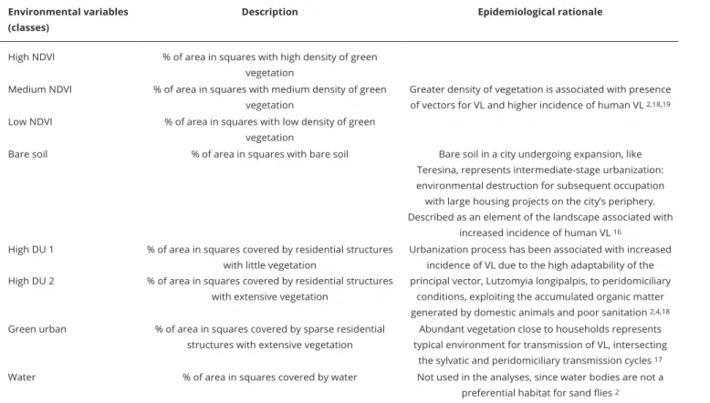
Table 1 describes the eight target classes of “land use and land cover”, as well as the epidemiological rationale for the use of each in this study’s context 2,4,16,17,18,19. To obtain these classes of “land use and
land cover”, we conducted an object-based image analysis (OBIA) with five stages: characterization of the classes, segmentation of the image, elaboration of the semantic network, classification, and evaluation of the results.
The image classification procedure, performed with the Definiens 7.0 package (http://www. definiens.com/), included basically two steps: multiresolution segmentation and algorithmic clas-sification with fuzzy and Boolean logic. This approach uses combinations of spectral, textural, and contextual/topological information. In segmentation, objects are created on different scales accord-ing to criteria of shape, color, and homogeneity, interconnected. In classification, the objects relate with each other by means of the definition of a hierarchical network (legacy of the attributes describ-ing the class) and semantic network (logical structure of the relationship between the classes). Thus, object-based analysis is performed through analysis of segments of the image (objects), and not only of the pixels. Objects with common characteristics are grouped in classes, and the classes are organized as a hierarchical and semantic network. OBIA uses spatial information in its processing and has thus proven more efficient in applications in urban areas 16.
Figure 2 shows the semantic network and levels of segmentation and classification used in the classification process. Level 1 aimed to discriminate between the super-classes “Water” and “Non-water” in the study area. Level 2 separated the superclass “Non-water” into “Vegetation” and
Table 1
Description of environmental variables used in the study on canine visceral leishmaniasis and epidemiological rationale for their use.
Environmental variables (classes)
Description Epidemiological rationale
High NDVI % of area in squares with high density of green
vegetation
Greater density of vegetation is associated with presence of vectors for VL and higher incidence of human VL 2,18,19
Medium NDVI % of area in squares with medium density of green
vegetation
Low NDVI % of area in squares with low density of green
vegetation
Bare soil % of area in squares with bare soil Bare soil in a city undergoing expansion, like
Teresina, represents intermediate-stage urbanization: environmental destruction for subsequent occupation with large housing projects on the city’s periphery. Described as an element of the landscape associated with
increased incidence of human VL 16 High DU 1
High DU 2
% of area in squares covered by residential structures with little vegetation
% of area in squares covered by residential structures with extensive vegetation
Urbanization process has been associated with increased incidence of VL due to the high adaptability of the principal vector, Lutzomyia longipalpis, to peridomiciliary
conditions, exploiting the accumulated organic matter generated by domestic animals and poor sanitation 2,4,18
Green urban % of area in squares covered by sparse residential
structures with extensive vegetation
Abundant vegetation close to households represents typical environment for transmission of VL, intersecting
the sylvatic and peridomiciliary transmission cycles 17
Water % of area in squares covered by water Not used in the analyses, since water bodies are not a
preferential habitat for sand flies 2
“Anthropic area”. In Level 3, the levels of the Normalized Difference Vegetation Index (NDVI) were used to divide the superclass “Vegetation” into the classes “High NDVI”, “Medium NDVI”, and “Low NDVI” according to the vegetation cover’s conditions and density. The “Anthropic area” superclass was also subdivided into the classes “Bare soil” and “Green urban” area; a superclass was also created to represent “Dense urban” area. In Level 4, the superclass “Dense urban” was subdivided into classes “High DU 1” and “High DU 2”, thus reaching the final level of classification.
In order to assess the errors associated with the classification process, five reference points were identified for each class, for subsequent comparison with classes obtained through Google Earth (http://www.google.com/earth), in this case considered the gold standard for land use and land cover characteristics. This comparison is shown by means of an error matrix 20. The error matrix, with 90%
overall accuracy, indicated good classification performance, with few diverging situations between the classification as performed and the gold standard (Google Earth), that is, there are few situations of classification outside the diagonal of the error matrix (Table 2).
c) Definition of environmental variables
The study area was divided into 25m-by-25m squares (area, 625m2). The “land use and cover”
charac-teristics in each square (in m2) were assigned to the households included in it. For households located
at the intersection of squares, we averaged the squares’ characteristics and assigned this mean to these households.
Figure 2
Semantic network between classes and levels of segmentation and classiication.
The environmental variables were categorized in four classes according to the area covered by each of the “land use and land cover” characteristics (≤ 25m2; 26m2 to 312m2; 313m2 to 599m2;
≥ 600m2), so as to situate in the extreme classes those situations in which a given “land use and land
cover” characteristic was present (lower class ≤ 25m2) or absent (upper class ≥ 600m2) in only 25m2
(up to 4%) of the square’s area.
Data analysis
For the analysis, only the following “land use and land cover” characteristics were used: “dense urban with little vegetation (High DU 1)”, “dense urban with extensive vegetation (High DU 2)”, and “green urban”, since they were the ones that presented sufficient variability in the study area. The “High NDVI” and “Low NDVI” characteristics did not occur in any of the squares evaluated. The charac-teristic “Medium NDVI” only occurred in six squares, and the “Bare soil” characcharac-teristic in only one square.
Logistic regression was used with correction for the effect of household aggregation within the same square, to estimate odds ratio (OR) as the measure of association between environmental vari-ables and canine infection, as well as the respective 95% confidence intervals (95%CI).
For each of the target environmental variables, we first estimated crude OR and then adjusted OR according to the co-variables “head-of-household’s schooling”, “environmental vulnerability index”, “household vulnerability index”, and “presence of domestic animal and related outbuildings”. Multivariate analysis used each environmental variable separately in order to avoid colinearity. The analyses used Stata 11 (StataCorp LP, College Station, USA).
Ethical aspects
This study used data from a routine seroepidemiological survey conducted in the Angelim neigh-borhood in 2007 by the Center for the Control of Zoonotic Diseases (CCZ) of the City of Teresina Municipal Health Secretariat. The use of these data for this study (without identifying the dogs’ owners and with the guarantee of confidentialiy) was granted by the director of the Department of Healthcare under the Teresina Municipal Health Secretariat.
Table 2
Error matrix of image fusion classiication (CBERS 2/CCD 2006 and CBERS 2B/HRC 2008) in the Angelim neighborhood, Teresina, Piauí State, Brazil.
Classes High
NDVI
Medium NDVI
Low NDVI
Bare soil
High DU 1
High DU 2
Green urban
Water Not
classified
Total pixels
High NDVI 27 3 0 0 0 0 0 0 0 30
Medium NDVI 0 31 2 0 0 0 2 0 0 35
Low NDVI 0 3 25 0 0 0 2 0 0 30
Bare soil 0 0 0 35 2 1 0 0 0 38
High DU 1 0 0 0 0 27 3 0 0 0 30
High DU 2 0 0 0 2 2 32 0 0 0 36
Green urban 0 0 0 0 1 2 33 0 0 36
Water 0 0 0 0 0 0 0 20 0 20
Not classified 0 0 0 0 0 0 0 0 0 0
Total pixels 27 37 27 37 32 38 37 20 0 255
Overall accuracy * 0.90
DU: dense urban; NDVI: Normalized Diference Vegetation Index.
Results
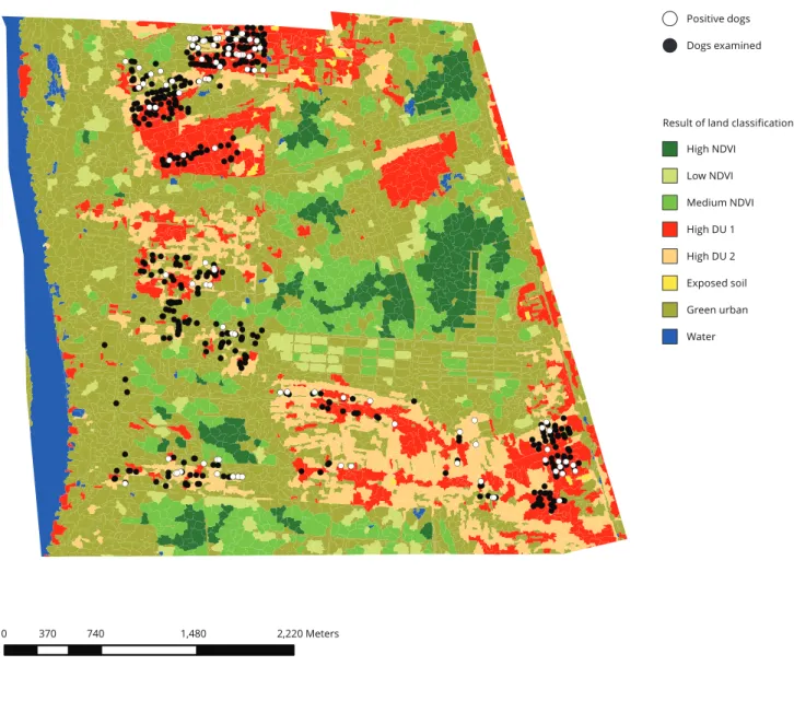
Figure 3 shows the result of the classification of satellite images. In the more urbanized areas, where the households investigated for canine VL are located, the land use and cover characteristics of “High NDVI” and “Low NDVI” are absent, and the characteristics “Medium NDVI” and “Bare soil” are pres-ent in only six and one of the 446 squares evaluated, respectively.
Table 3 shows the association between environmental characteristics and canine Leishmania
infection. The odds of infection were twice as high for households located in squares in which the area covered by residential structures with little vegetation (“High DU 1”) was ≤ 25m2, when
com-pared with those in which such cover reached ≥ 600m2, even after adjusting for head-of-household’s
schooling, presence of animals or animal shelters in the peridomicile, and indicators of environmental
Figure 3
Land use and land cover classes and location of seropositive and seronegative dogs, Angelim neighborhood, Teresina, Piauí State, Brazil, 2007.
and household vulnerability. Analogously, households located in squares with up to half of the area covered by residential structures with extensive vegetation (“High DU 2”) showed 65% lower odds of canine infection when compared to households located in areas almost totally covered by this type of land cover. The “green urban” variable did not show a statistically significant association with the outcome.
Discussion
The study’s results demonstrate that given characteristics of the environment related to land use and land cover are associated with canine infection with Leishmania. In general, human dwellings located in areas with more vegetation cover harbored more seropositive dogs.
This result is consistent with other studies that have pointed to higher canine seropositivity for
Leishmania in dwellings close to forest areas 21,22,23,24,25,26. The proximity to areas with more dense
vegetation favors interaction between the sylvatic and peridomiciliary cycles of the disease and favors conditions for maintenance of sand fly populations 2.
The importance of environmental transformations in the process of urbanization of VL in Brazil has been highlighted by various authors 3,4,27,28, but there are still few studies specifically designed
to evaluate the role of land use and land cover characteristics in the occurrence of VL in the urban environment, and especially studies focusing on the canine population.
In this context, geographic information systems (GIS) and RS are tools that provide a new per-spective on this subject. The development of studies in this field is important, among other reasons to assess the actual potential of these tools in studies on factors related to patterns of occurrence and dissemination of transmissible diseases and definition of priority areas for implementation of control measures 29.
Spatial approaches to study the epidemiology of infectious diseases using GIS and RS to define high-risk areas for transmission have been used for quite some time 30,31, mainly in studies on Table 3
Odds ratios (OR) and 95% conidence intervals (95%CI) for canine infection with Leishmania infantum associated with environmental characteristics of the Angelim neighborhood, Teresina, Piauí State, Brazil, 2007.
Characteristics Crude OR 95%CI Adjusted OR * 95%CI *
High DU 1 (m2)
≤ 25 2.23 1.34-3.73 2.17 1.24-3.80
26-312 0.73 0.29-1.81 0.89 0.36-2.17
313-599 1.49 0.67-3.32 1.42 0.61-3.29
≥ 600 1.00 1.00
High DU 2 (m2)
≤ 25 0.44 0.22-0.86 0.35 0.17-0.72
26-312 0.44 0.11-1.03 0.36 0.14-0.88
313-599 0.56 0.24-1.36 0.53 0.21-1.32
≥ 600 1.00 1.00
Green urban (m2)
≤ 25 0.69 0.38-1.27 0.86 0.45-1.62
26-312 1.12 0.52-2.42 1.28 0.58-2.83
313-599 0.63 0.28-1.39 0.72 0.32-1.63
≥ 600 1.00 1.00
DU: dense urban.
malaria 30,32. However, their use in the study of VL is much more recent and relatively infrequent,
particularly in Brazil, where VL transmission is zoonotic 33.
Consulting the MEDLINE (PubMed) and LILACS databases on 31/Dec/2015, only 12 studies were identified that used RS to assess the relationship between land use and land cover characteristics and spatial distribution of VL in the Brazilian context 16,18,19,29,34,35,36,37,38,39,40,41.
Only two of these studies addressed the association between environmental features extracted from satellite images and canine VL 34,38. An ecological study in 33 municipalities in Bahia State, by
Bavia et al. 38, found an inverse association between vegetation cover and cases of canine VL. In the
study, vegetation cover was assessed by the NDVI, obtained by satellite images from the AVHRR sen-sor, with resolution 64km2. Meanwhile the study by Machado da Silva et al. 37 in Barra de Guaratiba
in the city of Rio de Janeiro found higher serological titers for canine infection with Leishmania in areas with preserved vegetation. In the study, characterization of vegetation cover was obtained by aerial photographs.
In the other ten studies that did not assess canine VL, seven focused on VL incidence in humans and three on the presence of sand flies. Nine of the ten studies used Landsat satellite images with reso-lution of 15 to 30 meters 16,18,19,29,34,35,39,40,41 and only one used IKONOS images with resolution of
1 to 4 meters 36. As for environmental aspects, seven studies evaluated vegetation cover, mainly using
NDVI, and three evaluated land use and land cover characteristics. Six studies on human VL found a direct association between vegetation cover and risk of VL 16,18,19,29,39,40, while only one found an
inverse association 41. In the studies on vectors, two found higher vector density in areas with little
vegetation cover 34,35 and one found a direct relationship between vegetation cover and presence
of vectors 36.
The current study offers a series of new contributions to the study of relations between the environment and VL. First, it is one of the few studies addressing zoonotic canine VL using satellite images, and is the one with the largest sample size. Second, except for a vector study that used IKO-NOS images 36, the current study is the one that used images with the highest resolution (2.5 meters)
in Brazil, which has been identified as an important characteristic to be considered in the study of VL, particularly in the urban setting 29,42. Third, it uses OBIA, which combines spectral information
with texture and context attributes, allowing greater flexibility for evaluating land use and land cover characteristics in the urban environment 16.
Nevertheless, the results presented here should be viewed with caution. For example, information bias may have occurred in relation to the questions asked in the interview. However, since dog owners were unaware of whether their animals were infected, we believe that if an information bias was pres-ent, it was not influenced by diagnosis of canine infection, thus suggesting non-differential error 43.
Likewise, the low sensitivity and specificity of the serological test used here could lead to outcome classification errors, but would also tend not to be differential. The definition of “case” as the existence of at least one positive dog in the household is also a question to be considered when interpreting the results. Based on this criterion, different types of households are included as “cases”, ranging from those with only one positive dog to those with multiple dogs, of which only one or several dogs might be positive. This heterogeneity in the population of “cases” may disguise differences in the strength of association between land use and land cover characteristics and Leishmania infection in relation to the number of dogs in the household. This aspect may be important, since households with only one positive dog may be less relevant for transmission than households with two or more infected dogs.
Contributors
A. B. F. Figueiredo, G. L. Werneck and A. S. Almeida participated in the study conception and design, data analysis and interpretation, and writing and approval of the final version, and takes full respon-sibility for all aspects of the work in terms of its precision and integrity. M. S. P. Cruz and J. P. Silva participated in the data collection, analysis, and interpretation and writing and approval of the final version, and takes full responsibility for all aspects of the work in terms of its precision and integrity.
Acknowledgments
The authors wish to thank the director of the Department of Healthcare Action under the Tere-sina Municipal Health Secretariat at the time the study was conducted for authorizing use of the data. We also wish to thank community health workers Ricardo, Marilene, Marcos, Edson, and Assis for their assistance during the data collection.
References
1. Alvar J, Velez ID, Bern C, Herrero M, Desjeux P, Cano J, et al. Leishmaniasis worldwide and global estimates of its incidence. PLoS One 2012; 7:e35671.
2. Lainson R, Rangel EF. Lutzomyia longipalpis and the eco-epidemiology of American vis-ceral leishmaniasis, with particular reference to Brazil: a review. Mem Inst Oswaldo Cruz 2005; 100:811-27.
3. Werneck GL. Forum: geographic spread and urbanization of visceral leishmaniasis in Bra-zil. Introduction. Cad Saúde Pública 2008; 24:2937-40.
4. Rangel EF, Vilela ML. Lutzomyia longipalpis
(Diptera, Psychodidae, Phlebotominae) and ur-banization of visceral leishmaniasis in Brazil. Cad Saúde Pública 2008; 24:2948-52.
5. Departamento de Vigilância Epidemiológica, Secretaria de Vigilância em Saúde, Ministério da Saúde. Manual de vigilância e controle da leishmaniose visceral. Brasília: Ministério da Saúde; 2006.
6. Romero GA, Boelaert M. Control of visceral leishmaniasis in Latin America: a systematic review. PLoS Negl Trop Dis 2010; 4:e584. 7. Werneck GL, Costa CH, de Carvalho FA, Pires
e Cruz MS, Maguire JH, Castro MC. Effec-tiveness of insecticide spraying and culling of dogs on the incidence of Leishmania infantum
infection in humans: a cluster randomized trial in Teresina, Brazil. PLoS Negl Trop Dis 2014; 8:e3172.
8. Belo VS, Struchiner CJ, Werneck GL, Barbosa DS, de Oliveira RB, Teixeira Neto RG, et al. A systematic review and meta-analysis of the factors associated with Leishmania infantum in-fection in dogs in Brazil. Vet Parasitol 2013; 195:1-13.
9. da Silva JP, Werneck GL, Macedo EC, de Car-valho H, Cruz MS. Factors associated with
Leishmania chagasi infection in domestic dogs from Teresina, State of Piauí, Brazil. Rev Soc Bras Med Trop 2012; 45:480-4.
10. Camara G, Souza RCM, Freitas UM, Garrido J. Spring: integrating remote sensing and GIS by object-oriented data modeling. Comput Grap 1996; 20:395-403.
11. Mather PM. Computer processing of remote-ly-sensed images: an introduction. 3rd Ed.
Chichester: John Wiley & Sons; 2004.
12. Tu T, Su S, Shyu H, Huang PS. Efficient in-tensity-hue-saturation-based image fusion with saturation compensation. Opt Eng 2001; 40:720-8.
13. Comber AJ. Land use or land cover? J Land Use Sci 2008; 3:199-201.
15. Di Gregorio A, Jansen LJM. A new concept for a land cover classification system. The Land 1998; 2:55-65.
16. Almeida AS, Werneck GL, Resendes APC. Classificação orientada a objeto de imagens de sensoriamento remoto em estudos epidemio-lógicos sobre leishmaniose visceral em área urbana. Cad Saúde Pública 2014; 30:1639-53. 17. Harhay MO, Olliaro PL, Costa DL, Costa CH.
Urban parasitology: visceral leishmaniasis in Brazil. Trends Parasitol 2011; 27:403-9. 18. Cerbino Neto J, Werneck GL, Costa CHN.
Factors associated with the incidence of urban visceral leishmaniasis: an ecological study in Teresina, Piauí State, Brazil. Cad Saúde Pública 2009; 25:1543-51.
19. Werneck GL, Costa CHN, Walker AM, David JR, Wand M, Maguire JH. Multilevel model-ling of the incidence of visceral leishmani-asis in Teresina, Brazil. Epidemiol Infect 2007; 135:195-201.
20. Congalton R, Green K. Assessing the accuracy of remotely sensed data: principles and prac-tices. Boca Raton: CRC/Lewis Press; 1999. 21. Rondon FC, Bevilaqua CM, Franke CR, Barros
RS, Oliveira FR, Alcântara AC, et al. Cross-sec-tional serological study of canine Leishmania
infection in Fortaleza, Ceará state, Brazil. Vet Parasitol 2008; 155:24-31.
22. Cabrera MA, Paula AA, Camacho LA, Marzo-chi MC, Xavier SC, Silva AV, et al. Canine vis-ceral leishmaniasis in Barra de Guaratiba, Rio de Janeiro, Brazil: assessment of risk factors. Rev Inst Med Trop São Paulo 2003; 45:79-83. 23. Almeida AB, Faria RP, Pimentel MF, Dahroug
MA, Turbino NC, Sousa VR. Inquérito soroepi-demiológico de leishmaniose canina em áreas endêmicas de Cuiabá, Estado de Mato Gros-so. Rev Soc Bras Med Trop 2009; 42:156-9. 24. Barbosa DS, Rocha AL, Santana AA, Souza C,
Dias RA, Costa-Júnior LM, et al. Soropreva-lência e variáveis epidemiológicas associadas à leishmaniose visceral canina em área endêmica no município de São Luís, Maranhão, Brasil. Ciência Animal Brasileira 2010; 11:653-9. 25. da Costa AP, Costa FB, Soares HS, Ramirez
DG, de Carvalho Araújo A, da Silva Ferreira JI, et al. Environmental factors and ecosystems associated with canine visceral leishmaniasis in Northeastern Brazil. Vector Borne Zoonotic Dis 2015; 15:765-74.
26. Lopes PM, Sorte EC, Gasparetto ND, Oliveira CM, Almeida AB, Sousa VR. Seroprevalence and risk factors associated with visceral leish-maniasis in dogs in Jaciara, State of Mato Gros-so. Rev Soc Bras Med Trop 2014; 47:791-5. 27. Maia-Elkhoury AN, Alves WA, Sousa-Gomes
ML, Sena JM, Luna EA. Visceral leishmaniasis in Brazil: trends and challenges. Cad Saúde Pública 2008; 24:2941-7.
28. Oliveira CD, Morais MH, Machado-Coelho GL. Visceral leishmaniasis in large Brazilian cities: challenges for control. Cad Saúde Públi-ca 2008; 24:2953-8.
29. Almeida AS, Werneck GL. Prediction of high-risk areas for visceral leishmaniasis using so-cioeconomic indicators and remote sensing data. Int J Health Geogr 2014; 13:13.
30. Correia VRM, Carvalho MS, Sabroza PC, Vasconcelos CH. Remote sensing as a tool to survey endemic diseases in Brazil. Cad Saúde Pública 2004; 20:891-904.
31. Hugh-Jones M. Applications of remote sens-ing to the identification of the habitats of para-sites and disease vectors. Parasitol Today 1989; 5:244-51.
32. Machault V, Vignolles C, Borchi F, Vounatsou P, Pages F, Briolant S, et al. The use of remotely sensed environmental data in the study of ma-laria. Geospat Health 2011; 5:151-68.
33. Bhunia GS, Dikhit MR, Kesari S, Sahoo GC, Das P. Role of remote sensing, geographical information system (GIS) and bioinformatics in kala-azar epidemiology. J Biomed Res 2011; 25:373-84.
34. Casaril AE, Monaco NZ, de Oliveira EF, Egu-chi GU, Paranhos Filho AC, Pereira LE, et al. Spatiotemporal analysis of sandfly fauna (Dip-tera: Psychodidae) in an endemic area of vis-ceral leishmaniasis at Pantanal, central South America. Parasit Vectors 2014; 7:364.
35. de Andrade AR, da Silva BA, Cristaldo G, de Andrade SM, Paranhos Filho AC, Ribeiro A, et al. Spatial distribution and environmental factors associated to phlebotomine fauna in a border area of transmission of visceral leish-maniasis in Mato Grosso do Sul, Brazil. Parasit Vectors 2014; 7:260.
36. Oliveira EF, Silva EA, Fernandes CE, Paran-hos Filho AC, Gamarra RM, Ribeiro AA, et al. Biotic factors and occurrence of Lutzomyia longipalpis in endemic area of visceral leish-maniasis, Mato Grosso do Sul, Brazil. Mem Inst Oswaldo Cruz 2012; 107:396-401. 37. Machado da Silva AV, Magalhães MA, Peçanha
Brazil R, Carreira JC. Ecological study and risk mapping of leishmaniasis in an endemic area of Brazil based on a geographical information sys-tems approach. Geospat Health 2011; 6:33-40. 38. Bavia ME, Carneiro DD, Gurgel HC, Madu-reira Filho C, Barbosa MG. Remote sensing and geographic information systems and risk of American visceral leishmaniasis in Bahia, Brazil. Parassitologia 2005; 47:165-9.
39. Thompson RA, Lima JWO, Maguire JH, Braud DH, Scholl DT. Climatic and demographic de-terminants of American visceral leishmaniasis in northeastern Brazil using remote sensing technology for environmental categorization of rain and region influences on leishmaniasis. Am J Trop Med Hyg 2002; 67:648-55.
41. Carneiro D, Bavia ME, Rocha W, Lobão J, Ma-dureira Filho C, Oliveira JB, et al. Identificação de áreas de risco para a leishmaniose visceral americana, através de estudos epidemiológicos e sensoriamento remoto orbital, em Feira de Santana, Bahia, Brasil (2000-2002). Rev Baiana Saúde Pública 2004; 28:19-32.
42. Souza IM, Alves CD, Almeida CM, Pinho CMD. Caracterização socioeconômica do es-paço residencial construído utilizando ima-gens de alta resolução espacial e análise orien-tada a objeto. Geografia 2007; 16:119-42.
43. Szklo M, Javier Nieto F. Epidemiology: beyond the basics. 3rd Ed. Burlington: Jones & Bartlett Learning; 2014.
44. Oliveira CL, Assunção RM, Reis IA, Proietti FA. Spatial distribution of human and canine visceral leishmaniasis in Belo Horizonte, Minas Gerais State, Brazil, 1994-1997. Cad Saúde Pública 2001; 17:1231-9.
Resumo
Este estudo examina a associação entre uso e co-bertura do solo e a ocorrência de leishmaniose visceral (LV) canina. Estudo caso-controle em que casos foram residências com cães soropositivos pa-ra LV canina e controles, as residências com cães soronegativos. Utilizaram-se imagens de sensoria-mento remoto (CBERS: 2/CCD e 2B/HRC) para descrever o uso e cobertura do solo em quadrícu-las de 625m2 na região do estudo. A chance da LV
canina foi duas vezes maior em domicílios loca-lizados em quadrículas com área ≤ 25m2 coberta
por estruturas residenciais com pouca vegetação em comparação com aquelas em que essa cober-tura alcançou ≥ 600m2. Domicílios localizados
em quadrículas com até metade da área coberta por estruturas residenciais com muita vegetação tiveram chances 65% menores de LV canina em comparação com aquelas situadas em áreas quase totalmente cobertas por essa característica. Como a infecção canina costuma preceder a ocorrência de casos humanos, a identificação de característi-cas de uso e cobertura do solo associadas à LV ca-nina pode contribuir para a delimitação de áreas de risco para LV humana.
Leishmaniose Visceral; Cães; Tecnologia de Sensoriamento Remoto
Resumen
Este estudio examina la asociación entre uso y co-bertura del suelo y la ocurrencia de leishmaniosis visceral (LV) canina. Es un estudio de caso-con-trol, donde los casos fueron analizados en resi-dencias con perros seropositivos para LV canina y controles, además de residencias con perros sero-negativos. Se utilizaron imágenes de teledetección (CBERS: 2/CCD e 2B/HRC) para describir el uso y cobertura del suelo en cuadrículas de 625m2 en
la región del estudio. La oportunidad de la LV ca-nina fue dos veces mayor en domicilios localizados en cuadrículas con un área ≤ 25m2, cubierta por
estructuras residenciales con poca vegetación, en comparación con aquellas donde esa cobertura al-canzó ≥ 600m2. Los domicilios localizados en
cua-drículas con hasta la mitad del área cubierta por estructuras residenciales con mucha vegetación tu-vieron oportunidades un 65% menores de LV cani-na, en comparación con aquellas situadas en áreas casi totalmente cubiertas por esa característica. Como la infección canina acostumbra preceder la ocurrencia de casos humanos, la identificación de las características de uso y cobertura del sue-lo, asociadas a la LV canina, puede contribuir a la delimitación de áreas de riesgo para LV humana.
Leishmaniasis Visceral; Perros; Tecnología de Sensores Remotos
Submitted on 31/May/2016