133
Abstract
The main purpose of this study is to compare two methodologies, DRASTIC and GOD, applied to the basin of the Cabril River in determining groundwater vul-nerability to pollution. The justiication for the research work in this area relates to the fact that we are facing a basin adjoining the town of Vila Real (Portugal), with a propensity to expand into this area, and where there are many springs, both near the base of the basin and in hillside areas.
As a result of the application, the GOD and DRASTIC maps were obtained. To better com-pare these inal vulnerability maps, the conversion of the ranges of DRAS-TIC indices to a normal-ized scale from 0.0 to 1.0 value was performed, staying in the same rating scale as the GOD meth-od. It was observed, through the GOD method, that the area of the basin has mostly low or negligi-ble vulnerability, related to the high depth of the groundwater level and also to the low degree of coninement. Moreover, the results of the DRASTIC method indicate that most of the basin pre-sents medium to low vulnerability, especially in areas of higher altitude. However, both methods make high vulnerability correspond to areas covered by alluvium.
It may be concluded from this study that the production of results using different methods of analysis, although with similar objectives, may differ in certain locations. Thus, the outlook for the future is that the vulnerability mapping techniques ought to include physical methods, improving the credibility of these studies.
Keywords: aquifer; vulnerability, DRASTIC, GOD, GIS
Resumo
O principal objetivo desse estudo é a comparação de duas metodologias, DRAS-TIC e GOD, aplicadas à bacia hidrográica do rio Cabril, na determinação da vulne-rabilidade das águas subterrâneas à poluição. A justiicativa do trabalho, nessa região, prende-se ao facto de estarmos perante uma bacia coninante com a cidade de Vila Real (Portugal), com propensão para se expandir para essa área e onde existem muitas nascentes, tanto junto à base da bacia, como nas zonas de meia encosta.
Como resultado da aplicação, obtiveram-se os mapas GOD e DRASTIC. Para melhor comparar esses mapas inais de vulnerabilidade, converteram-se os intervalos dos índices DRASTIC para uma escala normalizada de 0,0 a 1,0 valores, icando em igual escala de classiicação do método GOD. Constatou-se, através do método GOD, que a área da bacia apresenta, na sua maior parte, vulnerabilidade baixa ou desprezível, relacionada com a elevada profundidade do nível de água subterrânea e, também, com o baixo grau de coninamento. Por outro lado, os resultados do méto-do DRASTIC indicam que grande parte da bacia apresenta vulnerabilidade média a baixa, principalmente em zonas de maior altitude. No entanto, ambos os métodos
DRASTIC and GOD
vulnerability maps of the Cabril
River Basin, Portugal
DRASTIC e GOD: mapas de vulnerabilidade da
bacia do rio Cabril, Portugal
Luís Filipe Sanches Fernandes
Dept. of Engineering, University of Trás-os-Montes e Alto Douro e Centre for the Research and Technology of Agro-Environment and Biological Sciences, Vila Real, Portugal
lfilipe@utad.pt
Leila Vanessa Rodrigues Queirós Cardoso
Civil Engineering (MSc) leilavanessa@sapo.pt
Fernando António Leal Pacheco Dept of Geology. University of Trás-os-Montes e Alto Douro and Centre for Chemistry, University of Trás-os-Montes e Alto Douro
fpacheco@utad.pt
Sérgio Leitão
Dept. of Engineering, University of Trás-os-Montes e Alto Douro, 5001-801 Vila Real, Portugal. sleitao@utad.pt
Joao Paulo Moura
Dept. of Engineering, University of Trás-os-Montes e Alto Douro, 5001-801 Vila Real, Portugal and Knowledge Engineering and Decision Support Research Center, Porto, Portugal
jpmoura@utad.pt
Civil Engineering
1. Introduction
apontam para a existência de vulnerabilidade elevadas nas zonas cobertas por aluvi-ões.
O que se pode concluir do presente estudo é que a produção de resultados por métodos de análise distintos, embora com objetivos semelhantes, pode ser diferente em determinados locais. Desta forma o que se pode diagnosticar no futuro é que as técni-cas de mapeamento da vulnerabili-dade deverão contemplar métodos físicos, tornando estes estudos mais credíveis.
Palavras Chave: Aquífero, vulnerabilidade, DRASTIC, GOD, GIS
The world population began to worry about the groundwater resources only about two dec-ades ago. Those who depended on these resources for drink-ing water consumption did nothdrink-ing to maintain the quality of water, much less evaluated the risk of contamination (Foster 1987, Foster et al. 2006). With the introduction of the term “groundwater vulnerability to pollution” numerous def-initions, methodologies and skills about it followed, and it resulted in two indings: intrinsic vulner-ability, which results from the characteristics of the context (aquifer type and coverage, permeabil-ity, depth, recharge, among others), without considering the impact of pollutant sub-stances, and speciic vulnerability that gives superiority to the type and amount of polluting agents (Auge 2004).
There are several methodologies to determine aquifers’ vulnerability to pol-lution. However, the methods used in this study were the DRASTIC and the GOD. The DRASTIC method (Aller et al. 1985) seeks to systematize the determination of the potential of the pollutant to reach the satu-rated zone and, for such, it considers 7 factors: Depth to the water table; Net Recharge; Aquifer material; Soil type; Topography; Impact of the unsaturated zone; and Hydraulic Conductivity. In turn, the GOD method determines the intrinsic vulnerability; hence, it does not consider the type of pollutant. It is based on the designation of indices between 0 and 1 with the variables, Ground water occurrence; Overall aquifer class; and Depth to groundwater table (Foster 1987, Foster et al. 2006). The DRASTIC model has been applied in the study of aquifers’ vulnerability to pollution, and ref-erences may be made to cases such as
the Pampeano aquifer, located north of the province of Bue-nos Aires (Reynoso
et al. 2005), or the Oued Laou aquifer, located in the northeast of Morocco and considered one of the most important in this region (Salhi et al. 2007). This latter aquifer has been threatened by numerous sources of contamination over the past years, and the situation is increas-ingly aggravating, in the absence of any plan of environmental protection. In this context, Salhi et al. (2007) carried out a study on the development of vulnerability maps of the aquifer, which seeks to function as a useful tool for administrators of water resources when making decisions. As for the application of the GOD method in the study of vulnerability to groundwater pollution, reference is made to the work carried out by Barboza et al. (2007) in Ponta de Fruta (Vila Velha, Espírito Santo, Brazil), a region with poor sanita-tion condisanita-tions.
There are cases when different methodologies are applied to a given region, comparing the results. In 2003, Gogu et al. (2003) tested ive methods in assessing the intrinsic vulnerability of a karst aquifer located in the region of Condroz (Belgium). The methods adopted were: EPIK, GOD, “German Method”, ISIS and DRASTIC. After comparing the results, it was concluded that the GOD method, the “German Method” and the ISIS method ascribe more than half of the area under study a high vulnerability. Moreover, DRASTIC and EPIK meth-ods indicate that most of the area under study has moderate vulnerability. Similar research studies have been carried out in other hy-drographical basins, in order to assess the vulnerability of groundwater to pollution caused by an-thropogenic
pres-sures, such as the works by Mendoza and Barmen (2006), which used the DRAS-TIC and GOD methods in the basin of Artiguas River, Nicaragua. Other studies made comparisons between methods of analysis of the aquifers’ vulnerability to pollution, such as the ones by Santos & Pereira (2011) and Tavares et al. (2009) in Brazil; Vías et al (2005) and Martínez-Bastida et al (2010) in Spain; Draoui et al. (2008) in north-eastern Morocco; Roberta et al (1998) in Italy; Ibe et al
(2001) in Nigeria; Pacheco and Sanches Fernandes (2013) in the River Sordo ba-sin, Portugal; etc., being also evaluated, in these cases, the risk of pollution.
Basically, the calculation made by these methodologies, and its mapping, are based on a GIS (Geographical Informa-tion System), as illustrated by the work of Daniela (1999).
The pressing need for a country planning policy based on scientific methodologies and crite-ria has to be effective. The decision support systems, as a tool to assist spatial planning, have re-ceived some attention in the area of aquifers’ vulnerability to pollution, and speciically through the DRASTIC model, as occurred in Hungary (Leone
et al. 2009). Furthermore, in the United States of America, particularly in Colo-rado, the contamination of aquifers with nitrates has been the subject of studies and publications, being used as necessary and effective methodologies to facilitate policy decisions concerning the protection of groundwater (Ceplecha et al. 2004). The present research study its into this same context, its objective being to lay a foundation for the sustainable manage-ment of water resources in the region of Vila Real.
Study area
Cabril River lows from west to east and is located west of the city of Vila Real, in northern Portugal.
It lows into the Corgo River, at the southern end of town (Figure 1), about 1.5 km from the city centre. Cabril
River is about 10.5km long and has a basin area of about 63.8 km2 (Borges
135
between 304 m and 1325 m, with slopesbetween 0 and 106%. It is, therefore, a relatively rugged topography, of the
type of medium altitude mountains. In areas of lower elevation, speciically in the areas surrounding Cabril River
and its tributary streams, the land is little rugged.
Figure 1
Location of the Cabril River hydrographi-cal basin in the municipality of Vila Real.
In the far northeast, the geology of the basin is characterized mainly by metasedimentary units from the Ordovi-cian period (Armorican quartzite). The southeast quadrant is covered by mod-ern alluvium, valley bottom sand-clay deposits, and undifferentiated river ter-races. In the northwest sector, the granite of Lamas de Olo emerges, as well as various units of the Schist-Greywacke Complex (Douro Group, Middle to Up-per Cambrian). Emphasis is also put on
the presence of quartz, aplite, pegmatite and aplite-pegmatite veins, especially in the upper sector of the hydro-graphical basin. The remaining sectors are charac-terized by the emergence of various types of gran-ite. The fracture of the basin is dominated by the following families: i) NNE-SSW to NE-SW and ii) ENE-WSW (Matos 1991). The schist umbric Lithosols and the granite umbric Lithosols are the dominant soil units in the basin under study, as well as soils derived from
ter-races. The hydrograph-ical basin of Cabril River has a moderate extent which is it for agriculture, pastures and forests. Regard-ing the use of the soil, a part of the basin is characterized by intensive irrigation, watered prairie and pinewood. The cli-matic characterization, according to data collected at the udometer stations closest to the basin, shows a rainfall weighted average close to 1236 mm and an average monthly temperature varying between 10ºC and 15ºC.
2. Methodology
DRASTIC Application
Parameter (D) represents the thick-ness of material that a pollutant will have to go through before reaching the
aquifer. That thickness was obtained by measuring the depth of water in wells (Table 1), converting afterwards those
values into vulnerability indices. The number of wells inven-toried is presented in Figure 2(a).
Table 1
The depth of water in wells Wells Depth of
Water (m) Wells
Depth of
Water (m) Wells
Depth of
Water (m) Wells
Depth of Water (m)
1 5.40 9 2.60 17 8.00 25 4.50
2 1.30 10 2.30 18 2.00 26 2.10
3 10.50 11 0.30 19 8.70 27 0.80
4 5.70 12 7.30 20 18.00 28 1.30
5 8.40 13 6.90 21 10.60 29 4.80
6 2.60 14 7.40 22 3.50 30 3.50
7 4.80 15 5.70 23 2.60 31 1.90
8 3.90 16 4.40 24 7.40 32 7.20
33 1.20
They are not evenly distributed, and the absence of wells in considerable land extents north and west of the basin may be observed. These land extents are located in areas where high altitudes
predomi-nate, where there are also high rainfalls, where water withdrawals for irrigation are essen-tially spring-type and not well-type. From the data collected (location of each well and its depth of hydrostatic
Figure 2 Spatial data of Cabril River Basin: wells locations (a), depth of hydrostatic level (b), sub-basins (c), annual recharge of the aquifer (d), material of the aquifer (e), soils (f), topography (g) and hydraulic conductivity (h).
Parameter (R) represents the an-nual recharge of the aquifer. In general, the higher the re-charge, the greater the potential for the contamination of an aquifer. However, a high volume of re-charge also causes dilution of pollutants, reducing their pollution effect. To access parameter R, ahydrological modelling
software called ArcSWAT was used (Winchell et al. 2008). In the context of that modelling, the recharge is calculated at the scale of the sub-basin by a balance of water and it is, therefore, necessary to have information on the daily rainfall over the basin. The two udometer stations with this type of data are located outside the
basin. The range of data adopted in the model-ling encompassed the 1959-1967 period. After outlining the sub-basins map (Figure 2(c)), determin-ing the respec-tive values of annual recharge, and apply-ing the conversion table relatapply-ing to this pa-rameter, the spatial distribution of R was obtained, as illustrated in Figure 2(d).
The material of the aquifer (A) describes the mitigation capacity of the rocky soil (porous, fractured or karstiied), consolidated or not, which serves as an aquifer. In general, the coarser-grained rocks or those with more fractures or
cavities have higher hydraulic conductivity and, there-fore, less mitigation capacity. Moreover, these characteristics of the aquifer material also inluence the path-ways used by pollutants, that is, their hy-drodynamic dispersion. In the case under
137
DRASTIC = Dp×Di + Rp×Ri + Ap×Ai + Sp×Si + Tp×Ti + Ip×Ii + Cp×Ci (1)where, i represents the index assigned to the parameter in question and p the weight assigned to that same parameter.
The weight of each parameter relects its importance relative to the remain-ing pa-rameters. It ranges from 1 to 5
(quantiication of the DRASTIC index to general situations of vul-nerability), resulting in (2):
DRASTIC = 5×Di + 4×Ri + 3×Ai +2×Si + 1×Ti + 5×Ii + 3×Ci (2)
GOD Application
The determination of the GOD vulnerability index involves identifying the degree of con-inement of the aquifer groundwater, quantiied by a value in the range from 0.0 to 1.0, the litholog-ical characterization of the horizon located
above the saturated zone of the aquifer, categorized by a value in the range from 0.4 to 1.0, and, inally, the estimation of the depth of the groundwater table, converted into values in the range from 0.6 to 1.0. The index is the product of the previous
values, that is, GOD = Groundwater oc-currence (G), Overall lithology of aquifer or aquitard (O) and Depth to groundwater table (D) (Foster et al.2006). GOD values are matched with a qualitative scale of vulnerability, as presented in Table 2.
Table 2
GOD values and corresponding classes of vulnerability. Adapted from Vogel (2008).
As there is no speciic information, the degree of coninement of the aquifer in the hydro-graphical basin of Cabril River (parameter G) was established as follows: with no coninement in areas where soil cover is composed of terraces
and alluvium; with semi-coninement or conine-ment in the remaining sec-tors, depending on the density of rocks fracture. In the latter case, the smaller the fracture, the greater the aquifer’s degree of coninement. To determine
pa-rameter G, in a irst stage, two support maps were produced, using ArcGIS: (a) a G1 map, in which only the exist-ence of free aquifers was considered. In this map, the area of terraces and alluvium was represented by the value 1 (free values of the A index was based on the
work by Pacheco et al. (2004), carried out in a basin adjacent to the Cabril River basin (Sordo River Basin). Initially, the lithotypes were distinguished in Terraces / Alluvial and Granite / Paleozoic Metasedi-ments. On the basis of the geological map of the basin, the irst group was assigned the index 6. To the second group, consider-ing the fracture densities calculated on the basis of geological structures marked on the geological chart (0 to 9.36 km/km2),
the indices 2 (class 0 to 8 km/km2 from
Pacheco et al. 2004) and 3 (grade 8-16 km/ km2) were assigned. Once the variation
ranges of index A were estab-lished, the inal map of the parameter illustrated in Figure 2(e) was drawn up.
The soils (parameter S) control the concentrations of pollutants in the water, and hence their adverse effects, through their permeability characteristics and capacity to produce colloidal com-plexes which determine their retention power. According to Pacheco et al. (2004), and based on textural characteristics of soils in the hydrographical basin of Cabril River, a correlation between soil typologies and parameter S was established. The soil units present in the basin are the lithosols (area: 43 km2), sometimes sandy (0.4 km2),
the terrace anthrosols (17.1 km2),
luvi-soils (1.6 km2) and cambisols (1.1 km2).
Conversion into vulnerability indices of parameter S resulted in values of 5, 8, 8, 7 and 7, respectively (Figure 2(f)). Urban areas have been assigned the index 4.
The parameter topography (T) as-sesses the inluence of the relief of the area under study on the fate of pollutants spilled over planet Earth. This parameter sets the probability of a pollutant to low freely or remain at the surface long enough to iniltrate. The hydraulic gradient, the direction of low, and the development of soils are related to the slope. Usually, higher slopes involve greater hydraulic gradients, and naturally higher velocities of groundwater low. On the basis of the Terrain Digital Model of the Cabril River Basin, its slope map was drawn up, using, for that, tools from ArcGIS. After the pro-duction of this map, slopes were converted into indices T, according to the DRASTIC conversion table (Figure 2(g)).
The unsaturated zone (parameter I) is the horizon underlying the soil and above the ground-water table. The type of material that this area is composed of inluences the time of contact of the environment with the pollutant, boost-ing the development of biodegradation, neutralization, me-chanical filtration, chemical reaction, volatilization and
dispersion processes. In the unsaturated zone, fracture is particularly important, since it promotes the vertical percolation of the pollutant to the aquifer. Due to lack of data on the unsaturated zone of the Cabril River Basin, a typical index of 4 was assumed for the entire basin, corresponding to metamorphic/igneous rocks, as the basin is composed mostly of this type of rocks.
The hydraulic conductivity param-eter (C) describes the ease with which the water passes through the pores, cracks, cavities or layering of the aquifer, being conditioned by the quantity, vol-ume and connectivity of the voids in the middle. For the basin under study there are no data on this parameter. For the basin which is con-tiguous of Sordo River, Pacheco and Van der Weijden (2007) determined values of 3.1±2.9x10⁻⁶ m/s (0.27±0.25 m/d), for the
granites and metasediment rocks. These values are much lower than the minimum value of class C = 1, which is 4.6 m/day. For that reason, based on the geological mapping of the area, the following values were assigned: index 2 to alluvium; index 1 to granites and paleozoic metasediments (Figure 2(h)).
In accordance with the model, the DRASTIC vulnerability index was calcu-lated by the ex-pression (1):
0.0 0.1 0.2 0.3 0.4 0.5 0.6 0.7 0.8 0.9 1.0
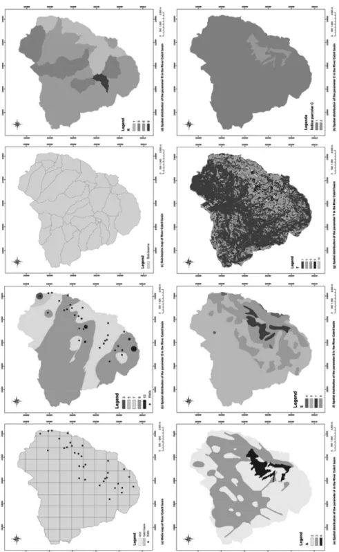
Figure 3 Spatial distributions of GOD method: parameter G (a), parameter O (b) and parameter D.
aquifer) and the remaining areas by the value zero (with the meaning of un-rated); (b) a G2 map, in which the existence of conined aquifers and semi-conined was consid-ered, in line with density of rocks fracture. Three density ranges were arbitrarily considered. The limits of those ranges were deined on
the basis of the frequency of densities, each range represent-ing one third of those frequencies: [< 1.25 km/km2],
[1.25-3.45 km/km2], [ > 3.45 km/km2].
Each range was assigned an index rep-resenting confined or semi-confined aquifers, respectively 0.2, 0.3, and 0.4. To draw the map of parameter G
(Fig-ure 3(a)) at each point of the basin the maximum val-ue of G1 and G2 maps was selected. This option allowed that the zone of terraces and alluvium was invariably identiied by the index 1 and that the remaining areas were identiied by a value between 0.2 and 0.4, depend-ing on the fracture density.
As to parameter (O) (Figure 3(b)), it may be observed that the area of the basin only com-prises two lithological groups: the alluvium and the igneous formations, to which the values 0.7 and
0.6, respectively, correspond.
Finally, parameter D (Figure 3(c)), evaluated through the values of the depth of the ground-water table under the wells inventoried, is represented
by only two ranges: depths below 5 m and depths between 5 and 20 m. The igures for each range are 0.9 and 0.8, respectively.
3. Results and discussion
Regarding the results and mapping of the DRASTIC methodology, and with respect to pa-rameter D (Figure 2(b)), it may be observed that the area of the
ba-sin is occupied mainly by partial indices 7 and 9. These indexes match with the depth ranges between 1.5 m and 4.6, and between 4.6 m and 9.1 m,
139
Figure 4
DRASTIC map for the Cabril River Basin.
The map of parameter G, obtained by applying the GOD methodology to the Cabril River Basin, is presented in Figure 3(a). The most vulnerable areas are the places where the soils are composed of alluvium and terraces, and the aquifer is assumed to be free. At these locations, the value of G is 1. According to the fracture density, the zones of granites and metasediments are as-sumed to be areas of semi-confined to confined aquifers, with values of G ranging between 0.2 and 0.4. The map of parameter O (Figure 3(b)) highlights the alluvium spots, with O = 0.7,
and the spots of igneous formations with O = 0.6. Finally, parameter D (Figure 3(c)) classiies the entire basin as high vulner-ability, dividing it into sectors where D = 0.9 in which the depths of the groundwater table are less than 5 meters, and sectors where D = 0.8 corresponding to the areas where the depth of the groundwater table varies between 5 and 20 meters. It should be remembered that the wells inventoried are poorly distributed, as well as the absence of wells in large areas of higher altitude zones, situations that prevented an accurate assessment of parameter D.
The GOD vulnerability map is pre-sented in Figure 5. It may be observed that only the Neg-ligible, Low and High classes are present in the Cabril River Basin. For the most part, the basin is represented by Low vulnerability (0.1 - 0.3), being also covered by some areas where the vulnera-bility is negligible (0.0 - 0.1). These areas correspond to the locations where the depth of wells is higher (5 to 20m) and also to the sectors where the degree of coninement is low. In turn, areas that include free aquifers present high vulner-ability (0.5 - 0.7).
The lowest values are found in alluvial regions, except for two wells located at the southern end of the basin. Analysing the map of parameter R (Figure 2(d)), it may be observed that most of the area studied presents, for this pa-rameter, the average index of vulnerability. This includes recharge values in the range from 102-178 mm/year, corresponding to the partial index 6. On the other hand, only one of the sub-basins, bounded by the ArcSWAT method, is represented by the partial index 8 (178-254 mm/year). The area corresponding to partial index 1 (< 51 mm/year) is located along the main course of Cabril River. The map of parameter A (Figure 2(e)) relects the choices of vulnerability made concerning the granitic areas, to which to the lowest values of the indices correspond, and concerning the areas of alluvium clas-siied with higher indexes. Also arising
from the basis options, index A values are inluenced by the higher or lower fracture density. The map of parameter S (Figure 2(f)) reveals higher vulnerability indices in low elevation areas of the basin under study, where soil units with consid-erable thickness and free sandy textures very close to the free sandy texture were developed. The zones with less vulner-ability are those of higher elevation, where soils present reduced thick-ness of free sandy textures. For the parameter T map (Figure 2(g)), it was concluded that the areas of greatest vulnerability index are the Cabril Valley and tributary streams, dominated by small slopes. The remaining areas of the basin have indices of reduced vulnerability, much of the basin being classiied with the lowest vulnerability index. Given that a typical index of 4 has been as-signed for the en-tire basin, the map of parameter I shows
no spatial variation. A similar situation may be associated to parameter C, since as a typical index 2 was adopted for the alluvium and an index 1 for the remain-ing area of the basin, relectremain-ing the low hydraulic conductivities estimated for the granites and metasediments.
Figure 5 GOD map for the Cabril river basin.
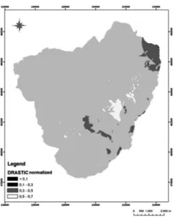
The DRASTIC map was normal-ized to values from 0 to 1 (Figure 6), corresponding to the ranges of vulner-ability of the GOD method, thereby
allowing the direct comparison of the two maps. It is veriied, by applying the GOD method, that the area of the basin presents mostly low vulnerability, and
there is negligible vulnerability related to increased depth of groundwater level and also with low degree of conine-ment.
Figure 6 DRASTIC map normalized for the Cabril
river basin.
The application of the DRASTIC method reveals that most of the basin presents medium vulnerability, and there
is low vulnerability located in an area of higher altitude. Both methods make high vulnerability correspond to areas covered
by alluvium, although by the DRASTIC meth-od those vulnerabilities only cover a small portion of the alluvium.
4. Conclusion
The present study allowed determin-ing which areas of the Cabril River Basin are more vul-nerable to pollution, and therefore, depending on the vulnerability of the area under study, estimat-ing the ac-tivities that may or may not be carried out at the surface, in order to protect ground-water, since we are dealing with an adja-cent site to the capital of the Portuguese
northeast, with a tendency to grow in the area of the basin under study. It should be noted that it is one of the few Portuguese (inner) cities with growth rates. These studies are critical in areas where surface water is scarce; hence, the only reserve wa-ter for use of the resident population is the groundwater, which happens in this basin. The region has been very vulnerable in the
141
5. Acknowledgements
The authors of this study wish to thank University of Trás-os-Montes and Alto Douro, GECAD - Knowledge
Engineering and Decision Support Re-search Center and CITAB (Centre for the Research and Technology of
Agro-Environment and Biological Sciences) for the conditions is provided carrying out this work.
6. References
ALLER, L. et al. DRASTIC: a standardized system for evaluating groundwa-ter pollution poten-tial using hydrogeologic settings.1985. (US, USEPA Report 600/02-85/018).
AUGE, M. Vulnerabilidad de acuíferos, conceptos y métodos. Buenos Aires, 2004. CEPLECHA, Z.L. et al. Vulnerability assessments of Colorado ground water to
nitra-te contamina-tion. Wanitra-ter, Air, and Soil Pollution, 159 p. 373-394, 2004.
DANIELA, D. GIS Techniques for mapping groundwater contamination risk. Natural Hazards, 20s. 279-294, 1999.
BARBOZA, A., ROCHA, S. and GUIMARÃES, D. Estudo preliminar da vulnera-bilidade do aquífero livre localizado na região de Ponta da Fruta, Vila Velha. In: SIMPÓSIO BRASILEIRO DE SENSORIAMENTO REMOTO, 13. Florianópo-lis, Brasil, abril de 2007, INPE, 3279-3286 p.
BORGES, J. Monograia do Concelho de Vila Real. Ser Silito, Maia, 2006.
DRAOUI, M. et al. A comparative study of four vulnerability mapping methods in a detritic aqui-fer under mediterranean climatic conditions. Environmental Geolo-gy, 54 p.455-463, 2008.
ESRI. ArcMap (version 9.3). New York St., Redlands, USA, 2007. 131p.
FOSTER, S. Fundamental concept in aquifer vulnerability pollution risk and protec-tion strategy. Proc. Intl. Conf. Vulnerability of soil and groundwater to polluprotec-tion Nordwijk, The Nether-lands, April 1987.
FOSTER, S. et al.Groundwater quality protection: a guide for water service compa-nies, municipal authorities and environment agencies; s.l. The International Bank for Reconstruc-tion and Development/The World Bank, Servmar – Serviços Técni-cos Ambientais Ltda, Brasil, 2006.
GOGU, R., HALLET, V., DASSARGUES, A.Comparison of aquifer vulnerability assessment techniques. Application to the Néblon river basin (Belgium). Environ-mental Geology, 44, p. 881-892, 2003.
IBE, K., NWANKWOR, G., ONYEKURU, S. Assessment of ground water vulnera-bility and its application to the development of protection strategy for the water supply aquifer in Owerri, southeastern Nigeria. Environmental Monitoring and Assessment, 67 p. 323-360, 2001.
LEONE, A. et al. Vulnerability and risk evaluation of agricultural nitrogen pollution for Hungary main aquifer using DRASTIC and GLEAMS models. Journal of En-vironmental Management, 90. p. 2969-2978, 2009.
MARTINEZ-BASTIDA, J., MERCEDES, A., VALLADOLID, M. Intrinsic and spe-ciic vulnerability of groundwater in central Spain: the risk of nitrate pollution.
Hydrogeology Journal, 18 p. 681-698, 2010.
Matos, A. A geologia da região de Vila Real. Universidade de Trás-os-Montes e Alto Douro, Vila Real, Portugal, 1991.
MENDOZA, J., BARMEN, G. ‘Assessment of groundwater vulnerability in the Río Artiguas basin, Nicaragua’. Environmental Geology, 50 p. 569-580, 2006. PACHECO, F.A.L., SANCHES FERNANDES, L.F. The multivariate statistical
struc-ture of DRASTIC model. Journal of Hydrology, 476 p. 442−459, 2013.
PACHECO, F.A.L., VAN DER WEIJDEN, C.H. Modeling of plagioclase weathering rates in the sordo River Basin (North of Portugal). In: CONGRESSO IBÉRICO DE GEOQUÍMICA, 6 e Semana de Geoquímica, 15. UTAD, Vila Real, 16 a 21 de Julho de 2007, p. 222-225, 2007.
PACHECO, F.A.L. et al. Avaliação da vulnerabilidade à contaminação das águas sub-terrâneas pelo Método DRASTIC na bacia Hidrográica do Rio Sordo, Vila Real. In: Congresso da Água da APRH, 7 Portugal, 2004.
REYNOSO, L. et al. Vulnerabilidad del acuífero Pampeano a la contaminación en el Norte de la Provincia de Buenos Aires. Aplicación de la Metodologia DRASTIC,
Received: 10 April 2012 - Accepted: 27 February 2014.
ROBERTA, A., CORNIELLO, A., DANIELA, D. Aquifer pollution vulnerability in the Roc-camonina Volcano área, southern Italy. Groundwater Quality: Remedia-tion and ProtecRemedia-tion. Proceedings of the GQ'98 Conference held at Tubingen. Ger-many, September 1998, IAHS, nº. 250, 1998.
SALHI, A. et al. Aplicación del método DRASTIC para evaluar la vulnerabilidad a la contamina-ción del acuífero de Oued Laou (Marruecos). Geogaceta, 41, p.191-194, 2007.
SANTOS, M. G. PEREIRA, S. Y. Método AVI (Aquifer Vulnerability Index) para a classii-cação da vulnerabilidade das águas subterrâneas na região de Campos dos Goytacazes, Rio de Janeiro. Engenharia Sanitaria e Ambiental, v.16, n.3, 2011. TAVARES, P. R. L. et al. Mapeamento da vulnerabilidade à contaminação das águas
subterrâneas localizadas na bacia Sedimentar do Araripe, Estado do Ceará, Brasil. REM - Revista Escola de Minas, v.62, n.2, p. 227-236, 2009.
VIAS, J. et al. A comparative study of four schemes for groundwater vulnerability ma-pping in a diffuse low carbonate aquifer under Mediterranean climatic conditions. Environmental Geology, 47 p. 586-595, 2005.
VOGEL, M. Avaliação da vulnerabilidade natural à contaminação dos recursos hí-dricos subterrâneos da Região Cultural da Quarta Colónia de Emigração Italiana. Dissertação, Universidade Federal de Santa Maria, Brasil, 2008.