Marco Chichì
Licenciado em Ciências de Engenharia Civil
Sustainable Urban Planning:
parameters to the operational process
Dissertação para obtenção do Grau de Mestre em Engenheria Civil – Perfil construção
Orientador: Miguel Pires Amado, Professor Auxiliar com
Agregação da Faculdade de Ciências e
Tecnologia da Universidade Nova de Lisboa
Júri:
Presidente: Prof. Doutor Nuno Manuel da Costa Guerra
Arguente: Prof. Doutor João António Muralha Ribeiro Farinha Vogal: Prof. Doutor Miguel José das Neves Pires Amado
Março de 2015
Marco Chichì
Licenciado em Ciências de Engenharia Civil
Sustainable Urban Planning:
parameters to the operational process
Dissertação para obtenção do Grau de Mestre em Engenheria Civil – Perfil construçao
Orientador: Miguel Pires Amado, Professor Auxiliar com
Agregação da Faculdade de Ciências e
Tecnologia da Universidade Nova de Lisboa
Júri:
Presidente: Prof. Doutor Nuno Manuel da Costa Guerra
Arguente: Prof. Doutor João António Muralha Ribeiro Farinha Vogal: Prof. Doutor Miguel José das Neves Pires Amado
“Copyright” Marco Chichi’ , FCT/UNL e UNL
A Faculdade de Ciências e Tecnologia e a Universidade Nova de Lisboa têm o direito, perpétuo e sem limites geográficos, de arquivar e publicar esta dissertação através de exemplares impressos reproduzidos em papel ou de forma digital, ou por qualquer outro meio conhecido ou que venha a ser inventado, e de a divulgar através de repositórios científicos e de admitir a sua cópia e distribuição com objectivos educacionais ou de investigação, não comerciais, desde que seja dado crédito ao autor e editor.
To Professor Miguel Amado, for guidance and availability throughout the execution of this graduation thesis.
To Professor Rodrigo Gonçalves for the help during my stay in Portugal.
To my parents, the love, the affection, patience friendship demonstrated throughout my life especially in phase more difficult and to be the most important people in my life and show me daily that I will always have your unconditional support. Thanks for support and bear me so much every times.
To my brother and my sister for the constant help and support during my study life. To my girlfriend Sonia for the affection and support during my life here in Portugal.
To my remaining family, especially to my uncles, for supporting me at all times and make always my return home a special day.
To my best friends, especially to Manuel and Joao, for all the friendship demonstrated over this years and continue to be part of my day-to-day.
To my best friends Michele, Chiara and Silvia for the affection and unconditional support.
To my best friends Matteo, Emanuele, Gianluca, Claudio and Alfredo for being everyday a support for me indeed we are so far.
To my friends, colleagues, course mates and professors of the NOVA university for sharing with me moments of my academic life.
I In modern society, energy consumption and respect for the environment have become essential aspects of urban planning. The rising demand for alternative sources of energy, coupled with the decline in the construction sector and material usage, gives the idea that the thinking on modern cities, where attention is given to reduced energy consumption, savings, waste recycling and respect for the surrounding environment, is being put into practice.
If we examine development of the city over recent centuries, by means of the theories of the most famous and influential urban planners, it is possible to identify the major problems caused by this type of planning.
For this reason, in recent urban planning the use of systems of indicators that evaluate and certify land environmentally and energetically guides the master plan toward a more efficient city model. In addition the indicators are targeted on key factors determined by the commissioner or the opportunities the territory itself provides.
Due the complexity of the environmental mechanics, the process of design and urban planning has become a challenging issue. The introduction of the indicators system has made it possible to register the life of the process, with a spiral route that allows the design itself to be refined.
The aim of this study, built around the creation of a system of urban sustainability indicators that will evaluate highly eco-friendly cities, is to develop a certification system for cities or portions of them. The system will be upgradeable and objective, will employ real data and will be concerned with energy production and consumption.
Key words: Sustainable Development, Smart City, Assessment and Certification Systems, Sustainable Indicators, Urban Planning
III Na sociedade moderna, o consumo de energia e o respeito pelo meio ambiente são aspectos essenciais a ter em consideração na área do planeamento urbano. A procura crescente de fontes alternativas de energia paralelamente à diminuição do sector de atividade da construção e utilização de materiais, pode dar a ideia de que estamos a seguir o caminho traçado pela escola de pensamento das cidades modernas, onde o ênfase está na redução do consumo de energia, no uso eficiente de recursos, na reciclagem de resíduos e no respeito ao meio ambiente circundante.
Analisando o desenvolvimento da cidade nos últimos séculos, através das teorias dos mais famosos e influentes urbanistas, é possível identificar alguns dos principais problemas causados por esse tipo de planeamento.
Por esta razão, no urbanismo “contemporâneo” o uso de sistemas de indicadores, que avaliam e certificam um local em termos ambientais e energéticos, orienta o plano mestre para um modelo mais eficiente de cidade. Além disso os indicadores são direcionados sobre factores-chave, seguindo a exigência do cliente ou as oportunidades dadas pelo próprio território.
Devido à complexidade dos mecanismos ambientais, o processo de concepção e planeamento urbano tornou-se uma questão desafiante. A introdução do sistema de indicadores permite registrar a vida do processo, com um percurso em espiral conduzindo ao seu aperfeiçoamento.
O objetivo deste estudo pretende a criação de um sistema de indicadores de sustentabilidade urbana que avalie as cidades altamente eco-friendly, após o que será desenvolvido de um sistema de certificação para as cidades, ou partes delas, cujas principais características serão a capacidade de ser atualizável, objetiva, usar dados reais e ter em consideração a produção e consumo de energia.
Termos chave: Desenvolvimento Sustentável, Smart City, Aavaliação e Certificação de Sistemas, Indicadores Sustentáveis, Planeamento Urbano
V ABSTRACT ... I CONTENTS ... V CONTENTS OF FIGURES...IX CONTENTS OF TABLES...XI LIST OF ABBREVIATIONS...XIII PART 1: INTRODUCTION ... 1 1.01 THESIS THEME...1 1.02 OBJECTIVE...1
1.03 STRUCTURE AND METODOLOGY...2
PART 2: STATE OF THE ART ... 5
2.01 INTRODUCTION TO PART 2...5
2.02 DEFINITION OF CITY...5
2.03 THE CITY IN EUROPE...8
2.04 THE EUROPEAN MODEL CITY...9
2.05 CERDÀ AND THE ORIGIN OF URBAN PLANNING...10
2.06 OLMSTED AND THE AMERICAN MODEL...13
2.07 LA CIUDAD LINEAL: ARTURO SORIA Y MATA...15
2.08 HOWARD AND THE GREEN BELT...16
2.09 LA CITÉ INDUSTRIELLE OF TONY GARNIER...19
2.10 LE CORBUSIER AND THE FUTURE VISION...21
2.11 CLARENCE STEIN AND THE AMERICAN GARDEN CIY...22
2.12 THE MODEL OF WRIGHT...24
2.13 SPRAWL CITIES ...26
2.14 GLOBAL CITY...29
2.15 SHRINKING CITIES...32
2.16 SMART CITIES ...36
2.17 DEFINITION OF SUSTAINABLE DEVELOPMENT...38
2.18 AGENDA 21...40
2.19 AALBORG CHARTER...42
2.20 THE KYOTO PROTOCOL ...44
2.21 LISBON AND GÖTEBORG STRATEGIES ...46
2.22 EU 2020 STRATEGIES ...47
2.23 20/20/20 EUROPEAN STRATEGIES...49
VI PART 3: THE IMPORTANCE OF INDICATORS FOR THE SUSTAINABLE URBAN
PLANNNING ... .55
3.01 INTRODUCTION TO PART 3...55
3.02 SUSTAINABLE INDICATORS...55
3.03 WHAT ARE THE INDICATORS OF SUSTAINABILITY ...57
3.04 THE CORE SET OF INDICATORS...58
3.05 LEED RANKING SYSTEM ...63
3.06 THE PORTUGUESE SYSTEM "LIDERA"...65
3.07 THE IUSIL SYSTEM ...67
3.08 THE STAR COMMUNITY RATING SYSTEM ...68
3.09 THE GLOBAL CITY INDICATORS: ISO 37120:2014 ...69
3.10 BENCHMARKING OF THE SYSTEMS...70
3.11 WORLDWIDE PRACTICES WITH INDICATORS ...71
3.11.1.SINGAPORE... 71
3.11.2 OEIRAS E-CITY ... 71
3.11.3 COPENHAGEN ... 72
3.11.4 MEXICO CITY ... 73
3.12 CONCLUSIONS ...73
PART 4: SYSTEM OF SUSTAINABLE URBAN PLANNING ... 75
4.01 INTRODUCTION TO PART 4...75
4.02 THE NEED FOR A SYSTEM OF SUSTAINABLE URBAN PLANNING...75
4.03 GUIDELINE FOR THE SUGGESTION...75
4.04 BASED CONCEPTS...76
4.05 METEDOLOGY OF THE PURPOSE SYSTEM...77
4.06 SYSTEM OPERATION ………...79 4.07 ENVIROMENT ...81 4.07.1 ENVIROMENTAL HEALTH ... 81 4.07.2 ECOSYSTEM VITALITY ... 83 4.07.3 ECONOMIC SUSTAINABILITY ... 84 4.07.4 URBAN MORPHOLOGY ... 84 4.08 SOCIAL ...85 4.08.1 SMART SERVICES ... 86 4.08.2 SOCIAL EQUITY ... 88 4.09 ECONOMY ...89
VII
4.10.1 SUSTAINABLE MANAGEMENT ... 91
4.11 STRUCTURE OF "SSUP"………...92
4.12 HOW THE "SSUP" WORKS...93
4.13 THE MONITORING SYSTEM...94
4.14 DISCUSSION OF THE SYSTEM...96
PART 5: CONCLUSIONS ... 97
5.01 CONCLUSIONS...97
5.02 FUTURE DEVELOPMENT...98
BIBLIOGRAPHY ... 99
IX
Fig 2.1 UN Population Division (2011)...6
Fig 2.2 Level of urbanization in EU ...8
Fig 2.3 Cerdà blocks design...12
Fig 2.4 Cerdà master plan for Barcelona...13
Fig 2.5 Emerald Necklace...14
Fig 2.6 Ciudad Lineal...15
Fig 2.7 Howard Green Belt plan...18
Fig 2.8 Citè industrielle...21
Fig 2.9 Radiant City...22
Fig 2.10 Radburn plan...24
Fig 2.11 Bodoacre City...25
Fig 2.12 Sprawl in Los Angeles...29
Fig 2.13 Global Cities Index...30
Fig 2.14 Example of shrinking in Detroit...35
Fig 2.15 Smart City Circle...36
Fig 2.16 Key concept of sustainable urban development...39
Fig 2.17 UN Environment Programme ratings from Rio 1992...41
Fig 2.18 Kyoto Protocol countries ratification at 2005...45
Fig 2.18 Kyoto Protocol countries ratification at 2005...45
Fig 2.19 Europe 20/20/20 objectives...50
Fig 2.20 IEA prevision to 2050...51
Fig 2.21 EU Smart Grid...54
Fig 3.1 PSR functions...56
Fig 3.2 OECD measurement frameworks...59
Fig 3.3 LEED categories...63
Fig 3.4 LEED-ND indicators rank...65
Fig 3.5 LIDERA system...66
Fig 3.6 Distribution of the total co2 reduction, 2005 – 2015...72
Fig 4.1 Methodological scheme of the system...76
Fig 4.2 Macro Area Ponderation...77
Fig 4.3 Sections Ponderation ...78
Fig 4.4 Example form...90
Fig 4.5 Certification Scores ...92
XI CONTENTS OF TABLES
Table 2.1 UN World Urbanization Prospects The 2009 Revision Population
Database...7
Table 2.2 SET-Plan (2007)...53
Table 3.1 IUSIL indicators...67
Table 3.2 Star Certification System (STAR 2014)...68
Table 3.4 Benchmarking of systems...70
Table 3.5 E-City indicators...71
Table 4.1 Indicator division...78
Table 4.2 Environmental Health Indicators...80
Table 4.3 Ecosystem Vitality Indicators...81
Table 4.4 Economic Sustainability Indicators...82
Table 4.5 Urban Morphology ...83
Table 4.6 Smart Services Indicators...84
Table 4.7 Social Equity Indicators...87
Table 4.8 Sustainable Society Indicators...88
Table 4.9 Sustainable Management Indicators...89
Table 4.10 SSUP Working System...91
XIII SSUP: System of Sustainable Urban Planning
UN: United Nations
WHO: World Health Organization EU: Europe Union
USA: United States of America
USSR: The Union of Soviet Socialist Republics
RPAA: Association study of American regional planning CHC: City Housing Corporation
ICT: Information and Communication Technologies CO₂: Carbon dioxide
WCED: World Commission on Environment and Development UNEP: United Nations Environment Programme
ECO-SOC: UN Economic and Social Council ECCO: European Climate Change Programme JI: Joint Implementation
CDM: Clean Development Mechanism GDP: Gross Domestic Product
R&D: Research and Development EIB: European Investment Bank
EU-ETS: European Union Emission Trading Scheme BAU: Business as usual
SET-Plan: European Strategic Energy Technology Plan DER: Distributed Energy Resources
P2P: Peer to Peer
OECD: Organization for Economic Co-operation and Development IS: Indicators of Sustainability
G7: Group of Seven (France, Germany, Japan, Italy, United Kingdom, United States and Canada) PSR: Pressures -State- Response
UN – CSD: United Nations Council on Sustainable Development DSR: Driving Forces -State- Responses
EEA: European Environmental Agency
DPSIR: Driving Forces - Pressures -State- State- Impacts – Responses ESI: Environmental Sustainability Index
EPI: Environmental Performance Index
UNCHS: United Nations Centre for Human Settlements CSD: Commission on Sustainable Development
1 PART 1: INTRODUCTION
1.01 THESIS THEME
The theory of sustainability has developed rapidly and it is well known in the academic world. Its course of about 30 years has enabled us to deepen many theories, to explore topics poorly known until now and in opposition to the economic theories emerged in the past (Capitalism and Marxism) who saw the earth as a source of space and resources always available in the same way .
Since 1972 (Stockholm - Sweden, the United Nations Conference on the Human Environment) has begun to talk about the environment with its ability to provide resources (carrying capacity) and to absorb or not the waste from the processing of these data. The new approach to a different kind of development starts from the fact that there are constraints and biophysical limits, natural resources, absorption of pollution, demographic and carrying capacity.
The goal is to grow by meeting the needs of the present without compromising the ability of future generations to satisfy their own, through the protection of environmental resources (environmental dimension), economic growth through investment (economic dimension) and social and cultural equity (social dimension).
Most urban areas in Europe are facing a number of common issues related, not only to their physical expansion and population growth, but also to the environment and society. The noise and air pollution, the phenomenon of urban sprawl, the production of clean energy, the decarbonisation, well as social exclusion and road safety are all issues that arise in the way of a more sustainable urban development.
The imperative of sustainability has also led the European Union and other international organizations to identify and develop appropriate indicators to monitor progress towards sustainable growth. The spread of indicators, methods and models are in fact essential to support decision making in environmental matters and the last decade has developed considerable action in this regard.
1.02 OBJECTIVE
The main objective of this work is the study, development and proposal of a set of parameters that allow the creation of a simplified indicator model applicable to urban planning processes, which lead to the construction of new sustainable cities or modification of existing cities.
This work aims to define the concepts and principles of urban development in Europe and the International norms promoting to greater awareness of the importance of the evaluation of urban settlements in terms of performance and sustainability.
With the proposal of the evaluation system "SSUP", applied to the European context, this work achieves its goals, which are reflected in the presentation of a system of evaluation and certification of sustainable
2 urban planning. This includes the most important and relevant indicators in terms of sustainability in a simple, equitable and easy to implement in order to have a wide spread.
1.03 STRUCTURE AND METHODOLOGY
The presented thesis is divided into five chapters, the first, this introductory chapter, presents the framework to the theme, the objectives of the thesis and its organization and methodology.
The second chapter is the theoretical basis of all the work, it defines the concepts and principles of European city, describing the evolution of the concept of planning over the years. The urban typologies that have developed through the theories of famous urban planners are analysed later in this chapter. This study aims to describe the structure, evaluation criteria and regulations that have been implemented over the years. The chapter has several subchapters dedicated to fundamental events in defining the theory of urban sustainability.
The third chapter presents the meaning and the theory of the sustainability indicators. There are several subsections that describe the most popular systems used, explaining the diversities.
In the fourth chapter it is proposed the evaluation system "SSUP". Through four different Macro Areas, several categories, parameters of sustainability, their goals and individual evaluation are described. The weightings of each of the parameters defined and all the criteria, according to the degree of importance in terms of sustainability, are determined.
In the fifth and final chapter, the final conclusions on all the thesis are exposed and some suggestions are given for the future development of the system.
The completion of this thesis has been achieved through an intense collection of bibliographic information, which includes international and national publications of articles, several consulting works, researches carried out on various topics and official websites of institutions involved in certification systems.
3 Fig 1.1: Study Methodology
5 PART 2: STATE OF THE ART
2.1 INTRODUCTION TO PART 2
The second part presents an analysis of the “state of the art” with the objective of acquiring and consolidating general knowledge on the subject. It describes basic concepts of city, its history and development. The use of different point of view of famous planners helps to understand the deeper analysis of the city planning used in this dissertation. All the steps associated with the study of sustainable development are described later. Also there is a deep analysis of the EU and World meetings that promotes different solutions of the urban planning. In the last step is explicated the theory that EU intends to use to promote its idea of sustainable development for cities.
2.2 DEFINITION OF CITY
Countries and cultures defines cities in different ways, the only terms that they have in common is that a city is the concept to be “a large town”1. The city is a stable and large human settlement, an urban area that differs from one country or a village in size, population density, importance, or legal status. Generally, a city is made up of residential, commercial, industrial and administrative areas that may also be of interest to a wider geographical area.
The city now days is considered the excellent artificial ecosystem where is possible face all the problems of the climatic changes and the urgency of the effects caused by years of excessive consumption of resources, that led the city to have to find appropriate instruments for have the least possible impact on the territory. The city is defined by Landry (2006) as a living organism that consumes food, water, energy and produces waste. This system needs to feed and regenerate glass, plastic, concrete, brick.
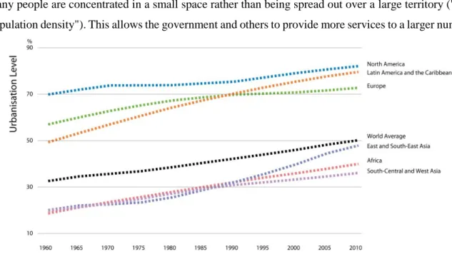
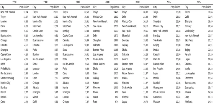
Directly related to the concept of city there is the urbanization. This is the process of growing of a city, it is measured by the percentage change in a city's population from year to year (Fig 2.1). Following industrialisation, large numbers of people moved to cities in search of jobs, mostly in factories, and since then there has been an unprecedented growth in the number and size of cities worldwide (Table 2.1). The international community must devote more attention to cities.
The report of UN, State of the World's Cities 2010/2011: Bridging the Urban Divide (2011), stimulates city planners to improve access to affordable housing and land, increase public services and quality of life. The main problem isn’t the city itself, but the management and the development of cities.
6 The advantage of a city is that it has a greater population density than rural areas, which means that many people are concentrated in a small space rather than being spread out over a large territory ("low population density"). This allows the government and others to provide more services to a larger number
Fig. 2.1: UN Population Division (2011). World Urbanization Prospects: The 2009 Revision Population Database. (esa.un.org/unpd/wup/index.htm)
of people. One electricity line to a single neighbourhood can serve hundreds or thousands of people. Of course, this requires highly complex planning and money, which is collected through taxes. Not all citizens have equal access to what their city offers. In some areas of every city there are people without homes, without electricity and without water.
The three fundamental aspects of the growing of a city can be resumed in: "economic growth", "natural increase" and "rural-urban migration". There are exceptions to this general rule. Some cities, for example, are "created" by governments that want to take the burden off the large cities. Sometimes, such cities are made the capitals of the country, as in the case of Brasilia in Brazil, or new cities to regulate the migration from the countryside like the “ghost city” of Huanshan in the East part of China.
Urbanization can be the best solution for the future but it doesn’t solve alone all the problems. It may be the only way to deal with the massive population increase. The problem is not that cities are bad, the problem is that, with more and more people relying on the city's services and infrastructure, governments, planners and the society have to change their approach to a more smart and sustainable strategy of development.
7 For this reason The World Health Organization (WHO) sets some criteria for the good planning of the city; a healthy city must have:
a CLEAN and SAFE environment
meets the BASIC NEEDS of ALL its inhabitants
involves the COMMUNITY in local government
provides easily accessible HEALTH services
The United Nations Development Programme (UNDP) has outlined these priorities as part of its urban strategy:
increasing SHELTER for the urban poor
provision of basic urban services such as EDUCATION, primary HEALTH CARE, CLEAN WATER AND SANITATION
improving women's access to BASIC SERVICES and government facilities
upgrading ENERGY use and alternative TRANSPORT systems
reducing air POLLUTION
Table 2.1: UN World Urbanization Prospects The 2009 Revision Population Database. (esa.un.org/unpd/wup/index.htm)2
2 Population expressed in millions
City Population City Population City Population City Population City Population City Population City Population New York-Newark 12,34 Tokyo 28,55 Tokyo 32,53 Tokyo 34,45 Tokyo 36,93 Tokyo 38,20 Tokyo 38,66
Tokyo 11,27 New York-Newark 15,60 New York-Newark 16,09 Mexico City 18,02 Delhi 21,94 Delhi 25,63 Delhi 32,94
London 8,36 Mexico City 13,01 Mexico City 15,31 New York-Newark 17,85 Mexico City 20,14 Shanghai 22,96 Shanghai 28,40
Paris 6,28 São Paulo 12,09 São Paulo 14,78 São Paulo 17,10 New York-Newark 20,10 Mexico City 21,71 Bombay 26,56
Moscow 5,36 Osaka-Kobe 9,99 Bombay 12,44 Bombay 16,37 São Paulo 19,65 New York-Newark 21,33 Mexico City 24,58
Buenos Aires 5,10 Los Angeles 9,51 Osaka-Kobe 11,04 Delhi 15,73 Shanghai 19,55 Bombay 21,21 New York-Newark 23,57
Chicago 5,00 Buenos Aires 9,42 Calcutta 10,89 Shanghai 13,96 Bombay 19,42 São Paulo 21,03 São Paulo 23,17
Calcutta 4,51 Calcutta 9,03 Los Angeles 10,88 Calcutta 13,06 Beijing 15,00 Beijing 18,08 Dhaka 22,91
Shanghai 4,30 Paris 8,67 Seoul 10,54 Buenos Aires 11,85 Dhaka 14,93 Dhaka 17,38 Beijing 22,63
Osaka-Kobe 4,15 Bombay 8,66 Buenos Aires 10,51 Los Angeles 11,81 Calcutta 14,28 Karachi 15,50 Karachi 20,19
Los Angeles 4,05 Rio de Janeiro 8,58 Delhi 9,73 Osaka-Kobe 11,17 Karachi 13,50 Calcutta 15,08 Lagos 18,86
Berlin 3,34 Seoul 8,26 Rio de Janeiro 9,59 Rio de Janeiro 10,80 Buenos Aires 13,37 Buenos Aires 14,15 Calcutta 18,71
Philadelphia 3,13 Moscow 8,14 Paris 9,33 Dhaka 10,28 Los Angeles 13,22 Los Angeles 14,08 Manila 16,28
Rio de Janeiro 2,95 London 7,66 Cairo 9,06 Cairo 10,17 Rio de Janeiro 11,87 Lagos 13,12 Los Angeles 15,69
Saint Petersburg 2,90 Cairo 7,35 Moscow 8,99 Beijing 10,16 Manila 11,65 Manila 12,86 Shenzhen 15,54
Mexico City 2,88 Chicago 7,22 Jakarta 8,18 Karachi 10,03 Moscow 11,47 Istanbul 12,46 Buenos Aires 15,52
Bombay 2,86 Jakarta 5,98 Manila 7,97 Moscow 10,00 Osaka-Kobe 11,43 Guangzhou 12,39 Guangzhou 15,47
Detroit 2,77 Shanghai 5,97 Shanghai 7,82 Manila 9,96 Cairo 11,03 Rio de Janeiro 12,38 Istanbul 14,90
Boston 2,55 Manila 5,95 London 7,65 Seoul 9,92 Istanbul 10,95 Shenzhen 12,34 Cairo 14,74
Cairo 2,49 Delhi 5,56 Chicago 7,37 Paris 9,74 Lagos 10,79 Moscow 12,14 Kinshasa 14,54
2025
2000 2010 2015
8 2.03 THE CITY IN EUROPE
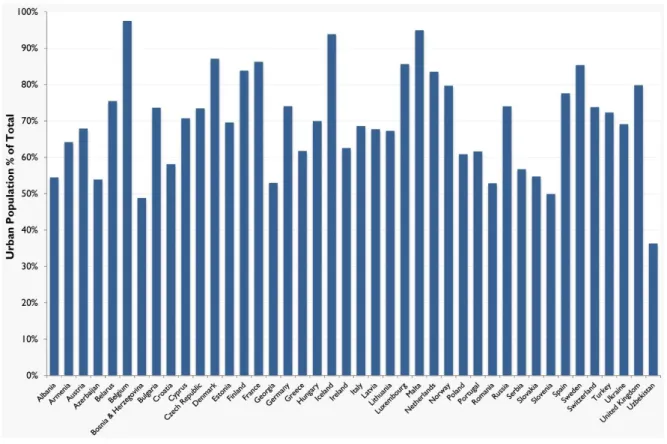
Europe is one of the most urbanised continents in the world. More than two thirds of the European population lives in urban areas and this share continues to grow. Europe, in the last century, develop from a rural to a predominantly urban continent. . It is estimated that around 70 % of the EU population – approximately 350 million people – live in urban agglomerations of more than 5 000 inhabitants. Europe is also characterised by a more polycentric and less concentrated urban structure compared to, for instance, the USA or China (Fig. 2.2).
There are 23 cities of more than 1 million inhabitants and 345 cities of more than 100 000 inhabitants in the European Union, representing around 143 million people. Only 7 % of the EU population live in cities of over 5 million inhabitants compared to 25 % in the USA. In addition, 56 % of the European urban population – around 38 % of the total European population – live in small and medium-sized cities and towns of between 5 000 and 100 000 inhabitants.
Fig. 2.2: Level of urbanization in EU (http://www.hofinet.org)
During the Informal Ministerial Meeting on Urban Development and Territorial Cohesion in Leipzig on 24/25 May 2007 the future of the European city were discussed.
“Our cities possess unique cultural and architectural qualities, strong forces of social inclusion and exceptional possibilities for economic development. They are centres of knowledge and sources of growth and innovation. At the same time, however, they suffer from demographic problems, social
9 inequality, social exclusion of specific population groups, a lack of affordable and suitable housing, and environmental problems.” (Leipzig Charter on Sustainable European Cities, 2007)
The development of cities will determine the future economic, social and territorial development of the European Union. Cities play a key role in the lives because it also plays a key role in the social and economic development of all European territories as engines of the economy, as places of connectivity, creativity and innovation, and as centres of services for their surrounding areas. Nowadays European Commission is promoting different plans to create a model of sustainable urban development. The reason of the creation of this plan is due different causes like the demographic change, stagnation or decline of the economy, employment and social regress, disparity between social classes.
The fundamental core of Europe is its small and medium-sized cities. A large part of the urban population live in small or medium-sized cities spread across the continent. They are centres for public and private services, as well as for local and regional knowledge production, innovation and infrastructure. Small and medium-sized cities often play a pivotal role within regional economies. They constitute the building blocks of urban regions and lend character and distinctiveness to their regional landscapes. The generic features of small and medium-sized cities, particularly their human scale, are liveability, the conviviality of their neighbourhoods, and their geographical embeddedness and historical character – in many ways constitute an ideal of sustainable urbanism (Farr, 2008). Small and medium-sized cities are, therefore, essential for avoiding rural depopulation and urban drift, and they are indispensable for the balanced regional development, cohesion and sustainability of the European territory.
2.04 THE EUROPEAN MODEL CITY
European cities have developed their urban structure in the vicinity of large rivers for defensive reasons and trade, so the urbanization is a result of the industrial revolution and the development of economic activities. The urban structure results very various depending on the origin of the main cities like Athens, Rome, Venice, Paris and Amsterdam. The European city has a distinct morphological dimension: it is characterized by its compact and densely structure built around a central area (old town) where focus public buildings, churches, monuments, areas for trade and exchanges. From this centre, the city extends along the radial lines, articulated in the streets and squares.
Until the early twentieth century European cities remain thickened around their centre and organized on a relatively limited space. This common matrix creates then, in more recent times, different forms that stretch over time according to the choices of technologies for public and private transport, but also because of the action of the state authority that, in any country, let the urban form its national footprint, visible in the style of public buildings, in setting the urban planning and housing policies.
10 Despite this diversification, for the great majority of urban European city in terms of the structuring of the old town, it remains a powerful common meaning. Another characteristic is its longevity. In the vast majority, European cities have very ancient origins: 30% of European settlements are of Roman origin, a portion equally important has its origins in the early Middle Ages where the dispersion in the territory of monasteries and castles formed new urban centres.
One more dimension has its origins in the typical equipment of the production system of the campaign: mills, collection centres and trade markets in pre-industrial times. This means that European cities have a unique temporal continuity, which has led them to accumulate over time, buildings and institutions that make up very significant assets.
Additional elements that characterizes the European city are being part of a very dense urban system and the high incidence of small and medium- size cities. The current structure of the European urban system is bound, for one hand, on the dynamics of the process of urbanization that has led to an acceleration in the last two centuries of unprecedented urban growth, and, on the other hand, it is influenced by the existing urban structure that dates back to the Middle Ages and in large part on which urban growth is in a sense "engaged.”
2.05 CERDÀ AND THE ORIGIN OF URBAN PLANNING
Cerdà3 devoted his entire life to the study of a discipline, that no one before had ever deeper, that he called Urbanism. This name comes from the suffix Urbs (Rome in Latin), and contraction of Urbum which means plow, instrument with which the Romans use to limit the founding the area by constructing a groove, demonstrating that that land was urbanized.
Cerdà understood that cities are incomplete due to lack of sufficient resources, their forms restrictive and suffocating and they could no longer meet the needs of modern civilization. Thus began his research, doing a study to know the needs of agglomerations and acquiring in this way, the knowledge needed to formulate the basic principles of modern urban planning (1867), which he divided into four phases:
1 - Data Analysis and geography of the place.
2 - Define a program of needs and functions according to a rational classification.
1 - Analysis of the fundamental choices.
2 - Morphological expression of these choices.
Cerdà sought the origin of urbanism in the history of primitive man as the necessity to possess a refuge. The immense variety of homes that he studied, showed that the man has always looked for new ways to meet his needs, he deduced, then, that civilization and urbanization go hand in hand. Scientifically he
11 defined urbanization as the totality of the repair (building blocks), the reciprocity of benefits among the inhabitants (purpose), and the ways in common use (middle) and that could be divided into three phases: Troglodyte, the Cyclops and Hovel, and which can be distinguished in them, the more types of tribe whose members lived in huts among different them, isolated and enclosed by a wall.
He found that initially these shelters were not related and that only later the family felt the need to interact building, it was then that they decided to leave around each property a path of common use; the result was a large network of public roads.
Once assured the common defence, the colonists built a large house for the big hunter. In imitation of this building, each tribe wanted her, which symbolized the moral superiority of the patriarch. When the population was large enough, the head of the colony, founded in a region near a new Urbe. Placed in different countries, with different productions, their main goal between Urbes became the exchange of products. The streets are prolonged through the countryside to allow communications. By the time the various forms of urbanization came, mixing, blending until they merge.
Cerdà’s Urbes divided the world into two classes:
1 - Aquatic
2 - Those placed on land
And he wrote, in theory, each Urbe has three parts: the region, the suburbs and the urban core.
The region is the territory of any Urbe, the suburbs is represented by those groups that precede the construction of the centre, and each have a different origin. The relationship between the suburbs and the region and between them and the Urbe are regulated by the bypass roads. Finally, the urban core is the centre of the City consisting of buildings linked by a system of roads, it can be of variable size and shape depending on the limits of natural, artificial and moral.
The analytical examination of Cerdà continued with the study of roads, the building sites and finally he studied the plants of housing. The streets were analysed according to the following aspects: routing, width, pavement and lateral limits; they distinguished in the city streets and transcendental roads. Regarding the connections between roads, Cerdà took charge of their fractionation; then treated land analysing in terms of isolation, to study their shape and size. Subsequently he took charge of the house: home of the family, which he considered the big Urbe. In the third book of the Theory he wrote:
“What is home? Neither more nor less than a collection of streets and places of habitation such as Urbe. The great City, and the Urbe-home differ only in size and for the society in which they live.” (1995).
Cerdà, once made an inventory of the constituent elements of the city, as if it was an inert bodies, compared to the urbanization man. According to him, human life was made up of two essential functions: movement and stasis. Considering these, he stated that the isolate represents the place of
12 residence of the individual and streets instead the communication between humans; the two are closely linked. This dichotomy, according to him, gives rise to a first allocation of space. The urbanization is both relational space and space security. In the city the dichotomy is found in the category private / public.
The purpose of Cerdà was to put in mathematical terms the problems addressed, using as an example the city of Barcelona. He chose the latter because it is the one that he knew better, also here he had the opportunity to immediately apply his theories.
According to Cerdà, cities had to be as homogeneous as possible, to ensure the equivalence of all spatial situations, public hygiene and facilitate social relations, thanks to a system of effective communication.
In 1854 in Barcelona, a sudden change of the central government allows the demolition of the walls. This was required not only by political and economic groups, but by the entire population. The Engineer Ildefonso Cerdà is responsible for drawing up the cartographic survey of the city and in 1858 a competition for the expansion involved 13 designers including Cerdà.
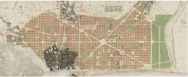
According to the project of Cerdà a new mesh is superimposed on the existing fabric. The ancient city is joined to the new plot pending the replacement of the old fabric. The modern city should be as homogeneous as possible to ensure the equivalence of all building lots. The innovation of Cerdà is mainly in the design of streets and blocks. The roads are 20 meters wide unless the principal axes of 60-80 mt. Isolates a side of 113 m with four chamfers of 20 meters that form the spaces of public report (squares) and facilitate the movement roadway. The build ability is initially provided by Cerdà only on two sides of the block in the different possible combinations. The 65% of the batch is intended to obtain a green settlement density of about 250 ab / ha (Fig 2.3).
Fig. 2.3: Cerdà blocks design (Cerdà. Pionero del urbanismo moderno. Ministerio de Fomento, 1998 http://urban-networks.blogspot.pt/2012/11/rompiendo-moldes-barcelona-y-madrid-se.html)
13 The implementation Ensanché4 already since 1860 does not take place in accordance with the principles of Cerdà. The compliance with the texture and shape of the road blocks have become the strong point of a process of expansion that lasted decades.
The weaknesses were:
a) the process of densification, in part spontaneously in part determined by the pressures of real estate rental, which has undermined respect closed courts instead of the opened block with consequent sharp increase in building density
b) the non-implementation of many green areas and services provided
Fig 2.4: Cerdà master plan for Barcelona (Plano de los alrededores de la ciudad de Barcelona y Proyecto de su Reforma y Ensanche, 1859
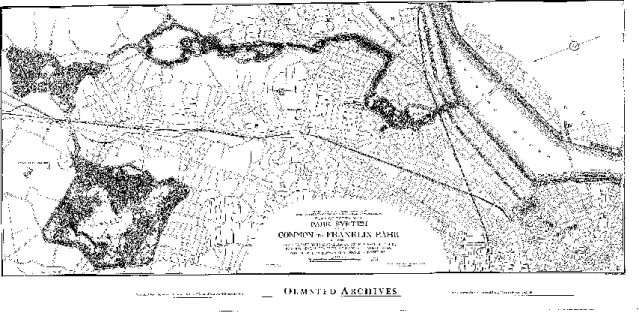
http://urban-networks.blogspot.pt/2012/11/rompiendo-moldes-barcelona-y-madrid-se.html) 2.06 OLMSTED AND THE AMERICAN MODEL
In 1865, with the proposal to merge the College of California at Berkeley to the City of Oakland and the nearby hills and arranging linear park in the valley of Strawberry Creek, Frederick Law Olmsted5 presents the idea of parkway that exposes three years after imagining integrate other parks.
His interest was not so much directed to isolated project of the park, but the continuity of public spaces, "if for each park will exploit the characteristics of the site and will take into account the limitations they impose, the result will be much more interesting and much more valuable than it would be if you follow the current setting, which tends to consider every park, big or small, as a thing in itself, which does not
4 Ensanché: new implement of a city, usually due demographic increasing
5 Frederick Law Olmsted (Hartford, April 26, 1822 - Belmont, August 28, 1903) was an American landscape architect and
14 benefit from the relationship with the other parks and they do not give any value added "(Zapatka C., 1987).
Frederick Olmsted propagated a vision of urban green as highly topical: he caught horticultural aspects at the same time, also sanitation and economic relations around the green areas. He wrote: "Our country has entered a phase of development in which the well-being depends on comfort, safety, order and economy of the life of the big city. It cannot thrive regardless of their "(Girau L., 1988).
The actuality of the speech of Olmsted lies in the constant search for a balance between public and private spaces. Olmsted, in fact, tried to address this issue by bringing extreme care in the definition of common-use areas and areas for private use. Such attention aimed, on the one hand, to prevent the owners of individual lots intervene arbitrarily according to his wishes and the other was acting with the aim to recreate an environment that possessed a communal life is very similar to a small citizens.
In fact, the Emerald Necklace (Fig. 2.5), or the green necklace around the city of Boston, was interested in nineteen municipalities and it was configured as a continuous system of parks, green spaces for play, nature reserves, "park road" that put in communication the city centre with the southern suburbs and the non-urbanized territory, thus giving the city an urban structure extremely modern, as well as a widespread environmental quality.
The validity of this way of understanding the green in the city, or better human settlements within the natural environment, mainly resided continuously in the scheme of flexible and differentiated open green spaces. In addition, the association for environmental protection helped to give identity to the local communities with significant implications both in anthropological and sociological terms.
15 The lesson of Olmsted spread very early in the metropolitan-regional scale and then in the big cities of the United States becoming the basis of the American branch of the American Park Movement, a proponent of urban development fell within the natural realities.
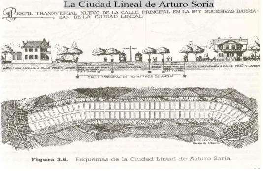
2.07 LA CIUDAD LINEAL ARTURO SORIA Y MATA
Arturo Soria y Mata6 (1844-1920) was a Spanish engineer of the same period of Howard. Initially involved in politics, later focused on the technical studies and several industrial initiatives. He was deeply concerned with the problems of urban traffic in Madrid, where in 1875 was created the first tram line.
Among the theoretical proposals of particular interest there is the “ciudad lineal”, linear city (Fig. 2.6), published in 1882 in the Madrid newspaper El Progreso. Strongly critical towards the traditional congested city, developed concentrically around a centre, Soria y Mata proposed, as an alternative, a tape of limited width but of indefinite length, the path from one or more railways along the axis.
Fig 2.6: Ciudad Lineal (http://www.catedu.es/matematicas_mundo/CIUDAD/ciudad_lineal.htm)
The main road would be 40 meters wide, tree-lined and covered in the center by an electric railway (Ferrocarril); stringers would be about 200 meters long and 20 wide, buildings would only cover one-fifth of the land. Soria y Mata imagined a city of extensive isolated colony: in minimum lot size of 400 square meters, only 80 would be for housing and the remained gardens.
16 In this way, he thinks that he could solve all the problems of urbanism derived from the circulation. The project for the “ciudad lineal” comes to the conclusion, as well as Howard, who form the most logical for a city where waste less time as possible in the movement: this object is achieved thanks to the wide central road, allowing traffic flowing and smooth, and the electric railway. In addition, the city-linear has the advantage of not being limited as the garden city, but to be able to develop dynamically.
M. Ragon7 in the "History of architecture and modern urbanism" harshly criticizes the project of Soria y Mata:
"Nevertheless the linear city had the disadvantage of not having any real center and being characterized by a great monotony, resulting from developments mechanical and not organic."(M. Ragon, 1971)
In the “ciudad lineal”, built near Madrid in the last decade of the nineteenth century, Soria y Mata tried to put into practice his model, designing a linear city horseshoe in the south-east of Madrid, 58 km long. The construction of the railway line on which to base the city was started in 1890. Soria y Mata believed that the initiative should remain in private hands and that there should be no public scrutiny; this increased however the difficulties of realization, preventing the use of land expropriation.
At the end of Soria y Mata managed to bring about a quarter of the horseshoe, but he left to private initiative freedom depriving the ciudad lineal of characters regularity expected in the theory. Later, the town was incorporated in the outskirts of Madrid, losing almost all of its original character.
The idea of Soria y Mata was taken around 1930 in the USSR, where the soil had been nationalized: his plan for the city-linear, which in truth is rather simplistic, was the basis of the urban plan for Stalingrad. The city, which stretches for 65km along the Volga, consists of six parallel bands: the river, parks, housing, circulation, green area, the railroad.
2.08 HOWARD AND THE GREEN BELT
In 1902, Ebenezer Howard8, who first coined the term Green Belt, published the book entitled Garden Cities of Tomorrow, a great success and one of the most widely read and translated texts within the urban culture. The purpose of the reflections of Howard was to limit the growth of cities in order to reduce their crowding, improving their housing conditions and health.
7 Michel Ragon ( June 24, 1924) is a French writer, critic of art and architecture.
17 This objective was pursued by blocking the peripheral development of the major cities and transferring it into a crown of the garden city of limited size, separated from the central city through green belts of agricultural land. Howard thought especially about London, which even then had reached two million inhabitants; but the model was re-proposabled for any big city who knew a strong development activity and population.
The solutions proposed by Howard are placed between urban design, urban sociology, economy and agriculture. For example, some policies to address urban issues were: the decrease of population pressure on large cities, land reform to reduce the cost of urban land and facilitate the solution of the housing problem, building controlled size communities and tend to be balanced in the relationship between residence and jobs.
The urban layout of reference was particularly influenced by the design of the proposed London by John Claudius Loudon9 in which bands of green alternated with new expansions: “Every time a citizen is going to extend beyond a diameter of half a mile, we believe that you should identify a breathing space to leave in built for the benefit of the health of the poorest part of the population” (E. Howard, 1902).
Lewis Mumford10, who was an enthusiastic supporter of the theories of Howard, wrote in his book “The city in history”:
“He understood that, once you reach the optimum, a city no longer has to further increase in area and population, but fit into a broader context that has the advantages of large number of people and equipment on a large scale.”(L. Mumford, 1961).
The underestimated economic aspects of capitals confined Howard’s action and he was able to achieve only two garden city: Letchworth and Welwyn also destined to be absorbed by the large macro-region of London. Howard's model was based on three concentric rings: services, residence and work that suggested a first hierarchy from the centre to the periphery; although this hierarchy was attenuated by districts, radially, moving from the periphery to the central garden. The districts were combined into a single residential system, as defined by Grand Avenue, and formed a functional and symbolic counterweight to the central park (Fig.2.7).
9 John Claudius Loudon (8 April 1783 – 14 December 1843) was a Scottish architect and garden designer. 10 Lewis Mumford (Flushing, 19 ottobre 1895 – Amenia, 26 gennaio 1990) was an American urban planner.
18 Fig 2.7: Howard Green Belt plan (https://www.pinterest.com/pin/367465650816940195/)
The attempt by Howard to build a social city resulted in the promotion of a system constantly in equilibrium because it is constituted by complementary components and cooperatives; his idea of the green belt was to be understood in the perspective of a city socially mobile: a series of small communities of up to sixty people, separated by a narrow belt of open countryside which founded a green space. The organizational model of Howard drew inspiration from a behavioural view: man is as subject to two magnets, the city, which attracted him with the lure of wealth, social relations, culture and the campaign that attracted him as a symbol of health and grandeur of nature. From this perspective, it follows, according to Howard, "that the city and the country must be married, and this joyous union will spring a new hope, a new life, and a new civilization."(E. Howard, 1902)
The aspects that are not always mentioned in the Howard’s model garden city concern the agriculture. In fact, outside the railway line were placed community gardens, orchards, pasture for cows. The plan also provided some farms, as well as smaller units within which a family could live, subsisting on both the external productions with both of those fields. In addition, a market town connecting farmers and citizens. The rail network, urban inserted in the settlement, was able to make it simple and inexpensive transportation of excess products to many other destinations.
19 The Green Belt plays a crucial role in the Second World War when it becomes crucial counter the massive urbanization typical of those years. In 1944, in fact, during the preparation of the Plan for the Greater London, by Patrick Abercrombie, it was planned an annular band of 8 km of agricultural and forestry areas no longer permitted as construction land. The Green Belt is configured so as the third ring of a concentric series which, starting from the core of the compact city, that coincides with the centre of London, proceeding with a second ring of suburbs, and ending with the campaign outer (fourth ring) where it was planned the construction of satellite cities (new Town).
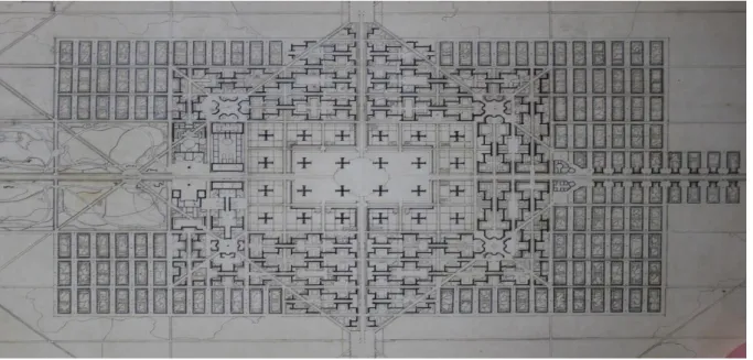
2.09 LA CITÉ INDUSTRIELLE OF TONY GARNIER
With Tony Garnier11, urban utopia definitively separates into its two components: planning and policy. From now on, the design is neutral, allowing a burst design that will reach its climax in the activity of Le Corbusier. Often the cité industrielle (Fig.2.8) was opposed to the garden city, but in reality it has many points in common with Howard's plan, as well as with the whole tradition of nineteenth-century utopian.
Garnier gives autonomy to its economic and cultural city, reserved half of the land to public parks and planned for a population of 35,000 people; then he divided it into different zones. He imagined a chessboard, a characteristic element of the utopian tradition, and he placed, as the backbone of the cité industrielle (which will be only 600 meters wide), the electric tram, similar to what was done by Soria y Mata for his ciudad lineal, but at the same time he did not try to dilute the city in the countryside, as Howard did.
He designed his industrial city from the first to the last building, thereby focusing mainly on the technical aspects. It had two significant innovations: it adopts, for all buildings, reinforced concrete and adorned them with a style bare. In 1904 Garnier completed his elaborate and presented it in an exhibition in Paris; the work was published in 1917.
He wrotes:
"Studies of architecture that we introduce here, in a series of tables, concerning the organization of a new city, the industrial city, since most of the new city, which will be based from now on, will be due to reasons industrial order, so we considered the more general case. On the other hand in a town like this all the applications architecture can find a place with good reason, and there is the opportunity to examine them all.
11 Tony Garnier (Lyon, August 13, 1869 - Roquefort-la-Bédoule, February 19, 1948) was a French architect and town
20 By assigning importance to our city average (assuming that it has about 35,000 inhabitants) have always aimed for the same purpose, to conduct research in general, which would not have been justified by the study of a village or a very large city. Even with this in mind we have assumed that the land is located where all the buildings including mountainous parts and a plain, crossed by a river.
In the plains the main workshop is located at the confluence of rivers. Above it, on a plateau develops the city that is in turn under the sanitary buildings: both the city and the health care facilities are protected from the wind and exposed to the south. Each of these areas is constructed so as to be expandable in the future anyway. At the center of the city are a great stadium, the school campus and the city center. The leisure center is located on the south. All functions are strictly separated. The tram provides public transportation in the city, linking the center to the periphery, where are located the farm model. A railway also runs between the factory and the city in the valley, ensuring links with the outside world; it terminates in a central underground station. "(T. Garnier, 1904).
Garnier also prepared regulations, one for each specific sector (construction, health ...); those already gave for granted that certain changes have taken place in the social order without which there would be applicable: the administration has the free disposal of the soil and procures bread, water, meat, milk and medicines. There are no plans for barracks, nor churches, nor the courts, nor even a prison and a police station: according to all that Garnier had no reason to exist in a socialist society.
The residential neighbourhoods are made up of houses aligned in a uniform grid of streets. The land is divided into blocks of 150 meters in an east-west, and 30 meters in a north-south direction. These blocks are in turn divided into lots of 15 square meters on a side, facing then always with a part to the road. A building can occupy more than one lot, but the built-up area must be less than half of the total area, the rest is intended as a public garden. This arrangement permits to cross the city in any direction, regardless of the roads and the soil of the city, taken as a whole, is like a big park, with no fences to restrict land.
Garnier never tried to realize his “cité industrielle”, who remained only a plan on paper; however, he had the opportunity to apply his principles to a large city, Lyon, where he went to live in 1904. Garnier had a considerable influence on the thinking of the twentieth century architecture and urban planning. Michel Ragon writes:
"With twenty years in advance Tony Garnier defined what would be the" international style "and settled forty years in advance those principles of urban design that will mark the Charter of Athens (1943)."(M. Ragon, 1972).
21 Fig 2.8: Citè industrielle
(https://www.studyblue.com/notes/note/n/lecture-07-city-suburb-and-the-anti-industrial/deck/11269690)
2.10 LE CORBUSIER AND THE FUTURE VISION
After the proposals of Howard with green belts and garden cities in continental Europe, between 1925 and 1930, was spreading a theory line called rationalist which draws its principles from the above proposals of Le Corbusier12, considered the greatest exponent of the Modern Movement. The term rationalism is meant to indicate the need to create a general vision that exceeds the specificity of places, highlighting recurring aspects of the human condition and is committed to providing repeatable solutions everywhere.
The inability to grasp the real needs expressed by the population, in reality so varied (for cultural, religious, but also the aspirations, opportunities, etc.), reducing them to a few primary functions, let Le Corbusier to propose a functionalist city, nicknamed "machine à habiter" or city car, due to the fact that there are social implications extremely limited.
The functional city, finally to address the fast-paced industrial development, the intense immigration, poor sanitary conditions, as well as the changed conditions of production due to the emergence of the capitalist model, pursues the search for appropriate technical solutions.
In the context of utopian city and city planning, Le Corbusier is one of the pioneers who introduced the idea of living in a city that is actually planned, designed and then built. He forced people to think what
12 Le Corbusier, the pseudonym of Charles-Edouard Jeanneret-Gris (La Chaux-de-Fonds, October 6, 1887 -
22 it will be like to live in an environment that is predetermined. At the end he succeeded in actually building such kind of environment. Cities are necessarily the geographic centres of people, activities and services. The urban form and layout of cities are familiar to most people.
As with Broadacre City13, Le Corbusier's Radiant City (Fig. 2.9) was founded on technological advances. But he rejected Howard's belief in cooperative control and Wright's admiration of individual creativity. Le Corbusier believed that only a dictatorial way of planning and design was equipped to "inaugurate the age of harmony" and dedicated his 1935 book to the discussion of this context called The Radiant City.
The most striking element of Le Corbusier's approach is his strict adherence to geometric form, regularity and standardization. In his description of “A Contemporary City of Three Million Inhabitants” he states: "The city of to-day is a dying thing because its planning is not in the proportion of geometrical one fourth. The result of a true geometrical lay-out is repetition, the result of repetition is a standard. The perfect form."(Le Corbusier, 1929)
Fig 2.9: Radiant City (http://www.fondationlecorbusier.fr/)
2.11 CLARENCE STEIN AND THE AMERICAN GARDEN CITY
In 1923, Clarence Stein14 founded an association called Association study of American regional planning (RPAA) which had the objective to introduce the concept of the Garden City of Ebenezer Howard in America.
13 Broadacre City was an urban or suburban development concept proposed by Frank Lloyd Wright
14 Clarence Samuel Stein (June 19, 1882 - February 7, 1975) was an American urban planner, architect, and writer, a major
23 For its most influential members, Stein, Lewis Mumford, Benton MacKaye, and Henry Wright, car use is associated with the national distribution of low-cost electricity and it was the topic to encourage communication, decentralization of population and industry, and finally autonomy from industrial areas.
The planners, Clarence Stein, Henry Wright realized their ideas by City Housing Corporation (CHC), a private construction company. However, the project resulted in bankruptcy and the concept did not survive the Second World War and remained on the market only the concept of "garden suburb".
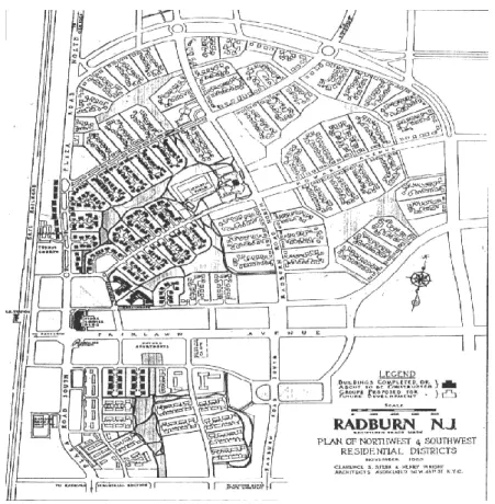
Stein and Wright planned the "Sunnyside-city" or interventions related to small parts of New York, but then they wanted to create a new city in a deserted area rather than adapt to a pre-existing urban grid, in particular, they were interested in the monotonous landscapes of suburbia created precisely by the urban systems in the grid. In 1927, then it was bought by the company CHC land to build Radburn (Fig. 2.10) in Fair Lown, New Jersey 12 miles from New York.
One of the fundamental aspects of the project idea was linked to the growth of cars that occurred in those years and their relationship with pedestrians through five key points:
1 - Use of large blocks to create a single large district;
2 - A hierarchical system of roads where each type had its specific function: service lanes, roads that revolved around the super blocks, the main arteries to connect the traffic of various sections and finally highways to connect the various communities;
3 - Complete separation of paths pedestrians / vehicles and within neighbourhoods there were only footpaths;
4 - Parks within neighbourhoods as the backbone of pedestrian movement by forming a continuous system of parks;
5 - Dwellings designed in such a way that "turn" around the parks doing so lounges and bedrooms were oriented towards the pedestrian and the service rooms looked out on the streets of service.
Radburn was a sort of "neighbourhoods of education" institutions and recreational centre of development. The elementary school is located on the Northeast corner of a super neighbourhood that overlooks the park. The districts of the shops and offices are located in the middle of the city.
In fact, every neighbourhood in the initial project was meant to have the shops and primary school, but with the crisis, they failed to develop the project in full. Radburn seems to contain a mix of commercial and public recreation areas and even mix of house types which are grouped into several blocks lying around a focal point. The shopping area is surrounded by multi-family homes.
24 The great economic depression of 1929 limited the project that was initially intended to cover 1 miles square15 arrived only at 149 acres and 5000 residents in 1960. Although Radburn was an innovation from the perspective of the residential but was a financial failure due the crisis lasted until World War, now days the project has become a dormitory town due the proximity to New York.
Fig 2.10: Radburn plan (https://www.pinterest.com/pin/323062973241554760/)
Clarence Stein wrote: "Although there are different reasons, the basic requirements of the defence are similar to the practical needs of the good life and the industrial economy. For peace, as well as for war, the first requirement is to spread rather than concentrate. Yet, new industrial and residential community that they had envisioned in the model of Radburn, separated by green belts and spaces for gardens, were quickly reduced to Levittown (1947) and its clones - the suburbs enormous, amorphous and infinite, dominated by mass produced homes, cars, malls, parking lots and culs-de-sac.” (C. Stein, 1945).
2.12 THE MODEL OF WRIGHT
Frank Lloyd Wright16 proposed a more thoroughly decentralized city. He proposed that “the city of the future” would be without walls, a city of the Wanderer, where mobility had brought freedom." (Fishman 1977). Wright's “Broadacre City” (Fig.2.11) was semirural, with the homestead considered the
15 1 mi = 2.58 km ²
16 Frank Lloyd Wright (Richland Center, June 8, 1867 - Phoenix, April 9, 1959) was an American architect, one of the most
25 conceptual centre. Urban facilities in this proposed city were separated by vast natural and agricultural environments, and were connected through the use of automobiles and personal helicopters.
Fig 2.11: Bodoacre City (http://outlaw-urbanist.com/blog/index.php/viewpoint-theory-perfect/frank_lloyd_wright_1934-35_broadacre_city_plan_model-2/)
Wright's ideas went beyond the design of cities to proposing radical change in the way that people lived and were governed. These ideas stemmed from advances in technology which were becoming widespread at the time. Wright's believed that the increasing ubiquity of the cars and developments in electronic communication could lead to an effective dissolution of the city in favour of more widespread, decentralized communities. He proposed that all families should be allocated in a plot of land of a minimum size of one acre.
Each family would own, at least one car and most houses would contain some sort of laboratory or workshop, making working from home commonplace. The large number of houses built on small plots of land for individually owned purpose would produce an environment containing a great deal of variety. Wright thought that this would produce a distinct character underlying the individual designs at the county level but would also produce a large variety of architecture across the country. All needs and services such as food, power and education would be produced and consumed locally.
In particular, rejecting the possibility of gradual improvements of the old city, their designers reconsidered the very principles of planning, applying a completely new cities; trying to combine the spatial form with the socio-economic form of society as a whole. The three cities imagined by Ebenezer Howard, Le Corbusier, Frank Lloyd Wright represent alternative societies, utopian visions of an
26 environment in which man could live in peace with others, in harmony with nature and thus forms the ideal of a society industrial.
Robert Fishman, in the criticism of the proposals of Howard, Wright and Le Corbusier stated that in the seventies had lost confidence in what united the three utopians, or that the belief that the solution to an urban problem could exist in isolation:
"The city ideals of Howard, Wright and Le Corbusier were not apart from most modern solutions. They have been replaced by the belief that there are no solutions. His deep origin I believe is the loss of confidence in the reality of a good or common purpose that can become the foundation of urban life” (R. Fishman, 1977).
The composition of the city evolves over time: a spatial structure initially favourable in the economic, environmental and social conditions may evolve towards a less efficient as well as vice versa it is possible to move towards more sustainable urban forms.
The urban form has been defined by Kevin Lynch17:
"The shape of the settlement to which we usually refer to as physical environment is normally understood as the intertwining space of large and inert objects that make up the city: buildings, roads, public services, the hills, the rivers and perhaps the trees (...). The shape of a settlement is the spatial structure that houses the activities of the people but also the flow that comes with it."(K. Lynch, 1960).
Therefore the shape is the result of the aggregation of a number of repetitive elements that combine basic differently, giving rise to different weaves always, however, consist of the same objects and the same activities. Understandably, at this point, the belief that there is a complex relationship between urban form and sustainable development that before acting on it is possible to obtain a better quality of life.
2.13 SPRAWL CITIES
In 1937, Earle Draper of the Tennessee Valley Authority used the term "urban sprawl" for the first time during a national conference of planners. It means a kind of urban development typical of big cities, generated unwanted social effects, especially in the West Coast as main example Los Angeles.