1Programa de Pós-Graduação em Geociências, Instituto de Geociências, Universidade Federal do Rio Grande do Sul – Porto Alegre (RS), Brazil.
E-mail: [email protected]
2Centro de Estudos de Geologia Costeira e Oceânica, Instituto de Geociências, Universidade Federal do Rio Grande do Sul – Porto Alegre (RS), Brazil.
E-mail: [email protected]
3School of Geography & Environmental Sciences, Environmental Sciences Research Institute, Ulster University – Coleraine, Co. Londonderry, Northern Ireland.
E-mail: [email protected]
4School of Agriculture, Earth and Environmental Sciences, University of KwaZulu-Natal – Durban, South Africa.
*Corresponding author
Manuscript ID: 20170133. Received on: 11/10/2017. Approved on: 08/03/2018.
ABSTRACT: The Rio Grande do Sul (RS) coastal plain area (33,000 km2) had its physiography modified several times through the Quaternary, responding to allogenic and autogenic forcings. The Patos Lagoon covers a significant area of RS coastal plain (10,000 km2), where incised valleys were identified in previous works. About 1,000 km of high resolution (3.5 kHz) seismic profiles, radiocarbon datings, Standard Penetration Test (SPT) and gravity cores were analyzed to interpret the paleoenvironmental evolution as preserved in incised valley infills. Seismic facies were recognized by seismic parameters. The sediment cores were used to ground-truth the seismic interpretations and help in the paleoenvironmental identification. Key surfaces were established to detail the stratigraphical framework, and seismic facies were grouped into four seismic units, which one classified in respective system tracts within three depositional sequences. The oldest preserved deposits are predominantly fluvial and estuarine facies, representing the falling stage and lowstand system tracts. The Holocene transgressive records are dominated by muddy material, mainly represented by estuarine facies with local variations. The transgression culminated in Late Holocene deposits of Patos Lagoon, representing the highstand system tract. The depositional pattern of the vertical succession was controlled by eustatic variations, while the autogenic forcing (paleogeography and sediment supply) modulated the local facies variation. KEYWORDS: incised valley; seismic facies; Quaternary; system tracts.
Incised valley paleoenvironments
interpreted by seismic stratigraphic
approach in Patos Lagoon, Southern Brazil
Eduardo Calixto Bortolin1* , Jair Weschenfelder1,2 , Andrew Cooper3,4
ARTICLE
INTRODUCTION
The response of coastal environments to sea-level varia-tions has received much attention (Schumm 1993, Shanley & McCabe 1994, Blum & Törnqvist 2000). River incision across the subaerially exposed continental shelf was followed by drowning during the transgression of the last glacial cycle (Dalrymple et al.1994, 2006, Blum et al.2013).
The Patos Lagoon, in southern Brazil, is the biggest bar-rier lagoon in the world (~ 10,000 km2), with a single
per-manent tidal inlet in Rio Grande (Kjerfve 1994, Toldo Jr.
et al. 2006b). Initial studies using high-resolution seismic data investigated Late Quaternary paleoenvironments in the Patos Lagoon (Weschenfelder et al. 2006, 2010a, 2014), whose results established a general and regional geological framework.
This study provides an individualization of seismic units, with a more detailed facies description, allowing the interpretation of system tracts and correlation with the regional sea level curve. The aims are to understand paleovalley formation and subsequent evolution, and to investigate their role in postglacial evolution of the Patos Lagoon system.
Regional setting
oldest to youngest, as Barriers I, II, III, and IV (Villwock
et al. 1986). Barrier III is the youngest Pleistocene barrier, which deposits are related to Marine Isotope Stage (MIS) 5 and it, together with the Holocene barrier (IV), encloses the contemporary Patos Lagoon.
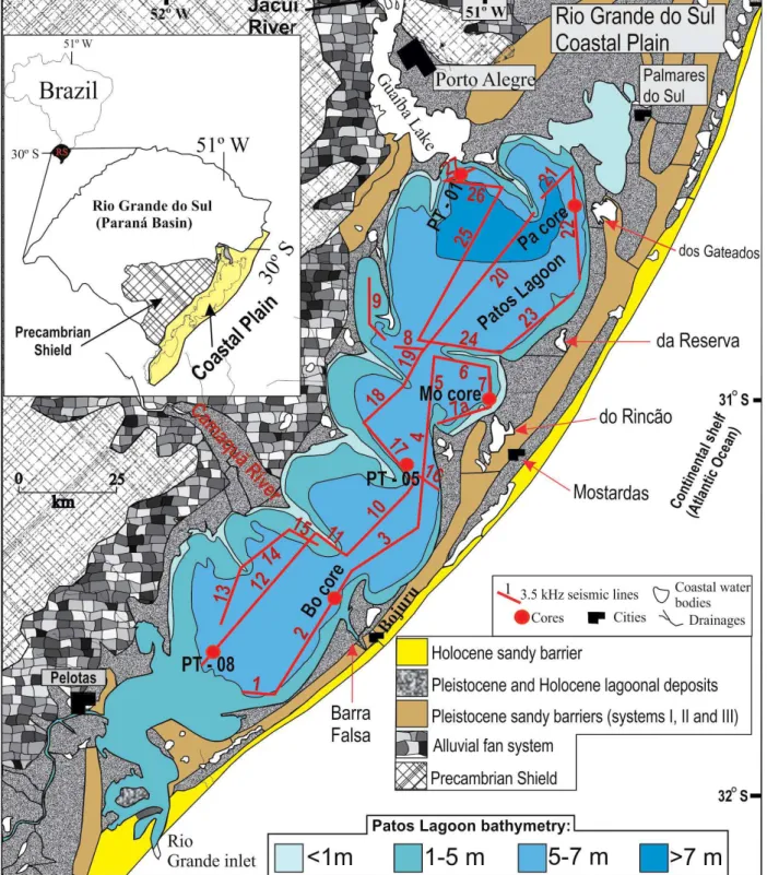
The Patos Lagoon is oriented NE-SW. It is about 240 km long, with average width of 40 km, and the surface area is ~ 10,000 km2 (Kjerfve 1986, Toldo Jr. et al. 2006b). The
sin-gle permanent connection with the ocean is the Rio Grande channel, and the tidal range average in the lagoon is about
0.22 m (DHN, 2014). The lagoon receives freshwater of two main drainage basins: Jacuí/Guaíba Rivers, in the north, and Camaquã River, in the south (Marques 2005). These rivers are the main source of sediment into the lagoon. Several mor-phologic and hydrodynamic cells, partially separated by sandy spits, are present in the Patos Lagoon. The segmenta-tion process, as proposed by Zenkovitch (1959), is believed to be incomplete because of currents associated with fresh-water influx (Toldo Jr. 1991). The submerged relief of each lagoonal cell comprises two sections: the margins (< 5 m water depth) are mainly sandy deposits, over which grow sandy spits in water depths of circa 1 m depth; the central portion of the cells have an average depth about 6 m, and the deposits are mainly muddy sediments (Toldo Jr. 1991, Toldo Jr. et al.2006b).
Paleodrainage systems and related features were iden-tified in the lagoon during a seismic reflection survey (Weschenfelder et al. 2005; Weschenfelder et al. 2010a), as well on the adjacent continental shelf (Abreu & Calliari 2005). Weschenfelder et al. (2005) developed the first strati-graphic sequence approach, with a provisional seismic facies description, based basically on the internal configuration pattern of reflectors mapped on seismic line 2 (Fig. 1), but this previous study did not associate a specific facies with an individual paleoenvironment. An inland core was drilled in the landward projection of the paleochannel associated to Barra Falsa; it provided samples for multidisciplinary research involving lithology, palynomorph and diatom data. That study aimed to interpret the paleoenvironmental evo-lution of the paleochannel recognized by seismic data in seismic line 2 (Weschenfelder et al. 2008b).
Two Pre-Holocene phases of incision were identified by the mapping of unconformity surfaces, and by the relative position in the sedimentary sequence and by radiocarbon dates (Weschenfelder et al. 2005, 2010a, 2014). These inci-sions probably occurred during the Pleistocene, reach-ing its maximum durreach-ing the maximum regression of the Wisconsin Glaciation (Weschenfelder et al. 2010a, 2014). The upper paleodrainage systems recognized were formed during sea level fall of the Last Glacial Maximum (LGM), when the sea level was 120/130 m below the actual position and were infilled during Holocene. From 18,000 years BP, postglacial sea level rise caused paleovalleys drowning and infilling (Corrêa 1986, Weschenfelder et al.2008a, 2008b, 2010a, 2014, 2016).
Previous studies suggest the breaching of the Pleistocene Barrier III (Toldo Jr. et al. 1991, Barboza et al. 2005, Weschenfelder et al. 2008b, 2014, Santos-Fischer et al. 2016, 2018). The pioneer study relating a feature named Barra Falsa in the eastern Patos Lagoon margin to a Holocene inlet was carried out by Toldo Jr. et al. (1991). Following,
few studies based on seismic stratigraphic, palynomorph and diatom analysis also corroborated this interpretation (Weschenfelder et al. 2008b, 2014, Santos-Fischer et al. 2016, 2018, Bortolin 2017, Bortolin et al. 2018). Besides Barra Falsa, other features in the Patos Lagoon eastern mar-gin, such as Rincão Lake, Reserva Lake and Gateados Lake (Fig.1), also could be indicative of Holocene inlets (Bortolin 2017; Bortolin et al. 2018).
Jacuí and Camaquã rivers were responsible for excavat-ing the main paleovalleys recognized in Patos Lagoon sub-strate, developing different waterways during the Pleistocene (Weschenfelder et al. 2010a, 2014, Baitelli 2012, Bortolin 2017). The valleys developed were partially infilled and are still recognizable in the Patos Lagoon bathymetry (Bortolin 2017; Bortolin et al. 2018).
MATERIALS AND METHODS
About 1,000 km of high-resolution (3.5 kHz) seismic profiles were collected in the Patos Lagoon (Fig. 1), aboard the research vessel LARUS. Positioning was by differential global positioning system (DGPS). The data was acquired by a GeoPulse Sub Bottom Profiler, from GeoAcoustics (Great Yarmouth, United Kingdom), and was processed in SonarWiz software (Chesapeake Technology, California, United States). These seismic data were analyzed in pre-vious works with distinct approaches, but still provide a unique source of information and are necessary to sup-port our interpretations (Weschenfelder et al. 2005, 2006, 2008a, 2008b, 2010a, 2010b, 2014, 2016). Average veloc-ities applied were 1,500 m/s for the water and 1,650 m/s for sediments (Jones 1999).
The concepts established by Mitchum et al. (1977) were applied to limit the depositional sequence, to define the seismic units and to describe the parameters of each facies. Throughout this work, the generic term discontinuity
is applied to the surfaces, each of which represents a break in the continuity of physical character, either by contrast in acoustic impedance or the geometric relationship between strata. The term unconformity is applied to the sequence boundaries, specifically when a hiatus or erosion is identified. The criteria used to differentiate seismic units are the same as those used to separate the depositional sequence into stratigraphic units (system tracts): strata stratification pat-terns (internal configuration of reflectors), position within the sequence, and types of bounding surface (Catuneanu 2006, Catuneanu et al. 2011). Therefore, in this work seis-mic units are relative to a specific system tract.
internal configuration, external geometry, and irrespective of position in the depositional sequence. Seismic facies were used as a tool to interpret the paleoenvironment based on James & Dalrymple (1992). Accordingly, a specific seismic facies (paleoenvironment) could occur in distinct system tracts (stratigraphic/seismic units).
Contrasting acoustic impedance surfaces were minutely described. Care was taken to disregard multiples and also “bottom simulating reflectors” (Emery & Myers 1996), which can be produced in zones with gas in the sediment. The continuity of some seismic surfaces was obliterated by gas-related acoustic anomalies in some locations.
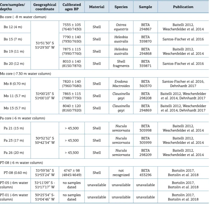
A stratigraphic calibration was carried out using sedi-ment cores after the seismic interpretation. Three Standard Penetration Test (SPT) boreholes, located exactly on the seismic profiles, were analyzed. In addition, three grav-ity cores of 3 m average length were collected. Shells were selected for radiocarbon dating (C14), to establish the age
of some units and to correlate them with the stratigraphic framework (Tab. 1). Some of the radiocarbon ages pre-sented in Table 1 were published by previous works, but the shell species were not reported (Santos-Fischer et al. 2016, Weschenfelder et al. 2014). Radiocarbon ages with the corresponding species were published by Baitelli (2012),
Table 1. References of cores and radiocarbon dating samples published previously and in the current work, modified from Bortolin et al. (2018). Compilation of shell species with organized references.
Core/samples/ depths
Geographical coordinate
Calibrated
ages BP Material Species Sample Publication
Bo core ( -8 m water clomun)
Bo 12 (4 m)
31º31’30” S 51º29’50” W
7535 ± 105
(7640/7430) Shell
Ostrea equestris
BETA 294867
Baitelli 2012, Weschenfelder et al. 2014
Bo 15 (7 m) 7790 ± 140
(7930/7650) Shell
Heleobia australis
BETA
359870 Santos-Fischer et al. 2016
Bo 19 (11 m) 7875 ± 115
(7990/7760) Shell Heleobia australis BETA 294868 Baitelli 2012, Weschenfelder et al. 2014
Bo 20 (12 m) 8010 ± 140
(8150/7870) Shell
Shell fragments
BETA
359871 Santos-Fischer et al. 2016
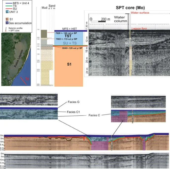
Mo core (-7.30 m water column)
Mo 8 (0.70 m)
31º00’25” S 51º00’10” W
7820 ± 140
(7960/7680) Shell
Erodona Mactroides
BETA 360370
Santos-Fischer et al. 2016, Dehnhardt 2017
Mo 11 (3.7 m) 7865 ± 115
(7980/7750) Shell
Clausinella gayi
BETA 298208
Baitelli 2012, Weschenfelder
et al. 2014, Dehnhardt 2017
Mo 13 (5.7 m) 8040 ± 120
(8160/7920) Shell
Clausinella gayi
BETA 294869
Baitelli 2012, Weschenfelder
et al. 2014, Dehnhardt 2017
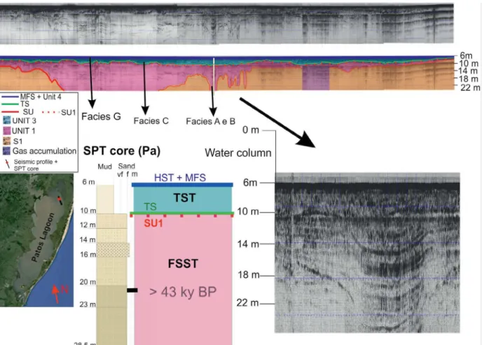
Pa core (-6 m water column)
Pa 21 (15 m)
30º32’52” S 50º42’54” W
> 43,500 Shell Nucula
semiornata
BETA 305998
Baitelli 2012, Weschenfelder et al. 2014
Pa 23 (17 m) > 43,500 Shell Nucula
semiornata
BETA 305999
Baitelli 2012, Weschenfelder et al. 2014
Pa 26 (20 m) > 43,500 Shell Nucula
semiornata
BETA 298209
Baitelli 2012, Weschenfelder et al. 2014
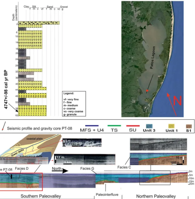
PT-08 (-6 m water column)
PT-08 (0.60 m) 31º39’56” S 51º53’24” W
4747 ± 98
(4845/4649) Shell not recognized BETA 453296 Bortolin 2017, Bortolin et al. 2018
PT-05 (-6m water column)
31º11’09” S - 51º17’17” W
no samples
dated unavailable unavailable unavailable
Bortolin 2017, Bortolin et al. 2018
PT-01 (-6m water column)
30º25’54” S- 51º04’46” W
no samples
dated unavailable unavailable unavailable
and the species nomenclature was reviewed by Dehnhardt (2017). These data were compiled in the current work and organized in Table 1.
Provisional descriptions of seismic facies were devel-oped in earlier studies (Weschenfelder et al. 2005, 2008b, 2010a), which focused basically on the paleochannel in the northern portion of seismic line 2, near the Bojuru region. Those works described channel infilling facies, but did not apply a uniform nomenclature to the facies. Seismic facies were described by Weschenfelder et al. (2005, 2010a) with-out paleonvironment interpretation, while Weschenfelder
et al. (2008b) associated the facies to paleoenvironments. Considering the previous studies, the current work standard-izes the nomenclature of facies, key surfaces, and sequences, extending this model to all recognizable features in the Patos Lagoon seismic data. Based on this, it provides a more con-sistent interpretation about the environmental evolution in the whole Patos Lagoon area.
RESULTS
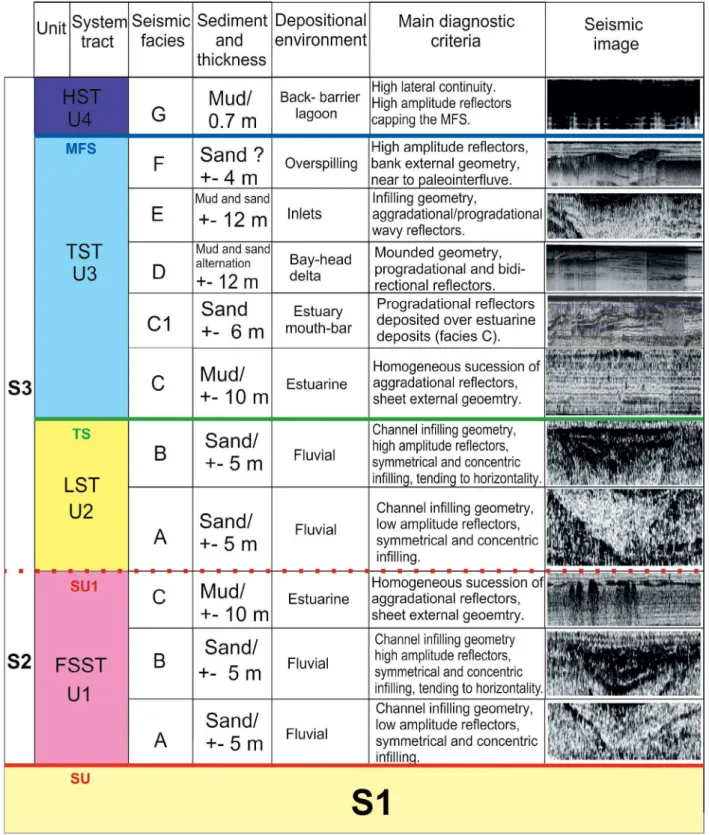
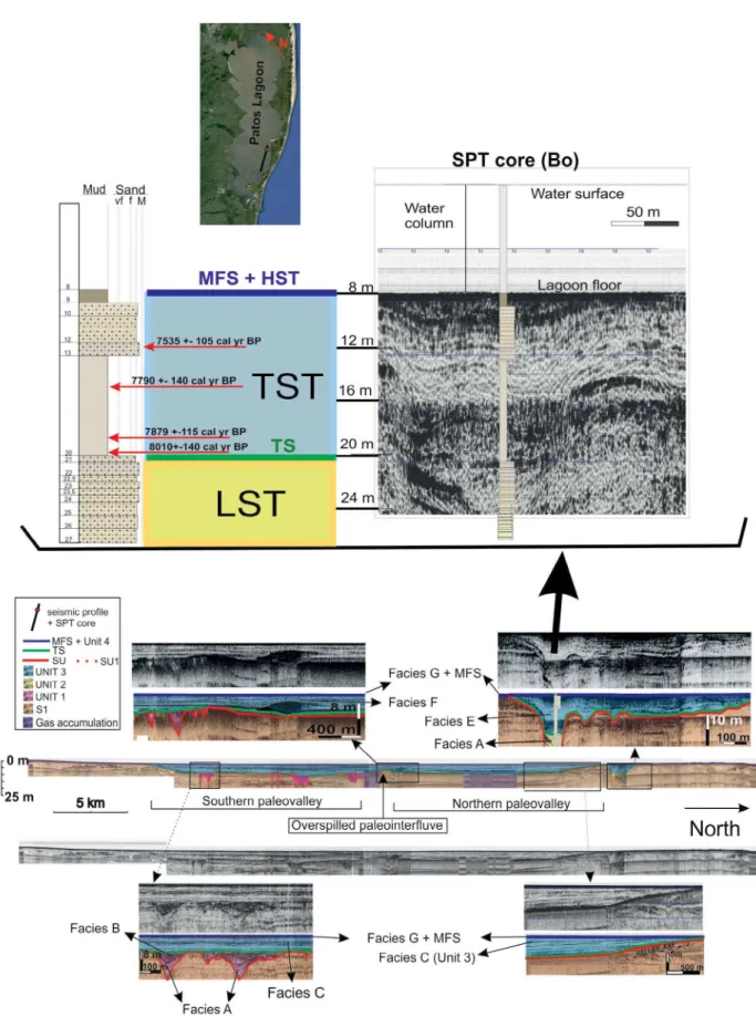
The acoustic signal penetrated about 30 m of sediment, encompassing the upper sedimentary package underneath the Patos Lagoon bottom. Three depositional sequences were identified, limited by subaerial unconformities (SU and SU1). The lowest sequence (S1) reveals multiple events of incision and subsequent infilling of the valleys. These are the oldest events recorded. The upper sequences (S2 and S3) reflect evolution from the peak of the Last Full Interglacial (LFI), isotope stage 5e (about 120 ky BP), to the present. Figure 2 synthesizes this stratigraphic framework.
Sequence 1 (S1) is the deepest recognized in the seismic data. The lower limit was not reached by the seismic signal. The upper limit is at an average depth of 17 m below the water level (6 m on average), and it is marked by a discon-tinuity surface, named here SU (Figs. 2, 3, 4, 5, 6), that truncates older strata. S1 reveals multiple reflectors, with parallel to sub-parallel configuration, good lateral continu-ity and variable amplitude. This sequence was first recog-nized by Weschenfelder et al. (2005), and named Sequence I, identifying it in seismic line 2 (Fig. 1). Subsequent seis-mic studies used the same terminology (Weschenfelder et al. 2010a, 2014, Baitelli 2012, Santos-Fischer et al. 2016, 2018, Bortolin 2017, Bortolin et al. 2018).
The lower and upper limits of Sequence 2 (S2) are limited by discontinuity surfaces, SU and SU1, which have similar seismic parameters (described ahead), but SU1 is topping younger deposits and has a lower truncation angle with older strata (Fig. 6). The lower limit of S2 is marked by SU, with truncation of S1 deposits (Figs. 3, 4, 5, 6). The upper
limit is marked by SU1 (Fig. 6), a very irregular and high amplitude surface, truncating in low angle the deposits of S2 strata, and small channels (< 2 m) can be recognized in this surface. This sequence is composed of Facies A, B and C of Unit 1 (Fig. 2).
The limits of Sequence 3 (S3) are well marked on the base by an unconformity surface, SU or SU1, depending on whether Unit 1 deposits were eroded or not deposited, and on the top by the Patos Lagoon floor. When Unit 1 depos-its are not recorded SU and SU1 surfaces are juxtaposed and are represented as only as SU. This sequence represents the post-LGM transgressive infilling event. Weschenfelder
et al. (2005, 2010a) described a few channel infilling facies of this sequence, in seismic line 2, associated with Bojuru paleochannel (Fig. 1).
Seismic facies
Seismic facies were identified by seismic parameters, such as amplitude, frequency, continuity of the reflections, internal configuration and external geometry. Sedimentologic sam-ples were tied to seismic data. Besides the classic parameters, the presence of gas also can be used to suggest the presence of some paleoenvironments (Weschenfelder et al. 2016).
Facies A (Figs. 2, 5, 6) comprises a 6 m-thick package of confined channel infilling reflectors, whose cross-sectional shape is concave upward. The reflectors are semi-transpar-ent, with low amplitude, low layering, inclined, low con-tinuity and high frequency. Sometimes a switch of pattern is distinguishable around the middle portion of the fluvial sedimentary package. This change determines the begin-ning of Facies B (Figs. 2, 5, 6), in which high-amplitude reflectors of medium continuity and low frequency onlap the subaerial unconformity surface. Facies A and B are inter-preted as V-shaped fluvial incisions, located at the base of U-shaped incised valleys.
Facies C (Figs. 2 to 6) consists of a homogeneous suc-cession with aggradational sediments. It shows reflectors with external sheet forms, low amplitude (rare exceptions),
high continuity (kilometrical scale), high frequency and well-formed parallel/sub-parallel layering. The layers are horizontal in the central portion of the valleys and tend
S1: Sequence 1; S2: Sequence 2; S3: Sequence 3; SU: subaerial unconformity; SU1: subaerial unconformity 1; TS: transgressive surface; MFS: maximum
flooding surface; FSST: falling-stage system tract; U1: Unit 1; LST: lowsand sytem tract; U2: Unit 2; TST: transgressive sytem tract; U3: Unit 3;
HST: highstand system tract; U4: Unit 4.
to be inclined when onlaping the valley’s axes, where they form a wedge shape. Some reflectors of Facies C show high amplitude and trap the gas accumulated in older deposits (Weschenfelder et al. 2006, 2016). Such trapping layers are interpreted as stiff muddy sediments and are mappable for long distances. The SPT cores Mo and Pa (Figs. 3 and 5) and gravity cores PT-05 and PT-01 described in Bortolin
et al. (2018) reached this facies, revealing a succession of muddy layers. These deposits are interpreted as estuarine sediments or sediments of evolving lagoons.
Facies D (Figs. 2 and 5) is a package in a mounded geom-etry, reaching more than 15 m thick, comprising bidirectional
and progradational reflectors. It is covered in a toplap by the Maximum Flooding Surface (MFS), that touches the contempo-rary bathymetry. An alternation between high and low amplitude reflectors is corroborated with core PT-08 (Fig. 5), reflecting intercalated sandy and muddy layers, that resisted gravity core penetration. Northward, the reflectors are more continuous and less inclined in comparison with the southward portion of the mound form (Fig. 5). The age of 4,747 ± 98 cal yr BP was determined for these deposits by radiocarbon dating carried out in sample shells at 0.60 m depth; the shell species could not be identified due to physical weathering (Bortolin et al. 2018). This is interpreted as a bayhead delta.
Facies E (Figs. 2 and 3) occurs within the remain-ing inlet channels and presents reflectors with a mixed aggradational/progradational pattern, variable amplitude, parallel to sub parallel, wavy, filling channel geometry, high frequency and variable continuity. In the upper portion, some scour created by reactivation of the chan-nels are present. Small variations in these parameters made Weschenfelder et al. (2005, 2008b) individualize this package in many sub-facies (in the Bojuru channel, seismic line 2). The current study grouped those sub-fa-cies into Fasub-fa-cies E, because for environmental evolution
analysis they have the same meaning. This facies is also described by Weschenfeder et al. (2010a) in paleochan-nels of seismic lines 2 and 7, reporting it as presenting multiple wavy reflectors, continuous to discontinuous, with variable amplitude, whose uppermost portion is trun-cated by modern reflectors (scouring), and is interpreted as channel infilling by estuarine and marine transgressive clays. Fossil assemblages identified in these deposits pres-ent a high marine influence (Santos-Fischer et al. 2016, Dehnhardt 2017) and are revisited in the discussion. This facies is interpreted as an inlet fill.
Facies F (Figs. 2 and 3) is a progradational/aggrada-tional package. It is typified by reflectors with high ampli-tude, low frequency, medium continuity, oblique and with the external geometry in bank. Facies F occurs next to a paleotopographic high, which is onlapped (from south-west to northeast) until over-spilling occurred, forming a bank geometry on the northeast side. Layers of Facies C conformably overlie the bank, indicating that Facies F was formed during an earlier stage of Holocene sea-level rise. This facies is interpreted as a sandy bank, generated by the sands eroded during the overspilling of a topographic high, which comprises pre-LGM substrate.
Facies G (Figs. 2 to 6) represents the thin layer (0.5 m) of modern sediments, deposited since the interfluves were flooded and the current back-barrier lagoon was established. This facies is the single one of Unit 4, whose lower limit is the MFS and the upper limit is the lagoon floor. It is characterized by high amplitude reflectors, with lateral continuity, capping all the previous deposits. The cores Bo, Mo and Pa show it as a muddy layer on the top of the sequence.
Seismic units
The sequences (S1, S2 and S3) were defined by Weschenfelder et al. (2014), separated by unconformity surfaces (SU and SU1). In the current work, seismic units will be organized within these sequences, correlated to a specific system tract, following the stratigraphic concepts proposed by Catuneanu et al. (2011). The seismic facies, identified in each seismic unit, will be interpreted as a spe-cific depositional environment (Figs. 2 to 6).
Unit 1
Grouped in Unit 1 are the early fluvial channel facies (A and B) and early estuarine facies (C). The Unit 1 is underlain by the SU surface, capped by the SU1 surface and is interpreted as the Falling-Stage System Tract (FSST). These deposits have a channel infilling geometry, with con-centric infilling reflectors, that become increasingly horizon-tal upwards as the channel is infilled. Radiocarbon dating revealed ages older than 43 ky BP; all three dated samples (Tab. 1) in U1 were of Nucula semiornata (Baitelli 2012, Weschenfelder et al. 2014).
On the top of U1 an unconformity surface can be iden-tified (SU1). This surface is represented by a high-amplitude, irregular reflector with several small channels (< 2 m depth) (Fig. 6). This surface was probably developed during succes-sive subaerial exposures of this coastal area along the FSST.
Unit 2
This unit is the record of the fluvial channel facies (facies A and B) formed during the LGM (Figs. 2 and 3). Such channels reached the lowest depths recognized in the Upper Sequence (> 25 m), in agreement with the lowest sea level position, around 120 m lower than the current level. It was reached by only one core (Fig. 3). The samples collected are fine to medium sands, with shell fragments.
These deposits have channel infilling geometry, with concentric infilling reflectors, increasing horizontality of strata upward as the channel is infilled. The stratification patterns (internal configuration of reflectors) of this unit show the same characteristics as the fluvial facies of Unit 1, hence they are interpreted as the same seismic facies (A and B). However, despite having the same physical characteris-tics, they are in distinct stratigraphic positions and there-fore represent different system tracts. Unit 2 deposits are over an unconformity surface and under the transgressive surface (TS).
Weschenfelder et al. (2005, 2006, 2016) recognized a close spatial association between gas concentrations in central portions of the lagoon with paleotopographic depressions, which could be caused by fluvial incisions and were infilled by transgressive sediments. The gas concen-trations are linked to Units 1 and 2 and provide clues to these units’ identification.
Unit 3
U3 exhibits mainly aggradational reflectors, secondarily progradational or mixed pattern, grouping estuarine (C), bay-head delta (D), inlet (E) and overspilling (F) facies. The base of U3 is marked by the TS, and the top is delimited by the MFS surface (both surfaces described ahead). U3 therefore comprises the Transgressive System Tract (TST). The cross sectional geometry of this unit is typical of U-shaped valley infilling (Gibling 2006) (Fig. 3), which has high width/depth ratios and increasing width oceanward. The valley widths are 35 km on average; the depths are variable, peculiar to each lagoon morphologic cell, but usually around 30 m.
Radiocarbon dating revealed Holocene ages (Baitelli 2012, Santos-Fischer et al. 2016, Weschenfelder et al. 2014) for these deposits (Figs. 3, 4 and 5). The shell species sampled for radiocarbon dating in Mo core were Erodona Mactroides
(8 m depth), Clausinella gayi (11 m depth), Clausinella gayi (13 m depth); for Bo core were Ostrea equestris (12 m
depth), Heleobia australis (15 m depth), Heleobia australis
(19 m depth) and shell fragments (20 m depth). The sam-ples are organized in Table 1.
Unit 4
Unit 4 caps all the previous deposits and is recognized in all seismic lines. Its basal limit is the MFS and the top is limited by the lagoon floor. One single facies (G) composes this unit; it has an average thickness of 50 cm, hampering the visualization in the figures, therefore the MFS and Unit 4 are represented together. Facies G represents the deposits accumulated since all the interfluves were flooded and the current back-barrier lagoon was formed.
Discontinuity surfaces
The discontinuity surfaces represent a switch in stratifi-cation pattern (a reflector’s internal configuration), beyond which a new group of facies with distinct patterns of reflectors occurs. They are generated by contrasts in acoustic imped-ance or changes in the geometric relationship between the strata, which are perceivable regionally and allow the iden-tification of seismic units.
The subaerial unconformity (SU) underlines the deposi-tional sequence S2. It is evidenced seismically by an irregu-lar reflector, of high amplitude, continuous for tens of kilo-meters, underlying the incised valleys. It is marked by the truncation of older reflectors and its upper limit is character-ized by the onlap/downlap of aggrading flooding reflectors.
The SU1 is represented by a high amplitude, irregular reflector, continuous for tens of kilometers which occur on the top of Sequence 2 deposits. Small channels (< 2 m depth) can be noted on this surface (Fig. 6). SU and SU1 are juxtaposed in case of hiatus of Sequence 2 deposits, being represented together as SU.
Mo core reached the juxtaposed surfaces, SU + SU1 (Fig. 4). The sedimentary sample collected (13.8 to 15 m depth) evidences this composite surface as a stiff sandy sub-strate, iron-oxide-rich, likely formed under subaerial condi-tions, such as pedogenesis and fluvial process. The deepest SU segments are located at the central portions of the val-leys, more specifically at the substrate of the fluvial chan-nels. On the other hand, the shallowest portions are located on valley interfluves and are thinly covered by sediment.
TS marks the transition from the early infilling facies, to the post-LGM transgressive facies. It is recorded as a high amplitude and continuous reflector, conformably overlying the earlier deposits or the subaerial unconformity surfaces. It appears juxtaposing the SU/SU1 segments where the flu-vial facies are not present.
is located about 50 cm depth. It represents the complete drowning of the interfluvial areas and the establishment of the modern geomorphological pattern of the modern Patos Lagoon.
DISCUSSION
Like other lagoons with non-migrating barriers (Benallack
et al. 2016), the Patos Lagoon favors the preservation of Late Pleistocene/Holocene geologic records, because the stable sandy coastal barriers minimize transgressive ravinement by ocean waves and tides. The microtidal range likewise lim-its tidal ravinement. Moreover, the majority of the deposlim-its in the lagoon are transgressive mud, allowing satisfactory acoustic signal penetration and facilitating gravity coring.
Paleodrainage systems were active on the RS coastal plain during pre-Holocene falling and lowstand stages, which exposed the Rio Grande do Sul continental shelf, when sea level was 120/130 m lower than the present level (Corrêa 1986, Weschenfelder et al. 2005, 2010a, 2010b, 2014, Baitelli 2012, Bortolin 2017, Bortolin et al. 2018). These moments are recorded in our data by discontinuity surfaces in the sedimentary sequence, SU and SU1.
Seismo-stratigraphic characteristics including irregu-larity of reflectors, high amplitude, continuity for tens of kilometers, truncation of older strata, iron-oxide-rich stiff sandy layer (attested by Mo core), as well as their position
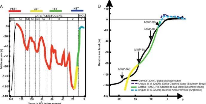
underlying incised valleys suggest SU and SU1 as subaer-ial unconformities, marking the period when the shelf was exposed (Corrêa 1986, Angulo et al. 2006, Nordfjord et al. 2006, Baitelli 2012, Weschenfelder et al. 2014, Bortolin 2017, Bortolin et al. 2018). These surfaces can be inter-preted as regional unconformities, because of their con-tinuity through the adjacent morphologic cells of Patos Lagoon (Figs. 3, 4, 5 and 6). They were generated during the Pleistocene glaciations, eroding previous deposits (S1), which were formed during the Last Full Interglacial (LFI) (Fig. 7), MIS 5e (Imbrie et al. 1984, Weschenfelder et al. 2005, 2010a, 2014, Baitelli 2012, Bortolin 2017).
Sequence 1 is represented by reflectors with high parallel-ism, good lateral continuity and variable amplitude. These pre-vious deposits (S1) probably were generated during a period of high sea level, likely are cohesive mud or cemented sandy barriers from paralic environments. This substrate can be very resistant to erosion, also can inhibit the lateral migration of early fluvial channels, generating the V-shaped channels (facies A and B), which were incised and infilled by vertical adjusts (Fielding et al. 2005; Gibling 2006).
Other researchers have also recognized differences in the architectural strata between initial phases of excavation (or early infilling) and late infilling of fluvial channels (e.g., Fielding et al. 2005). The early infilling phase (Facies A, Fig. 2) is represented by confined channel infilling, with reflectors of low amplitude, which are symmetrical and concentric. The final infilling (Facies B) is characterized
Figure 7. (A) Tentative of correlation between late Pleistocene high-frequency sea level changes and identified system tracts. Sea level curve based on Imbrie et al. (1984) Marine Isotope Stages; (B) detailed sea level curve for the area and surroundings, since Last Glacial Maximum (LGM), properly referenced in the figure.
by variable reflectors amplitude; some strong reflectors are common, and increase in horizontality of the layers upward. The amplitude homogeneity in reflectors of Facies A proba-bly represents an infilling by homogeneous sediment, while the variable reflectors of Facies B might reflect alternation between muddy and sandy sediments. This organized infill-ing architecture recognized in fluvial paleochannels contrasts with seismo-stratigraphic classical models (Nordfjord et al. 2006, Green et al. 2013) and are similar to the descriptions of Fielding et al. (2005) and Gibling (2006).
The rivers lose transport competence during subtle rel-ative sea level rises or stillstands that occurred since MIS 5e (Fig. 7A), adjusting their equilibrium profile by depositing bedload. Rivers unable to migrate laterally have to adjust their equilibrium profile vertically, aggrading symmetric and concentric bedload layers, forming facies A and B, which are recognized within the FSST and Lowstand System Tract (LST). The notable differences in basal and upper fluvial infilling (facies A and B) is associated to the adjustment of the river to changes in base level (Fielding et al. 2005, Gibling 2006).
Gas concentrations were recognized in central portions of Patos Lagoon, where paleotopographic depressions were infilled by transgressive fine sediments (Weschenfelder
et al. 2005, 2006, 2016). These paleodepressions could be generated or occupied by fluvial channels along regressive events and infilled during the subsequent transgressive event (Weschenfelder et al. 2005, 2006, 2016). Therefore, the gas records can help the mapping of the facies of Units 1 and 2 of the FSST and LST described ahead.
Falling-Stage System Tract
Classic studies based on Fisk (1944) applied the con-cepts of “forced regression” or “falling-stage systems tracts” as periods of incision with sediment bypass through the valley, associating the valley infilling with the lowstand and subse-quent sea level rising (Posamentier & Vail 1988, Van Wagoner
et al. 1990, Dalrymple et al. 1992, 1994, Posamentier et al. 1992, Zaitlin et al. 1994, Nordfjord et al. 2006, Green 2009, Green et al. 2013). The Falling-Stage System Tract term was applied by Catuneanu et al. (2011) in reference to depos-its accumulated after the onset of sea level fall, and, before the start of the next relative sea-level rise, this work was a nomenclature review about sequence stratigraphy.
Modern researchers have been contesting the classic incised valley models, especially the issues approaching inci-sion and complete sediment bypass; several studies were dis-cussed by Blum & Törnqvist (2000) and Blum et al. (2013). According to these researchers, simple incision cannot create a valley-scale feature; rather it is the superposition of sur-face dynamics that drives the widening of an initial channel.
These researchers contend that channel-belt construction and valley widening also increase the sediment input to the river mouth. However, these works affirm that while all rivers act as a bypass system to some degree, a significant percentage is trapped in the alluvial-deltaic clinothem during sea level fall. Finally, Blum et al. (2013) state that sediment bypass and fluvial deposition are not mutually exclusive and both processes occur during the sea level falling stage.
In the records presented in the current work, this sys-tem tract groups the deposits accumulated since the onset of sea level fall, occurred immediately after the LFI (MIS 5e), until the LGM. Unit 1 is representative of this system tract, limited by the unconformity surfaces SU and SU1; the stratigraphic position between two unconformity sur-faces suggests the successive exposure expected for this sys-tem tract. Facies A, B and C were recognized in this phase. Weschenfelder et al. (2014) associated these deposits with the period between 120–18 ky BP and named them S2.
The seismic records classified in this work as FSST have an external geometry of channel infilling type, reflectors with variable amplitude, good lateral continuity, tending to increased horizontality upward, onlapping the margins of the valleys and channels. Samples collected in Pa core (> 10 m depth) revealed these deposits as sandy sediments (Fig. 6), older than 43 ky cal BP (Weschenfelder et al. 2014). Diatom assemblages analyzed by Santos-Fischer et al. (2016) suggest the depositional paleoenvironment as marine-dominated with rare and uncommon freshwater, corroborating with the environment of N. semiornata species (Dehnhardt 2017), whose shells were used for radiocarbon dating of these deposits (Tab. 1). These fossils also provide information about the adjacent environment, which is import-ant in such dynamic coastal zones. The Late Pleistocene sea level fall was not constant and had minor rises in sea level during the process (Imbrie et al. 1984). The marine domi-nance reported by Santos-Fischer et al. (2016) suggests the sea as an adjacent environment extremely influential on coastal drainage systems, which had their incised valleys partially infilled by alluvial facies.
Paleochannels excavated the S1 during the early process of sea level fall, after MIS 5e (Fig. 7). Subsequently, gentle sea level rises (Fig. 7) probably forced the rivers to accu-mulate bedload in their channels, facies A and B of Unit 1. In topographically lower areas, the increase in water level formed early estuarine deposits, Facies C of U1.
2014, Bortolin 2017, Bortolin et al. 2018). This suggests that the FSST sediments were completely flooded again during the Holocene sea level rising, when they were cov-ered by the TST deposits (Figs. 2 and 3).
Lowstand System Tract
According to Catuneanu et al. (2011), the LST deposits accumulated after the onset of relative sea level rise, on the top of the FSST and the corresponding subaerial uncon-formity. In our records, the LST includes the package of deposits accumulated after the LGM (Fig. 7), during the onset of the post-glacial sea level rise. Unit 2 is representa-tive of this system tract and is composed of facies A and B. The LST deposits presented in our records appear directly over the SU + SU1 composite surface, where FSST were either eroded or not deposited (Fig. 3). The seismo-strati-graphic signature of these deposits is characterized by sandy packages, with reflectors organized with a channel infilling geometry, representing a symmetric and concentric infilling (Fielding et al. 2005, Gibling 2006). Earlier studies based on seismic line 2, interpreted basal deposits in the channel of Bojuru region (Fig. 1) as fluvially generated (Weschenfelder
et al. 2005, 2008b, 2010a), in agreement with the results presented in this study.
Classic studies of fluvial sediments accumulating over unconformity surfaces describe these deposits with a chaotic internal configuration of reflectors (Nordfjord et al. 2006, Green 2009, Green et al. 2013). In contrast, our records represent fluvial facies with moderate architectural orga-nization in the form of concentric infilling and moderate symmetry, similar to examples reported by Fielding et al. (2005) and Gibling (2006).
According to Corrêa (1986), sea level was at -120/130 m during the LGM, the lowest level in the analyzed period (since MIS 5e, Fig. 7). During the LGM, the Camaquã and Jacuí rivers would have promoted scouring of new routes, around the Bojuru region for the Camaquã River and Mostardas for the Jacuí River (Weschenfelder et al. 2010b, 2014, Baitelli 2012). This reorganization of drainage lines to adjacent areas can be explained by differences created in paleotopography as a consequence of sediment input (Bortolin 2017). These rivers partially infilled the valleys occupied by them during FSST, then switched their waterways to lower unfilled areas due an increase in potential energy, which was generated by the lowest base level (LGM). This model is discussed in Bortolin (2017), and similar models are presented in Bishop (1995) and Brocard et al. (2011).
The influence of the adjacent marine environment on these alluvial systems is recorded by diatom assemblages, analyzed by Santos-Fischer et al. (2016), that record the partial flooding of these channels. This can be expected
during the onset of sea level rising which characterizes the LST (Catunenanu et al. 2011).
Transgressive System Tract
According to Catuneanu et al. (2011), TST includes depos-its that accumulated from the onset of transgression until the time of maximum transgression of the coast. The current work interprets the TS surface as a marker of the beginning of the TST, over which a succession of retrogradational/trans-gressive layers accumulated. The Holocene flooding increased accommodation space vertically and laterally, with stepwise onlap of interfluves (Bortolin 2017, Bortolin et al. 2018). The TST comprises the deposits of Unit 3, which are over-lain by the MFS and includes facies C, D, E and F.
TS is recorded in the seismic data as a high amplitude and continuous reflector, conformably overlying the ear-lier alluvial facies or the subaerial unconformity, and the underlying estuarine deposits. It appears juxtaposed with the SU segments where the fluvial facies are not present (valley margins). When the fluvial facies are present, the TS blankets facies B deposits, which represent the upper infilling part of the fluvial channels, indicating progres-sive flooding. A similar Holocene blanket was described in fluvial systems from northern-eastern Australian rivers (Fielding et al. 2005).
Different velocities of sea level rise were reported by Corrêa (1986) during the post-LGM transgression on the Rio Grande do Sul shelf. Marine terraces were developed during stabilizations of sea level, which were then submerged during accelerated sea level rise (2 cm/year). The rates of muddy estuarine deposition were very high in some pack-ages of the TST, reaching 1.8 cm/year (8,040 ± 120 cal yr BP to 7,820 ± 140 cal yr BP) at some locations (Bortolin 2017, Bortolin et al. 2018). This may be associated with periods of rapid sea level rise (Melt Water Pulses — MWP; Gornitz 2007, Smith et al. 2011, Bortolin 2017, Bortolin
et al. 2018, Santos-Fischer et al. 2018) and are recorded by C-14 dating (Figs. 2 and 3).
depressions. These deposits are interpreted as estuarine or from evolving lagoons.
Facies D represents a succession of layers deposited in an environment with variable energy, attested by PT-08 core, which shows alternation between clays, silts, sands and gravel (Bortolin et al. 2018). This facies is interpreted as a bayhead delta, because of the external geometry of the facies in mound form, the internal configuration with bidi-rectional progradational clinoforms and alternation between coarse and thin sediments, indicating pulses of increased river discharge.
Bayhead deltas are common in the landward portion of wave dominated estuaries (Dalrymple et al. 1992, Zaitlin
et al. 1994). The most probable streams to develop this deposit are the Contagem, Corrientes and Turuçu, south of the Camaquã River (Manzolli 2016). Based on radiocar-bon dating, the topmost unit (last 0.60 m) was deposited around 4,747 ± 98 cal yr BP.
It appears that deposition of these deltaic facies ceased during the end of the TST and beginning of highstand sys-tem tract (HST), around 5 ky BP on the RS coastal plain (Fig. 7) (Corrêa 1986, Angulo et al. 2006). Another possibil-ity is that these deposits (Facies D) are older deltaic records, reworked by transgressive estuarine processes, mixing the deltaic deposits with the modern transgressive infilling, including shells. The shell collected for radiocarbon dating was on the top of the deltaic package (0.60 m depth), which is the most vulnerable portion for sediment reworking in an energetic and dynamic environment. The shell was poorly preserved, and the species was not recognizable.
Facies E is interpreted as an infilled tidal inlet, because of the external geometry in channel fill type, wavy reflec-tors (suggesting a wave-influenced environment), which are organized in an aggradational/progradational stratifica-tion pattern with recurrent erosional scouring in the upper portion. Similar scouring in the upper portion of channel infill was interpreted by Green et al. (2013) as suggestive of local scale tidal scouring within an inlet complex. Studies carried out on seismic line 2, interpreted fluvial facies on the basis of this facies (Weschenfelder et al. 2005, 2008b, 2010a), corroborating the results presented in this study. Fluvial channel negative relief can remain active as inlets during transgressions, particularly in the most prominent incisions (FitzGerald et al. 2012, Bortolin et al. 2018). Probably, the paleocourses of the Jacuí and Camaquã riv-ers occupied during the LGM remained active as Holocene inlets (Weschenfelder et al. 2010b, 2014, Bortolin 2017, Bortolin et al. 2018).
Alternatively, to the model presented in these work, ear-lier fluvial deposits might be removed during marine ingres-sions by inlets, which could explain the marine influence
recorded by fossil samples (Weschenfelder et al. 2008b, Santos-Fischer et al. 2016).
Palynomorph, diatom and seismo-stratigraphic evidence allowed the interpretation of Facies E as an inlet, because of the mixed influence of marine and freshwater paleofossils (Weschenfelder et al. 2008b). Santos-Fischer et al. (2016) analyzed diatom assemblages, selected from samples of the SPT boreholes performed in paleochannel locations, con-cluding that these facies were strongly influenced by marine conditions during the Holocene.
The diatom assemblages analyzed by Santos-Fischer et al. (2016) represent the proximity between these channels and the sea, and also suggest high segmentation of the Holocene coastal barrier. The high accumulation rates reported in these channels for mid-Holocene (Bortolin 2017, Bortolin et al. 2018) represent the drowning of these systems, caused by a marine ingression, attested by the predominantly marine dia-tom assemblages (Santos-Fischer et al. 2016). This sedimen-tary drowning occurred relatively fast at rates of 1.8 cm/year (8,040 ± 120 cal yr BP to 7,820 ± 140 cal yr BP), possibly as a consequence of the 8.2 ky BP Melt Water Pulse event (Gornitz 2007, 2012, Smith et al. 2011, Bortolin 2017, Bortolin et al. 2018, Santos-Fischer et al. 2018).
The Holocene coastal barrier was developing ~ 2 km sea-ward of its present position during the late Holocene in the Bojuru region, creating an interbarrier paleolagoon, between Pleistocene and Holocene coastal barriers (Dillenburg et al. 2004). In this area, Facies E is likely related to a former con-nection between the Patos Lagoon, the interbarrier lagoon and the ocean. Similar examples of interbarrier lagoons currently connected to each other and with the ocean are also present in South Africa (Cawthra et al.2014, Benallack et al. 2016). Coastal ponds or marshy swales can be indicative of rel-ict inlets (FitzGerald et al. 2012); such situation is found at the Barra Falsa feature in the Bojuru locality (Toldo Jr. et al. 1991, Weschenfelder et al. 2014). Besides Barra Falsa, other low relief morphologic features were recognized in eastern Patos Lagoon margins, such as the lakes Rincão, Reserva and Gateados (Fig. 1). These features are directly in front of the paleochannels recognized by seismic interpretations in Patos Lagoon and also could be indicative of former Holocene inlets (Bortolin 2017, Bortolin et al. 2018).
Green et al. (2013). The aggrading reflectors (U3) onlap-ping both sides of the paleointerfluve (Fig. 3) represent the sea level rising (TST) with a considerable sediment input. This model of sea level rise with positive sediment input contrasts with the case reported by Cooper et al. (2012) in Kosi Lagoon (South Africa), where fluvial input was neg-ligible during transgression and the reworking of the estu-arine margins caused the infilling of some deep sections of the incised valleys by slumped material.
Wind action may have exerted a secondary control in the overspilling process, during episodic events (storms). The direc-tion of the overspilling sedimentaThe direc-tion (from SW to NE) is consistent with winter wind directions, when the strongest storms are expected from the SW (Toldo Jr. et al. 2006a). Northeast winds are predominant in the region during the major part of the year, but the southwest winds are marked by the most intense storms during the winter, as frontal sys-tems become frequent (Möller et al. 2001). Two paleodepres-sions were joined after the overspilling of the gentle interfluve (Fig. 3), forming a remarkable reflector of high continuity and moderate amplitude. This represents the rapid flooding of a large area, elucidating how single events can change dramati-cally the physiography of an area. It may be another example of the effects of the 8.2 ky BP MWP event.
Highstand System Tract
HST deposits are progradational deposits, developed when sediment accumulation rates exceed the rate of increase in accommodation during the late stages of sea-level rise. These sediments are deposited directly on the MFS (Catuneanu et al. 2011). Unit 4 blankets all previous deposits with a thin muddy layer.
MFS marks the onset of the HST deposits, which are classified in the present work as Unit 4. These deposits started to accumulate after the flooding of the interfluves unified the adjacent incised valley systems (U3) and created a large back-barrier lagoon with morphology similar to the current Patos Lagoon configuration (U4). These deposits began to accumulate after the maximum sea level (+5 m), around 5 ky BP (Fig. 7), after which a gentle sea-level fall is reported for the area (Corrêa 1986, Dillenburg et al. 2004, Angulo et al. 2006), during a period of stabilization of the Holocene coastal barrier.
The sedimentation rates dropped by four orders of mag-nitude from U3 to U4, as a result of the vast increase in size of sedimentary basin (flooding). The differences in accumu-lation rates in association with the seismic unit’s signature can help the individualization of TST and HST (Bortolin
et al. 2018).
The Holocene coastal barrier stabilized since the onset of a gentle sea level fall (- 2/3 m to the present),
occurred following the Holocene maximum sea level (Corrêa 1986, Dillenburg et al. 2004, Angulo et al. 2006, Lima et al. 2013). During this period, Unit 4 (back-barrier deposits) accumulated in conditions of low energy, low accumulation rates, while the remain-ing inlets were closed (Bortolin et al. 2018). The clo-sure of former tidal inlets in Kosi Lagoon area (South Africa) was also associated with a fall in sea level, during the late Holocene (Cooper et al. 2012). In addition, freshwater input started to be more influential in the salinity of Patos Lagoon during the Late Holocene, as recorded by two freshwater taxa (Aulacoseira veraluciae
and Aulacoseira sp.2) that were absent since the LGM and returned around 2.4 ky BP (Santos-Fischer et al. 2016). This diatom assemblage suggests the damming caused by the juxtaposition of the Holocene barrier to Pleistocene Barrier III and the associated back-barrier flooding (Bortolin et al. 2018).
CONCLUSION
Incised valley infilling did not occur entirely during periods of sea-level rise. It also happened during the FSST. However, during the sea-level rise the accommodation space created was more extensive.
The vertical variability of facies is attributed to sea-level oscillations, while the lateral variability is due to autogenic forcing factors.
The occurrence of a type of seismic facies is not limited to a specific system tract, but it represents the prevailing sea level trend. Facies A and B occur during sea-level fall and lowstands, when rivers drained the exposed coastal plain. Facies C was deposited during pulses of sea-level rise, when the river channels were flooded. Facies D, E and F record flooding events. Facies G was deposited after the maximum flooding was reached.
The V-shaped geometry of facies A and B was due to the stiff substrate, comprising of cohesive mud or pedo-ginised sandy barriers, deposited during previous highstands. The confined pattern of facies A and B restricted the lateral adjustment of rivers, which were forced to adjust their equi-librium profile by vertical accretion, accumulating bedload by loss of transport competence.
The Pleistocene drainage basins became continental depositional basins in which the main infilling deposits are transgressive muds of estuarine paleoenvironment.
The accommodation space increased both vertically and laterally with the flooding of continental areas.
ACKNOWLEDGMENTS
The research has been financially supported by Brazilian National Council for Scientific and Technological Development (CNPq), Formation Program in Human Resources in Geosciences (Programa de Formação de Recursos Humanos
em Geociências, nº 215 — PRH-PB215), Postgraduation Program in Geosciences (Programa de Pós-Graduação em Geociências — PPGGEO) and Coastal and Marine Geology Studies Center/Federal University of Rio Grande do Sul (Centro de Estudos de Geologia Costeira e Oceânica/Universidade Federal do Rio Grande do Sul — CECO-UFRGS).
Abreu J.G.N. & Calliari L.J. 2005. Paleocanais na plataforma interna do Rio Grande do Sul: Evidências de uma drenagem fluvial pretérita.
Revista Brasileira de Geofísica, 23(2):123-132. http://dx.doi. org/10.1590/S0102-261X2005000200002
Angulo R.J., Lessa G.C., Souza M.C. 2006. A critical review of Mid- to Late-Holocene sea-level fluctuations on the eastern Brazilian
coastline. Quaternary Science Reviews, 25:486-506. https://doi.
org/10.1016/j.quascirev.2005.03.008
Baitelli R. 2012. Evolução Paleogeográfica do Sistema de
Paleodrenagem do Rio Jacuí na Planície Costeira do Rio Grande do
Sul. PhD Thesis, Universidade Federal do Rio Grande do Sul, Porto
Alegre, 148 p. http://hdl.handle.net/10183/56850
Barboza E.G., Ayup-Zouain R.N., Tomazelli L.J., Rosa M.L.C.C., Ferreira H.P.L. 2005. Paleocanal pleistocênico na barreira III entre o Chuí
e o Balneário Hermenegildo-Rio Grande do Sul. In: Congresso da
Associação Brasileira de Estudos do Quaternário, 10., Guarapari.
Atas... Guarapari. 1 CD.
Benallack K., Green A.N., Humphries M.S., Cooper J.A.G., Dladla N.N., Finch J.M. 2016. The stratigraphic evolution of a large
back-barrier lagoon system with a non-migrating back-barrier. Marine Geology,
379:64-77. http://dx.doi.org/10.1016/j.margeo.2016.05.001
Bishop P. 1995. Drainage rearrangement by river capture, beheading
and diversion. Progress in Physical Geography, 19(4):449-473.
https://doi.org/10.1177%2F030913339501900402
Blum M.D. & Törnqvist T.E. 2000. Fluvial responses to climate and
sea-level change: a review and look forward. Sedimentology, 47
:2-48. https://doi.org/10.1046/j.1365-3091.2000.00008.x
Blum M., Martin J, Milliken K., Garvin M. 2013. Paleovalley systems: Insights form Quaternary analogs and experiments.
Earth-Science Reviews, 116:128-169. https://doi.org/10.1016/j. earscirev.2012.09.003
Bortolin E.C. 2017. Paleovales Quaternários na Lagoa dos Patos,
Rio Grande do Sul, Brasil: preenchimento, evolução e influência na
dinâmica lagunar. PhD Thesis, Universidade Federal do Rio Grande do Sul, Porto Alegre, 113 p. http://hdl.handle.net/10183/172160
Bortolin E.C., Weschenfelder J., Cooper A. 2018. Holocene evolution of Patos Lagoon, Brazil: The role of antecedent
topography. Journal of Coastal Research.https://doi.org/10.2112/
JCOASTRES-D-17-00195
Brocard G., Teyssier C., Dunlap W.J., Authemayou C., Simon-Labric T., Cacao-Chiquín E.N., Gutiérrez-Orrego A., Morán-Ical S. 2011.
Reorganization of a deeply incised drainage: role of deformation, sedimentation and groundwater flow. Basin Research,23:631-651. https://doi.org/10.1111/j.1365-2117.2011.00510.x
Catuneanu O. 2006. Principles of sequence stratigraphy. Amsterdam,
Elsevier. 375 p.
REFERENCES
Catuneanu O., Galloway W.E., Kendall C.G.S.t.C., Miall A.D., Posamentier H.W., Strasser A., Tucker M.E. 2011.
Sequence Stratigraphy: Methodology and Nomenclature.
Newsletters on Stratigraphy, 44(3):173-245. https://dx.doi.
org/10.1127/0078-0421/2011/0011
Cawthra H.C., Bateman M.D., Carr A.S., Compton J.S., Holmes P.J. 2014. Understanding Late Quaternary change at the land-ocean interface: a synthesis of the evolution of the Wilderness coastline,
South Africa. Quaternary Science Reviews, 99:210-233. https://doi.
org/10.1016/j.quascirev.2014.06.029
Cooper J.A.G., Green A.N., Wright C.I. 2012. Evolution of an incised valley coastal plain estuary under low sediment supply:
a “give-up” estuary. Sedimentology, 59:899-916. https://doi.
org/10.1111/j.1365-3091.2011.01284.x
Corrêa I.C.S. 1986. Evidence of Sea Level Fluctuation in the Rio
Grande do Sul Continental Shelf, Brazil. Quaternary of South
America and Antarctic Peninsula, 4:237-249.
Corrêa I.C.S. (1990). Analyse Morphostructurale et Evolution
Paleogeographique de la Plata-Forme Continentale Atlantique Sud-Bresilienne (Rio Grande do Sul – Brésil). Doctoral dissertation, Universite de Bordeaux I, Bordeaux.
Corrêa I.C.S. 1996. Les variations du niveau de la mer durant les derniers 17.500 ans BP. L’exemple de la plateforme continentale du
Rio Grande do Sul-Bresil. Marine Geology, 130:163-178. https://doi.
org/10.1016/0025-3227(95)00126-3
Dalrymple R.W., Boyd R., Zaitlin B.A. 1994. Incised-Valley Systems:
origin and sedimentary sequences. Tulsa, Oklahoma, SEPM Special Publication 51, 391p.
Dalrymple R.W., Leckie D.A., Tillman R.W. 2006. Incised valleys
in time and space. Tulsa, Oklahoma, SEPM Special Publication
85, 348 p.
Dalrymple R.W., Zaitlin B.A., Boyd R. 1992. Estuarine facies
models: conceptual basis and stratigraphic implications. Journal of
Sedimentary Petrology, 62(6):1130-1146. https://doi.org/10.1306/ D4267A69-2B26-11D7-8648000102C1865D
Dehnhardt B.A. 2017. Evolução paleogeográfica da planície costeira
média do Rio Grande do Sul: Análise de fósseis calcários e silicosos
em testemunhos da lagoa dos Patos. PhD Thesis, Universidade
Federal do Rio Grande do Sul, Porto Alegre, 160 p. http://hdl.handle. net/10183/172207
Dillenburg S.R., Tomazelli L.J., Barboza E.G. 2004. Barrier evolution
and placer formation at Bujuru southern Brazil. Marine Geology,
203:43-56. https://doi.org/10.1016/S0025-3227(03)00330-X
Emery D. & Myers K. 1996. Sequence Stratigraphy. New Jersey, Blackwell Science Ltd., 291 p.
Fielding C.R., Trueman J.D., Dickens G.R., Page M. 2005. Geomorphology and internal architeture of the ancestral Burdekin
River across the Great Barrier Reef shelf, north-east Australia. In:
Michael D.B., Susan B.M., Suzanne F.L. (Eds.). Fluvial sedimentology
VII. London, UK, Wiley and Sons, Special Publications International
Association of Sedimentologists, 35:321-347.
Fisk H.N. 1944. Geological Investigation of the Alluvial Valley of the
Lower Mississippi River: U.S. United States, Army Corps of Engineers Mississippi River Commission, 78 p.
FitzGerald D., Buynevich I., Hein C. 2012. Morphodynamics and Facies Architecture of Tidal Inlets and Tidal Deltas. In: Davis R.A. Jr. & Dalrymple R.W. (Eds.). Principles of Tidal Sedimentology. New York, Springer, chapter 12.
Gibling M.R. 2006. Width and thickness of fluvial channel bodies and valley fills in the geological. Journal of Sedimentary Research,
76:731-770. https://doi.org/10.2110/jsr.2006.060
Gornitz V. 2007. Sea level rise, after the ice melted and today. United States, National Aeronautics and Space Administration (NASA), Goddard Space Flight Center, Sciences and Exploration Directorate, Earth Science Division. Available from: <www.giss.nasa.gov/ research/briefs/gornitz_09/>. Accessed on: July 2018.
Gornitz V. 2012. The Great Ice Meltdown and Rising Seas: Lessons
for tomorrow. National Aeronautics and Space Administration (NASA), Goddard Space Flight Center, Sciences and Exploration Directorate. Earth Science Division. Available from: <www.giss.nasa. gov/research/briefs/gornitz_10/>. Accessed on: June 2018.
Green A.N. 2009. Paleo-drainage, incised valley fills and transgressive systems tract sedimentation of the northern KwaZulu-Natal
continental shelf, South Africa, SW Indian Ocean. Marine Geology,
263:45-63. https://doi.org/10.1016/j.margeo.2009.03.017
Green A.N., Dladla N., Garlick LG. 2013. Spatial and temporal variations in incised valley systems from the Durban continental
shelf, KwaZulu-Natal, South Africa. Marine Geology, 335:148-161.
https://doi.org/10.1016/j.margeo.2012.11.002
Imbrie J., Hayes J.D., Martinson G., Mcintyre A., Mix A.C., Morley J.J., Pisias N.G., Prell W.L., Shackleton N.J., Hays H., Kukla G. 1984. The Orbital Theory of Pleistocene Climate: Support from a Revised
Chronology of the Marine δO18 Record. In: Berger A., Imbrie J.,
Saltzman B. (Eds.). Milankovitch and Climate Understanding the
Response to Astronomical Forcing Proceedings of the NATO Advanced Research Workshop Part I. New York, Riedel Publishing, p. 269-305.
James N.P. & Dalrymple R.W. (Eds.). 1992. Facies Models 4. Canada,
Geological Association of Canada, 586 p.
Jones E.J.M. 1999. Marine Geophysics. London, Wiley and Sons, 466 p.
Kjerfve B. 1986. Comparative oceanography of coastal lagoons. In:
Wolfe D.A. (Ed.). Estuarine Variability. Cambridge, Academic Press, p.
63-81. https://doi.org/10.1016/B978-0-12-761890-6.50009-5
Kjerfve B. 1994. Coastal lagoons. In: Kjerfve B. (Ed.). Coastal lagoon processes. Amsterdam, Elsevier, 60. 576 p.
Lima L.G., Dillenburg S.R., Medeanic S., Barboza E.G., Rosa M.L.C., Tomazelli L.J., Dehnhardt B.A., Caron F. 2013. Sea-level rise and sediment budget controlling the evolution of a transgressive barrier
in southern Brazil. Journal of South American Earth Sciences, 42
:27-38. https://doi.org/10.1016/j.jsames.2012.07.002
Manzolli R.P. 2016. Gênese e evolução do sistema laguna-barreira
da feitoria. PhD Thesis, Universidade Federal do Rio Grande do Sul, Porto Alegre, 179 p.
Marques W.C. 2005. Padrões de variabilidade temporal nas forçantes
da circulação e seus efeitos na dinâmica da Lagoa dos Patos, Rio Grande do Sul, Brasil. MS Dissertation, Fundação Universidade do Rio Grande, Brazil, 87 p.
Mitchum R.M, Vail P.R., Sangree J.B. 1977. Seismic stratigraphy and global changes of sea level, Part 6: Stratigraphic interpretation of seismic reflection patterns in deposicional sequences. In: Payton C.E. (Ed.). Seismic Stratigraphy: Application to Hydrocarbon Exploration.
AAPG Memoir., 26:117-133.
Möller O.O., Castaing P., Salomon J.C., Lazure P. 2001. The influence of local and nonlocal forcing effects on the sub tidal circulation of Patos
Lagoon. Estuaries, 24, 297-311.https://doi.org/10.2307/1352953
Nordfjord S., Goff J.A., Austin Jr. J.A., Gulick S.P.S. 2006. Seismic facies of incised-valley fills, New Jersey continental shelf: implications for erosion and preservation processes acting during latest
Pleistocene-Holocene transgression. Journal of Sedimentary Research, 76
:1284-1303. https://doi.org/10.2110/jsr.2006.108
Posamentier H.W., Allen G.P., James D., Tesson M., 1992. Forced regressions in a sequence stratigraphic framework: concepts, examples, and exploration significance. AAPG Bulletin,
76:1687-1709.
Posamentier H.W. & Vail P.R. 1988. Eustatic control on clastic
deposition II - sequence and system tract models. In: Wilgus C.K.,
Hastings B.S., Kendall C.G.C., Posamentier H.W., Ross C.A., Van
Wagoner J.C. (Eds.). Sea-Level Changes: An Integrated Approach.
SEPM Special Publication, 42:125-154.
Santos-Fischer C.B., Corrêa I.C.S., Weschenfelder J., Torgan L.C., Stone J.R. 2016. Paleoenvironmental insights into the Quaternary evolution of the Southern Brazilian coast based on fossil and modern diatom
assemblages. Palaeogeography, Palaeoclimatology, Palaeoecology,
446:108-124. https://doi.org/10.1016/j.palaeo.2016.01.018
Santos-Fischer C., Weschenfelder J., Corrêa I.C.S., Stone J.R., Dehnhardt B.A., Bortolin E.C. 2018. A Drowned Lagunar Channel in the Southern Brazilian Coast in Response to the 8.2-ka Event:
Diatom and Seismic Stratigraphy. Estuaries and Coasts, 41
(6):1601-1625.https://doi.org/10.1007/s12237-018-0373-z
Schumm S.A. 1993. River response to base Level Change:
Implications to sequence Stratigraphy. The Journal of Geology,
101:279-294. https://doi.org/10.1086/648221
Shanley K.W. & McCabe P.J. 1994. Perspectives on the Sequence
Stratigraphy of Continental Strata. AAPPG Bulletin, 78(4):544-568.
Smith D.E., Harrison S., Firth C.R., Jordan J.T. 2011. The early Holocene
sea level rise. Quaternary Sciences Reviews, 30:1846-1860. https://
doi.org/10.1016/j.quascirev.2011.04.019
Toldo Jr. E.E. 1991. Morfodinâmica da Laguna dos Patos,
Rio Grande do Sul. Pesquisas, 18(1):58-63. https://doi.
org/10.22456/1807-9806.21362
Toldo Jr. E.E., Almeida L.E.S.B., Corrêa I.C.S., Ferreira E.R., Gruber N.L.S. 2006a. Wave prediction in Lagoa dos Patos coastline, southern Brazil. Atlântica, 28(2):87-95.
Toldo Jr. E.E., Ayup-Zouain R.N., Corrêa I.C.S., Dillenburg S.R. 1991. Barra Falsa: Hipótese de um canal Holocênico de comunicação entre
a Laguna dos Patos e o Oceano Atlântico. Pesquisas, 18:99-103.
https://doi.org/10.22456/1807-9806.21349
Toldo Jr. E.E., Dillenburg S.R., Corrêa I.C.S. & Almeida L.E.S.B. 2000. Holocene sedimentation in Lagoa dos Patos Lagoon, Rio Grande do Sul, Brazil. Journal of Coastal Research, 16(3):816-822.
Toldo Jr. E.E., Dillenburg S.R., Corrêa I.C.S., Almeida L.E.S.B., Weschenfelder J., Gruber N.L.S. 2006b. Sedimentação de longo e curto
período na Lagoa dos Patos, Sul do Brasil. Pesquisas em Geociências,
Tomazelli J.L. & Villwock J.A. 2000. O Cenozóico no Rio Grande do Sul: Geologia da Planície Costeira. In: Holz M. & De Ros L.F. (Eds.),
Geologia do Rio Grande do Sul. Porto Alegre, CICO/UFRGS, 375-405.
Van Wagoner J.C., Mitchum R.M., Campion K.M., Rahmanian V.D.
1990. Siliciclastic sequence stratigraphy in well logs, cores, and
outcrops: concepts for high-resolution correlation of time and facies.
Tulsa, AAPG Methods in Exploration, 7:55.
Villwock J.A., Tomazelli L.J., Loss E.L., Dehnhardt E.A., Horn Filho N.O., Bachi F.A., Dehnhardt B.A. 1986. Geology of the Rio Grande
do Sul Coastal Province. In: Rabassa J. (Ed.). Quaternary of South
America and Antarctic Peninsula. Rotterdam, CRC Press,4:79-97.
Weschenfelder J., Baitelli R., Corrêa I.C.S., Bortolin E.C., Santos-Fischer C.B. 2014. Quaternary incised valleys in the southern
Brazil coastal zone. Journal of South American Earth Science,
55:83-93. http://dx.doi.org/10.1016/j.jsames.2014.07.004
Weschenfelder J., Corrêa I.C.S., Aliotta S. 2005. Elementos arquiteturais do substrato da Lagoa dos Patos Revelados
por sísmica de alta resolução. Pesquisas em Geociências,
32(2):57-67.
Weschenfelder J., Corrêa I.C.S., Aliotta S., Baitelli R. 2010a. Paleochannels related to Late Quaternary sea-level changes in
southern Brazil. Brazilian Journal of Oceanography, 58:35-44.
http://dx.doi.org/10.1590/S1679-87592010000600005
Weschenfelder J., Corrêa I.C.S., Aliotta S., Pereira C.M., Vasconcellos V.E.B. 2006. Shallow gas accumulation in sediments of the Patos
Lagoon, Southern Brazil. Annals of the Brazilian Academy of
Sciences, 78(3):607-614.
Weschenfelder J., Corrêa I.C.S., Baitelli R., Toldo Jr. E.E. 2010b. A drenagem pretérita do Rio Camaquã na costa do Rio Grande
do Sul. Pesquisas em Geociências, 37(1):13-23. https://doi.
org/10.22456/1807-9806.17717
Weschenfelder J., Corrêa I.C.S., Toldo Jr. E.E., Baitelli R. 2008a. Paleocanais como indicativo de eventos regressivos quaternários do nível do mar no sul do Brasil. Revista Brasileira de Geofísica, 26 (3):367-375. http://dx.doi.org/10.1590/S0102-261X2008000300009
Weschenfelder J., Klein A.H.F., Green A.N., Aliotta S., Mahiques M.M., Ayeres Neto A., Terra L.C., Corrêa I.C.S., Calliari L.J., Montoya I., Ginsberg S.S., Griep G.H. 2016. The control of palaeo-topography in the preservation of shallow gas accumulation: examples from Brazil,
Argentina and South Africa. Estuarine, Coastal and Shelf Science,
172:93-107. http://dx.doi.org/10.1016/j.ecss.2016.02.005
Weschenfelder J., Medeanic S., Corrêa I.C.S., Aliotta A. 2008b. Holocene paleoinlet of the Bojuru region, Lagoa dos Patos, southern Brazil. Journal of Coastal Research, 24(1A):99-109. https://doi.org/10.2112/04-0369.1
Zaitlin B.A., Dalrymple R.W., Boyd R. 1994. The stratigraphic organization of incised-valley systems associated with relative sea-level change.
In: Dalrymple R.W., Boyd R., Zaitlin B.A. (Eds.) Incised-valley systems: origin and sedimentary sequences. Tulsa, Oklahoma, SEPM Special Publication. Society for Sedimentary Geology (SEPM), 51, p. 45-60.
Zenkovitch V.P. 1959. On the genesis of cuspate spits along lagoon shores. Journal of Geology, 67:269-277. https://doi.org/10.1086/626583