www.biogeosciences.net/12/4029/2015/ doi:10.5194/bg-12-4029-2015
© Author(s) 2015. CC Attribution 3.0 License.
Seasonal and interannual variability in wetland methane emissions
simulated by CLM4Me
′
and CAM-chem and comparisons to
observations of concentrations
L. Meng1, R. Paudel2, P. G. M. Hess2, and N. M. Mahowald3
1Department of Geography and Environmental and Sustainability Studies Program, Western Michigan University, Kalamazoo, MI 49008, USA
2Department of Earth and Atmospheric Sciences, Cornell University, Ithaca, NY 14850, USA
3Department of Biological and Environmental Engineering, Cornell University, Ithaca, NY 14850, USA
Correspondence to:L. Meng ([email protected])
Received: 11 December 2014 – Published in Biogeosciences Discuss.: 02 February 2015 Revised: 16 April 2015 – Accepted: 08 June 2015 – Published: 03 July 2015
Abstract. Understanding the temporal and spatial variation of wetland methane emissions is essential to the estimation of the global methane budget. Our goal for this study is three-fold: (i) to evaluate the wetland methane fluxes sim-ulated in two versions of the Community Land Model, the Carbon-Nitrogen (CN; i.e., CLM4.0) and the Biogeochem-istry (BGC; i.e., CLM4.5) versions using the methane emis-sion model CLM4Me′ so as to determine the sensitivity of
the emissions to the underlying carbon model; (ii) to com-pare the simulated atmospheric methane concentrations to observations, including latitudinal gradients and interannual variability so as to determine the extent to which the at-mospheric observations constrain the emissions; (iii) to un-derstand the drivers of seasonal and interannual variability in atmospheric methane concentrations. Simulations of the transport and removal of methane use the Community Atmo-sphere Model with chemistry (CAM-chem) model in con-junction with CLM4Me′ methane emissions from both CN
and BGC simulations and other methane emission sources from literature. In each case we compare model-simulated atmospheric methane concentration with observations. In ad-dition, we simulate the atmospheric concentrations based on the TransCom wetland and rice paddy emissions derived from a different terrestrial ecosystem model, Vegetation Inte-grative Simulator for Trace gases (VISIT). Our analysis indi-cates CN wetland methane emissions are higher in the trop-ics and lower at high latitudes than emissions from BGC. In CN, methane emissions decrease from 1993 to 2004 while this trend does not appear in the BGC version. In the CN
version, methane emission variations follow satellite-derived inundation wetlands closely. However, they are dissimilar in BGC due to its different carbon cycle. CAM-chem simula-tions with CLM4Me′ methane emissions suggest that both
1 Introduction
The increase in atmospheric methane (CH4)concentrations since 2007 (Rigby et al., 2008) has received attention due to methane’s strong greenhouse effect. The causes of the re-newed increase in CH4since 2007 and the relative stability of the atmospheric concentrations for the preceding decade (1996–2006) are not well understood (Bloom et al., 2010). Improved understanding of the variability of atmospheric methane can provide more accurate predictions of future con-centrations. Changes in atmospheric CH4are determined by the balance between the emissions of CH4and its loss. The loss is mostly controlled by the reaction of CH4 with the hydroxyl radical (OH). While the CH4loss timescale varies from year to year (Wuebbles and Hayhoe, 2002; Bousquet et al., 2006) as the OH concentration changes, recent evidence suggests the interannual variability of OH is small (Montzka et al., 2011). The primary sources of atmospheric methane include anthropogenic emissions, natural wetlands, rice pad-dies, biomass burning, and termites (Denman et al., 2007; Kirschke et al., 2013). Natural wetlands are the largest single source of atmospheric CH4 and make a significant contri-bution to its variability (Spahni et al., 2011). Using inverse methods, Bousquet et al. (2006) suggests that 70 % of the global emission anomalies CH4for the period 1984–2003 are due to the interannual variability in wetland emissions and furthermore that tropical methane emissions are the domi-nant contribution to the global interannual variability. In an-other methane inversion, Chen and Prinn (2006) find that the large 1998 increase in atmospheric CH4concentration could be attributed to global wetland emissions.
There are still large uncertainties in global wetland emis-sions due to (1) poor understanding of environmental and biological processes that control methane emissions (Riley et al., 2011; Meng et al., 2012); and (2) uncertainties in the extent and distribution of wetlands, particularly in tropical regions (Prigent et al., 2007; Spahni et al., 2011). Process-based biogeochemical methane models can help improve the understanding of dominant processes that control methane production, oxidation, and transport. Several process-based models that incorporate different environmental and biolog-ical processes have been developed. For instance, Wania et al. (2009) developed the Lund–Potsdam–Jena Wetland Hy-drology and Methane (LPJ–WhyMe) model to simulate peat-land hydrology and methane emissions from northern lati-tudes using a mechanistic approach. LPJ–WhyMe was re-cently incorporated into the Lund–Potsdam–Jena (LPJ) dy-namic global vegetation model (DGVM; Spahni et al., 2011) to simulate methane emissions on a global scale by divid-ing global ecosystems into four different types (northern peatland (45–90◦N), naturally inundated wetlands (60◦S–
45◦N), rice agriculture and wet mineral soils) and using
dif-ferent parameters to characterize the processes relevant for methane production, oxidation, and transport in the soil in each of these ecosystems. Zhuang et al. (2004) couple a
methane module to a process-based biogeochemistry model, the Terrestrial Ecosystem Model (TEM), and explicitly cal-culated methane production, oxidation, and transport in the soil. Xu et al. (2010) include a methane module in the Dy-namic Land Ecosystem Model (DLEM) to simulate methane production, oxidation, and transport (Xu et al., 2010). Ri-ley et al. (2011) integrate a methane biogeochemical model (CLM4Me) into the Community Land Model (CLM), the land component of the Community Climate System Mod-els (Gent et al., 2011) and the Community Earth System Model (CESM). Meng et al. (2012) add additional features into CLM4Me including an emission dependence on pH and on redox potential. This revised version of CLM4Me is re-ferred to as CLM4Me′(Meng et al., 2012). Detailed
descrip-tion of CLM4Me and CLM4Me′ can be found in Riley et
al. (2011) and Meng et al. (2012). The large uncertainties in methane fluxes due to parameter uncertainty in this model are quantified in Riley et al. (2011).
These process-based models are often evaluated against surface CH4 flux measurements based on chamber tech-niques (Jauhiainen et al., 2005; Shannon and White, 1994; Keller, 1990). However, there are only limited observational data sets available for model evaluation and most of them are in mid- and high latitudes. The shortage of tropical methane measurements makes it difficult to evaluate the spatial distri-bution of modeled surface emissions. This is especially crit-ical as the tropcrit-ical wetlands are the largest contribution to global wetland methane emissions (Meng et al., 2012; Spahni et al., 2011; Bloom et al., 2010).
The spatial distribution of surface emissions produced by these biogeochemical models can be used along with other CH4emission sources as inputs to atmospheric chem-istry and transport models to simulate atmospheric CH4 concentration. As wetland emissions are the largest sin-gle source, their spatial distribution could significantly af-fect the distribution of atmospheric CH4concentration. The long-term atmospheric measurement of CH4can be used to compare with modeled atmospheric CH4 to further evalu-ate the spatial distribution of surface emissions. Recently, a chemistry-transport model (CTM) intercomparison exper-iment (TransCom-CH4)quantifies the role of CH4 surface emission distributions in simulating the global distribution of atmospheric methane (Patra et al., 2011). In TransCom-CH4, 12 chemistry-transport models simulations with differ-ent surface emissions are evaluated against measured atmo-spheric CH4concentrations. Patra et al. (2011) find that me-teorological conditions and surface emissions from biomass burning and wetlands can contribute up to 60 % of the in-terannual variation (IAV) in the atmospheric CH4 concentra-tions. However, in Patra et al. (2011), the methane emissions are specified and do not result from interactions between sim-ulated meteorology and land-carbon models.
In this study, we explore the temporal and spatial varia-tion of wetland methane emissions estimated in CLM4Me′.
0 50 100 150 200 250 300 350 400 450
1993 1995 1997 1999 2001 2003 2005
M
eth
an
e Emi
ss
ion
s (Tg C
H4
/yr
)
Year
TransCom CN_a CN_b BGC
Figure 1.Comparison of the time series of combined methane
emis-sions from wetlands and rice paddies used in the TransCom (Patra et al., 2011), CN_a, CN_b, and BGC experiments. Note that the av-erage methane budget over the period of 1993–2004 is the same in the TransCom, CN_a, CN_b, and BGC experiments. CN_b is the reduced CN_a.
emissions (including emissions from anthropogenic sources, biomass burning, rice paddies, and termites) as inputs to the Community Atmospheric Model with chemistry (CAM-chem). The CH4 concentration simulated with CAM-chem is compared with a global network of station measurements. The purposes of this paper are (1) to examine seasonal and interannual variations in wetland methane emissions simu-lated by CLM4Me′in two different versions of the
Commu-nity Land Model; (2) to compare the simulated atmospheric methane concentrations to observations, including latitudi-nal gradients and interannual variability so as to determine the extent to which the atmospheric observations constrain the emissions; (iii) to understand the drivers of seasonal and interannual variability in atmospheric methane fluxes. Sec-tion 2 describes models, methods, and data sets. Results and discussions are presented in Sect. 3. We conclude in Sect. 4 with a summary of major findings.
2 Models and data sets
2.1 Simulations
Methane emissions from 1993 to 2004 are simulated and ana-lyzed in four different model configurations (see Table 1). All configurations use Community Atmospheric Model (CAM4) with chemistry (CAM-chem) (Lamarque et al., 2012) to di-agnose atmospheric methane. These configurations differ in their specification of methane emissions. Other details of the simulations are identical.
The TransCom simulation (Table 1) is reported on as part of the TransCom-CH4simulations (Patra et al., 2011). CAM-chem is one of the 12 models participating in these
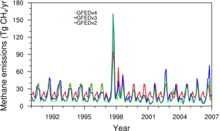
sim-Figure 2.Comparison of the interannual variation in methane
emis-sions from fire in the GFED v2 (van der Werf et al., 1996), GFED v3 (Gilglio et al., 2010), and GFED v4 (van der Werf et al., 2010). These data sets are obtained from http://www.globalfiredata.org/.
ulations (Patra et al., 2011). The methane emissions in the TransCom are specified and included the seasonal variation of methane emissions from anthropogenic sources (Olivier and Berdowski, 2001), rice paddies and wetlands (Ito and Inatomi, 2012), biomass burning (van der Werf et al., 2006), and termites (Fung et al., 1991). The wetland emissions from Ito and Inatomi (2012) are calculated based on a process-based terrestrial ecosystem model, the Vegetation Integra-tive Simulator for Trace gases (VISIT). In the VISIT, the in-undated area is calculated based on model-derived rainfall and temperature (Mitchell and Jones, 2005). We select this scenario from the TransCom experiment because it includes the long-term monthly variations of wetland and rice paddy emissions.
Differences between the TransCom simulation and the other three simulations analyzed here (see Table 1) include (1) differences in the specification of the methane emissions from rice paddies and wetlands: in the TransCom simulation the emissions are specified while in the remaining three sim-ulations the methane emissions are obtained from CLM4Me′
a process-based methane biogeochemical model; (2) differ-ences in the specification of fire emissions: in the TransCom simulation, fire emissions are taken from the Global Fire Emission Database (GFED) v2 (on average 20 Tg CH4yr−1 is emitted) (van der Werf et al., 2006) while in the remaining three simulations, the fire emissions are from GFED v3 (on average 21.1 Tg CH4yr−1 is emitted) (Giglio et al., 2010). The current version, GFED v4, has an average CH4 emis-sion of 15.7 Tg CH4yr−1(van Der Werf et al., 2010) which is much lower than GFED version 2 and version 3 (Fig. 2). Please note that GFED version 4 was not used in this study.
Two of the configurations analyzed (labeled CN_a and CN_b) diagnose wetlands and rice paddies methane emis-sions using CLM4Me′ within the Community Land Model
Table 1.Comparison of the methane sources in the four simulations used in this study.
Input Data TransCom CN_a CN_b BGC
Anthropogenic emissions OB20011 0.72·OB2001 OB2001 OB2001
Wetland emissions Ito and Inatomi (2012)5 CLM4.02 0.64·CLM4.02 0.74·CLM4.53
Rice paddy emissions Ito and Inatomi (2012) CLM4.0 CLM4.0 CLM4.5
Termite emissions Fung et al. (1991) Fung et al. (1991) Fung et al. (1991) Fung et al. (1991)
Fire emissions GFED v24 GFED v3 GFED v3 GFED v3
1OB2001 refers to the anthropogenic methane emissions in Olivier and Berdowski (2001). The average annual CH
4emissions are∼294 Tg yr−1over
the period of 1993–2004.2CLM4.0 refers to the methane emissions estimate in the CLM4.0 model as used in Meng et al. (2012). The average annual
methane emissions were∼228 Tg yr−1.3CLM4.5 refers to the methane emissions estimated in the CLM4.5 model. The estimated annual methane
emissions from CLM4.5 were∼190 Tg yr−1over the period of 1993–2004.4GFED indicates the Global Fire Emission Database. Average annual CH 4
emissions from GFED v2 and v3 are∼20 and∼21 Tg yr−1, respectively.5Wetland and rice paddy emissions from Ito and Inatomi (2012) were
downscaled to approximately 183 Tg yr−1over the period of 1993–2004 for TransCom. CLM4.0 rice paddy emissions are 37 Tg yr−1. CLM4.5 rice paddy
emissions are 42 Tg yr−1. Termite emissions from Fung et al. (1991) are 20 Tg yr−1. Note that the global total averaged emissions for the study period
used in the TransCom, CN_a, and CN_b, BGC are the same (within 1 % variation), but the spatial distribution of methane emissions might be different.
Figure 3.The interannual anthropogenic methane emissions over
the globe, in the tropics, mid-latitudes, and high latitudes. These data sets are obtained from TransCom (Patra et al., 2010)
CLM4Me′within the Community Land Model version 4.5
(CLM4.5 or CLM–BGC) of the CESM.
The wetland emissions simulated by CLM4Me′ model
when integrated in CLM4.0 (228 Tg yr−1) are on the high side of current estimates (100–284 Tg yr−1) (Denman et al., 2007; Kirschke et al., 2013). In order to obtain a reason-able overall methane budget (∼517 Tg yr−1, within the range of 492–581 Tg yr−1 shown in Denman et al. (2014) and Kirschke et al. (2013)), we adjust the emissions in the simula-tions using CLM4.0. In simulation CN_a, the anthropogenic emissions used in the TransCom simulations are multiplied by 0.72; in simulation CN_b the wetland emissions are mul-tiplied by 0.64, but the anthropogenic emissions are the same as those in TransCom. Both these re-scalings retain the tem-poral and spatial emission distributions from the original data sets but simulate the approximately correct atmospheric methane concentrations. In the first case (CN_a), where an-thropogenic emissions are reduced, the total anan-thropogenic emissions are 211 Tg yr−1. This is at the low end of estimated
anthropogenic emissions, but within the range (209–273 Tg) of values reported in the literature (see IPCC AR4 Chapter 7) (Denman et al., 2007; Kirschke et al., 2013) when excluding biomass burning and rice paddies.
On the other hand, the wetland emissions simulated by CLM4Me′model integrated into CLM4.5 (BGC) are higher
than CLM4.0 (CN) emissions. Therefore, we adjust the wet-land emissions in the BGC simulation. In particular, in the BGC simulation the wetland emissions are reduced by 26% to match the total methane emissions in the other simulations. Reducing the methane emissions is equivalent to modifying the coefficient for the maximum amount of methane that can be produced from heterotrophic respiration. The reductions used here are within the uncertainties of this estimate (e.g., Riley et al., 2011). The same termite emissions are used in all simulations. The global interannual average of methane emissions used in CN_a, CN_b, and BGC are similar to that used in TransCom.
2.2 CLM4Me′
CLM4Me′ (Meng et al., 2012) is a process-based methane
biogeochemical model incorporated in CLM version 4 and CLM version 4.5 of the Community Earth System Model (CESM). The spatial resolution used in this study is 1.8×2.5 degree. CLM4Me′is based on CLM4Me (Riley et al., 2011)
and explicitly calculates methane production, methane oxi-dation, methane ebullition, methane diffusion through soils, and methane transport through aerenchyma. CLM4Me′ is
an update of CLM4Me to include pH and redox func-tional dependence for methane emissions, and a limita-tion of aerenchyma in plants in always-inundated areas (Meng et al., 2012). In CLM4Me′, methane production
(P (mol C m−2s−1))is calculated as follows:
Figure 4.The difference in total emissions used in CN_a, CN_b, BGC experiments as compared with TransCom. A 12-month smoothed average is also plotted for the difference of CN_a (CN_a – TransCom), CN_b (CN_b – TransCom), BGC (BGC – TransCom) with TransCom. Please note that the average of the difference in the period of 1993–2004 is zero.
Figure 5.Temporal variation of wetland CH4fluxes estimated in
CN_a (green) and BGC (blue). The globe is divided into three re-gions: the tropics (30◦S to 20◦N), mid-latitudes (20–50◦N), and high latitudes (> 50◦N). Please note that this is the original methane emissions produced by CN_a and BGC without any multiplication. The smooth green and blue lines indicate the 12-month average wet-land CH4fluxes for CN_a and BGC.
Here,RH is heterotrophic respiration from soil and litter (mol C m−2s−1),f
CH4 is the ratio between CO2 and CH4
production, which is currently set to 0.2 for wetlands and rice paddies. Q′
10 is the control of soil temperature on CH4 production. fpH andfpE are pH and redox potential func-tion, respectively. A detailed description of CLM4Me and CLM4Me′ can be found in Meng et al. (2012) and Riley et
al. (2011).
2.3 Community Land Model (CLM)
CLM4Me′is integrated and spun up in two versions of CLM:
CLM4.0 and CLM4.5. CLM4.0 uses the carbon and nitro-gen belowground module from the Carbon-Nitronitro-gen (CN) model (Thornton et al., 2007, 2009). CLM4.5 is updated from CLM4.0 and offers some improvements, with the most significant change to the belowground carbon cycle (Koven et al., 2013). CLM4.5 includes an alternate decomposition cascade from the Century soil model, which is referred to as the biogeochemistry version of the model (CLM4.5–BGC). This version of the model has increased productivity and car-bon at high latitudes (perhaps an overestimate) and reduced productivity in the tropics compared to the CN model (see Koven et al. (2013) for more comparisons). The initial con-dition in both CLM models is created using NCEP reanal-ysis data sets in two steps. First the model is brought close to equilibrium for 1850 conditions (atmospheric CO2 con-centration, aerosol deposition, nitrogen deposition, and land use change) cycling a 25-year (1948–1972) subset of tran-sient climate data (1948–2004). Then we use these equili-brated conditions in a transient simulation from 1850 to 1990 (where the meteorology is cycled over the period of 1948– 2004) to produce the initial condition used in this study. For the period of this study (1990–2005), CLM4Me′ is forced
with multi-satellite-derived inundation fraction (Prigent et al., 2007) and NCEP (i.e., the National Center for Environ-mental Prediction) reanalysis data sets (Qian et al., 2006; Kistler et al., 2001). While the simulation period is 1990– 2005, satellite-derived inundation data is only available from 1993 to 2004. We use climatological monthly average (1993– 2004) inundation fraction for years 1990–1992 and 2005.
2.4 CAM-chem
We use CAM-chem (Lamarque et al., 2012), driven by the NCEP reanalysis data set (Kistler et al., 2001; Qian et al., 2006) to predict the atmospheric concentrations of methane from the methane emissions. In this study, we conduct sim-ulations with CAM-chem using offline meteorological forc-ing, similar to the model setup used in TransCom (Patra et al., 2011). The simulations are performed at a horizontal resolu-tion of 1.9◦(latitude) and 2.5◦(longitude) and at 28 vertical
layers. Please refer to Lamarque et al. (2012) for a detailed description of CAM-chem.
A) CN_a
B) BGC
Figure 6.The spatial difference in CH
4fluxes between four high
and low emission years. Please note CH4 fluxes are plotted on a
logarithmic color scale in CN_a (top,a) and BGC (bottom,b). The latitudinal average CH4flux is plotted on the right.
where an equal OH abundance is assumed in both the North-ern and SouthNorth-ern hemispheres. The distribution of OH used to compute the loss of atmospheric methane is identical to that used in TransCom experiments. Stratospheric loss due to Cl and O1D is also included. Interannually constant monthly Cl and O1D are used in the simulations. In addition, a soil sink for CH4is included using a climatological monthly av-erage derived from LMDZ (Laboratoire de Météorologie Dy-namique Zoom) atmospheric CH4inversion (Bousquet et al., 2006).
Atmospheric concentrations of methane are tagged from rice paddy, wetland, anthropogenic, and biomass burning emission sources. The losses of tagged methane are identi-cal to those described above.
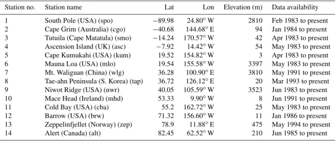
2.5 Observed atmospheric CH4concentration.
Observational atmospheric CH4 concentration data sets are obtained from the World Data Centre for Greenhouse Gases (WDCGG) at http://ds.data.jma.go.jp/gmd/wdcgg/. Monthly concentration data sets from 14 stations (Table 2) around the world are compared with the simulated atmospheric CH4 (Butler et al., 2004; Cunnold et al., 2002). Most of the sites have monthly or weekly measurements and use
A) CN_a
B) BGC
Figure 7. Zonal average monthly methane fluxes with time in
CN_a (top,a) and BGC (bottom,b) experiments.
the flask-sampling method. Collected samples are analyzed using gas chromatography with flame ionization detection (Dlugokencky et al., 2005).
2.6 RMS Variability
Table 2.A list of stations used in this study.
Station no. Station name Lat Lon Elevation (m) Data availability
1 South Pole (USA) (spo) −89.98 24.80◦W 2810 Feb 1983 to present
2 Cape Grim (Australia) (cgo) −40.68 144.68◦E 94 Jan 1984 to present
3 Tutuila (Cape Matatula) (smo) −14.24 170.57◦W 42 Apr 1983 to present
4 Ascension Island (UK) (asc) −7.92 14.42◦W 54 May 1983 to present
5 Cape Kumukahi (USA) (kum) 19.52 154.82◦W 3 Apr 1983 to present
6 Mauna Loa (USA) (mlo) 19.54 155.58◦W 3397 May 1983 to present
7 Mt. Waliguan (China) (wlg) 36.28 100.90◦E 3810 May 1991 to present
8 Tae-ahn Peninsula (S. Korea) (tap) 36.72 126.12◦E 20 Mar 1993 to present
9 Niwot Ridge (USA) (nwr) 40.05 105.59◦W 3523 Jun 1983 to present
10 Mace Head (Ireland) (mhd) 53.33 9.90◦W 8 Jun 1991 to present
11 Cold Bay (USA) (cba) 55.2 162.72◦W 25 May 1983 to present
12 Barrow (USA) (brw) 71.32 156.60◦W 11 Jan 1986 to present
13 Zeppelinfjellet (Norway) (zep) 78.9 11.88◦E 475 May 1994 to present
14 Alert (Canada) (alt) 82.45 62.52◦W 210 Jun 1985 to present
often greater than 1 in cases of cancelation of signals among individual sources.
2.7 Taylor diagrams
Taylor diagrams can provide a concise statistical summary of model performance in a single polar coordinate plot (Taylor, 2001). In this study, we use Taylor diagrams to evaluate the model’s ability to simulate the observed interannual variabil-ity (IAV) of atmospheric CH4. The Taylor diagram gives the model–measurement coefficient R reflecting the agreement in shape and phasing of the model and measurement time series and the ratio of modeled to measured standard devi-ationσmodel/ σobs, which represents the agreement between the amplitude of the simulated and observed interannual vari-ability (IAV) of atmospheric CH4.
3 Results and discussions
3.1 Comparison of methane fluxes from different
sources
A comparison of methane fluxes used in the four experiments shows that wetlands and rice paddies methane emissions in CN_a are higher than those used in other three simulations (Fig. 1). Emissions from wetlands and rice paddies in the CN_b (i.e., the CN_a wetland emissions reduced by 36 %) simulations are comparable with those used in TransCom and BGC experiments (Fig. 1). There are different magni-tudes in the seasonal and interannual variations among these four experiments. Overall, BGC has the lowest winter emis-sions. There is a decreasing trend in the CN_a and CN_b methane emissions not evident in the TransCom and BGC methane emissions. The difference in methane emissions in CN_a, CN_b, and BGC experiments will be discussed in the next session. The fire emissions in the TransCom simulation
(based on GFED v2) and the other simulations (based on GFED v3) (Fig. 2) are similar in magnitude, but with some distinct seasonal differences.
Overall, the anthropogenic methane emissions tend to sta-bilize after 1998, due to the decrease from mid- and high lat-itudes (Fig. 3). The annual total methane emissions used in CN_a and CN_b experiments are slightly higher (lower) than that used in TransCom experiment during the first (second) half of the study period (Fig. 4). The annual total emissions used in BGC are slightly lower than those used in TransCom during most years except 1997, 1998, and 2002. There are no statistically significant trends (at∼95 % level) in the
differ-ence between the BGC and TransCom total emissions.
3.2 Seasonal and interannual variability in CN_a and BGC methane emissions
3.2.1 CN_a methane emissions
There are strong seasonal and interannual variations in CN_a wetland methane emissions (Fig. 5). On a seasonal basis, the peak methane emissions occur in the summer (June, July, and August) and the lowest methane emissions occur in winter (December, January, and February) as methane emissions are controlled by both temperatures and inundated area. On an interannual basis, the summer of 1994 has the highest CN_a methane emissions methane emissions in the period of 1993– 2004. A generally decreasing trend (−2.1 Tg CH4yr−1, sig-nificant at 95 % level) in CN_a global wetland emissions occur from 1994 to 2004. This is driven by trends in tropi-cal wetland emissions (Fig. 5), where tropitropi-cal wetlands con-tribute to∼70 % of the global wetland flux. The
decreas-ing rate in tropical wetland emissions from 1993 to 2004 is approximately−1.68 Tg CH4yr−1, statistically significantly different from 0 (no change) at the 95 % confidence level.
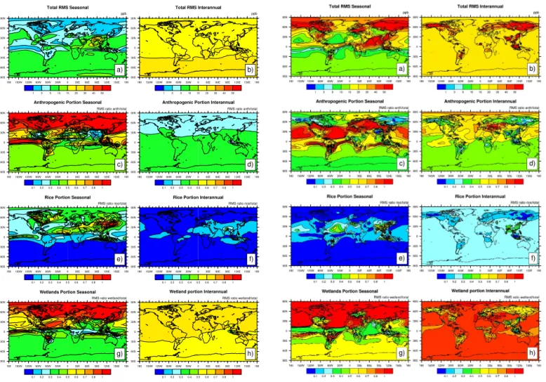
Figure 8. RMS variability (in ppb) from 1993 to 2004 of atmo-spheric CH4 concentration in CN_a experiment. The left panel
shows seasonal RMS variability and the right panel indicates inter-annual RMS variability. From the top to the bottom are total RMS variability(a, b), anthropogenic contribution to total RMS variabil-ity(c, d), rice contribution to total RMS variability(e, f), and wet-land contribution to RMS variability(g, h). Note that proportional RMS variability of anthropogenic sources, rice paddies, and wet-lands add up to > 1 when cancellation among component tracers occurs in the summing of total CH4.
methane emissions in the period of 1993–2004 and plot the difference of methane emissions between the average of these four extreme high and low emission years (Fig. 6a). There are large differences across much of the globe, but the largest difference occurs in the tropics (see the latitudi-nal average on the right side of Fig. 6a). On a regiolatitudi-nal level, the largest differences are primarily present in Indonesia and South America (e.g., the Amazon regions).
3.2.2 BGC methane emissions
The trend in BGC wetland methane emissions is different from that in CN_a experiment (Fig. 5). In the BGC simula-tion, the peak emissions occur in 2002 instead of 1994. The
Figure 9. RMS variability (in ppb) from 1993 to 2004 of
at-mospheric CH4concentration in BGC experiment. The left panel
shows seasonal RMS variability and the right panel indicates inter-annual RMS variability. From the top to the bottom are total RMS variability(a, b), anthropogenic contribution to total RMS variabil-ity(c, d), rice contribution to total RMS variability(e, f), and wet-land contribution to RMS variability(g, h). Note that the portions of RMS variability of anthropogenic sources, rice paddies, and wet-lands add up to > 1 when cancellation among component tracers occurs in the summing of total CH4.
wetland emissions do not decrease significantly from 1993 to 2004 with no significant trends in the interannual methane emissions in the mid- and high latitudes and the tropics in these simulations. There are several additional differ-ences between CN_a and BGC wetland emissions: (1) global BGC wetland emissions are approximately 10 % lower than CN_a wetland emissions; (2) the BGC tropical (−30◦S to
20◦N) wetland emissions of 63 Tg CH
4yr−1 are approxi-mately 60 % lower than those in CN_a (158 Tg CH4yr−1); (3) high-latitude (> 50◦N) wetland emissions in BGC are
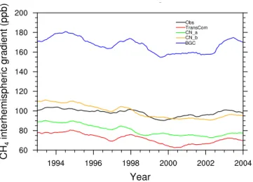
Figure 10. The interhemispheric gradients (N–S) in atmospheric CH4concentration. The N–S gradients are calculated as the
differ-ence in atmospheric CH4concentration in Northern and Southern
hemispheres at these stations listed in Table 1. The observational CH4concentration data set at these stations is from the World Data
Centre for Greenhouse Gases (WDCGG) at http://ds.data.jma.go.jp/ gmd/wdcgg/.
et al., 2013). BGC and CN_a produce similar methane emis-sions in the mid-latitudes (20–50◦N).
The latitudinal distribution of the methane emissions in CN_a suggests the largest seasonal variation occurs at ap-proximately 20–30◦N, followed by the latitudinal band 50–
60◦N (Fig. 7a). High latitudes (> 65◦N) have no clear
sea-sonal cycles due to the low methane fluxes that CN_a pro-duces in the high latitudes (Meng et al., 2012). There is a very dampened seasonal variation of CH4emissions in tropi-cal wetlands (10◦S to 10◦N), although tropical wetlands are
the largest contribution to total wetland emissions. The sea-sonal cycle in the different latitudinal bands is consistent with that identified in Spahni et al. (2011) (see their Fig. 4a).
The latitudinal distribution of methane emissions shows a strong seasonal variation at high latitudes in the BGC sim-ulation. As clearly shown in Fig. 7b, peak methane emis-sions (> 200 mg CH4m−2d−1) occur in summer seasons and low methane emissions (∼10 mg CH4m−2d−1) are present in winter. The maximum emissions occur at approximately 60◦N as distinct from the CN_a simulations.
The peak emissions in BGC from 1993 to 2004 occur in 1998 followed by 2002, 1994, and 2003. The four lowest emission years are 1999, 2000, 2001, and 1996. As shown in Fig. 6b, the increase in methane emissions from the four low-est to highlow-est years is primarily on the equator, in the South-ern Hemisphere (around 30◦S) and in the high latitudes (50–
70◦N). This is distinct from the CN_a simulations, where the
largest change predominantly occurs in the tropics (Fig. 6a).
3.2.3 Sources of the differences in CLM4.0- and CLM4.5-estimated methane emissions
The large difference in spatial distribution of methane emis-sions between CN_a (CLM4.0) and BGC (CLM4.5) exper-iment is due to the change in soil biogeochemistry within the soil C and N models from CLM4.0 to CLM4.5. Koven et al. (2013) conduct a detailed analysis of the effect of such changes on C dynamics in the CLM model. Here, we briefly describe the changes that most affect high-latitude and trop-ical C dynamics, where the differences are the largest. The carbon cycle is linked to the nitrogen (N) cycle because N availability in soils will affect vegetation growth. In CLM4.0, available mineral N experiences a first-order decay with a time constant of 2 days that is not subject to environmen-tal limitations. At high latitudes, the long winters allow most mineral N to decay and only a limited amount of N is avail-able for vegetative growth during the short growing season. Therefore, in the high latitudes, CLM4.0 simulates low pro-ductivity and low heterotrophic respiration (HR) available for methane production (in CLM4Me, methane production is a function of heterotrophic respiration, see methane produc-tion equaproduc-tion in Sect. 2.1). In CLM4.5, an introducproduc-tion of the dependence of N losses on temperature and soil mois-ture and seasonality of N fixation reduce the unrealistic N limitation in CLM4.0. Thus, CLM4.5 allows for more N to be used for vegetation growth and produces higher soil car-bon, higher heterotrophic respiration (HR), and thus higher methane fluxes. As shown in Appendix Fig. A1, HR in CLM4.5 is much higher than that in CLM4.0, particularly in the Northern Hemisphere summer season when most CH4is produced. Please note that annual CH4emissions from north-ern latitudes are not affected by winter time HR because CH4 is not produced in winter seasons due to below-freezing tem-peratures.
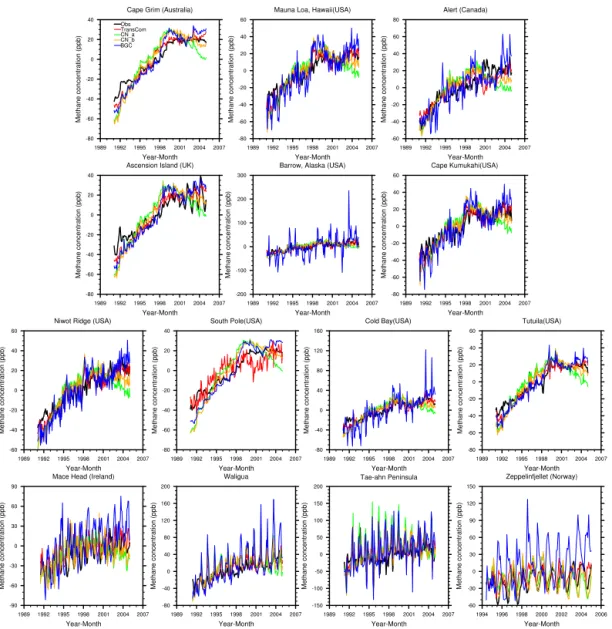
Figure 11.The comparison of model-simulated atmospheric CH4concentration at the closest grid box vs. observations. The climatological
monthly mean is removed to focus on interannual variability in atmospheric CH4concentration at these stations. Model simulations are obtained from TransCom, CN_a, CN_b, and BGC experiments. The observational CH4concentration data set at these stations is from the
World Data Centre for Greenhouse Gases (WDCGG) at http://ds.data.jma.go.jp/gmd/wdcgg/.
3.3 Contribution of individual sources to seasonal and interannual variability in atmospheric CH4
In order to determine the relative contribution of each source to total atmospheric CH4variability as simulated in CAM-chem, we calculate the seasonal and interannual root mean square (RMS) variability for the total CH4concentration and the relative contribution of the anthropogenic source, rice paddies, and wetlands to the overall RMS (Figs. 8 and 9). These three sources have the largest contribution to the an-nual RMS due to their large magnitudes.
3.3.1 Seasonal and interannual variability in CN_a methane emissions
Seasonal variability of atmospheric methane concentrations is high in the tropics and Southern Hemisphere and low in the northern high latitudes in the CN_a simulations (Fig. 8). The low seasonal variability in the northern high latitudes is consistent with the relatively low magnitude of northern high-latitude methane fluxes in the CN_a simulations, plus the fact that the highest emissions occur during the summer, when the vertical mixing is highest.
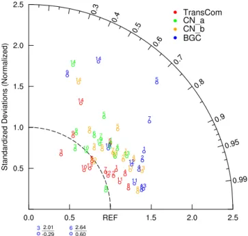
Figure 12.Taylor diagrams comparing the model interannual vari-ability to methane observations at 14 stations. In this Taylor dia-gram, the angle from the x axis is the correlation coefficient be-tween model and observed time series of atmospheric CH4
concen-tration. The value on the radial axis is the standard deviation ratio:
σmodel/ σobs. It represents the match between the amplitude of the
model and observed interannual variability. Please refer to Table 2 for the stations associated with each number.
0 0.1 0.2 0.3 0.4 0.5 0.6 0.7 0.8 0.9 1
1 2 3 4 5 6 7 8 9 10 11 12 13 14
C
or
r
e
lati
on
Station
TransCom
CN_a
CN_b
BGC
Figure 13.Comparison of correlations between TransCom, CN_a,
CN_b, BGC, and observations (same as in Fig. 12). The station numbers correspond to those in Table 2.
atmospheric methane is generally larger than the seasonal RMS. Anthropogenic sources and wetlands are the dominant contributors to the seasonal RMS variability in the North-ern Hemisphere (Fig. 8), while wetlands are the only domi-nant contributor to the IAV RMS variability. This is in agree-ment with Bousquet et al. (2006), who reported that wetland emissions dominate the interannual variability of methane
sources. Rice paddies play a more important role in seasonal RMS variability than in interannual RMS variability over Asia and North America. This is consistent with the largest seasonal variations in rice paddy emissions occur over Asia and North America (Meng et al., 2012). Similar results are also found in CN_b simulations.
3.3.2 Seasonal and interannual variability in BGC methane emissions
Compared to CN_a, the BGC methane emissions show higher seasonal and interannual variability, particularly at high latitudes (Fig. 9). For instance, Alaska and Siberia have the highest variability. For both the seasonal and interannual variations, wetlands dominate the variability, followed by an-thropogenic sources. Rice paddies only play a role in the tropics (0–30◦N). Both wetlands and anthropogenic methane
emissions in BGC contribute a higher percentage to the inter-annual variations than in the CN_a simulations.
3.4 Interhemispheric gradients in atmospheric CH4
concentrations
The latitudinal gradient from TransCom, CN_a, CN_b, BGC, and observations is shown in Fig. 10. The latitudinal gradi-ent is defined as the difference in averaged CH4 concentra-tion between the Northern and Southern hemispheres (N–S gradients); stations listed in Table 2. The N–S gradients pro-duced in all four simulations are highly correlated with ob-servations for the period of 1993–2004 (Fig. 10). The cor-relations (r) are 0.83, 0.72, 0.76, and 0.91 (all four correla-tions are significant at 95 % confidence level) for TransCom, CN_a, CN_b, and BGC, respectively. It is also clearly shown in Fig. 10 that the TransCom and CN_a simulations under-estimate the N–S hemisphere gradients. The underestimation of N–S gradients in CN_a might be due to the high tropical wetland emissions in this case as the high tropical emissions are likely to increase the CH4 concentration in the South-ern Hemisphere. The BGC simulation significantly overes-timates the N–S hemisphere gradients, by about 70 %, con-sistent with the large high-latitude methane emissions in this simulation and the low tropical emissions. The CN_b simu-lation, with the same anthropogenic emissions as TransCom, but decreased wetland methane emissions, compared with CN_a, best reproduces the observed N–S gradient during the period of 1993–2004. The N–S gradients decrease be-tween 1993 and 2004 in TransCom, CN_a, and CN_b ex-periments, although there is only slight decrease in the mea-surements (Fig. 10). Dlugokencky et al. (2011) calculate the inter-polar difference (IPD) (difference between the northern (53–90◦N) and southern (53–90◦S) annual mean CH
Figure 14.Atmospheric CH4growth rate as a function of latitude in
observations, TransCom, CN_a, CN_b, and BGC simulations. 90 % confidence intervals are also shown.
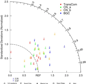
Figure 15. Taylor diagram comparing model N–S gradients (no.
1), annual growth rates (no. 2), and interannual variability (no. 3) with observations for the South Pole, Mauna Loa, Niwot Ridge, and Alert (Canada) stations, respectively for the four simulations. The four stations are selected to represent the South Pole, tropics, mid-latitudes, and high latitudes. The annual growth rate is calcu-lated as the difference between the mean methane concentrations of the current year and the previous year. The N–S gradients are from Fig. 10.
3.5 Evaluation of model interannual variability
Model simulation of the IAV of atmospheric CH4 concentra-tions is evaluated against site observaconcentra-tions over 14 staconcentra-tions (Table 1) around the world. The climatological seasonal cy-cle is removed in order to focus on the IAV. CN_a simulates
the trend in methane from 1993 to approximately 2001 at all of the stations, but tends to underestimate observations dur-ing the later period (2001–2004) (Fig. 11). Such an underes-timation might be due to the large decrease in CN_a simu-lated wetland emissions (Fig. 5). The CN_b simulation with decreased wetland emissions (CN_b in Fig. 11) shows in-creased atmospheric methane concentrations during the later period (2001–2004), allowing for a better match between ob-servations and model simulations. In the BGC simulation, model-simulated atmospheric concentrations are relatively flat from 1998 to 2004, which match the observations well (Fig. 11). In the TransCom experiment, simulated CH4 con-centration anomalies are generally in good agreement with observations at all of the stations.
The Taylor diagram of model–observation comparisons of interannual variability show that TransCom performed the best among the three cases while CN_b and BGC simula-tions performed slightly better than CN_a due to a better cor-relation with the measurements (Fig. 12). The performance of BGC simulations is comparable to (or slightly better than) TransCom in terms of the correlation (Fig. 13) although the model tends to overpredict the amplitude of the interannual variability. Decreasing wetland emissions (CN_b) allows for a better match between model simulations and observations. This suggests that CN_a simulations might overestimate wet-land emissions, which agrees with the findings in Kirschke et al. (2013).
3.6 Methane growth rate
The growth rate refers to the average increase in atmospheric CH4 concentration per year. We calculate the growth rate at each station from the observations and for each simula-tion. The observed average growth rate ranges from 3.2 to 4.6 ppb yr−1 with an average of 4.0 ppb yr−1 (Fig. 14, Ta-ble 3). The average growth rate in TransCom, CN_a, CN_b, and BGC experiments is 4.2, 3.29, 4.05, and 5.68 ppb yr−1, respectively (Table 3). The growth rate in TransCom, CN_a, CN_b, and BGC simulations has a large range (from−0.48 to 6.44 ppb yr−1) at all stations analyzed. As can be seen from Fig. 14, both CN_a and CN_b tend to underestimate the observed growth rate in the Northern Hemisphere, but overestimate it in the Southern Hemisphere (Fig. 14) except for the South Pole station. BGC tends to overestimate the growth rate in the Northern Hemisphere, particularly in the high latitudes (Fig. 14). TransCom gives better agreement with the measured growth rates in the Southern Hemisphere than in the Northern Hemisphere. The largest difference in the growth rate between the three cases and the observations occur at the Zeppelinfjellet (zep, Norway) where the average growth rate in TransCom, CN_a, CN_b, BGC, and observa-tions was−0.92,−0.48, 1.99, 4.2, and 3.4 ppb yr−1,
Overall, CN_a and CN_b underestimate the station growth rate at high latitudes while BGC overestimates it.
In addition, a summary of the comparison of model N– S gradients, annual growth rates, and interannual variability with observations is presented in Fig. 15. Four stations are specifically selected to represent the South Pole, tropical re-gions, mid-latitudes, and high northern latitudes. Root mean square errors and biases for the four simulations at these four stations are listed in Table 4. As seen in Fig. 15, and dis-cussed above, no one model simulation best matches all the observational metrics.
3.7 Comparison of interannual variability between this study and others
We also compare the interannual variability in CH4emission anomalies in the simulations analyzed here with those given in Spahni et al. (2011), in an updated long-term atmospheric synthesis inversion from Bousquet et al. (2006) and from Ringeval et al. (2010). (Fig. 16). As discussed above, the CN_a emissions reach their maximum in 1994 and decrease thereafter from 1994 to 2004 (Fig. 16). The BGC emissions have the highest emissions in 1998, the lowest emissions in 1999, and increased emissions from 1999 to 2004. The TransCom emissions increase from 1993 to 1998 and slightly decrease thereafter. The wetland emissions in Ringeval et al. (2010) decrease from 1993 to 2000. The Ringeval et al. (2010) averaged annual wetland methane emissions are
∼215 Tg yr−1, similar to the CN_a wetland emissions. How-ever, the atmospheric synthesis inversions of global wetland emissions (update of Bousquet et al., 2006 (constant OH)) in-crease from 1990 to 2000 followed by a dein-crease from 2000 to 2005. Thus, there seems to be little agreement in the inter-annual variability of the wetland methane emissions between these various simulations.
We further compare our model-derived wetland emis-sions with those from the Wetland and Wetland CH4 Inter-comparison of Models Project (WETCHIMP) (Melton et al., 2013; Wania et al., 2013). We conduct two different compar-isons: one includes all models with their different parameter-izations of wetland extent while the other focuses on models that are driven by satellite-derived inundation data sets (see Table 1, Melton et al., 2013).
Each model analyzed in Melton et al. (2013) uses a differ-ent wetland parameterization to estimate their wetland extdiffer-ent (see Table 1 in Melton et al. (2013) for details). Therefore, it is not surprising to see the large variation in wetland extent among these models from 1993 to 2004 (Fig. 17). Among the models analyzed in Melton et al. (2013), only the LPJ–WSL model uses prescribed monthly inundation data sets, similar to our simulations (Fig. 17). DLEM_norice prescribes max-imum extent at each grid cell from satellite-derived inunda-tion data sets but with simulated intra-annual dynamics. All simulations making use of the satellite measurements (this study, LPJ–WSL, BGC, and DLEM_norice) show a decrease
-40 -30 -20 -10 0 10 20 30 40 50
1993 1995 1997 1999 2001 2003 2005
M on th ly Emi ss ion A n omal ie
s (Tg C
H4
/yr
)
Year
TransCom LPJ variable source area
CN_a LPJ
CN_b update of Bousquet et al. 2006 (constant OH) BGC Ringeval et al. 2010
Figure 16. Comparison of the interannual variability in wetland
CH4 emissions used in this study and in others. A centered
12-month running mean filter has been applied to smooth 12-monthly output. Data for “LPJ variable source area”, “LPJ”, and “update of Bousquet et al. (2006) (constant OH)” are obtained from Spahni et al. (2011). “LPJ variable source area” indicates emissions anoma-lies for 1993–2000 calculated by using the observed monthly inun-dated area (Prigent et al., 2007). “LPJ” indicates global CH4 emis-sion anomalies simulated by LPJ (natural ecosystem and rice agri-culture) for scenario SC2 listed on Spahni et al. (2011). “update of Bousquet et al., 2006 (constant OH)” refers to global wetland emission anomalies derived from long-term atmospheric synthesis inversion updated from Bousquet et al. (2006). TransCom refers to emission anomalies derived from the combined wetland and rice paddy emissions. Methane emissions in Ringeval et al. (2010) are estimated using the ORCHIDEE global vegetation model with a process-based wetland CH4emission model. The wetland area is prescribed to the observed monthly inundated area (Prigent et al., 2007) in Ringeval et al. (2010). The mean anomalies over 1993– 2000 are adjusted to zero for the all data plotted on this graph.
Table 3. Comparison of the mean growth rate (ppb yr−1) of
at-mospheric methane concentration in each simulation with observa-tions.
Station Lat Obs TransCom CN_a CN_b BGC
spo −89.98 4.61 6.11 5.05 3.62 6.44
cgo −40.68 4.64 5.96 4.86 5.67 6.35
smo −14.24 4.44 5.34 4.21 5.09 5.87
asc −7.92 4.23 5.72 4.57 5.55 6.29
kum 19.52 3.75 4.21 3.37 4.12 5.46
mlo 19.53 3.95 4.37 3.46 4.28 5.59
wlg 36.28 4.39 4.3 3.27 4.37 6.34
tap 36.72 3.2 3.72 2.92 3.89 4.88
nwr 40.05 4.16 4.4 3.49 4.27 5.56
mhd 53.33 3.92 2.78 1.98 2.98 4.52
cba 55.20 3.77 3.97 3.31 3.81 6.2
brw 71.32 3.27 3.42 2.92 3.35 6.42
zep 78.90 3.42 0.92 −0.48 1.99 4.2
alt 82.45 4.6 3.67 3.08 3.65 5.47
Table 4.Model performance statistics including the root mean square error (RMSE) and bias (ppb yr−1). Bias is calculated as the absolute
deviation of the mean between model simulations and observations.
N–S gradients Growth rate Interannual variability
RMSE South Pole Mauna Loa Niwot Ridge Alert South Pole Mauna Loa Niwot Ridge Alert
TransCom 25.92 5.41 3.55 2.44 11.65 10.47 8.28 7.35 8.69
CN_a 17.57 0.57 4.22 2.88 5.13 12.65 13.96 14.59 15.06
CN_b 5.39 0.59 5.74 4.19 6.06 11.32 12.1 11.88 12.03
BGC 69.62 0.67 7.78 6.81 30.88 8.88 13.97 10.89 14.18
Bias South Pole Mauna Loa Niwot Ridge Alert South Pole Mauna Loa Niwot Ridge Alert
TransCom 0.26 0.58 0.3 0.22 −1.69 0.08 0.01 0.02 0.01
CN_a 0.17 0.03 0.05 0.29 −1.05 0.02 0.02 0.03 0.04
CN_b 0.02 0.07 0.06 0.34 −0.72 0.03 0.02 0.02 0.03
BGC 0.71 0.06 1.36 1.29 −3.13 0.01 0.02 0.02 0.04
in wetland extent from 1993 to 2004. The wetland extent anomalies in DLEM_norice simulations differ as the intra-annual dynamics are simulated (Fig. 17).
The models that do not use a prescribed satellite-derived inundation data set do not simulate notable decreases in wet-land extent during the period of 1993–2004 (Fig. 17). This is not in agreement with the satellite-derived inundation data set: Papa et al. (2010) find∼5.7 % decrease in mean annual
maximum inundation from 1993 to 2004 with a maximum decrease in the tropics (see Appendix). In fact, all models (excluding LPJ–WSL, DLEM_norice, and this study) show large increases in wetland extent in 1998 compared to 1997, which is also documented in Melton et al. (2013).
Melton et al. (2013) demonstrate that the difference in wet-land area used in different models might partially explain the discrepancy in model-estimated wetland emissions. As shown in Melton et al. (2013), model-derived methane emis-sions are strongly correlated with the wetland extent (with an average correlation of 0.90 on the global scale). All models that produce a peak methane emission in 1998 have a max-imum wetland extent at the same time (Fig. 18). The differ-ence in model-derived methane emissions can be attributed partially to the different wetland area used in each model, where the wetland extent is highly uncertain (Melton et al., 2013). However, it should be noted that there are several lim-itations associated with using wetland extent derived from satellite-derived inundation data sets. As suggested in Prigent et al. (2007), satellites might underestimate inundated areas due to their incapability to detect small water bodies. Fur-thermore, satellite data sets only include fully inundated ar-eas and excluded unsaturated wet mineral soils, which might also be an important wetland methane source (Spahni et al., 2011).
The methane emission anomalies in DLEM_norice and LPJ_WSL (the simulations in Melton et al. (2013) us-ing satellite-derived wetland extent) show similar tempo-ral variations, as do the methane anomalies in CN_a and
CN_b simulations (Fig. 18). Emissions estimated in CN_a, CN_b, DLEM_norice, and LPJ_WSL peak in 1993–1994 and showed a decrease afterwards. Such a decreasing trend is consistent with the decrease in wetland extent used in these models (Fig. 17). The CN_a and CN_b simulations show a large increase in emissions from 1993 to 1994, but do not simulate large increases in methane emissions from 2001 to 2002 even though wetland extent increases during this pe-riod. It should be noted that the BGC simulation uses the same wetland extent as CN_a and CN_b but does not give the same large decrease in the emissions during the period of 1993–2004. In fact, the BGC model gives decreasing emis-sions from 1993 to 1994 but increasing methane emisemis-sions from 2001 to 2002. The BGC model also shows that the high-est emission occurs in 1998 and the lowhigh-est in 1999 during the period of 1993–2004.
sim--1500 -1000 -500 0 500 1000 1500
1993 1995 1997 1999 2001 2003
W etl an d A re a (10 3km 2) Year SDGVM LPJ-WSL ORCHIDEE LPJ-Bern_norice DLEM_norice CLM4Me This study
Figure 17.12-month smoothed average of the anomalies in
wet-land areal extent used in the models that participate in WETCHIMP project (Melton et al., 2013; Wania et al., 2013) and in this study (satellite-derived inundated area obtained from Prigent et al. (2007) and Papa et al., 2010). LPJ–Bern_norice and DLEM_norice are LPJ–Bern and DLEM models that do not include rice paddy sim-ulations, respectively. These notifications indicate WETCHIMP project also produce simulations with rice and only no rice sim-ulations are included in this comparison study. In this figure, the long-term mean (1993–2004) is removed from each data set.
-40 -30 -20 -10 0 10 20 30 40 50
1993 1995 1997 1999 2001 2003 2005
M eth an e Emi ss ion A n omal
y (Tg C
H4
/yr
)
Year
BGC SDGVM
CN_b LPJ-WSL
CN_a ORCHIDEE
TransCom LPJ-Bern_norice
DLEM_norice CLM4Me
Figure 18. Similar to Fig. 16, but showing the models that
par-ticipate in WETCHIMP (Melton et al., 2013; Wania et al., 2013). Each model uses a different wetland extent to estimate methane emissions (see Table 1 in Melton et al. (2013) for wetland deter-mination scheme in each model). LPJ–WSL prescribes the wetland area from a monthly inundation data set (Prigent et al., 2007, Papa et al., 2010). DLEM_norice prescribes the maximum wetland area from the inundation data set with simulated intra-annual dynam-ics. Sheffield Dynamic Global Vegetation Model (SDVGM) uses the internal hydrological model to determine wetland locations. All other models parameterize wetland areas based on an inundation data set or a land cover data set, which produce different interan-nual and intra-aninteran-nual variability in wetland areas. Please also refer to Melton et al. (2013) for a detailed description of each model (SD-VGM, LPJ–WSL, ORCHIDEE, LPJ–Bern_norice, DLEM_norice, CLM4Me). -5 -4 -3 -2 -1 0 1 2 3 4
1993 1995 1997 1999 2001 2003 2005
H R /N P P (P g C /yr ) Year
NPP in CN_a NPP in BGC
HR in CN_a
HR in BGC
Obs
Figure 19.Temporal variation of the anomalies in globally averaged
heterotrophic respiration (HR) and net primary production (NPP) in CN_a and BGC experiments. Blue dots indicate globally aver-aged NPP anomalies from satellites obtained from Zhao and Run-ning (2010). A 12-month smoothing is applied to monthly anoma-lies in HR and NPP.
ulated global wetland emissions are also highly correlated with HR (0.89) and with wetland extent (0.81). Such high correlations suggest that both HR and wetland extent are dominate drivers of wetland methane emissions in the CN_a and BGC models. Thus, although the BGC experiment uses the same satellite-derived inundated area in CN_a, it does not produce a decreasing trend in methane emissions during the period, probably due to its different trend in HR estimated in BGC as compared with that in CN_a (Fig. 19).
4 Conclusions
In this study, we evaluate the temporal and spatial pat-terns in wetland methane emissions simulated in CLM4Me′
from two different parameterizations of soil carbon–nitrogen dynamics as included in CLM4.0 (CN_a and CN_b) and CLM4.5 (BGC). The subsequent methane distributions are simulated in CAM-chem using meteorological drivers con-sistent with those used to drive the CN and BGC models. Our goals for this study are (i) to evaluate the wetland methane fluxes simulated in the two versions of CLM so as determine the sensitivity of methane emissions to the underlying carbon model; (ii) to compare the simulated atmospheric methane concentrations to atmospheric measurements, including lat-itudinal gradients and interannual variability, so as to de-termine the extent to which the atmospheric observations constrain the emissions; (iii) to understand the drivers of seasonal and interannual variability in atmospheric methane fluxes.
sensitiv-ity in the simulation of wetland emissions to the underlying model. Compared to the CN_a simulations, the BGC simu-lations produce large emissions (∼97 Tg yr−1on average) in
the northern high latitudes (50–90◦N) with very strong
sea-sonal variations (from no emissions in NH winter to more than 300 Tg yr−1in NH summer) and relatively small wet-land emissions (only∼30 % of global emissions) in the
trop-ical region. On the other hand, the CN_a simulation has very large tropical emissions (∼70 % of global wetland sions) so that changes in the tropics dominate global emis-sions.
The large difference in their high-latitude emissions can be ascribed to the different simulation of nitrogen dynamics in the CN and BGC simulations. In CLM4.0, available min-eral N experiences a first-order decay with a time constant of 2 days, which is not subject to environmental limitations, while in the BGC simulation the an introduction of the de-pendence of N losses on temperature and soil moisture and the seasonality of N fixation reduce the unrealistic N loss in CLM4.0. The larger nitrogen availability in the BGC model at high latitudes allows greater carbon pools to develop, thus increasing the heterotrophic respiration at high latitudes. The large difference in tropical wetland emissions between the BGC and CN_a experiments is possibly due to the changes in decomposition rates, carbon vertical mixing, and the re-lease of nitrogen limitation from the CN_a to the BGC model (Koven et al., 2013). Overall, these changes reduce NPP and HR in the tropics, which directly impacts the methane fluxes. Both the CN and BGC simulations also differ in the rela-tive magnitude of seasonal vs. interannual variability (IAV) of atmospheric methane concentrations for the period of 1993–2004. IAV is relatively higher (average total RMS is approximately 20 ppb) than the seasonal variability (approx-imately 10 ppb) across the globe in CN_a (Fig. 8), while in BGC, IAV is much higher (∼25 ppb) than the seasonal
vari-ability (∼10 ppb) except for the northern latitudes (> 50◦N)
(Fig. 9). Anthropogenic sources and wetlands contribute sig-nificantly to seasonal variations of atmospheric methane con-centrations in CN_a and BGC. Wetland emissions dominate global interannual variability when CAM-chem is forced with either the CN_a or BGC methane emissions, in agree-ment with findings in Bousquet et al. (2006).
There are also substantial differences in the interannual variability between the two model versions. CN_a wet-land emissions suggest a decreasing trend from 1994 to 2004, which is similar to those estimates from Ringeval et al. (2010) and DLEM_norice and LPJ–WSL models (Melton et al., 2013; Wania et al., 2013). On the other hand, CLM4Me′methane emissions driven by CLM4.5 (the BGC
simulation) are highest in 1999 and do not show significant decrease during the period. The updated estimate from Bous-quet et al. (2006) gives increasing emissions from 1991 to 2000 and a decrease after 2000. A few participating wet-land emission models in the WETCHIMP project also predict
peak methane emissions in the middle of the period (around 1998–1999).
The methane emissions in all simulations conducted here are input into CAM-chem so as to constrain the resulting at-mospheric methane concentrations against atat-mospheric mea-surements. The meteorological fields driving atmospheric and land models are consistent. In particular, we compare the simulations against measured the interhemispheric gra-dient, interannual variability, and growth rate. Our results show that CN_b simulations (with reduced CN_a wetland emissions) are able to better produce observed atmospheric methane concentrations and the observed N–S gradient in methane concentrations, suggesting that CN_a might over-estimate the current wetland emissions. In the BGC exper-iment, modeled atmospheric interannual variability in con-centrations has higher correlations with observations than the CN_a and CN_b simulations in the majority of stations (Fig. 13). In the TransCom experiment, the magnitude of the correlation between modeled atmospheric concentrations and observations is similar to that of the BGC experiment. We also find that CN_b experiments tend to underestimate the growth rate and BGC overestimates it at high latitudes. TransCom simulations have an overall better estimation of the growth rate at all stations than the other three simula-tions. In terms of the N–S gradients, CN_b experiments have the closest match with observations among all experiments. BGC overestimated the N–S gradients by ∼70 % while CN_a and TransCom underestimate it by∼10 and∼20 %, respectively. Note that BGC predicts much higher methane emissions from the high latitudes (> 50◦N) than CN_a and
CN_b experiments. These simulations generally suggest that the BGC high-latitude fluxes (∼97 Tg yr−1) are unlikely due
to its overestimation of the N–S gradients by ∼70 %. The
high-latitude methane emissions should be somewhere in the broad range between those used in CN_b (∼7.7 Tg yr−1) and
BGC (∼97 Tg yr−1). In general, however, no one model
sim-ulation best matches all the observational metrics. This study confirms that the large variation in methane emissions exists and wetland methane emissions play an important role in af-fecting atmospheric methane concentrations (Bousquet et al., 2006).
In addition to wetland extent, the model-simulated car-bon pool also has a significant impact on methane emis-sions (Riley et al., 2011; Bloom et al., 2012). Both CN_a and BGC methane simulations are forced with the same satellite-derived inundated fraction, they produce large differences in both spatial and temporal variations of methane emissions due to the fact that CN_a and BGC use different carbon cycle models. Although satellite-derived inundated area in-creased from 2001 to 2002, CN_a estimates small increases in methane emissions from 2001 to 2002 due to decreases in HR. BGC produces different methane emissions in terms of spatial and temporal trends, probably due to the shift of car-bon uptake and release from the tropics to the northern high latitudes as a result of multi-level biogeochemistry in BGC (Koven et al., 2013).
Appendix A:
(a) (b)
Figure A1.Temporal variation of the difference in HR between CLM4.5 (BGC) and CLM4.0 (CN_a) simulations (CLM4.5 minus CLM4.0)
at high latitudes(a)and in tropical regions(b). We use TgC yr−1so that it can be easily compared with Fig. 5.
Appendix B:
(a) (b)
Figure B1.Temporal variation of the difference in NPP between the CLM4.5 (BGC) and CLM4.0 (CN_a) simulations (CLM4.5 minus
CLM4.0) at high latitudes(a)and the tropics(b).
Appendix C:
(a) (b)
Figure C1.Temporal variation of the difference in soil C between the CLM4.5 (BGC) and CLM4.0 (CN_a) simulations (CLM4.5 minus
Acknowledgements. The authors would like to thank Joe Melton for providing model data sets from the Wetland and Wetland CH4
Inter-comparison of Models Project (WETCHIMP). Part of this work was supported by DOE grant DE-SC0006791.
Edited by: U. Seibt
References
Bloom, A. A., Palmer, P. I., Fraser, A., Reay, D. S., and Franken-berg, C.: Large-Scale Controls of Methanogenesis Inferred from Methane and Gravity Spaceborne Data, Science, 327, 322–325, doi:10.1126/science.1175176, 2010.
Bloom, A. A., Palmer, P. I., Fraser, A., and Reay, D. S.: Sea-sonal variability of tropical wetland CH4emissions: the role of
the methanogen-available carbon pool, Biogeosciences, 9, 2821– 2830, doi:10.5194/bg-9-2821-2012, 2012.
Bousquet, P., Ciais, P., Miller, J. B., Dlugokencky, E. J., Hauglus-taine, D. A., Prigent, C., Van der Werf, G. R., Peylin, P., Brunke, E. G., Carouge, C., Langenfelds, R. L., Lathiere, J., Papa, F., Ramonet, M., Schmidt, M., Steele, L. P., Tyler, S. C., and White, J.: Contribution of anthropogenic and natural sources to atmospheric methane variability, Nature, 443, 439– 443, doi:10.1038/Nature05132, 2006.
Butler, J. H., Daube, B. C., Dutton, G. S., Elkins, J. W., Hall, B. D., Hurst, D. F., King, D. B., Kling, E. S., Lafleur, B. G., Lind, J., Lovitz, S., Mondeel, D. J., Montzka, S. A., Moore, F. L., Nance, J. D., Neu, J. L., Romashkin, P. R., Sheffer, A., and Snible, W. J.: Halocarbons and other atmospheric trace species, CMDL Sum-mary Report, edited by: Hompson, T. M., NOAA/US Department of Commerce, Boulder, Colorado, 115–135, 2004.
Chen, Y. H. and Prinn, R. G.: Estimation of atmospheric methane emissions between 1996 and 2001 using a three-dimensional global chemical transport model, J. Geophys. Res.-Atmos., 111, D10307, doi:10.1029/2005JD006058, 2006.
Cunnold, D. M., Steele, L. P., Fraser, P. J., Simmonds, P. G., Prinn, R. G., Weiss, R. F., Porter, L. W., O’Doherty, S., Lan-genfelds, R. L., Krummel, P. B., Wang, H. J., Emmons, L., Tie, X. X., and Dlugokencky, E. J.: In situ measurements of atmo-spheric methane at GAGE/AGAGE sites during 1985–2000 and resulting source inferences, J. Geophys. Res.-Atmos., 107, 4225, doi:10.1029/2001JD001226, 2002.
Denman, K. L., Brasseur, G., Chidthaisong, A., Ciais, P., Cox, P. M., Dickinson, R. E., Hauglustaine, D., Heinze, C., Holland, E., Jacob, D., Lohmann, U., Ramachandran, S., da Silva Dias, P. L., Wofsy, S. C., and Zhang, X.: Couplings Between Changes in the Climate System and Biogeochemistry, in: Climate Change 2007: The Physical Science Basis. Contribution of Working Group I to the Fourth Assessment Report of the Intergovernmental Panel on Climate Change, edited by: Solomon, S., Qin, D., Manning, M., Chen, Z., Marquis, M., Averyt, K. B., Tignor, M., and Miller, H. L., Cambridge University Press, Cambridge, United Kingdom and New York, NY, USA, 2007.
Denman, K. L., Brasseur, G., Chidthaisong, A., Ciais, P., Cox, P. M., Dickinson, R. E., Hauglustaine, D., Heinze, C., Holland, E., Jacob, D., Lohmann, U., Ramachandran, S., da Silva Dias, P. L., Wofsy, S. C., and Zhang, X.: Couplings Between Changes in the Climate System and Biogeochemistry. In: Climate Change 2007:
The Physical Science Basis, Contribution of Working Group I to the Fourth Assessment Report of the Intergovernmental Panel on Climate Change, edited by: Solomon, S., Qin, D., Manning, M., Chen, Z., Marquis, M., Averyt, K. B., Tignor, M., and Miller, H. L., Cambridge University Press, Cambridge, United Kingdom and New York, NY, USA, 2007.
Dlugokencky, E. J., Myers, R. C., Lang, P. M., Masarie, K. A., Crotwell, A. M., Thoning, K. W., Hall, B. D., Elkins, J. W., and Steele, L. P.: Conversion of NOAA atmo-spheric dry air CH4 mole fractions to a gravimetrically pre-pared standard scale, J. Geophys. Res.-Atmos., 110, D18306, doi:10.1029/2005JD006035, 2005.
Dlugokencky, E. J., Nisbet, E. G., Fisher, R., and Lowry, D.: Global atmospheric methane: budget, changes and dangers, Philos. T. R. Soc. A, 369, 2058–2072, doi:10.1098/rsta.2010.0341, 2011. Fung, I., John, J., Lerner, J., Matthews, E., Prather, M., Steele,
L. P., and Fraser, P. J.: 3-Dimensional Model Synthesis of the Global Methane Cycle, J. Geophys. Res.-Atmos., 96, 13033– 13065, 1991.
Gent, P. R., Danabasoglu, G., Donner, L. J., Holland, M. M., Hunke, E. C., Jayne, S. R., Lawrence, D. M., Neale, R. B., Rasch, P. J., Vertenstein, M., Worley, P. H., Yang, Z. L., and Zhang, M. H.: The Community Climate System Model Version 4, J. Climate, 24, 4973–4991, 2011.
Giglio, L., Randerson, J. T., van der Werf, G. R., Kasibhatla, P. S., Collatz, G. J., Morton, D. C., and DeFries, R. S.: Assess-ing variability and long-term trends in burned area by mergAssess-ing multiple satellite fire products, Biogeosciences, 7, 1171–1186, doi:10.5194/bg-7-1171-2010, 2010.
Ito, A. and Inatomi, M.: Use of a process-based model for assessing the methane budgets of global terrestrial ecosystems and evalua-tion of uncertainty, Biogeosciences, 9, 759–773, doi:10.5194/bg-9-759-2012, 2012.
Jauhiainen, J., Takahashi, H., Heikkinen, J. E. P., Martikainen, P. J., and Vasander, H.: Carbon fluxes from a tropical peat swamp forest floor, Glob. Change Biol, 11, 1788–1797, 2005.
Keller, M. M.: Biological sources and sinks of methane in tropi-cal habitats and tropitropi-cal atmospheric chemistry, PhD, Geologitropi-cal and Geophysical Sciences, Princeton University, Princeton, New Jersey, USA, 216 pp., 1990.
Kirschke, S., Bousquet, P., Ciais, P., Saunois, M., Canadell, J. G., Dlugokencky, E. J., Bergamaschi, P., Bergmann, D., Blake, D. R., Bruhwiler, L., Cameron-Smith, P., Castaldi, S., Chevallier, F., Feng, L., Fraser, A., Heimann, M., Hodson, E. L., Houweling, S., Josse, B., Fraser, P. J., Krummel, P. B., Lamarque, J. F., Langen-felds, R. L., Le Quere, C., Naik, V., O’Doherty, S., Palmer, P. I., Pison, I., Plummer, D., Poulter, B., Prinn, R. G., Rigby, M., Ringeval, B., Santini, M., Schmidt, M., Shindell, D. T., Simpson, I. J., Spahni, R., Steele, L. P., Strode, S. A., Sudo, K., Szopa, S., van der Werf, G. R., Voulgarakis, A., van Weele, M., Weiss, R. F., Williams, J. E., and Zeng, G.: Three decades of global methane sources and sinks, Nat. Geosci., 6, 813–823, 2013.
Kistler, R., Kalnay, E., Collins, W., Saha, S., White, G., Woollen, J., Chelliah, M., Ebisuzaki, W., Kanamitsu, M., Kousky, V., van den Dool, H., Jenne, R., and Fiorino, M.: The NCEP-NCAR 50-year reanalysis: Monthly means CD-ROM and documentation, B. Am. Meteorol. Soc., 82, 247–267, 2001.