a reconnaissance study
of upper
jurassic sediments
of the
lusitanian
basin
R. C. L. WILSON
*
':' Department of Earth Sciences. The Open University. Walton Hall. Milton Keynes, MK7 6AA. Buckinghamshire. England.
Ciencias da Terra(UNL) Lisboa pp. 53-84
RESUMO
Palavras-chave: Jurdssico superior - Fdcies carbonatudass - «
Facies terrigenas ckisticas - Controlo estrutural da sedimemaciio> «
Fuse de ..rifting .. da separaceo dos continentes
A evolucao doJunissico superior dabacia lusitaniana esta relacio-nada corn a fase de ..rift .. que precedeu a separacaoentre a Iberia e 0 Grand Banks.
A sedirnentacao foi estruturalmente condicionada quer por falhas do soco hercinico de direccao NNE-SSW. quer por movimentos contempo-raneos de diapiros saliferos.
No inicio do Oxfordiano superior0 fundo da bacia encontrava-se aplanado a poucos metros abaixo do nivel do mar0 que explica que as facies de agua doce corn algas e as facies marinhas marginais de Cabacos e camadas de Vale Verde repousem em formac;iies desde0 Triasico ate 0 Caloviano.
A sedimentacao carbonatada prosseguiu no fim do Oxfordiano superior corn lagoas de salinidade variavel a Norte (camadas de Pho-Iadomya protei). separadas das lagoas pouco profundas de meio marinho
aberto. a Sui (camadas de Montejunto), pela ilha-barreira diapirica de Caldas da Rainha.
o
inicio do ..rifting.. esta registado no Kimeridgiano pelo subito acarreio de c1astos terrigenos (desenvolvidos em meio fluvial e subma-rino-deltaico) e por deposicao em ritmo acelerado (superior a 10 cm! /103 anos), em associacao corn falhas contemporaneas ao longo da margem SE da sub-bacia de Arruda. A cadeia de estruturas diapiricas de Caldas-Santa Cruz continuou a influenciar a distribuicao dos sedimentos carbonatados e clasticos,No Portlandiano observa-se modelode facies mais simples. corn c1astos f1uviais interpenetrando-se para Sui corn facies carbonatadas pouco profundas e de baixa energia.
RESUME
Mots-cles: Jurassique superieur - Facies carbonates - Fades detritiques terrigenes - Controle structural de la sedimentations - « Phase de ..rifting» de separation des continents
L'evolution du Jurassique superieur du bassin lusitanien est en rapport avec la phase de«rift.. qui a precede la separation entre l'Iberie
et le Grand Banks.
La sedimentation a ete structuralement controlee soit par des failles du socle hercynien. d'orientation NNE-SSW, soit par des mouvements contemporains des diapirs saliferes.
Au debut de I'Oxfordien superieur le fond du bassin serait plat. sous quelques metres d'eau seulernent, ce qui expliquerait que les facies d'eau douce 11 algues et les facies marginaux (calcaires de Cabacos et
couches de Vale Verde) reposent directement sur des formationsd'age Trias 11 Callovien.
La sedimentation carbonatee s'est poursuivie 11 la fin de I'Oxfordien superieur dans des .Iagunes 11 salinite variable au Nord (couches
a
Ph. protei) et, dans des lagunes peu profondes, en liaison avec la mer
ouverte au Sud (couches de . Montejunto): ces deux domaines seraient separes par l'Ile-barriere diapirique de Caldas da Rainha.
Le debut du ..rifting» est marque au Kimeridgien par I'apport subite de c1astiques terrigenes (deposes en milieu f1uviatile et sous-marin-deltaique); leur depOt rapide (superieur 11 10 cm/I03 annees), est lie au jeu de failles conternporaines, le long de la marge SE du sous-bassin d' Arruda. La ligne de structures diapiriques de Caldas-Santa Cruz continue 11 regir la distribution des. sediments carbonates et clas-tiques.
Au Portlandien on observe un rnodele de facies plus simple 11 c1astiques f1uviatiles qui simbriquent, vers le Sud, avec des facies carbonates peu profonds et de basse energie.
ABSTRACT
Key-words: Upper Jurassic - Carbonate facies - Terrigenous clastic fades - Structural control ofsedimentation - Rifting phase ofcontinental separation
The Upper Jurassic evolution of the Lusitanian Basin is shown to be linked to the rifting phase which preceded the separation of Iberia and the Grand Banks.
Structural controls on sedimentation include both NNE-SSW trending faults in the Hercynian basement. and contemporaneous movement of salt diapirs.
At the beginning of Upper Oxfordian times, the entire basin had been levelled to within a few metres of sea level. so that the freshwater algal marsh and marginal marine facies of the Cabac;os and Vale Verde Beds rest on Triassic to Callovian strata.
In the latter part of the Upper Oxfordian, carbonate sedimentation continued. with fluctuating salinity lagoons in the north(Pholodomya protei Beds) separated from shallow open marine carbonates in the
south (Montejunto Beds) by the Caldas da Rainha diapir-barrier island complex.
The commencement of rifting is recorded in the Kimmeridgian by the sudden influx of terrigenous c1astics (developed in both f1uviatile and deltaic/submarine fan environments) and accelerated depositional rates in excess of 10 cm/10 3 yrs in association with contemporaneous faulting along the SE margin of the. Arruda sub-basin. The Caldas-Santa Cruz chain of diapiric structures continued to influence the distribution of carbonate and clastic sediments.
In the Portlandian. a simpler facies pattern occurs, 'with f1uviatile c1astics interfingering to the south with shallow low energy carbonates.
I. INTRODUCTION
The stratigraphic terminology of the Portuguese Upper Jurassic is complex and sometimes confusing , largely because existing literature contains a mixture of Iithostra-tigraphic and biostraIithostra-tigraphic terms.This has resulted from the wide variety of facies types present in the Lusitanian Basin, and perhaps also from the wide variety nationa-lities of geologists who have studied the area. The early work of PAUL CHOFFAT (190 I) still dominates the Portuguese literature concerning the Mesozoic, but this has been modified and adapted by geologists working for the Companhia dos Petroleos de Portugal during the late I950s and 1960s. Unfortunately, most of the oil company results are not published, but are available for consul-tation; the reports that have been published (MEMPEL,
1955; OERTEL, 1956; SEIFERT, 1963) add a germanic ingredient to the terminology, whereas later work by members of the Services Geologicos de Portugal and that by French workers (eg. RUGET-PERROT, 1961; MOUTERDE et al., 1972) have in general used Choffat's original terminology.
The problems of studying the Upper Jurassic of the Lusitanian Basin are summarised well by H. SEIFERT (1963, p. 291, translation):
,«In the Maim the Lusitanian Basin was tectonically active so that its palaeogeography changed conti-nually. The resultant strong facies variations made it very difficult to correlate beds in different parts of the basin. Only in the centre of the basin is it possible to construct a biostratigraphy for the Maim and then only in the lower part of the formation. In general, the lower part of the Portuguese Malm is more marine than the upper part. It is formed of limestones and shales, whereas the Upper Maim is formed of coarse clastic sediments. The boundary between these two formations is diachronous.» This variable distribution of facies made it impossible for Paul Choffat to adopt the usual European stage names.
Instead,,he introduced a new stage - the
Lusitanian-for the lower calcareous part of the Upper Jurassic, and Neojurassic for the clastic upper part (see left side of Table I). Choffat's original strati graphic units were defined at Torres Vedras where the Upper Jurassic is almost continuously marine. The extension of the strati-. graphic units of the type area to other regions was based on their fauna, and presumably on their approximate position in the stratigraphic sequence. This procedure seems to have been carried through to the present day,
for the Services Geologicos de Portugal 1:50 000 maps and explanatory notes use Choffat' s original terminology, with the result that it is difficult to be certain whether Iithostratigraphic or biostratigraphic units are shown, especially when essentially non-marine strata have been mapped. The establishment of an adequate lithostrati-graphic division is further complicated by the fact that as a result of the development of salt diapirs during sedimentation, many Upper Jurassic rock units show rapid variations in thickness and lithology, thus making it difficult to trace them over wide areas.
This paper is an interim report concerning work in progress.It is based largely on the results of fieldwork on coastal exposures, supplemented by personal observations of'the comparatively poor inland exposures and re-inter-pretation of published work and reports on open file at the Services Geologicos de Portugal at Castanheira.
n
.
STRATIGRAPHY - SYNTHESISOF PUBLISHED WORK
Introduction
Table I is a summary of the age and geographic distri-bution of the main units in the Lusitanian Upper Jurassic,
based on published accounts. The French, rather than the English definition of the Kimmeridgian stage is used in this.paper, following all previous workers concerned with the Portuguese Upper Jurassie. Beyond the fully marine' areas of the Lusitanian Basin (only the successions in the two columns to the far left), the correlations indicated on Table I should be regarded as extremely tentative,
VI
I
1 SINTRA 2 TORRES VEDRAS & 3 VIMEJRO & 4 ALCOBACA & 5 FATIM A 6 LEIRA 17. CABO MONDEGO00
Choffat's (1901) MONTEJUNTO CESAREDA SERRA DOS Ruget·Perrot(1961) Vermoil borehole Ruget-Perrot(1961)
en en unitsdated after Choffa t's(1901) Ruget-Perrot(196 1), CANDEEIROS datedafter Teixeira&
w
o w ~ Ramalho (1971 )
unitsdated after withadditionaldata Ruget-Perrot (1961 ) Zbyszewski(1968) <.:l 13
«
«
Ramalho (1971)with from Franca & & Fran\=aI- a>",
en I-en ~ C: additi onalinformation Zbyszew ski(1960. & Zbyszewski(1963)
~o
from Mouterdeetal. 1961),Zbyszews ki :r: :r: _en'(i) en U n;:~ (1973 )*. & Almeida (1960), :J 2 :::-0 Ruget-Perrot (1961). <:) w 0 Zbyszewski & 2 er s: w u, U Ferreira(1966). Zbyszewski& Almeida(1955) 2 Freixialianand
1-«
er- 2UpperPterocerian I Freixialian200m 0 0
::;
(NodularLimestones0..2 0
«
of Ramalhiio) 326mI
Upper sandstoneswith
I
...J 2 Upper sandstoneswith
I
?Upper sandstones'
I
«
oI
Portlandianplant and dinosau r plant anddinosaur
...J '0;
CoralLimestones & Pterocerian *
I-'"
fossils ?600m+ fossils800mer
e
(oncolitic Pt erocerian300m0 :l 10-60m
0.. '0 Lim,estones Upper Sandstones* 2 Q) of Rarnalhao] ?100m
::;
t - - - 2 U"" \ o pseudo- Amaral 0 2•
V"'d,,,,g,,,,
.
~
,
er
::;
Shaley-marlylimestones slterni- Coralw 440-480m costa
•
"
~;
!~:F;i~:::
R':
""d""
""7
m+:2 i.:l0 Beds' Limestones' AbadiaBeds Alcobaca
:2 er ?500m Beds
:;2 w Abadia Abadia ?100m
:2 Formation*
Harnalhao Shales Beds
:2 800m
:;2 395m Cabrito
formation
*
, , , - -
-
-c: Tojeira 3 Ooliticand compact Pholadomya protei
er III
S,PedroLimestones Pholadomya 3 Alternationof
w 'c: formation* limestones lOOm Beds 60m
0.. l2 90m+ proteiBeds * } 300- brackish& marine Limestones with
0.. '0; 2 Littoral marinebeds Vale Verde 400m Ists 85m+ lamellibranchs346m Cement Limestones
;:) :l MontejuntoBeds 600m 50m
...J
350m Beds* 2 Marine series(many
1 Lagoonal beds65m Limestones Carbonaceouscomplex
2 2
? ? ? ? Caba\=osBeds lamellibranchs)200m (bitum inous ,with
«
s
40ms
0 300-500m brecclas')130mer er 1 BrackishSeries200m
0 0
u, u,
X X
0 0
ffil
1~ate ~retaceousgranite3: mtrusio n
0 ...J
1
I
Trias - Callovian Callovian Callovian Callovian Callovian..
OLDER STRATA
*d ated as Kimmeridgianon 1:50 000 map
. ' * ' 'dated as Lower Oxfo rdian
takena~facies total thicknessof1000m+ byTeixeira&Zbyszewski
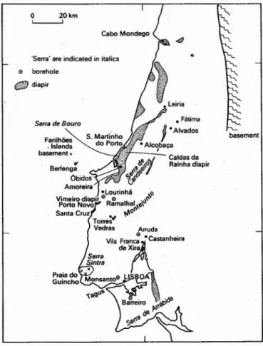
'Serra' are indicated in italics
Fig. 1 - Locality map showing places mentioned in the text
The brackish strata at the base of the Upper Jurassic occur nearly everywhere in the Lusitanian Basin. In only
two areas in the north of the basin, namely Alvados
(RUGET-PER ROT , 1961, p. 130) some 20 kilometres
east of Alcobaca, and at Cabo Mondego is the brackish
development underlain by marine strata which may be
Upper Oxfordian in age, or could represent continuous sedimentation from the Callovian. Unfortunately in the centre of the Lusitanian Basin (Sintra, and the Monsanto borehole) the basal part of the Upper Oxfordian is not encountered, and so in this region the relationship of the Lusitanian to older beds cannot be determined.
The base of the Portuguese Upper Jurassic is marked by an extremely important discordance, which increases
• Fatirna
J.
Alvados ·AI~ba~er
Caldasda e~.~j Rainhadiapir ~~~r,,-~\br!'(l
Praiado Guincho Farilh6es •Islands basement. Serra deBOUTO o borehole ([!jjf)diapir o 20 km L...--..JThe brackish·water sediments occurring at the base of
the Upper Jurassic also occur to the west of the Serra dos Candeeiros, being described at the edge of the Cesareda
Plateau by C. RUGET-PERROT (1961, pp. 102-103).
A map of this area by G. OERTEL (1956, fig. 5) shows the basal brackish unit at this locality to be extremely variable laterally, ranging from red conglomerates to
sandstones, through shales to limestones. In the whole of
this northern area the brackish development is referred to
as the Vale Verde Beds (see column 4 of table I). The
Leiria sequence was dated by C. TEIXEIRA and
G. ZBYSZEWSKI (1968) as Lower Oxfordian, but its
lithology is similar to facies that elsewhere are dated as Upper Oxfordian (ie. Vale Verde Beds).
Upper Oxfordian: Cabacos Beds and equivalents
At the base of the Oxfordian in the Lusitanian Basin,
the occurrence of a freshwater fauna (Planorbis.
Nerita, Cerithium. Paludina, Cyrena and Charophytes:
SEIFERT's (1963) faunal assemblage a) appears to be
ubiquitous (SEIFERT, 1963, pp. 299-300). At Torres Vedras the basal 20 metres of the Cabacos Beds are developed in this facies (RUGET-PERROT, 1961), with thin bedded bituminous limestones «<plaquettes»); these
are ov~rlain by 300 metres of thick bedded, fine grained
marly limestones dated by C. RUGET-PERROT (1961,
table 5, p. 172) as theGregoryceras transversarium Zone
in age. In the Montejunto area, C. Ruget-Perrot recorded
the Cabacos Beds resting on the Peltoceras athleta Zone
of the Callovian, thus proving the absence of the Lower Oxfordian. M. RAMALHO(l971, p. 29) supported this
conclusion, and suggested, on the basis of borehole
evidence, that south of the Tagus Estuary the basal unit of the Upper Jurassic is rather variable, ranging from brackish water to shallow marine limestones up to 130 metres thick. This basal group rests on limestones of
CalIovian age, but to the south in the Serra da Arrabida,
H. SEIFERT (1963, p. 297) described the Montejunto
Beds (which M. Ramalho dated as basal Upper Oxfordian rather than the Lower Oxfordian age suggested by H. Seifert) resting on an erosion surface which oversteps eastwards from Callovian onto Lower Lias. Above this erosion surface, which in places has a strong relief, occurs a basal conglomerate with locally derived Middle and Lower Jurassic limestone pebbles up to 30 centimetres
across; this is the famed ornamental Arrabida marble.
In the east of the Arrabida region, H. SEIFERT reported the occurrence of a brown pisolitic iron ore above the basal conglomerate, and described a lateral change from carbonates in the west to terrigenous c1astics in the east (1963, fig. 5).
The initial brackish water episode of the Upper
Oxfordian can betraced to the northern part of the
Lusi-tanian Basin, and in places, such as the Serra dos Can
-deeiros, it rests unconformably on an eroded, possibly
karstic surface, even developing a canyon in Middle Jurassic limestones (RUGET-PERROT, 1963, p. 133). In places the development of iron and bauxitic ores is reported (ZBYSZEWSKI and MOITINHO DE ALMEI-DA, 1960, pp. 27-28, FRANC;A and ZBYSZEWSKI,
1963, p. 33). According to H. Seifert (in
RUGET--PERROT, 1961, p. 133) the marine and brackish Lusita
-nian may reach 300 to 400 metres thickness in this area. for palynological methods of correlation have yet to be
applied to the non-marine strata. Furthermore, the
strati-graphic names used shouldberegarded as informal terms,
pending the revision of the lithostratigraphic nomenclature of the region to conform to widely recognised strati-graphic codes. Figure I is a map showing the positions of localities mentioned in the text.
in magnitude in the Arrabida region from west to east. and is present over the whole of the Serra dos Can-deeiros, and in all other sections associated with salt diapirs. Indeed. it appears that major salt movements in the Lusitanian Basin were initiated during Lower Oxfordian times.
Upper Oxfordian: Montejunto Beds and equivalents
The Montejunto Beds and their probable equivalents mark a period of generally marine conditions throughout the Lusitanian Basin. with the major exceptions of influxes of terrigenous sediments in the eastern part of the
Serra da Arrabida and to the north of Lisbon.
In the Sintra area (table 1. column I), the S. Pedro Limestones are contact metamorphosed by the late Creta-ceous Sintra granite. so their original lithology is largely destroyed by metamorphism. However, the succession in Monsanto borehole gives an indication of the lithology of the Montejunto Beds equivalents in the centre of the Lusitanian Basin (RAMALHO, 1971. pp. 95-96). Here. the upper part of the Upper Oxfordian is dominated by caIcirudites with bioherms (Ramalho's «Recifal
a
organismes encroutants»), being similar in the Barreiro boreholes (except in Well No. I, where a brackish episode with ostracods and Charas intervenes). A si-milar shallow water facies occurs in the western part of Arrabida, but the marine character is lost to thebioturbated sand (three symbols here represent total loss of other structures)
mudstone
1
wackestone increasing energy packstone of environment grainstone
pellets oolites pisolites
laminated algal dismicrite
Sandstone unit. with basal gravel deposit; becomes finer grained towards top; large scale planar cross bedding overlies erosional base, followed by trough cross bedding,with small scale cross bedding (ripple drift) at the top
LITH-OLOGY
a:(/)N~
::>="7~ O(/)~O
cS
~ 3l:8
solid bar indicates redo u. ~ coloured sediments ;
- - - I ] I dashed lines show faint
c ay or patchy red colour.
1
1i;llil;[~~J ~J
11 Sandstone u.nit: medium sand throughout, planarbedding, mudcracks at base, but no erosion.11
I]
c~rbonate
soil horizon (caliche)slit
Sedimentary structures or bioturbation--~-__ indicated here
Silt and clay sized sediments (terrigenous or carbonate) shown in black so that proportion of sequence deposited from. suspension may be judged at a glance.
(/) w Z
~
w ~ ::J Slump--z,-FOSSILS - See caption
B
TBR
B
d7
1 2 3 4d
5m
6EOO
7,1
8 c==o 12(])
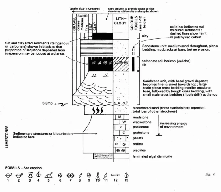
13 Fig. 2Fig. 2 - Explanation of lithological logsusedin figures 3, 4 and 7.Thesystemusedis based on the Shell Standard Legend (Royal Dutch/Shell Group 1976), with the left hand columnusedto showgrainsize variation rather than bulk sand content. The textural terms used for limestones (mudstones, wackestone etc.) are those defined by R. DUNHAM (1962). Most of the symbols used in the Figures are explained here. Those that are not shown inthis key Figure do not form an important basis discussion in the text, and so those interested in a comprehensive key are referred to the Shell Standard Legend.
1 Trace fossils - Thalassinoides
2 Trace fossils - Rhizocorallium
3 Lamellibranchs 4 Ammonites 5 Echinoids 6 Solitary corals 7 Colonial corals 8 Serpulids 9 Gastropods 10 Plant-roots
11 Plants - leaves, stems 12 Vertebrate remains 13 Brachiopods
east (RAMALHO, 1971, p. 136) being replaced by
terrigenous clastic sediments (SEIFERT, 1963, figs. 2
and 5). In the Torres Vedras and Montejunto areas (the
type area, table I, column 2) theMontejunto Beds are
350 metres thick, with an open marine fauna of bivalves
and ammonites, although oolitic horizons are present
(RUGET-PERROT, 1961). R. MOUTERDE et al. (1973)
recognised a separate «formation» at the top of the
Mon-tejunto Beds, consisting of 80-100 m of alternating shales and limestones, the latter sometimes containing in situ
coral colonies. They named this the Tojeira formation.
Further north, in the region of the Cesareda plateau,
the lateral equivalents of the Montejunto Beds exhibit a much shallower water aspect, and so the area marks a transition to the Pholadomya protei Beds development in the far north (see table I, columns 3 and 4), consisting
of some 600.metres of shallow water carbonates (<<Les
couches marines littorales- of RUGET-PERROT, 1961,
p. 103), containing H. Seifert's faunal assemblage d
(Corals, strornatoporoids , Trichites, algae) and some
ammonites. To the north,.the lateral equivalents of the
Montejunto Beds are, as previously stated, termed the
Pholadomya protei Beds, the occurrence of which is
recorded in the literature from Sao Martinho do Porto and
Alcobaca northwards to Cabo Mondego (see table I,
column 7) containing H. Seifert's faunal assemblage c
(Ostrea. Mytilus. Avicula , lsognomon, Ceromya, Pho-ladomya. Pecten. Nerinea, Terebratulids, foraminifera). The succession exposed in the Fatirna region (table I,
column 5) described by C. RUGET-PERROT (1961,
pp. 120-121) shows some 200 m of Pholadomya protei
Beds (termed «Couches marines
a
nombreuxlamelli-branches» by Ruget-Perrot) overlain by four alternations
of marine and brackish water limestones, [apparently an
alternation of H. SEIFERT's (1963) faunas a and b
tCvrena. Astarte, Corbula), and c], possessing a total
thickness of some 70 m. C. Ruget-Perrot gave no
indi-cation as to whether she considers these alternations to be equivalents of the Montejunto Beds, or younger.
In the Leiria region (table I, column 6), the lateral
equivalents of the Montejunto Beds also consist of shallow marine and freshwater brackish water limestones
(TEIXEIRA and ZBYSZEWSKI, 1968, pp. 61-64).
<K im m er id gia n: Abadia Beds and equivalents
In the Torres Vedras region, the calcareous silts, shales and sandstones comprising the Abadia Beds reach a
thi-ckness of 800 m (table I, column 2). R. MOUTERDE
et al. (1973) divided this sequence into a lower sandstone unit (the Cabrito formation) which they estimated to be
400 m thick in the Torres Vedras area, and an upper
shaley sequence (some 60 m thick) for which they retain the term Abadia marl formation. The Cabrito formation thins to the east, being absent on the south east flank of
the Montejunto massif, which R. MOUTERDE et al.
( 1973) interpret as indicating a westerly, rather than
easterly source for the influx of clastic sediments that
mark the beginning of'the Kimmeridgian. G. MEMPEL
(1955) described the Abadia strata as consisting largely of fine grained calcareous micaceous sandstones and siltstones, with abundant plant fragments, ripple marks,
cross bedding and slumping. Clay ironstone nodules
occur in the upper part of the sequence. Like R.
MOU-TERDE et al. (1973), Mempel recognised a threefold division of strata above the Oxfordian carbonates, with a thick sandstone sequence separating two argillaceous units.
The top of the Abadia strata is generally marked by a
calcareous facies, which may either be rich in bivalves
(the Lima pseudoalternicosta .Beds) or corals and algae
(the Amaral Coral Limestones, the Monte Redondo and
Ota Limestones). H. SEIFERT (1963) considered these
two types of facies to be local shallow water develop-ments at the top of the Abadia Beds, but M. RAMALHO
(1971, table I,p. 29) following P. CHOFFAT (190 1)
identifies the Lima pseudoalternicosta Beds as a unit
overlying the Abadia strata."
In the Sintra region, M. RAMALHO (1971),correlated
the Rarnalhao Shales with the Abadia Beds of the Torres Vedras region. Eastwards, in the Monsanto borehole, he
(RAMALHO, 1971, p. 96) recorded 900 m of Abadia
Beds, and compared them to the facies development at Sintra, whereas in the Barreiro boreholes he showed the
unit to be thinner (around 400 m), containing shales,
terrigenous sands tones and conglomerates similar to the
type section near Torres Vedras. M. Ramalho correlated
the younger «Shaley-rnarly limestones»of the Sintra area
with the Lima pseudoalternicosta Beds of the Torres Vedras area. He reported the occurrence of reefal
lime-stones at the top of these «Shaley-rnarly limestones».
M. RAMALHO (1971, p. 110) interpreted the influx
of terrigenous c1astics in the Barreiro boreholes as indicating the emergence of Palaeozoic basement to the east. Earlier workers suggested a similar derivation for
some of the coarse c1astics within the Abadia Beds, for
north of Lisbon, at Vila Franca de Xira, C. FREIRE
DE ANDRADE (1934) and G. ZBYSZEWSKI (1965) described a series of conglomerates with intercalations of reef limestone, and the latter author reported these to
be up to 1500 m thick. A similar association of
conglo-merates and reef limestones occurs in the exposures
around the Montejunto anticline; these were described
by G. MEMPEL (1955) and G. ZBYSZEWSKI and
O. FERREIRA (1966). G. Mempel (1) described in some detail the grain size and petrology of pebbles found in the conglomerates of the lower-most Abadia Beds, and
suggested an easterly source for them. He accounted for
the association of reef limestones and conglomerates-in
the Montejunto area by postulating that the carbonates
accumulated on a structural high in the basin, and that
(1) G.Mempel dated the Abadia Bedsas Upper Oxfordian but,as already discussed. the Abadia Bedsare now generally accepted to be
Kimmeridgian in age.
....~.... III V II -v-8(J) !l
SS
11 <>:i
Sj Ill!> ~E IIi
SS
11..
c ~SS
IIa
!
..
Sj
ci
0 a>i
$$ II ~~'"
1
w Il ~SJ
E :> Ill!) .g .l!jJ
Il 0 if IS 5S ll(!)5J
Il IlSS
II 10mI
S}!J
5m 4 5 3 2 BA-f!' l!~ lS II 5m z..
(i~ s G~g
..
<J.
-&- +J of-+ ';!""" -v-r- +i
E !l 0 <J.
~ 5mI
CD!
""'8,1-1
i~
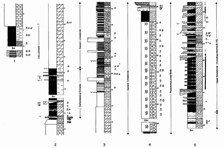
llDFig. 3 - Lithological log of the Upper Jurassicsequence exposedalong the coast southeast of Cabo Mondego. The names of the rockunits are those used by C. RUGET-PERROT (1963). The numbers on the right side of the columns refer to the heightin the succession,in tens of metres, above the Callovian. Unexposed portions of the sequence are not drawn to scale, but their extent is indicated (eg. base of
column 5 - gap of 5 m)
this feature also acted as a barrier to the westward spread
of the coarse clastic sediments, thus explaining the rapid
westward grain size decrease he described.
G. MEMPEL (1955) also studied the petrology of
pebbles found in the presumed lateral equivalent of the
Abadia Beds on the coast at Santa Cruz, west of Torres
Vedras . Like R. MOUTERDE et al. (1973), he cited a
westerly source for these sediments, on the grounds
that fine grained sediments occupy the centre of the
Lusitanian Basin, thus precluding the same source as
for the Montejunto conglomerates , and because of the
great similarity between the pebbles and the Hercynian
metamorphics and granite of the Farilh6es and Berlenga
islands to the north west (see figure I). G. Mempel
considered that the conglomerates (and reef limestones
where they occur) mark the eastern and western flanks of
the Lusitanian Basin. He showed a facies map for the
lowest Abadia Beds (MEMPEL, 1955, fig. 5, p. 122)
indicating the general north-south trend of the Lusitanian
Basin, with shelf-limestone facies occurring at its
nor-thern end. This latter conclusion was based on his own
work in the Montejuntoarea, and on that of G.OERTEL
(1956) in the Serra de El-Rei - Cesareda region.
G. OERTEL'S (1956)descriptionof the discordance at
the base of his «Kirnmeridgian- (equivalent to Abadia
Beds) around the Vimeiro diapir raises thequestion as to
whether the conglomerates of the Montejunto area really
do have reef limestones as their lateral equivalents, or
whether there is a discordance between them. In many
parts of the Lusitanian Basin, the Abadia Beds and their
lateral equivalents often rest discordantly on olderbedsin
the vicinity of diapirs . This is the case for the Matacaes
diapir near Torres Vedras, where the Abadia Beds rest
on Infra-Lias (ZBYSZEWSKI, 1965, p. 53), and also
around much of the flanksof the Caldas da Rainha diapir
(OERTEL, 1956, fig. 5) where the Abadia Beds rest
on basal Lusitanian strata (considered in this account to
be basal Upper Oxfordian, and not Lower Oxfordian as
suggested by Oertel). As can be seen from table I, this
discordance is widespread in the northern part of the
basin , and like the discordance underlying the basal
Upper Oxfordian is associated with salt movements.
North of the Cesareda plateau, the equivalents of the
Abadia Beds are the Alcobaca Beds, described as a series
of calcareous sandstones, fossiIiferous limestones, oolites
and pisolites by J. FRANCA and G. ZBYSZEWSKI
(1963). They are much thinner than the Abadia Beds to
the south, perhaps reaching two or three hundred metres
thickness at most. They have a fauna similar to that of
the Lima pseudoalternicosta Beds.
In the Leiria region, the presumed lateral equivalent of
the Abadia Beds is consideredto be the lower part of the
l5m • 8 3 -::.=-~~ --~-=-lOm ..
I__
~'
_I
• 16m : •••~ T . T• . : / i
30m.:JI
:",:::,::,~ ".".",...:-
'" 25m~.,+
~-e"1l
l5m ~..
.1
I
I
"" ::...
':
" '. :. " ""~w;~r"'~
""~:
" !l"
", " " """
~ " " ,1 ,I "~+
1+
Cl + + ."... ...A.. !Y -s-+"" -tr-~ ~ Cl 0i
."... +s. li...
'rt-
IIIli IIIli " & & " " a. a. ::> ::> 6 7 8 9 10Vale de Lagares Complex (table I, column 6), which contains a series of limestones and lignites which until fairly recently were exploited commercially (TEIXEIRA and ZBYSZEWSKI, 1968; HAHN and HELMDACH, 1971). According to F. Helmdach, these limestones contain abundant Charas. and so are reminiscent of the brackish limestones at the base of the Upper Jurassic. Portlandian
P. Choffat divided the Upper Jurassic above the «Lusi-tanian» into Pterocerian and Freixialian. M. RAMALHO (1971, table I, p. 29) suggested that these two stages are approximately equivalent to the Portlandian (sensu
gallico). It is only in the Sintra region that the uppermost Jurassic is wholly marine, and a passage into the Cre-taceous occurs in a marine carbonate facies, and even here, the System boundary is marked by a brackish «Purbeck» facies (e.g. see RAMALHO, 1971, pp. 57~ -58). In the Arrabida region (RAMALHO, 1971;' SEIFERT, 1963), the Portlandian shows an alternation of sands tones and limestones indicating conditions fluctuating from marine to continental. Elsewhere in the basin the Portlandian appears to be dominated by coarse sandstones and shales, with occasional marine bivalve horizons, whose content is reputedly distinct from that found in older strata (see SEIFERT, 1963, p. 294). It should' be emphasised that this' part .of the sequence is almost devoid of reliable zonal indices.
In the northern part of the basin, beds of presumed Portlandian age are referred to as «Gres Superiores
corn Vegetais e Dinossaurios-, and in several areas rest discordantly on older strata (see table I) usually around the flanks of diapirs.
Ill. UPPER OXFORDIAN ENVIRONMENTS Introduction
This section is based on the author's detailed study of Oxfordian carbonate success ions exposed south of Cabo Mondego and at S. Martinho do Porto, and supported by a reconnaissance field study of other localities.
Cabo Mondego and S. Martinho do Porto Figure 3 is a lithological log of the Oxfordian succe-ssion exposed south of Cabo Mondego. It shows that there is no major break between the Callovian and the overlying succession; indeed, it is difficult to be sure where the Callovian-Oxfordian boundary is situated, or whether Lower Oxfordian is present in this section. Above the ammonite-rich marls and limestones of the Callovian, there occurs, after a gap (covered by beach material), a 12 m sequence of silts with abundant
Exogyra and terebratulids. Above these the section may be divided into six principle parts; from the base up: i) 12-36 m (numbers on right side of lithological columns on fig. 3 refer to height in tens 63
i
..
.
'C .ll..
1-:-- -5 Upper~
eci ..S1
3 ndotO . . . +' -+--.
~5-+-....;Zf9.r
g
4 lZ0m1
i..
3 G 'C.
" .3..
i..
"•
" 3 :, i = 11 JJ!..
=~ ~ 'I g. ~ I1 :1JJ!
~~ ~h
g .!! 0 11 ~ 11 III1ft
g -e- :::'::':;,:lD~"
''+-,
I
g iI
;
..
~ 11111
a ~~ 1111 aGof
e~ ~~ 111 ~ 9:4 ~ 715m"
SSe
1:JI"
j
... .-'-;:.;~,:.~,. 1I c. ~~~~~~!;' ~!
.
"'V" /; "Ji
lam .!! ..~~
I
~ -s--7/"-'" ii 2 3Fig. 4 - Lithological log ofthe Upper Jurassic sequence developed on the north westflank of the Caldas<laRainhadiapir and exposed on the
cliffs from S. Martinho do Portoand northwestwards along the sea cliffs to Mangas. The names of the rock units are based on the accounts of C. RUGET PERROT (1963) and B. PARANT(1963). The figures on the right of the columns refer to the height in thesuccession,
in tens of metres, above the Vale Verde Beds. Unexposed portions of the sequenceare not shown to scale, but their extent is indicated
(eg. baseof column 4, 120 m gap not recorded - in this case because it isan inaccessible cliff section)
of metres above Callovi an ): a marine cream
coloured limestone (12-33 m) with well
deve-loped Thalassinoi des burrows on its bottom
surface. Most of the limestone unit is inaccessible
save during a combination of low tide and calm
sea conditions. It consist s of packstones and
grainstones containing a mixture of intraclasts of
probable algal origin and skeletal sand usually
dominated by echinoid debris. This unit is
overlain by 3m of coarse r grained less well
cemented carbonate containing pisoliths and
corals.
ii) 36-38m: This thin unit marks the first influx
of terrigenous clastic material , commencing with
olive silts, and followed by medium grained
sands. The beds are extremely fossiliferous ,
containing abundant Exogyra , /sognomon and a
variety of corals (lsastre a. Thamnasteria. C
ya-thopora, Montlivaultia , Rhabdoph yllia ) none of
which are in theirgrowth position (see plate lA).
iii) 38-49 m: In marked contrast to the underlying
beds, this unit has a freshwater aspect. Itconsists
of light grey siltstones, rich in wood fragments,
and containing small scale cross bedding, sand
lenses and flaser bedding. Near the top of this
unit, a sandstone lense occurs (see plate IB) and
is overlain by a thin lignite seam, followed by
a limestone containing Unio, Corbula, Paludina
and Planorbis . In addition to the root let beds
in the silstones, some horizons contain abundant
well preserved plant remains. Dinosaur footprints
have been reported from this unit"(LAPPARENT
and ZBYSZEWSKI, 1957). :
iv) 53-/2 9 m: The basal 25 m of this part of the
sectionconsists of slightly calcareous silts with a
few thin bandsof evently laminatedor r
ippledrift--cross bedded coarse sandstones, which are often
considerably load-casted. The remainder is a
rather featureless succession of massively bedded
calcareous silts, largely unfossiliferous.
v) 129-/96m: This part of the sequence consists of
three lithologies:
a) bioturbated dark grey sparse biomicrite (see
plate 2A), sometimes pelletoidal and conta
i-ning millimetre sized high spired gastropods
and Gervillia :
b) Laminated dismicrites (plate ID), containing
layers of micrite and ostracod debris (plate
2C), occasionally calcite pseudomorphs after
gypsum (plate 2B), and abundant Char a
c) Laterally persistent breccia horizons (plate l E), containing large blocks of the other litho-logies present in the sequence.
This sequence has been described briefly by R. WILSON (1975a) and compared to modern marginal marine-freshwater algal marsh deposits of Andros Island, Bahamas.
vi) 196-277 m: 288-300 m: These intervals are
characterised by «bivalve biomicrites-; they are grey, sparse biomicrites in bedded units up to I m thick, pelletoidal in places, with thin mar! partings. These limestones are intensively bio-turbated (plate IF), and contain an abundant, but comparatively restricted fauna of bivalves
tPho-Iadomya, Ostrea pulligera. Arcomytilus. Ger-villia, Perna, Trichites. terebratulids and small
high spired gastropo?s).
The succession exposed in the cliffs around S. Marti-nho do Portois shown in figure 4. Here, there are only a few metres of sediment below the «bivalve biomicrites-. These are coarse sandstones, with one breccia layer similar to those at Cabo Mondego. The limestone blocks in the breccia show algal textures similar to the Cabo Mondego sequence. A few metres below the section illustrated, there is a fault contact with the Triassic Dagorda formation. The «bivalve biomicrite» sequence is interrupted by about 60 m of reddish silts and thin sandstones.
Environmental interpretation
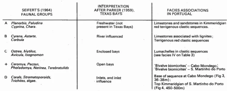
As already mentioned, R. WILSON (I975a) interpreted part of the Cabo Mondego sequence (129-196 m on fi-gure 3) as an ancient analogue of marginal marine and freshwater algal marsh sediments accumulating today on Andros Island, and described by GINSBERG and HARDIE (1975). The Oxfordian succession illustrated in figure 3 shows a transition from the open marine conditions of the Callovian to the continental f1uviatile clastic sediments of the Kimmeridgian. These transition beds contain freshwater and restricted marine faunas, suggesting that they were deposited in a marginal marine environment. H. SEIFERT (1963) recognised four distinct faunal assemblages in the Upper Jurassic of the Serra da Arrabida region to the south of Lisboa, and these assemblages strongly resemble some of those distin-guished today in the lagoons and associated environments of the Texas bays. Table 2 suggests the kind of envir-onments in which H. SEIFERT's (1963) assemblages may have lived. The red terrigenous clastic interval in the S. Martinho do Porto section, and the freshwater silts and sands in the Cabo Mondego sequence (fig. 3, 38--49 m) adds weight to the comparison with the Texas bay environments, for these sediments are similar to those formed in deltaic and marsh and lake environments in this region today (see DONALDSON et al., 1970: KANES, 1970). A summary of the environmental interpretation of the sequences is given in table 3.
CABA~OSBEDS
Basal Upper Oxfordian
o 20 km
L...---...J
dominantly marginal marine -freshwater algal marsh
emergent basement: source of clastics found to south east?
~~
*'
~ positive area: karst surface developed over Middle Jurassic carbonates?
_ mixed freshwater algal marsh and ? shallow marine
The Oxfordian in other areas
The lowest part of the Cabo Mondego sequence beneath the algal marsh sediments (ie. below 129 m on fig. 3) has not been found elsewhere during this reconnaissance study, and neither can it be recognised in any of the published accounts of lithological sucessions. Even on the coast at Pedrogao some 25 km south of Cabo Mondego, the algal marsh facies rests on Callovian. But the marginal marine - freshwater facies with its characteristic content of Charo appears at the base of the Upper Jurassic throughout the Lusitanian Basin, appearing as the Vale Verde Beds in the north, and the Cabacos Beds (2) in the south. The sequences do not exceed 160 m thickness at Cesareda and Montejunto, suggesting that the thickness given by many authors (summarised in table I, column 2) is excessive and includes part of the overlying Montejunto Beds. Several authors have described the latter formation as bituminous, presumably because of its characteristic oily smell when freshly broken. This facies may indeed have been a potential hydrocarbon source, not because it accumulated in a euxinic facies, but because of its original high content of algal material.
Fig. 5 - Palaeogeographic sketch map for the basal part of the
Upper Oxfordian (2) Referred to as the -Lusitanian B.. in some oil company reports.
Within the Cabacos Beds there is evidence for agitated marine conditions as well as the algal facies. In the Cesareda and Montejunto sections packstones and a few grainstones composed of intraclasts (possibly derived from fragmented algal mats), pisoliths and pellets occur. In the Barreiro boreholes, M. RAMALHO (1971) records the presence of Chara, ostracods, algae, large forams, and mollusc and echoinoid debris. Terrigenous red c1astics were recorded by G. OERTEL (1956) at the base of the Oxfordian to the south west of the Serra de El-Rei,
and demonstrated that they die out to the north east. Similar sediments, some 200 m thick, were encountered in the Lourinha borehole. The location of these c1astics in an otherwise predominantly carbonate succession is analogous to the influx of c1astics during the Toarcian in this region described by A. HALLAM (1971).
The bivalve biomicrites comprising the Pholodomya protei Beds do not extend to the south and south east of the Caldas da Rainha diapir, and neither does the red clastic interval within them. This suggests that the diapir was already in existence during the Upper Oxfordian. forming it barrier or shoal that influenced the deve-lopment and distribution of. sediments.
On the flanks of the Serra dos Candeeiros, the Upper Oxfordian is quite thin
«
100m). being termed the Serro Ventoso formation in an unpublished report by B. PARANT (1963). Further south, in the Serra de El-Rei and Montejunto regions, the succession is thicker: J.GOMES (1962) measured some 250m at Montejunto.and G. FERREIRA (1962) just under 1000m at Cesarada. All these southerly successions contain higher energy carbonates (packstones and grainstones) including oolite horizons. and they contain a more diverse fauna including bivalves, corals and some ammonites. In the Montejunto section. higher proportions of micrite indicate lower energy conditions. In the Montejunto sequence, the top part of the sequence is developed in a shaly lower energy facies which contains some corals; this was termed the Tojeira formation by R. MOUTERDE et al.
(1973). The descriptions of the sequences in the Mon-santo and Barreiro boreholes by M. RAMALHO (1971) indicate that similar deposits to those of Cesareda and Montejunto accumulated in this part of the basin. Palaeogeography
Cabacos Beds:Figure5 shows that during this interval, there was little contrast in environments across the Basin. Apart from the area of red terrigenous clastics of pre-sumed fluvial origin in the area south west of Peniche, and possibly in the east of the Arrabida region. the area of the Lusitanian Basin must largely have been at sea level - or just a few metres below in the south where there are shallow marine carbonates. The Serra dos Can-deeiros area developed a karstified surface, presumably during the Lower Oxfordiari, and according to published accounts (eg RUGER PER ROT, 1963)this is overlain by lignites in places.
Montejunto Beds: Figure 6 shows that the Caldas da Rainha diapirexerted a considerable influence ·on sediment type and distribution. separating shallow open marine carbonates from lagoonal bivalve biornicrites, and ponded back terrigenous sediments on its north west flank.
IV. KIMMERIDGIAN AND PORTLANDIAN
ENVIRONMENTS Introduction
In contrast to the Oxfordian, the Kimmeridgian of the Lusitanian Basin is dominated by clastic sediments, which to the north of Torres Vedras and Montejunto are almost entirely non-marine. The only exception to this pattern is the level of the Lima pseudoalternicosta Beds, which represents a period when marine conditions returned for a brief interval.
SEIFERrs (1964) FAUNAL GROUPS A Planorbis. Paludina Cyprina. Chara. .B Cyrena.Astene, Corbula C Ostrea, Mytilus, Avicula. Isognomon
+
Ceromve, Pecten,Pholadomya. Nerinea.Terebratulids
o
Corals. Strometoporoids, Trichites,algae. INTERPRETATION AFTER PARKER (1959). TEXAS BAYS Freshwater (not present in Texas Bays) River influenced Enclosed bays Open bays Inlets. and inlet.influence
FACIES ASSOCIATIONS IN PORTUGAL
Limestones and sandstones in Kimmeridgian red terrigenous clastic sequences.
Limestones associated with lignites;
Terriqenous red clastic sequences Lumachelles in clastic sequences (see facies IV on Table 3)
'Bivalve biomicrites' - Cabo Mondega: 'Bivalve biomicrites' - S. Martinho do Porta Base of sequence at Cabo Mondego (Fig 3.
36-38m);
Top Kimmeridgian of S. Martinho do Porta (Fig 4. 450-500m)
Table 2 - A re-inteIpretation of H. SEIFERT'S (1963) Upper Jurassic faunal assemblages
Cabo Mondego
Fig. 6 - Palaeogeographic sketch map for the higher part of the Upper Oxfordian
Figure 4 shows that the 250 metres of terrigenous clastics following the Oxfordian bivalve biomicrites are dominated by fine sandstones and siltstones, containing only a small proportion of coarser channel sandstones. Thus the floodplain environment is dominant here, and the streams showed a high sinuosity meander pattern (see plate 3A).
At the top of the section (376-386 m, 447 m to top on fig. 4), marine conditions are indicated by abundant bioturbation and the occurrence of bivalve Nerineiid and coral faunas, and pisolitic horizons (see plate 3 B). Traced laterally, only the marine horizons appear to be persistent, with the sandstones generally wedging out. About IOkm to the south west of S. Martinho do Porto (in the sea cliffs at the edge of the Serra do Bouro), a 20 m thick massively bedded limestone horizon is developed at this level. It is largely micritic, and contains mudcrack horizons and traces of algal laminations. To the south of Obidos, near the village of Amoreira, this unit rests unconformably on Bathonian limestones (see RUGET PERROT, 1963, fig. 24 for illustration). This unconformity has been recognised all around the Caldas da Rainha diapir by B. PARANT (1963), and around the Serra de El-Rei and Vimeiro diapirs by G. OERTEL (1956). This sub Kimmeridgian unconformity is yet more evidence suggesting that the diapirs were active during Upper Jurassic sedimentation. B. PARANT (1963) showed that the «Upper Sandstones-(of presumed Portlandian age) also have an unconfor-mable base, which may cut out all other Upper Jurassic strata and come to rest on Triassic Dagorda series in some localities. Parant also demonstrated that the red terrigenous clastics of the Abadia formation that characterise the north east side of the diapir are replaced to the south east by the dominantly oolitic, pisolitic and skeletal sand rich limestones of the Alcobaca Beds. This-provides more evidence in favour of the existence of the Caldas da Rainha diapir as a string of islands between which wind driven or tidal currents flowed leading to the deposition of high energy carbonates.
the oxidation of any ferromagnesian minerals in the sediments.
The assemblage of features, particularly the fining upwards units and fossil soil horizons suggests a fluvial environment, with deposition occurring from relatively low sinuosity meandering streams (see COLLINSON, 1978, for review of the features of fluvial sediments). Changes in sea level, or periodic waning in the volume of sediment input led to marine incursions, during which fluvial sands were reworked and often bioturbated, possibly within an interdistributary bay environment between fluvial/deltaic channels.
S. Martinho do Porto and the Caldas da Rainha Diapir
high energy. open marine carbonates
limit of shaley upperpart
- - - ' - (Tojera formation)
'bivalve
biomicrit:es~'
:iilll
Iluctuatinq ..._~" ?-=- mixed sequence: ? ? freshwaterIlagoon o o 0"~<100m thick or absent.
... especially adjacent to diapir
o 0 0
i1iapir barriei island : sequence thin or absent
Figure 3 shows that the Oxfordian carbonate sequence is followed by about 600 m of terrigenous clastics. Many of the sandstone units are characterised by fining upward sequences, in which coarse and medium grained cross bedded sandstones are replaced by red fine sands and silts, the latter sometimes culminating in the development of caliche horizons (fossil carbonate soils). A number of marine shale, mar! and sandstone horizons occur in the succession (see fig. 3 at around 342 m, 375 m, 422 m, 450 m, 665 m). Sediments immediately above and below these marine intervals lack the red colouration of the finer sediments which characterises the rest of the sequence, suggesting that higher water table levels associated with marine advances immediately after deposition prevented
o 20 km
"---J
MONTEJUNTO BEDS Upper Oxfordian
The interpretations presented in this section are based on studies of coastal sections and evidence afforded from existing reports and publications concerning the development of clastics inland. Further original work concerning the inland outcrops and wells, supported by palynological data to aid correlation might completely change the conclusions presented. However, without any reliable means of correlation, environmental interpreta-tions such as those presented here are the only means of providing a framework around which future investigations can be planned (see note added in proof.).
r h h . & dl
Propornon0 coarse me rum n situ ceIC e onzons FACIES sand to fine sand& Exoticconglomerates Caliche conglomerates (Types A and B as
silt (% indicates amount of coarser and gravels and gravels described by Steel.
sedimentin the sequence) 1974)
(i) 40-50% Polymictic:granite.phyllite. Absent Present .A&B but quartz,orthoclase feldspar not as abundant as in
facies(ii)&(vii)
(ii) 20-30% Absent Present. abundant in Types A&B well places developed (iii) 10% in S (S of Santa Cruz) Absent Present at base of Present.mainly A
20-40% to N'(faciessimilar sandstone to (ii) with addition of shell beds)
(iv) Only one coarse clastic 'Present:pebbles&cobbles of Absent Absent unitin>300m of silts granite.phvllite, quartz
(v) >50% Present (gravelsonly) : Absent Few. A orthoclase feldspar&quartz
(vi) 40-50% W of Lourinha quartzScattered c1asts: only&metaquartzites Present some B.Present. mainly A,but 30-40% S of Santa Cruz
(vii) >7 5% Common: only quartz& Common, but usually Very few metaquartzites developed exclusively
from exoticconglomerates
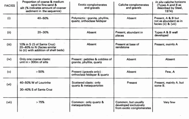
Table 3 - Summary of the features of the seven terrigenous clastic facies exposedinthe cliffsin the vicinity ofLourinhii, Porta Novo and Santa Cruz (see also Fig. 7)
Coastal sections between Praia da Lourinha and Santa Cruz
Along this 15 km of coast, most of which is flanked by cliffs up to 75 m high, seven distinct facies are
discernable in the Kimmeridgian and Portlandian clastic
sequence. As shown on fig. 8, it is possible to observe
two relatively continuous sections, spanning several
kilo-metres of cliff, and separated by approximately 7 km in a
north south direction. The only facies that can be traced
between the two areas is iii), which may be traced
eastwards, toward the basin centre, into the Lima
pseudoalternicosta Beds which mark the top of the
Kimmeridgian, The fact that the Santa Cruz diapir lies
between the two sections, and that apart from the marine
facies iii) there are few similarities between them-points
once more to the possibility of a diapir forniing a barrier
of some kind that exerted a control on sendimentation.
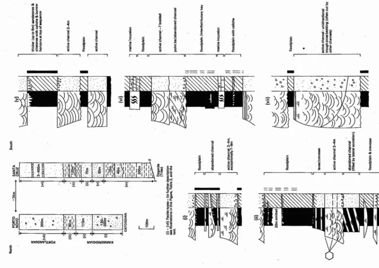
Figure 8 and table'3 together summarise the main
features of the facies types except that iii) an iv) are not
illustrated by summary logs in the figure, so additional
comments on them are given below:
iii) The base and top this interval is marked by shell bands, respectively termed key beds C and E by
B. TRZESNIOWSKI and H. SEIFERT (1958).
Bed C contains abundant lsognomon rugosa
(see plate 3C), and lesser numbers of Cyprina,
Mytilus and Ostrea. Bed E is dominated by
-Trigonia»lusitanica still preserved in aragonite,
plus Corbula, lsognomon rugosa, Cyprina,
Mytilus, Cerithium and Cidaris. Both these
beds were mapped over distances of 20 km by
B. Trzesniowski and H. Seifert. Other shell
horizons occur in the predominantly silty
sequence south of Santa Cruz.But to the north of
Porto Novo only key beds C and E remain, and
the sequence is comparable to facies ii) with channel sandstones and caliche horizons. The southward decrease in sand content of the
sequence, and the more marine character of the
sediments in this direction suggest a fluvio-deltaic complex building out onto a shallow shelf. Key
bed C may represent a delta abandonment facies,
with other shell beds being wave winnowed lag deposits.
iv) The bulk of this facies consists of grey green
fine sandstones, siltstones and mudstones, the
coarser fractions usually being bioturbated.
However, the most interesting feature is the
40 m tan coloured sandstone sequence, at the
base of which occurs the polymictic conglo-merate (plate 3D) described by G. MEMPEL (1953). This sandstone unit channels down into
the siltstones with a relief of at least 10cm,
Fossil wood and debris Marine horizons Red colour presentin: Intepretation
Absent. Absent overbank and abandoned FLUVIAl. low sinucs itvmeander belt/braided
channel deposits stream
Abundant. includinglogs Absent overbank deposits only .FLUVIA L - high sinuosity meander belt
andin situroots
Present Common.but fewer to N some silts DEUAIC - distributary channel and inter-channel
bays or abandonement faciesin north;
distributarybays and pro-deltain south
Abundant Silt r:. probably entirely none SUBMARINE FAN - sandstone unit deposited in
manne distal channel
Common near base One horizon only. - 10m only in silts and fine DELTAIC .- delta plain withlarge.fluvial channels
from base sands
More common at base. Only south of Santa Cruz overbank deposits FLUVIAL - in north. Iow sinuositymeanderbelti
andin south braided streams
FLUVIO·bELTAIC- in south;moderate sinuosity river channels & interdistributarybays
fine grainedsands & silts Absent Onlyin finergrade FLUVIAl.-braided river system.possibly distal
sediments end I)f alluvial fan
wide and 10 cm deep) are developed on its bottom surface; they indicate currents flowing from the north west. The isolated stack of this sandstone that stands proud of the beach at Santa Cruz shows faintly planar partings that are inclined (if the steep tectonic dip is removed) towards the east in sandstone with scattered pebbles. The inclined partings were probably formed by lateral accretion in this direction. Above this are flat bedded sandstones with abundant lignite fragments and showing crude grading with «floating" pebbles which are also well exposed in the main cliff (plate 3E). The sequence becomes finer upwards and changes to decimetre bedded medium sands -tones, again with lignite, and small scale cross bedding and some slump horizons. This litho-logy grades up into laminated silts with orange weathering ironstone nodules similar to those of the Abadia formation inland at Torres Vedras. The features of the sandstone part of this facies .
are suggestive of deposition in a channel in the proximal part of a_ submarine fan (but in a distal part of the channel). ,
The possibility that diapiric movements may account for the considerable differences between the two clastic
.sequences shown in fig. 7 has already been mentioned. Although no time correlation is possible between the sequences, it does appear that in early Kimmeridgian times the Santa Cruz area was sommewhat lower than that around Porto Novo, for the former sequence shows progressive basin
fill
towards sea level (starting with. submarine fan deposits) whereas the latter shows deposits formed progressively nearer base level.(as indicated by the interpreted increasing sinuosity of the stream sedi -ments).This suggests that fault movement occurred along the line of diapirs. Detailed analysis of the clastic .sequence in the Lourinha and Ramalhal boreholes might
confirm or refute this hypothesis.
Reef limestones
The term «reef» is used rather loosely in the Lusitanian Basin, and seems to include any carbonate formation in which appreciable quantities of corals'are found. In the uppermost Kimmeridgian, banks of limestone,such as the Monte Redondo Limestone and the Ota Limestone deve-loped around the margins of the Lusitanian Basin. The latter formation, which is situated on the north eastern side of the ArrudaBasin (see fig. 8), is up to 100 m thick, thinning out to a few metres in a lateral distance of about I km (CHAMEAU, 1962). However, a recon-naissance visit by the author failed to locate any reef debris material, and so the formation is probably not a reef in the true sense,but perhaps a build up of carbonate sediments on a change in depositional slope (the slope break of BALL, 1967). It isprobable that all the «reefs» marked on P. RICHE's (1963) facies map are carbonate banks and bioherms developed on a slope-break .
However, the Upper Kimmeridgian of the Lusitanian Basin does contain a true reef complex, although previous accounts do not describe it. The coastal sequence of the Sintra region (Praia do Guincho) described by M. RAMALHO (1971) contains a number of features that
-i
I
l · :j .Et
J
1
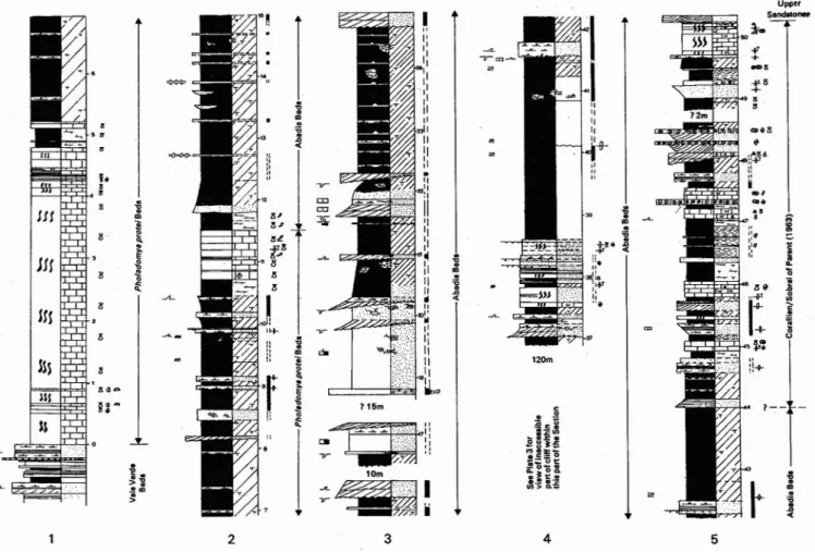
r-lr----l',---,r---,"'-,,----, NYlOOIU3WWI~ ~ NYlCNYuHOd ,---",---,Fig. 7 - Facies variation in the Kimmeridgian-Portland terrigenous clastic sequencesin the vicinity of the Santa Cruz-Vimeiro diapirs (the «axis» of the diapiric structure passes between the two columns shownin the top left diagram).
The columnsin the top left of this figure show the approximate thicknesses of the different faciestypes; they are based on personal field observations, supplemented by data from B. TRZESNIOWSKI and H. SEIFERT (1958) and B. PARANT (1963).
The five lithological logs are diagrammatic summaries ofallbut two of the facies.Full descriptions ofallseven facies are givenin Table 3 and the text.
identify it as a reef facies complex totalling around one kilometre in thickness. The description given in table 4
is a reinterpretation, based on personal examination in
the field, and on M. RAMALHO's (1971) published section. The complete reef complex is only developed at this locality. To the east only the back reef facies is developed.
Torres Vedras and Arruda areas
The eastward thinning of the clastic Cabrito formation described by R. MOUTERDE et al. (1973) has already
been described. As yet, no detailed study of this
formation has.been made, but graded beds containing
only Unit A of the Bouma turbidite sequence, together with flute and groove casts have been observed by the author in loose blocks of the Cabrito formation to the south of the Montejunto Massif, after being alerted to
their presence by F. Gradstein (personal communication,
1978).
Further to the east, the Kimmeridgian clastic sequence is developed in yet another facies. On the eastern border
of the basin at Vila Franca de Xira and Castanheira,
arkosic conglomerates and.gravels are developed. They
were first described by C. ANDRADE (1934), and logs
of their upper part were made by J.CHAMEAU (1962).
They consist of large angular pink feldspar clasts mixed with more rounded granules of Mesozoic (presumed Lower and Middle Jurassic) limestones. 1. Chameau noted that the topmost parts of the arkosic sediments to contain coral colonies, and observations by the author at Vila Franca indicate that some of these colonies, which
are several
~etres
across, are inverted, perhaps having«tumbled» into their present position. J. CHAMEAU
(1962) showed the arkosic sediments interfingering with.
more normal Abadia facies to the west. The Arruda
borehole penetrated 2.5 km of Kimmeridgian sediments,
and much of this thickness comprises coarse arkosic
sediments (see fig. 8). C. ANDRADE (1934) suggested
that these sediments were associated with contemporary
Portlandian palaeogeography
Upper Kimmeridgian palaeogeography
late Kimmeridgian erosion to east of this line 7 submarine fan/alluvial fan building out from fault scarp
o o shallow water -high energy limestones fluvial: high sinuosity meandering streams and coastal plain basement
~
-v-, diapir - barrier islando 20 km
~
fore-reefbreccias ....
7 submarine fan
low energy silts. marls& limestones
Figure 10 is a palaeogeographic sketch for the Upper Kimmeridgian. The slope break discussed earlier is marked by a number of carbonate banks, and the Caldas da Rainha diapir continues as an emergent feature,
LOWER ABADIA/CABRiTO Lower Kimmeridgian
Fig. 9 - Palaeogeographic sketch map for the lower part of the Kimmeridgian, based partly on personal observations, and partly
on data from P. RICHE (1963)
that the Cabrito formation thins to the east. Such a westerly source could be the proximal submarine fan (and perhaps others like it) postulated earlier in this paper at Santa Cruz.
Figure 9 is a palaeographic sketch map for the Lower Kimmeridgian based largely on the earlier discussion in this paper. Once more, the influence of the Caldas da Rainha diapir-barrier is clearly demonstrated. The development of the reef complex in the south of the Basin may be indicative that it fringed a deep ocean-presumably the newly formed southern North Atlantic. A similar facies, of comparable age, forms the Abenaki carbonate of the Scotian Shelf off eastern Canada (ELIUK, 1978). possible proximal submarine fan V. . channel ,,!,e~ro ' \ . Dlapll
. '\.5
# o,
Lower Kimmeridgian palaeogeography
The isopachyte pattern shown on fig. 8 (from RICHE, 1963) reveals two distinct Kimmeridgian sub-basins (Bombarral and Arruda) separated by the Torres Vedras--Montejunto high. In the Arruda Basin, the sequence of arkose sediments accumulated to the incredible total of 2.5 km. Given the presence of the Torres Vedras high, and the fact that the Cabrito formation contains no limestone clasts in its graded units, it seems unlikely that the Cabrito sands were derived from the fan-sediments of Vila Franca and Castanheira. R. MOUTERDE et al. (1973) suggested a westerly derivation on the grounds this facies (taken from RICHE, 1963) suggest deposition in an alluvial fan or submarine fan environment backed by a fault scarp.
Fig. 8 - Isopachytemap for the Kimmeridgian of the southern part of the Lusitanian Basin, based on P. RICHE (1963), with additional information concerning the Cabrito formation fromR.MOUTERDE
et al. (1973)
No palaeogeographic sketch map is presented for this interval, as the basin north of Santa Cruz and Torres
marine horizons , in the form of nodular bioturbated
biomicrites replace the clastics. In the Sintra region,back
reef carbonates are developed. During this period, there
is no indication that the central region is a relatively
more rapidly subsiding depocentre as is the case in the
Kimmeridgian.
V. EVOLUTION OF THE LUSITANIAN BASIN Introduction
The purpose of this section is to summarise the main
events in the development of the Lusitanian Basin, to
discuss the structural controls of facies distribution and
thickness, and to relate the Basin's evolution to events
leading to the opening of the Atlantic Ocean.
During the Upper Jurassic, the Lusitanian Basin
deve-loped a unique range of facies types and distributions,
and subsided at relatively rapid rate (in places in excess
of 10 cm per 1000years), so it seems that this period
marks a turning point in its development. Lower and
Middle Jurassic palaeographic patterns are quite simple,
with, in the Lias, sediments thickening to the north, and
shallowest sediments to the southof the Basin (WILSON,
1975b fig. 2B, C). In the latter part of the Middle
Jurassic, the pattern changes somewhat, with one
depo-.centre between Cabo Mondego and Peniche, and another
to the south, in the Torres Vedras/Montejunto area
(RUGET-PERROT, 1961, p. 185).
Main events in the Upper Jurassic
I.Lower Oxfordian. To date, no sediments ofthis age
have been proved in the Lusitan ian Basin. Thus it is
probable that during this interval the area was subjected
to general uplift , plus localised elevation over diapiric
structures. After this movement, erosion and/or
subsi-dence levelled the area, so that it was approximately at
sea level, as demonstrated by the ubiquitous algal marsh
facies ,and algal marsh-marginal marine facies at the base
of the Upper Oxfordian (see fig. 5). Exposed areas of
Middle Jurassic (Serra dos Candeeiros) developed a karst
topograph y during this interval.
RAMALHO'SBED
SUGGESTED
NUMBERS.NAME & AGE BRIEF DESCRIPTION
THICKNESS ENVIRONMENT , Cl) « ell e Z 0 ti
s
ell Cl Nodularsparseskeletalwackestones.with BACK REEF
29 E -65m z 'occaslonel onfitic/pelleto idalhorizons LAGOON
:.:i « ~ ...J I-::l a: "'C 0 0 e, z Cl) ell e 0 ti z ell E
s
PATCH REEF25-28 :.:i - 75ni Cl Coral and algal boundstones.
u z
:
€
« "0 ...J U I-e a: 0 0 c, I23.24 -115m z Decimetrebeddedskeletal wackestones INTER-REEF.
s
LOW ENERGY20-22 Cl)
- 150m o Limestones,breccias,withcorals;marly BACK REEF
ell Cl
e intercalations TALUS
0 a:
ti W
ell ~
19
,§
-40m ~ Massivealgal boundstone with dispersed MAIN REEF> ~ corals:algal material contains Birds-eye MASS
~ W structures;unit shows possible quaqua
-...J
E Cl quaversal dip pattern
>-
Clell
2-18 Ris: -180m ~ Alternationof limestonebreccias (containing PROXIMAL FORE
-(J) algaltexturesand corals) and shaley- REEFTALUS
marly horizons
Cl) w
ell ...J7
Ri Cl~
s:
Cl-1 (J)0 >10m,total thickness ~Cl-~ Shales withlimestonebreccias between DISTAL FORE·
'1lI probably -400m lit: 10-50cm thick,with thicke r'slide'units REEFTALUS
s:
a:W containingblocks up to 3-4m across
Ri
E w~
III 3:~
a: 0
-...J~
Table 4 - Preliminary re-interpretationof M.RAMALHO'S(1971) Kimmeridgian-Portlandiansection at the northernend of Praia doGuincho,