A PLUGIN FOR SPATIAL
AND THEMATIC COMPARISON
IN THE CADASTRAL DOMAIN
Dissertation supervised by
PhD Professor Marco PainhoInstituto Superior de Estat´ıstica e Gest˜ao de Informa¸c˜ao Universidade Nova de Lisboa, Portugal
PhD Professor Angela Schwering Institut f¨ur Geoinformatik
Westf¨alische Wilhelms-Universit¨at M¨unster, Deutschland
PhD Professor Joaqu´ın Huerta
Departamento de Lenguajes y Sistemas Inform´aticos Universitat Jaume I, Castell´o de la Plana, Espa˜na
ACKNOWLEDGMENTS
I would like to express my appreciation to the following persons for being so important
during this period of my life:
- My Forever friends Alex, M´ario and Ant´onio Farinha. See you one day. Bless.
- My “Scout Brother” Jorge for the Java guidance. Long life to you.
- My Parents, Brother, Sister, Grandparents and Aunt for being my meaning in life.
- My Best Friend Ana Magina and Family for educating and taking care of me.
- My Supervisors, specially Prof. Marco Painho for the support and comprehension.
- My Municipality DIR. Baptista Fernandes and Ant´onia Lima for believing in me.
- My “Brothers” Pathak, Diyan, Sanjana and Andrew for the friendship and support.
- My “Second father” Jos´e Garcez and “Second Sister” C´elia. A real life inspiration.
- My “Brother” Diogo, Sara and Tiaguinho. THANKS for all words of encouragement.
- My Erasmus “Brothers” Chima, Mussie, Teshome, Maia, Pearl, Farah, Adriana,
Malumbo, Ermias, Neba, Jan, Handy, Julius, Bayes, Dipak, Sherzod, Carlos, Irene,
Mauri, Onyedika Amin, Fabiano, Paulo, Saroj, Francis, Ashwin and Sushil for showing
me so many good ways to see life.
- My “Giant” Friends Vanessa (thanks for helping me so much), Carlos (a real Brother),
Ricardo, Guida, Ricardo “Brad”, Patr´ıcia, Pedro “Malibu”, Sofia, Manuel, Dion´ısio,
Novais, Juca, Elsa, Coelho e Coelho, Henrique, Carlinhos, Tiago, Rita, Chicalito,
Lu´ısa, Ivo, Anabela, D´ario, Hugo, Diogo, Hacke, Roland, Peter, Andy, Paulo, Olivia,
Carmo, Irene, Nuno Pint˜ao, Vitor and all the Scout “Brothers” for being by my side.
- My friend Carlos Reis for showing me Urban Intervention and McCoy Tyner.
- My Professors Filipa Taborda, Lu´ıs Rodrigues Pedro Cabral, M´
ario Caetano, Cristina
Costa and all my other professors for educating and supporting me.
- To my GOD for taking care of me.
- To all who supported me and complicated my life. Without you i was not in Peace.
A PLUGIN FOR SPATIAL
AND THEMATIC COMPARISON
IN THE CADASTRAL DOMAIN
ABSTRACT
Over the years, the Municipalities have been dealing with a growing number of
requests for cadastre use updating. In most cases, these requests originate from the
owner’s will to perform an urban intervention in a parcel. Urban intervention are
defined as physical operations of urbanization, construction and use of land. To issue
an urban intervention permit for a parcel, the authorising municipal entity has to
conduct a Spatial and Thematic comparison between the existing municipal rustic
cadastral cartography and the urban intervention project.
The aim of this research is to develop a database and ontological framework
that incorporates Spatial and Thematic verification to support the describes cadastre
update and facilitate the automation of the process within municipal entities.
The development of an object relational database management system is
supported by an Entity-Relation model compliant with INSPIRE data specification
on theme Cadastral Parcels and ISO/LADM models.
The Methontology method
is applied to model a decree-law ontology that enables the representation of legal
relationships between the municipal master plan and the urban land use categories.
The
Spatial comparison
operation uses a spatial predicates set based on the
Calculus Based Method to test and classify relationships between the rustic and
urban geometries. The
Thematic comparison
performs a set of operations to
as-certain the relationship between rustic and urban categories, extract and assign its
annotation to the urban project. Finally, a free and open-source Java Plugin
The Plugin provides an efficient platform for the executation of data
visuali-sation and comparison, although it is limited to the information retrieved from the
analysis of the Spatial and Thematic relationships. An assessment on distinct design
principles demonstrate that the integration of the selected information technologies
can ensure the adaptation of the Plugin to the various cadastre update processes
existing in the Municipality.
The proposed cadastral database model can facilitate the integration of the
municipal cadastre update process in the future SiNErGIC platform.
The use of
free and open-source GIS and Semantic Web technologies can efficiently support less
sophisticated cadastral operations and assist the customisation and adaptation within
the municipal entities.
Overall, the Spatial and Thematic comparison operations
implemented in the Plugin, can contribute to automation and celerity of the cadastre
KEYWORDS
Application Ontology
Cadastre Update
Cadastral Database
FLOSS GIS
Ontology Engineering
Spatial Comparison
ACRONYMS
API
– Application Programming Language
CBM
– Calculus-Based Method
CC
– Cadastral Cartography
CCDM
– Core Cadastral Domain Model
CS
– Cadastral System
DBMS
– Database Management Systems
DL
– Description Logics
E-R
– Entity Relation
EPSG
– European Petrol Survey Group
FAO
– Food and Agriculture Organization
FIG
– International Federation of Surveyors
FLOSS
– Free/Libre Open-Source Software
GIS
– Geography Information Systems
GML
– Geography Mark-up Language
GUI
– Graphical Unit Interface
IDE
– Integrated development Environment
IGP
– Portuguese Geographic Institute
INSPIRE
– Infrastructure for Spatial Information in Europe
IPCC
– Portuguese Institute of Cartography and Cadastre
ISO
– International Organization For Standardization
IT
– Information Technologies
LA
– Land Administration
LADM
– Land Administration Domain Model
MRSC
– Multipurpose Real State Cadastral
OGC
– OpenGIS Consortium
ORDBMS
– Object Relational Database Management Systems
OWL
– Web Ontology Language
RDBMS
– Relational Database Management Systems
RDF
– Resource Description Framework
SDI
– Spatial Data Infrastructure
SINERGIC
– National System for the Operation and Management of Cadastral
Information
SQL
– Structured Query Language
STDM
– Social Tenure Domain Model
SW
– Semantic Web
UML
– Unified Modelling Language
UN
– United Nations
UN-Habitat
– United Nations Human Settlements Programme
W3C
– World Wide Web Consortium
TABLE OF CONTENTS
TITLE ii
ACKNOWLEDGMENTS iii
ABSTRACT iv
KEYWORDS vi
ACRONYMS vii
INDEX OF TABLES xiii
INDEX OF FIGURES xiv
1 INTRODUCTION 1
1.1 Background . . . 1
1.2 Motivation . . . 3
1.3 Aim and Scope . . . 3
1.4 Research Objectives . . . 4
1.5 Research Questions . . . 4
1.6 Study Area and Data . . . 4
1.7 Approach . . . 5
1.8 Thesis Structure . . . 6
1.9 Tools . . . 7
2 STATE-OF-THE-ART 8 2.1 International Cadastral Information Systems . . . 8
2.1.1 Until 1994 . . . 8
2.1.2 The beginning of the end for old fashioned Cadastral Systems . . . 8
2.1.3 Cadastre 2014 . . . 9
2.1.4 A Cadastral Core Domain Model based on Cadastre 2014 . . . 10
2.1.5 FIG CCDM v1.0 . . . 11
2.1.6 LADM release . . . 12
2.1.7 From LADM to ISO19152 . . . 12
2.2 Cadastre in Portugal . . . 14
2.2.1 The year of the Multipurpose Real State Cadastral . . . 14
2.2.2 The IGP foundation . . . 16
2.2.3 The beginning of SiNErGIC project . . . 16
2.3 The municipal cadastre update process . . . 17
3 THEORETICAL BACKGROUND 19 3.1 Institutions & standards overview . . . 19
3.1.1 FIG . . . 19
3.1.2 OGC . . . 19
3.1.3 W3C . . . 20
3.1.4 FAO . . . 20
3.1.5 European Commission INSPIRE Directive . . . 20
3.2 Database Management Systems . . . 21
3.2.1 Spatial databases . . . 21
3.2.2 E-R Model . . . 21
3.2.3 SQL . . . 22
3.3 Semantic Web . . . 22
3.3.1 Knowledge Representation . . . 23
3.3.2 Semantic Web Technologies . . . 24
3.3.3 Description Logics . . . 26
3.3.4 Reasoning . . . 26
3.3.5 XML . . . 27
3.4 FLOSS . . . 27
3.4.1 Free software . . . 27
3.4.2 Open-source software . . . 28
3.4.3 FLOSS Applications . . . 28
3.4.4 Java . . . 29
4 CONCEPTUALISATION 30 4.1 Methodology . . . 30
4.2 Conceptual Framework . . . 31
4.2.1 S Module . . . 31
4.2.2 T Module . . . 34
4.2.3 C Module . . . 37
5.1 Database Design . . . 42
5.1.1 Logical Data Model . . . 42
5.1.2 Physical Data Model . . . 45
5.2 Logical Ontology Design . . . 48
5.3 Framework Implementation . . . 51
6 EVALUATION 54 6.1 Workflow . . . 54
6.2 Test datasets . . . 54
6.3 Testing . . . 55
6.4 Strengths and Limitations . . . 56
7 DISCUSSION AND CONCLUSION 57 7.1 Research Objectives . . . 57
7.2 Research Questions . . . 58
7.3 Overall Conclusion . . . 60
7.4 Directions for future research . . . 60
BIBLIOGRAPHIC REFERENCES 61 APPENDICES 71 1. Map of Oeiras . . . 71
2. SiNErGIC Technological Infrastructure . . . 71
3. INSPIRE CPM derived from ISO LADM . . . 72
4. Entities selected for the Municipal Cadastral Database . . . 72
5. Knowledge Acquisition . . . 73
6. Glossary of Terms . . . 73
7. Binary Relations Table . . . 73
8. Concept Dictionary Table . . . 74
9. Logical Axioms Table . . . 75
10. Cadastral Parcel Attribute Table . . . 76
11. Cadastral Parcel Database Table . . . 77
12. Cadastral Parcel Foreign Key . . . 77
13. Ontology Schema . . . 78
14. Ontology Class - LandParcel . . . 79
15. Ontology ObjectProperty - hasRelation . . . 79
18. Possibly Accepted Sub-concepts in DL . . . 81
19. Not Accepted Sub-concepts in DL . . . 82
20. NetBeans GUI . . . 83
21. OpenJump Database Java Connection . . . 83
22. SAXParser API Connection . . . 83
23. Java Swing Panel . . . 84
24. Consistency Checking Java Implementation . . . 84
25. Store Proceedings Implementation . . . 85
26. Acceptance Checking Implementation . . . 85
27. Comparison Results Visualisation in OpenJump . . . 86
28. Possibly Accepted Areas . . . 86
INDEX OF TABLES
3.1 Excerpt of a RDF/XML document structure. . . 25
3.2 Excerpt of an OWL2/XML document structure. . . 26
4.1 Entities collected from the municipal cadastral database. . . 32
4.2 Entities considered in the proposed cadastral database model. . . 33
4.3 Relationship description of the Entities of the proposed cadastral database model. 33 4.4 METHONTOLOGY Requirement Specification Document. . . 35
5.1 Primary and Foreign Keys for each entity of the Cadastral Database. . . 44
5.2 Spatial Comparison and Consistency checking in SQL. . . 47
5.3 Qualitative and Quantitative functions performed in case of a Contains relationship. 48 5.4 OWL Class in RDF format. . . 50
5.5 Java implementation of Spatial comparison operation. . . 53
5.6 Java implementation of Thematic comparison operation. . . 53
INDEX OF FIGURES
2.1 Update procedures for a parcel division. . . 17
2.2 Muncipal cadastre update process. . . 18
3.1 An Entity-Relationship (ER) Diagram. . . 22
3.2 Some of the elements that can compose a SQL statement. . . 22
3.3 Tim Berners-Lee Semantic Web Layer Cake. . . 24
4.1 Conceptual Framework . . . 31
4.2 E-R model of the proposed cadastral database. . . 33
4.3 METHONTOLOGY life cycle . . . 35
4.4 METHONTOLOGY Concept Classification Tree . . . 37
4.5 Use Case Diagram for C Module. . . 38
4.6 Six toplogical relationships (based on CBM) . . . 39
4.7 Spatial comparison and Consistency checking flowchart. . . 40
4.8 Consistency checking - Possibly Consistent Classification Flowchart. . . 41
4.9 Plugin Interface Mock-Up Prototype. . . 41
5.1 Final E-R model. . . 45
5.2 pgAdmin III GUI . . . 46
5.3 pgAdmin III Main Window . . . 46
5.4 Prot´eg´e Main Window . . . 49
5.5 Structure and relationships of a Possibly Accepted Class. . . 51
6.1 Test Datasets. . . 55
6.2 Plugin query results. . . 56
1.
INTRODUCTION
This thesis proposes a free and open-source Java Plugin to performSpatial comparison using a object relational database management system andThematic comparison supported by a semantic web technology, within the cadastral domain.
1.1
Background
With the beginning of a 'new era' after the end of the Second World War, the United Nations (UN) started to be interested and play an active role on Land Administration (LA) and cadastral related issues. In the beginning of the 80’s, following the exponential increase of population, land use and new geographic information technologies, the researches concerning reforms on land information systems became more intense and covering wider perspectives. This evolution tendency made international agencies sensitive to future Cadastral System (CS) models.
However, CS that until some years ago were only used as 'fiscal' records by the public sector and as 'legal' records by the private sector (cited in Larsson, 1991), started to be regarded as a vital legal instrument for economical, social and environmental management and development (Kaufmann and Steudler, 1998). In 1994, the International Federation of Surveyors (FIG) published a document called FIG Statement on the Cadastre (FIG, 1996). From this statement the UN assumed Cadastre as “...normally a parcel based, and up-to-date land information system containing a record of interests...geographically referenced to unique, well-defined units of land” (FIG, 1995).
However, two years after the CCDM version 1.0 had been released, Hespanha et al.(Lemmen and van Oosterom, 2006) presented at the FIG Working Week 2008 in Stockholm, Sweden, the version 1.1 of the CCDM now dubbed Land Administration Domain Model (LADM). This change is due to fact that “the term 'land administration'better covers the full scope of the model” and “the term ’cadastral’ was not perceived by everyone to cover both the legal/administrative side and the geometric side such a registration.”. In this document the LADM-PT was also described: a LADM Country Profile developed to cover Portuguese cadastral reality. The described research proved to be very important because of the experiences and lessons learned concerning the derivation of a Country Profile from LADM.
Prior to 1995 the cadastre in Portugal was only geometric and its main purpose was to be a land use inventory. This type of cadastre is called rustic, and does not cover the legal ownership of land parcels. Since 1995 the Portuguese Institute of Cartography and Cadastre (IPCC) initiated the country’s multipurpose real state cadastral (MRSC) project, by classifying and mapping the land properties as rustic or urban cadastre parcels. Before this change, the cadastre information was dispersed by distinct institutions and characterized in order to serve the needs of each institution, being complicated (and time consuming) to connect and share information of each land parcel (Veigas, 2002). To help on how to deal with such issues and others related, the Decree-Law nr. 172/95, dated July 18th, was published to regulate MRSC for Portugal (DL, 172/1995). Due to economical and development issues, the MRSC project suffered economical and technological delays and was never initiated.
However, in 2006, the Resolution of the Council of Ministers nr. 45/2006 (RCM, 45/2006) proposed the creation of a National System for the Operation and Management of Cadastral Information (SiNErGIC), in order to enable the implementation of a national real estate cadastral information system. The SiNErGIC was mainly conceptualized and modelled based on Cadastre 2014 and CCDM. It is intended that, in future, the SiNErGIC ensures an interoperable and transversal CS, making possible the registration, execution and dissemination of cadastral information within the same technological infrastructure.
change; parcel designation change; and parcel elimination. It is expected that, in the future, these updating procedures will be automated and managed mainly by public authorities such as Local Offices, Land Registry Offices and Municipal Entities.
1.2
Motivation
The CC is an important tool in the municipal, infrastructure and environmental land management. However, in some situations, CC can be complicated to deploy due to the constant changes that it is exposed to. These occurrences come from Spatial and Thematic order, and in most cases are originated by changes in the use of parcels or in updates of the PDM. Over the years, the Municipality is dealing with a growing number of requests for cadastre use updating. In most cases the owner’s will to perform an urban intervention in a parcel originate these requests.
To issue an urban intervention permit for a parcel, the authorising municipal entity requires the owner to deliver a preliminary project draft. One of its basic requirements is a map consisting of the geo-referenced boundary. In order to accept that draft, the municipal entity has to conduct a comparison between the existing municipal rustic CC and the urban intervention map delivered by the land owner. For comparison between both data sets some Spatial and Thematic analysis have to be applied. This research proposes to develop a free and open-source framework to support the automatic verification of Spatial and Thematic changes between cadastre parcels.
1.3
Aim and Scope
1.4
Research Objectives
As a result of the identified problems, aims and scope of the research, the objectives are:
• Update of municipal database model to make it compliant with the INSPIRE cadastral parcel and ISO LADM models;
• Design and development of Spatial comparison method based on spatial predicates using Structured Query Language (SQL);
• Design and development ofThematic comparisonmethod based on a semantic web lan-guage; and
• Implementation of a customised Plugin within a free and open-source Geographic Information Systems (GIS) software.
1.5
Research Questions
• How can the use of customised free and open-source GIS and Semantic Web Technologies improve the performance of cadastral operations executed by the municipal authorities?
• How can a spatial database and ontological framework benefit the automationSpatial and Thematic comparison within the cadastre update process?
1.6
Study Area and Data
This research will take place in Oeiras municipality (see appendix 1.), Portugal. Oeiras is a town and a municipality in western Lisbon metropolitan having approximately a population of 171,000 inhabitants. The WGS84 geographic coordinates of the council are on 38°41’N and 9° 19’W, with an area coverage of about 45.8Km2 and having a total number of 10 parishes
(C.M.O, 2009).
This research proposes to use municipal rustic cadastral data and urban cadastral data that will be obtained from the municipality and from the data contained in the project draft delivered to the Municipality by the land owners, respectively.
1.7
Approach
This research consists of four phases: Literature review, Conceptualisation, Design and Evaluation.
The literature review phase comprises two parts: in the first part is provided a re-view of the past, present and future cadastral researches on an international and national level; and in the second part, a review of existent organizations, standards and available open-source GIS and Semantic web technologies relevant to this research.
The conceptualisation phase defines the structure of the framework. The database E-R model based on Infrastructure for Spatial Information in Europe (INSPIRE) cadastral standards (INSPIRE, 2009) will be depicted. Applying the Methontology (Fernandez, Gom´ez-Per´ez, and Juristo, 1997) method a decree-law conceptual ontology model will be devel-oped. Finally, the graphical unit interface of the Plugin will be represented using a mock object.
The design phase presents the designing and implementation of the conceptual framework. Based on the E-R schema developed during the conceptualisation phase, the database will be developed in two stages: the design and physical. Supported by the conceptual ontology, a decree-Law application ontology will be created. Finally, the Plugin will be design and imple-mented using a programming language with the intent to connect the database and the ontology.
1.8
Thesis Structure
This thesis is structured in seven chapters. The first chapter introduces the topic and its relevance to the cadastral scenario in the Oeiras Municipality. In order to clarify the choices, the hypothesis and objectives are pointed out and stated. Closing the chapter, the chosen approach is explained and discussed.
Chapter two gives an overview of International and Portuguese cadastral main events since 1994 until the present days, trying to underline the importance of new adopted models to support and update existent land management and cadastral systems. To enrich this topic some characteristics and findings are also described for both cases. Closing this chapter, the cadastre update process carried out by the technicians of the Oeiras Municipality is discussed.
Chapter three gives a literature review on organisations related with cadastral, ex-istent cadastral, geo and web standards, relational object databases, semantic web technologies and free/libre open-source software (FLOSS). Based on this brief analysis and with the intent to support the objectives previously defined in the first chapter, the main guidelines and points covered on the conceptualization of the framework are presented and grounded.
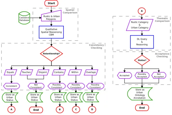
Chapter four starts with a diagram of the conceptual framework of the research. Each module and package is enumerated and the Spatial comparison, Consistency
checking, Thematic comparison and Acceptance consistency methods are explained. Also, technical and legal issues are enumerated and reviewed in order to bring the proposed model closer to the existent municipal reality. Based on these points, the conceptual ap-proach of the database schema to be generated, the methodology adopted to support the development of the conceptual ontology and a sketch of the Plugin to be designed are described.
Chapter six describes the evaluation of the framework implementation. Firstly, a workflow of operations is presented and, secondly, the test dataset is introduced and described. Based in these two sections, the characteristics, components and processes are tested and compared taking into account the municipal cadastre update process. This chapter ends with a discussion of the strengths and limitations of the framework.
Chapter seven holds a debate covering the research objectives and questions. To close this document future work is pointed out and commented.
1.9
Tools
In this research all the software that will be used is free or open-source. The Operation System that will support all the applications is theLinux Ubuntu 10.04 LTS. The written part will be processed in OpenOffice 3.3.0 suite and the final product generated in LATEX through Kile 2.0.85. The diagrams will be draw in the diagram editorDia 0.97.1and in theCmapTools 5.04.01. The images will be edited in the image editor GIMP 2.6.8; The research documents will be organised in the Mendeley Desktop 0.9.8.2. The E-R model will be designed in the
MySQL Workbench 5.2.31. The database will be developed and implemented in the Database management SystemPostgreSQL 8.4.1 with PostGIS 1.4.0 and accessed through the pgAdmin
2.
STATE-OF-THE-ART
2.1
International Cadastral Information Systems
2.1.1
Until 1994
With the beginning of a'new era'after the end of the Second World War, the UN started to be interested and play an active role on land administration (LA) and cadastral related issues. Early in the 1950’s, the Food and Agriculture Organization (FAO) contributed with a series of studies addressing land registration processes. Among them one discussing the rights in land was selected and used until the appearance of new cadastral reforms (model). In the beginning of the 80’s, following the exponential increase of population, land use and new geographic information technologies, the researches concerning reforms on land information systems became more intense and covering wider perspectives. This evolution tendency made international agencies sensitive to future CS models.
2.1.2
The beginning of the end for old fashioned Cadastral Systems
CS that, until some years ago, were only used as ’fiscal’ records by the public sector and as 'legal'records by the private sector (cited in Larsson, 1991), started to be regarded as a vital legal instrument for economical, social and environmental management and development (Kaufmann and Steudler, 1998). In 1994, the FIG published a document called FIG Statement on the Cadastre (FIG, 1996). From this statement the UN assumed Cadastre as “...normally a parcel based, and up-to-date land information system containing a record of interests...geographically referenced to unique, well-defined units of land” (FIG, 1995).
2.1.3
Cadastre 2014
In 1998 after four years of work, the FIG brought to light the Cadastre 2014 - A vision for a future cadastral system. This document developed by the FIG Commission 7 presents a modern cadastral 20 year vision that perceives changes on “the role of governments in society,...relationship of humankind to land,...influence of technology on cadastral re-form,...influence of technology on cadastral reform,...changing role of surveyors in society...and growing role of the private sector in the operation of the cadastre” (Kaufmann and Steudler, 1998). FIG defined Cadastre 2014 as “a methodically arranged public inventory of data concerning all legal land objects of a certain country or district, based on a survey of their boundaries” (Kaufmann and Steudler, 1998). This data inventory contains “...The outlines of the property, the identifier together with descriptive data, may show for each separate land object the nature, size, value and legal rights or restrictions associated...In addition...contains the official records of rights on the legal land objects.” (Kaufmann and Steudler, 1998).
Cadastre 2014 vision discusses the re-engineering of existent LA and CS based in a conceptual LA system. This conceptual model reflects the idea of a standardized and complete multi-purpose CS, designed to be an active part of any national spatial data infrastructure (Williamson and Ting, 2001) (Kaufmann and Steudler, 1998). The core essence relays on six statements as guidelines to promote a complete documentation of public and private law and legal systems, to redefine the role of cadastral mapping for cadastral modelling, to encourage the use of digital spatial objects and models, to ensure a better cooperation between public and private domain, and to stimulate the investment ensuring a return. Out of these statements this document also discusses how Cadastre 2014 vision can be used to support sustainable development, to help in land use planning, to contribute for political stability, and to support economy. This approach was the turning point from the old to the new system, although still very focused on the CS and on the technological changes and less concerned on defining a structure for cadastral domain model (Larsson, 1991).
a constant suggestion to use Geo-ICT languages such as OIL and XML, for engaging data exchange and integration.
2.1.4
A Cadastral Core Domain Model based on Cadastre 2014
Even with the works and studies conducted, such as ESRI ArcGIS Parcel Data Model (van Meyer, 2004), CS continued heterogeneous, and it became more and more imperative to find solutions to standardise the existing models. In the end of 2002, van Oosterom and Lemmen (2003) presented at a workshop in Delft, Netherlands, the progresses made to develop an international CCDM based on OpenGIS Consortium (OGC) (OGC, 2007) and on International Organization for Standardization (ISO) 19100 geographic standards. This work was developed with two major goals: to support “extensible basis for efficient and effective cadastral system development based on a model driven architecture” and to “enable involved parties, both within one country and between different countries, to communicate based on the shared ontology implied by the model” (Hespana et al, 2008). To ensure dissemination and implementation of the CCDM in different organizations, such as municipalities or governmental agencies, the use of available Geo-ICT standards is incentivated. The model was designed and documented based on UML standards making it possible to be applied in Geographical Data Base Management Systems (Geo-DBMS), implemented in Java making use of OGC standards or even translated to XML/Geography Mark-up Language (GML) (van Oosterom and Lemmen, 2003).
enabling data sharing on a national or international level; and that development of software should be considered in a next phase. Another work presented was Cadastre 2014 From vision to GIS by Bjorsson (2004). This paper draws attention to the importance of Cadastre 2014 implementation as the first step of any cadastral information systems; to the number of available GIS technologies capable to implement a cadastral management system; to the CS that needs to follow standards and be interoperable; to the importance to have CCDM as foundation; and that GIS products for cadastral management should provide functions such as rule-based topology, multi-user access and interoperability between systems.
2.1.5
FIG CCDM v1.0
By the end of 2006 at the FIG CongressTS 12 Cadastre 2014 and Cadastral Modelingin Munich, Germany, Lemmen and van Oosterom (2006) presented the version 1.0 of the FIG CCDM. After four years of research, papers, meetings and case studies, a refined version capable to be implemented in organizations at different national levels and to provide communication through standardized processes emerged. The proposed model was divided in five aspects represented by UML coloured coherent parts: Legal/Administrative (Yellow); Person (Green), Immovable Object Specializations (Blue); Surveying (Pink); and Geometric/Topological (Purple). The described division by'packages' was conceptualized to provide more flexibility of adaptation, development, implementation, and maintenance of each part of the model. Like already proposed in previous versions, the core of CCDM is represented by the relationship between Subject (persons) and Real Estate Object (land) via Rights (people land relation) (van Oosterom et al, 2006). This indirect communication is the main essence of land tenure and in CCDM it is represented by the relationship between Person (Green) and RegisterObject (Blue) through RRR (Right, Restriction, Responsibility) (Yellow).
maintenance process and an aligned vision with emergent information technology is suggested (Lemmen and van Oosterom, 2006).
2.1.6
LADM release
Two years after the CCDM version 1.0 had been released, Hespana et al (2008) presented at the FIG Working Week 2008 in Stockholm, Sweden, the version 1.1 of the CCDM now dubbed LADM. This change is due to fact that “the term 'land administration' better covers the full scope of the model” and “the term'cadastral'was not perceived by everyone to cover both the legal/administrative side and the geometric side such a registration.”. Such conclusion gained relevance by comments of experts from UN-Habitat and ISO/TC 211 when the first attempt to transform LADM into an ISO standard (New Work Item Proposal, NWIP 1859, CCDM) was being developed. Besides the change in the name (and regarding the latest model version), two other differences are noteworthy: some subclasses with less meaning were excluded, and the model is now fully compliant with ISO 19107 Spatial Schema. In the same document that LADM v1.1 was introduced, the LADM-PT was also described: a LADM Country Profile developed to cover Portuguese cadastral reality. The describe research proved to be very important by the experiences and lessons learned concerning the derivation of a Country Profile from LADM.
2.1.7
From LADM to ISO19152
Draft International Standard (DIS) (Lemmen, 2009). Again, just like in previous occasions, it was suggested that FIG, CEN, OGC, ISO, and other communities connected with the GIS industry, continue the contribute for LADM development and implementation into national and local Spatial Data Infrastructures (SDI) worldwide.
2.1.8
From to 2010 to 2025
In 2010, one year after the presentation of ISO19152 CD, Uitermark et al (2010) presented From LADM/STDM to a spatially enabled society: a Vision for 2025 at the World Bank Annual Bank Conference on Land Policy and Administration in Washington D.C., USA. In this presentation, the recent demonstration of STDM and a vision for LA system towards the year of 2025 were discussed. Regarding the future of STDM, the use of this model regarding the revitalisation of developing countries land systems was appealed. The importance of stimulating open source communities and commercial software providers to develop new land information software based on the LADM specifications was also highlighted. The vision for 2025 was developed on the expectation of some advancements that would help build a
'spatially enabled society': Maturation of information infrastructures; Development of social and economic dynamic process models; Expansion of administration systems for 3D/4D Space+Time objects; Harmonization of land object registration system; Straightforward update procedures for land object registration; Improvement of standards for data exchange at global level; Formalisation of semantic web technology; Increase of mobile applications development; expansion of monitoring applications for Geographical information infrastruc-tures; and availability augmentation of land information from public sector side. The previous expectations were pointed out as basic needs for public/private entities to perform future land analysis, predictions and decisions. In short the 2025 vision has LADM and STDM as a present and future basis to “register worldwide the information-related components of Land Administration (LA) in a standardized way” (Uitermark et al, 2010). A very important future mark for LA and CS will be the release of ISO19152 as an International Standard IS on June of 2011.
cadastral and land registration information are discussed. From the beginning, commercial off-the-shelf products are becoming the basis for developing information infrastructures, but due to economical constraints, it is necessary to develop and maintain efficient and cost effective tools for them to be used, improved and shared between cadastral and land experts. Open Geo-DBMS and GIS desktop applications are versatile and can be adapted concerning present issues or improved for future needs. Even when making use of the described features, the open source software’s are far from getting into a comfortable position and to offer secure solutions, being of major interest to test and try to integrate them more and more with national and local land administration systems.
2.2
Cadastre in Portugal
2.2.1
The year of the Multipurpose Real State Cadastral
Prior to 1995 the cadastre in Portugal was only geometric and its main purpose was to be a land use inventory. This type of cadastre is called rustic, and does not cover the legal ownership of land parcels. Since 1995 the IPCC initiated the country’s MRSC project, by classifying and mapping the land properties as rustic or urban cadastre parcels. Before this change, the cadastre information was dispersed by distinct institutions and characterized in order to serve the needs of each institution, being complicated (and time consuming) to connect and share information of each land parcel (Veigas, 2002). To help on how to deal with such issues and others related, the Decree-Law nr. 172/95, dated July 18th, was published to regulate MRSC for Portugal (Decree-Law nr. 172/1995).
This document reinforces the idea that a precise knowledge of real state cadastre is essential for a proper infra-structuring, use and management of the land and a vital support for economical activities that depend on it. The new cadastral model was conceptualized to help modernise the public administration, to represent the real state cadastral domain and to be an active part in the Portuguese development. To support this model some articles from previous Decrees-Law were preserved, others repealed and new ones introduced. From the discussed decree-law only the relevant articles for this research will be enumerated (Decree-Law nr. 172/1995).
extracted from the national cadastral map. The first point from the sixth article reveals that the existent rustic cadastre will be valid until next renewal operation. The second article of the chapter one defines that a land parcel is characterised by its administrative and geographic location, geometric configuration and area. The administrative location is defined by the district, municipality and parish where the land parcel is located. The geographic location is defined by the position of their boundary in the adopted coordinate system. The geometric configuration is defined by the cartographic representation of a closed polygon and the area is the mathematical value of that boundary. The sixth article points out that each land parcel has an unequivocal numeric code (NIP) and that this code is mandatory to be present in all public documents as an identification of cadastre land parcels. This code is part of the parcel identification card. Each cadastral parcel is represented in a cadastral section that is part of the national cadastral coverage (Decree-Law nr. 172/1995).
The point one of the ninth article states that the IPCC competences related to Portuguese rustic and urban cadastral are: a) implementation, renewal and conservation of MRSC in any Portuguese administrative areas; b) construction and maintenance of networks to support the operations described in the preceding point and establishment and management of the corresponding databases; c) issue of parcel identification card; d) Certification of geograph-ical location, geometric configuration and identification of land parcels; e) Establishment of standards and technical specifications for MRSC; and h) approval of cadastral works executed by other entities. The second point of the ninth article states that the IPCC may request the collaboration of public and private entities for the performance outlined in points a), b) and e) (Decree-Law nr. 172/1995).
2.2.2
The IGP foundation
In 2002, IGP was created by fusion of the IPCC and the National Centre of Geographic Information (CNIG) and made official by the Decree-Law nr. 8/2002, from January 1st
. This document assigns competences and responsibilities to: define references for rustic and cadastre land parcels; recognize referenced properties; issue real state identification cards; support assessment of real state properties; maintain and update cadastral data and information; and provide certification of existent cadastral elements (Decree-Law nr. 8/2002).
One of the IGP major challenges is to harmonise and coordinate the articulation between different institutions. From all those entities the IGP must ensure, with the General Directorate of registries and Notaries (DGRN), with the General Directorate of Taxes (DGCI) and with the Property Register Conservatories, the mutually exchange and update of real state data information. Even with such clear competences, the IGP deals with a difficult task regarding the harmonization of Portuguese Real State Cadastre. Until all institutions ensure interoperability standardised methods and processes among their information systems, the lack of cadastre information will be a strong barrier on progress and development of Portuguese cadastral panorama (Decree-Law nr. 8/2002).
2.2.3
The beginning of SiNErGIC project
In 2006, the Resolution of the Council of Ministers nr. 45/2006 proposed the creation of a National System for the Operation and Management of Cadastral Information (SiNErGIC), in order to enable the implementation of a national real estate cadastral information system. The SiNErGIC was mainly conceptualized and modelled based on the Cadastre 2014 and the CCDM. It is intended that, in future, the SiNErGIC ensures an interoperable and transversal cadastre system, making possible the registration, execution and dissemination of cadastral information within the same technological infrastructure (see appendix 2.) (Resolution of the Council of Ministers nr. 45/2006).
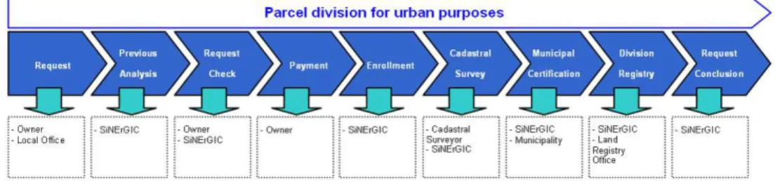
(IGEO, 2009). The presented example (see figure 2.1) is composed by nine stage, being the seventh stage (Municipal Certification) one of the main motivations of this research.
Figure 2.1: Update procedures for a parcel division (IGEO, 2009).
The update process starts with the land parcel owner requesting through SiNErGIC a parcel division for urban purposes (first stage). With the cadastral survey finished, the owner uploads the data in the SiNErGIC platform (sixth stage). The SiNErGIC mechanism validates and stores the survey. After that, the platform notifies the Municipality and asks for the division certification. In this stage (seventh), the Municipality’s role is to certify “that the parcel division for urban purposes update fulfils all the legal requires and its jurisdiction”. To issue the certification into the system the municipality has to first perform some analysis operations to be sure if the request is valid or not. If the analysis results are satisfactory, the municipality will certify the request through the platform, but if the results are unsatisfactory the request is denied. In the last stage (ninth) the SiNErGIC platform assigns the new NIP to each involved parcel and update online the cadastre information (IGEO, 2009).
It is expected that Municipalities start to use real state cadastre information as ba-sis for development and implementation of PDM when SiNErGIC reach to its full operation stage. Until SiNErGIC reaches maturity, the IGP will continue to work on implementation of the Geometric Cadastre of Rustic Property Information System (SICGPR). This project consists on the conversion of rustic cadastral maps into raster and vector format in order to preserve historic records, maintain updated existent data and improve information access (IGEO, 2009).
2.3
The municipal cadastre update process
uses of land consider six categories and are defined by the Decree nr. 11/2009. This Decree also states that each land use should be compliant with the municipal PDM in order to be regulated and accepted. The PDM is the basic tool for planning and aims to define a coherent model of development based on a set of objectives and a strategy that promotes a balanced occupation of the soil (Resolution of the Council of Ministers nr. 15/1994).
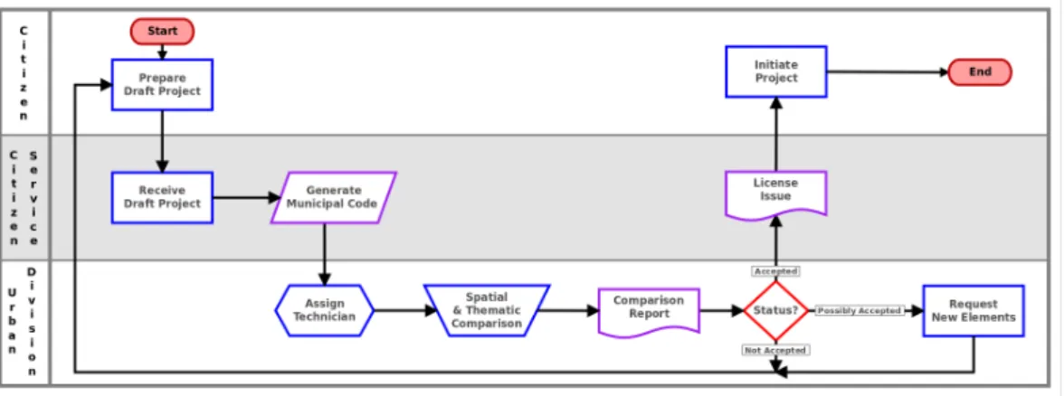
To issue an urban intervention permit for a parcel, the authorising municipal entity requires the owner to deliver a preliminary project draft. One of its basic requirements is a map consisting of the georeferenced boundary. In order to accept that draft, the municipal entity has to conduct a comparison between the existing municipal rustic cadastral cartography and the urban intervention map delivered by the land owner.
The spatial verification is based on a geometry comparison and usually executed using computer-aided design (CAD) tools. The thematic verification is based on a comparison between the parcel land use designated in the PDM and the urban land use proposed for the urban intervention. This comparison is commonly based on a interpretation founded on the law and on the knowledge of the technician. The results of these comparisons are classified, described in a report and then remitted to the land owner. This update process based on a urban intervention project is fully depicted in figure 2.2.
3.
THEORETICAL BACKGROUND
The previous chapter introduces an overview of cadastral systems evolution on an interna-tional and nainterna-tional level. From this progression, some of the enforcements made by different organizations to create international standards are pointed out, in order to create common rules and facilitate interoperability between heterogeneous systems. This chapter presents the theoretical background research made about the relevant topics for this project. Section 3.1 gives an overview of the institutions related with the development of the cadastral models described in the chapter 2. Section 3.2 focuses on spatial Relational Database Management Systems (RDBMS) and its components. Section 3.3 introduces the semantic web definition and describes some of the semantic web technologies that help to ensure interoperability among existent cadastral applications. Finally, section 3.4 highlight some of the concepts of FLOSS relevant for this research.
3.1
Institutions & standards overview
3.1.1
FIG
The F´ed´eration Internationale des G´eom`etres (FIG) was founded in 1878 in Paris, France. It is an international organization that represents globally the survey community and more than 100 countries all over the world. The FIG has as members in its group: National associations connected to surveying disciplines (members associations); Surveying associations (affiliates); Organizations, institutions or agencies that provide surveying commercial services (corporate members); and Organizations, institutions or agencies that provide surveying education or research (academic members). The FIG technical work is distributed by ten commissions, being each commission managed by a delegate of one member association. All the technical work related with cadastre and land management is coordinated by Commission 7. Furthermore, this commission is divided in three working groups: 7.1 – Development of Pro Poor Land Management and Land Administration; 7.2 – Development Sustainable Land Administration to Support Sustainable Development; and 7.3 – Application of Innovative Technology in Land Administration (FIG, 2011).
3.1.2
OGC
compa-standards. This interoperable and public standards are available with the purpose to bring geographic capabilities into geospatial and location based services. In 1997 OGC brought to public a first technical document named as OpenGis Simple Features Specification (SFS). This standard suggests procedures to store digital geographic data composed by spatial and non-spatial attributes. Since the release of SFS, standards such as the OpenGis Geographic Objects Interface Standard (GOS), the OpenGIS Geography Markup Language Encoding Standard (GML) and also the OpenGIS Simple Features Specification For SQL (SFSS) were developed and continuously updated. OGC vision is based on a spatial platform of products and ser-vices where developers and users can participate actively in the creation of new international
'geo-standards'(OGC, 2011).
3.1.3
W3C
The World Wide Web Consortium (W3C) was founded in 1994 by Tim Berners-Lee, the
'father'of the World Wide Web (WWW). The W3C is mainly focused on creating protocols, guidelines and materials to support the WWW development and its potentiality. This inter-national consortium has the mission to produce high-quality standards grounded on the active participation of members, experts, Web community and public. In order to better organise this intensive participation and to proceed with its mission, the W3C is composed by: working groups that produce deliverables, interests groups that gather people to perform evaluation and coordination groups that promote communication inside and outside the organisation. All the work developed by these groups stand on the following principles: a'Web for all' , a'Web on everything' , a'Web of data and services' and a'Web of Trust'. The W3C present and future vision point towards a Web built based on participation, knowledge sharing and global trust (W3C, 2011).
3.1.4
FAO
The Food and Agriculture Organization (FAO) was founded in 1945, is part of the UN and its primary goal is the fight against hunger around the World. FAO assumes the paper of neutral mediator between countries with the objective of promoting agreements and discussions on agriculture, forestry, fisheries practices and global nutrition (FAO, 2011).
3.1.5
European Commission INSPIRE Directive
INSPIRE Thematic Working Groups provides guidelines to promote the interoperability and implementation of a large number of spatial data sets and services.
The INSPIRE D2.8.I.6 Data Specification on Cadastral Parcels is a document that provides guidelines for the harmonisation on the geometrical aspects of the existent cadastral systems in the European Union. This document describes a data model compatible with the upcoming international standard on LADM (INSPIRE, 2009).
3.2
Database Management Systems
3.2.1
Spatial databases
A spatial database system is an information management system that is capable of dealing with spatial data by making use of spatial data types, spatial indexing, spatial operators and spatial application routines. This spatially enabled system was primarily designed with the intent to pre-process and process data so that it could later be analysed and modelled by the GIS desktop applications. These applications were also providing means to access, updating and extraction of the spatial data contained inside the database systems. In the present days, with the evolution of the IT and standards, spatial databases are growing in capabilities and functions such as: different types of geometries; topological, projective and metric operators; semantic reasoning; and spatial SQL. In consequence of this exponential development, it is now possible to deal more and more with spatial data without making use of GIS desktop applications (Yeung and Hall, 2007).
3.2.2
E-R Model
3.2.3
SQL
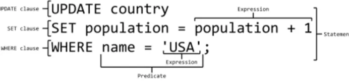
The Structured Query Language (SQL) was designed with the intent of dealing with data from RDBMS. This declarative query language, originated in the relational algebra, started to be more applied when Codd developed a relational model to be applied in database man-agement systems. In order to perform an extensive number of operations with the data stored in RDBMS, the SQL is composed by language elements such as'Clauses','Expressions',
'Predicates','Queries'and'Statements'(figure 3.2). These elements are invoked in SQL through the use of the Data Definition Language (DDL), Data Manipulation Language (DML), Data Definition Language and Data Control Language (DCL) (Culturalview, 2010).
Figure 3.1: An Entity-Relationship (ER) Diagram (Chen, 2002).
Figure 3.2: Some of the elements that can compose a SQL statement (Culturalview, 2010).
3.3
Semantic Web
3.3.1
Knowledge Representation
3.3.1.1 Ontology
“An ontology is an explicit specification of a conceptualization.” (Gruber, 1995), being conceptualisation an abstract representation of the domain knowledge to be described. Although the ontological research for knowledge management and sharing had its exploitation in Artificial Intelligence (AI), it quickly became essential to more areas of the computer science as well to other communities (Fonseca et al, 2000).
Understanding the generality level of an ontology is vital to an appropriate knowl-edge representation and extraction in the conceptualised domain. For this purpose Guarino (1997a) suggests four types of ontologies grouped into three levels of dependence: Top-level ontologies have the intention to illustrate broad concepts such as space, time, object, event, action, etc., independently of a specific domain; Domain ontologies and task ontologies have the intention to cover the vocabulary of a wide domain or a wide task or activity, by depicting the terms included in the top-level ontology; Application ontologies is a specialisation of the domain and task ontologies and it is defined to be used with a specific application (Guarino, 1997b). ”In that sense, they tend to translate the user necessities regarding a particular application, as for example, some spatial analysis operations in the context of the GIS software.“(Painho, 2007).
Defined the type of ontology that better represents a specific domain, the following design criteria should be taken in account: 'Clarity', 'Coherence', 'Extendibility', 'Minimal encoding bias', and 'Minimal ontological commitment' (Gruber, 1995). Finally, it is vital that the resultant ontology contains the following elements: 'Lexicon'; 'Concepts'; 'Semantics properties','Semantic relations', and'Relations'; and'Axioms'(Tomai and Kavouras, 2003).
3.3.1.2 Methontology
3.3.2
Semantic Web Technologies
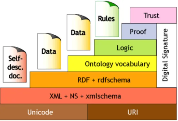
In 1998, the W3C created the Web Metadata Working group with the intent to develop the Resource Description Framework (RDF) Model and the RDF Schema Specification. However, the work progression was limited and consequently in 1999 the United States of America (USA) Defense Advanced Research Projects Agency (DARPA) initiated the DARPA Agent Markup Language (DAML) programme. This project opened new trails to the SW development by bringing some innovative approaches to the existent problems. At the end of 2000 at the XML 2000 Washington DC conference in USA, Tim Berners-Lee depicted the hierarchy of the SW technologies (figure 3.3). Motivated by the SW evolution, in 2001 the W3C created two more working groups: The RDF Core Working Group and the Web Ontology Working Group (Matthews, 2005).
Later in the same year, the DAML+Ontology Inference Layer(OIL) was proposed as a W3C standard (Connolly et al, 2001).
Figure 3.3: Tim Berners-Lee Semantic Web Layer Cake (Berners-Lee, 2000)
3.3.2.1 RDF
<Class rdf:about=”http://ex.owl#PA”> <equivalentClass>
<Class>
<intersectionOf rdf:parseType=”Collection”> <Restriction>
<onProperty rdf:resource=”http://ex.owl#hasType”/> <someValuesFrom rdf:resource=”http://ex.owl#ULU”/> </Restriction>
<Restriction>
<onProperty rdf:resource=”http://ex.owl#hasType”/> <someValuesFrom rdf:resource=”http://ex.owl#PDMA”/> </Restriction>
</intersectionOf> </Class>
</equivalentClass>
<rdfs:subClassOf rdf:resource=”http://ex.owl#xxxxxx”/> <rdfs:comment xml:lang=”en”>etc...etc</rdfs:comment> <equivalentClass>
</Class>
Table 3.1:Excerpt of a RDF/XML document structure.
3.3.2.2 OWL
The Web Ontology Language (OWL) was developed by W3C and its first release was on February 2004. The OWL is a vocabulary extension of RDF and emerged from the DAML+OIL Web Ontology Language. The main purpose of this language is to define and instantiate Web Ontologies. The OWL provides classes, properties and instances. 'Classes'
are groups of individuals that share common properties; 'Properties' have the function to connect individuals; and 'Individuals' are classes instances. Making use of formal semantics OWL allows the reasoning about classes and individuals and, therefore, derive facts that are not directly explicit in the ontologies but are evident through the semantic statements. Taking into account different needs of ontology developers and users, the OWL language is divide in three sub-languages: OWL Lite; OWL DL; and OWL Full.
The OWL Lite mainly supports “classification hierarchy and simple constraint fea-tures”. The OWL DL gives “maximum expressiveness without losing computational completeness and decidability of reasoning systems”. OWL DL supports Description Logics (DL) and therefore provides a more complete reasoning. The OWL Full gives “maxi-mum expressiveness and the syntactic freedom of RDF” (Smith, Welty, and McGuinness, 2004).
annotation capabilities (Bao et al, 2009). Table 3.2 depicts the same excerpt presented in the RDF section, but in a OWL2 version.
<EquivalentClasses>
<Class IRI=”http://ex.owl#PA”/> <ObjectIntersectionOf>
<ObjectSomeValuesFrom>
<ObjectProperty IRI=”http://ex.owl#hasType”/> <Class IRI=”http://ex.owl#ULU”/>
</ObjectSomeValuesFrom> <ObjectSomeValuesFrom>
<ObjectProperty IRI=”http://ex.owl#hasType”/> <Class IRI=”http://ex.owl#PDMA”/>
</ObjectSomeValuesFrom> </ObjectIntersectionOf> </EquivalentClasses> <AnnotationAssertion>
<AnnotationProperty abbreviatedIRI=”rdfs:comment”/> <IRI>http://ex.owl#PA</IRI>
<Literal xml:lang=”en”datatypeIRI=”&rdf;PlainLiteral”>etc...etc</Literal> </AnnotationAssertion>
Table 3.2:Excerpt of an OWL2/XML document structure.
3.3.3
Description Logics
“Description logics (DL) are a family of knowledge representation languages that can be used to represent the knowledge of an application domain in a structured and formally well-understood way”. DL can be a very useful tool on the definition, integration and maintenance of ontologies. Each DL language uses atomic concepts and roles to define concept descriptions, which in turn will describe the domain notions (Baader, Horrocks, and Sattler, 2007).
A DL knowledge-base (KB) is composed by statements derived from concept de-scriptions. This KB is divided by a terminological part (TBox) and an assertional part (ABox). The TBox contains properties of concepts and roles, and also the relationships between both of them. The ABox defines the properties of each existent individual. Making the analogy with database settings, the TBox is the schema and the ABox is the data (Baader, Horrocks, and Sattler, 2007).
3.3.4
Reasoning
Using the mentioned DL languages the reasoning systems can automatically deduce knowledge that is indirectly expressed in the explicit knowledge. The use of DL reasoning during the design and deployment phases may help to enrich the ontology quality and structure respectively (Baader, Horrocks, and Sattler, 2007).
3.3.5
XML
The Extensible Markup Language is a self-descriptive text format extended from the ISO Standard Generalized Markup Language (SGML). This standard was developed with the main purpose to exchange and to make data interoperable through the World Wide Web (WWW). XML v1.0 was developed by the W3C XML Core Working Group in 1996 and the last document specification (fifth edition) update was released on November 2008. The version 1.1 was released on February 2004 and had its second edition on August 2006. This new version brought support to Extended Binary Coded Decimal Interchange Code (EBCDIC), although, it is no so commonly used. The XML was designed with the intent to easily be supported by an extensive number of software solutions, to be human-legible and comprehensible, to be quick to prepare and to be simple to create (Bray et al, 2008).
A XML document to be valid should contain reference to a schema and be com-posed by a logical and a physical structure. The first contemplates element-tags that serve as document boundaries and are identified by type and name. The second encompasses entities that play a role of contents storage and that can be parsed or unparsed. Due to the XML scalability and strong support for different languages through UNICODE, a large number of XML-based formats have been developed over the last years (Bray et al, 2008). This extensive list contains names as: OIL, OWL, RDF, RFML, RSS, SHOE, etc. (Cover, 2005).
3.4
FLOSS
3.4.1
Free software
3.4.2
Open-source software
A software to be considered open-source should guarantee the following criteria: Free redistribution or in other words, who redistributes should not have any cost with it; the source code should be accessible to the user; the license of the software should allow changes or
'clone'distributions under the same terms; the integrity of the author’s source code should be respected; the software license should not discriminate any person or group; the software license should not discriminate any field of endeavour; the rights of the software should be common to all the redistributed versions; the license of the software should not be specific to a product; the license of the software should not restrict other software’s; and the license of the software should be technology-neutral (OpenSource, 2011).
3.4.3
FLOSS Applications
3.4.3.1 PostgrsSQL/PostGIS
In 2001 the Refractions Research company released an open-source spatial database tech-nology, called PostGIS. This database extension acts as a 'spatial enabler' for PostgreSQL relational database, making it an object-relational database equipped with more than three hun-dred spatial functions. These functions are primarily based on the theOpenGIS Simple Features Specification for SQL (OGC, 2010) and theOGC/ISO SQL/MM-Part 3: Spatial (Ashworth, 2004), while most of the rest are native from PostGIS. Currently this database spatial extension provides capabilities to connect through GIS desktop software, basic topology support, data val-idation, coordinate transformation through the Cartographic Projections library Proj.4, write functions with different programming languages, spatial and statistical analysis, export data in several standards formats, etc. (Refractions, 2011a) (Refractions, 2011b).
3.4.3.2 Prot´eg´e
3.4.3.3 OpenJump
In 2002, founded by a joint project of four organizations, the Vivid Solutions Inc. designed and developed a commercial GIS software that was called Java Unified Mapping Platform (JUMP). Since there was not a constant development, in 2004 some users decided to initiate the JUMP Pilot Project (JPP) in order to create an active JUMP community of developers and users from all over the world. Because of the different JUMP 'clones' that were being produce by community users, the JPP formed a Development Committee to coordinate and support the creation a free and open-source version of JUMP. To this new GIS software based on OGC standards, the community renamed it as OpenJUMP. The roots that helped this open platform grow were (and continue to be) based on global ideas such as: support and expand the existent user community to an international level; share without discrimination the software source code; and give opportunity for users to design, costumise, and enrich the application (JumpProject, 2009).
3.4.4
Java
4.
CONCEPTUALISATION
The state-of-the-art chapter exposes the evolution of the cadastral models from the 90’s decade reform to a 2015 vision. It also explores the adopted multipurpose cadastral model in Portugal that, until the present moment, is a pilot project. This model will give opportunity to maintain updated and to share cadastre information between entities and citizens. On a different regional level it will be possible for the citizen to perform an extensive number of requests to distinct entities, that until now are not connected. Furthermore, it is depicted the flowchart of the operations executed inside the Oeiras municipality when the citizen requests a parcel update certification. Having investigated the process workflow and the functions performed by each actor, a different number of issues and needs were identified: cadastral model renovation, interoperability, changes in national articles of the Law, automation of spatial analysis and GIS software budget constraints.
This chapter is dedicated to investigate how different solutions can be merged into a single framework, and how the proposed framework can provide a suitable automated solution to be applied in a specific phase of the municipal cadastre update process. The methodology pointed out in this chapter outlines the way how the proposed work is going to be structured in order to address the research objectives (section 1.4) raised in the first chapter.
4.1
Methodology
To assist in the automation of parcel update from rustic cadastre to urban cadastre, the proposed framework is composed by:
• (S1)A spatial database populated with Inspire attributes (INSPIRE, 2009) for storing cadastre parcels and to ensure interoperability between several institutions;
• (S2) A set of spatial predicates to classify relationships between 2D geometries using the OpenGIS Simple Features Specification for SQL (OGC, 2010) that implements the Clementini et al. Calculus-Based Method (CBM) (Clementini, 1993);
• (S3) A set of geometry processing functions to perform spatial measurements on 2D geometries using the SQL-MM specification (Ashworth, 2004);
• A set of DL constraints(T2)to enable semantic reasoning (T3)over the ontology con-cepts; and item(C1)A plugin to assemble the stated functions and run theConsistency
checkingand theAcceptance checkingof results(C2) within a open-source GIS solu-tion.
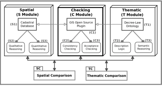
Figure 4.1: Conceptual Framework
As a result, the proposed framework (figure 4.1) should be capable to performSpatial comparison (SC) and Thematic comparison (TC) between cadastre polygons, retrieve the results and store information in the cadastral database.
4.2
Conceptual Framework
4.2.1
S Module
In order to ensure the data interoperability between distinct European Community in-stitutions, the remodelling of the existent municipal cadastral database based on theInspire Data Specification on Cadastral Parcels is proposed. These European guidelines can give sup-port on geometric data harmonisation according to the national vision, reality and governance (INSPIRE, 2009). With the idea to satisfy the research objectives and based on the munic-ipal and national future requisites, the proposed database model should satisfy the following requirements:
• Accept existent cadastral Spatial and Thematic entities;
• To be compliant withINSPIRE data specification on theme Cadastral Parcelsand LADM;
• Ensure that Spatial and Thematic attributes are compliant with defined and planned constraints.
The first requirement proposed a survey of the existing database classes (table 4.1) that should prevail in the model. Since the existent database just contains geometric cadastre of rustic property and the SiNErGIC project is not yet implemented, only the entities depicted in table. are considered in the new model.
Entity Description
Rustic Parcel Rustic areas represented in the municipal and national cadastral cartography.
Parish Administrative areas that contains rustic parcels.
Ownership Land registers information.
Table 4.1: Entities collected from the municipal cadastral database.
With the necessary entities compiled and explained, the basis for the second requirement is defined. From the INSPIRE cadastral parcel model derived from LADM (INSPIRE, 2009) (see appendix 3.), all entities are considered except the cadastralBoundary as depicted in appendix 4.a. This is due to the fact that the existent database only contains 2D entities and this research does not require a model with such complexity. Furthermore, the entity
cadastralZoningis simplified on the cadastral parish level.
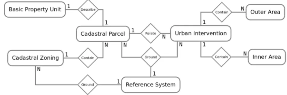
Taking into account that the rustic data is going to be store in the entity CadastralParcel, to fulfil entirely the third requirement, it is necessary to define how the urban data will be stored. As previously explained in the 2.3, only urban intervention projects are relevant for this research. When submitted to appreciation, the urban boundary is compared with the rustic boundary and the differences associated with this operation need to be stored. To guarantee this condition three entities are suggested: UrbanIntervention, OuterArea and InnerArea (see appendix 4.b).
Entity Description
Cadastral Parcel Rustic areas defined by cadastral registers or equivalent. a)
Basic Property Unit Unique ownership and homogeneous real property rights. b)
Cadastral Zoning Administrative areas used to divide the Municipality territory into cadastral parishes. a)
Reference System Coordinate reference system represented by an EPSG code. c)
Urban Intervention Interventions with urban purpose carried out in urban areas. c)
Outer Areas Areas of an urban intervention that overlay the neighbouring urban parcel. c)
Inner Areas The complement of an urban intervention area within the urban parcel. c)
a) Adapted fromINSPIRE data specification on theme Cadastral Parcels. b) Transcript fromINSPIRE data specification on theme Cadastral Parcels. c) Adapted from conventions adopted by municipality technicians.
Table 4.2:Entities considered in the proposed cadastral database model.
oneCadastral Parcelis described byone and only one Basic Property Unit
oneCadastral Parcelrelatesone or moreUrban Ontervention
oneUrban Onterventioncontainszero or more Outer Areas
oneUrban Onterventioncontainszero or more Inner Areas
oneCadastral Zoningcontainsone or moreCadastral Parcel
oneReference Systemgroundsone or more Cadastral Parcel
oneReference Systemgroundsone or more Urban Ontervention
oneReference Systemgroundsone or more Cadastral Zoning
Italic: Cardinality; Underline: Entity;Bold: Relationship
Table 4.3: Relationship description of the Entities of the proposed cadastral database model.
After assuring the four requirements, it is now possible to present the E-R model containing the entities and relationships (figure 4.2) discussed in the previous points.
Figure 4.2: E-R model of the proposed cadastral database.