PRELIMINARY RESULTS OF DRIFT-BOTTLE RELEASES AND RECOVERIES IN
THE WESTERN TROPICAL ATLANTIC
(Received in 25/10/1966)
ELLEN F. LUEDEMANN
Instituto Oceanográfico da Universidade de São Paulo
SYNOPSIS
In February-March 1963, during the Equalant Operation for the ICIT A pro-gram, 476 drift-bottles were released at the equatorial waters off the northern
Brazilian coast (OlOS to 09°N and 043°W to 053°W). Thirty-five. bottles were recovered (7,4%), Those were classed in five groups according to their different velocity ranges and areas of recovery (Trinidad Island; Lesser Antilles; Caribbean and Florida area; north Brazil; northeastern Brazil).
The recoveries of botUes released within 300 nm off the northern and north-eastern coast of Brazil confirmed a strong current along the north and northeast coast in northwestern direction (South Equatorial Current and branches). In late February-early March the botUes showed maximum velocities of this current
(3,6 knots).
The region off the northern coast of Brazil, between 05°N and 09°N up to 0500W seems to have been under the influence of an eastward component of the
surface current in this same period, while at late March this influence appears to have been weaker. In the region from Trinidad Island to Yucatan Peninsula the current seems to be stronger on the northeastern si de of the Caribbean Sea.
INTRODUCTION The present papel' reports the preliminary
results of the recoveries of drift bottles released during two cruises of the CT "Bertioga" to the Equatorial waters of northern Brazil undertaken as part of Equalant Operation ICITA programme, dur-ing February-March, 1963. A total of 476 bottles were released and 35 were recovered so faro Although the recoveries are rather limited, it is believed that their study may contribute to gain further knowledge of the surface currents of the region of North Brazil and the Caribbean Sea.
THE AREA STUDIED
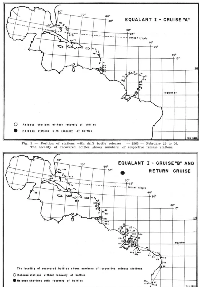
The st.ations at which bottles were released during cruise A and B were located oH the northern coast of Brazil in an area comprised approximately between 01°S and 09°N and 043°W and 053°W (Fig. 1 and 2). A total of 396 bottles were released during these two cruises, 10 at each station '''. When • With exception of station 11 where only 6 botUes were
released.
Publ. n.O 241 do Inst. Oceano da USP.
Bolm Inst. oceanogr. S Paulo, 16 (1) :13-22, 1967
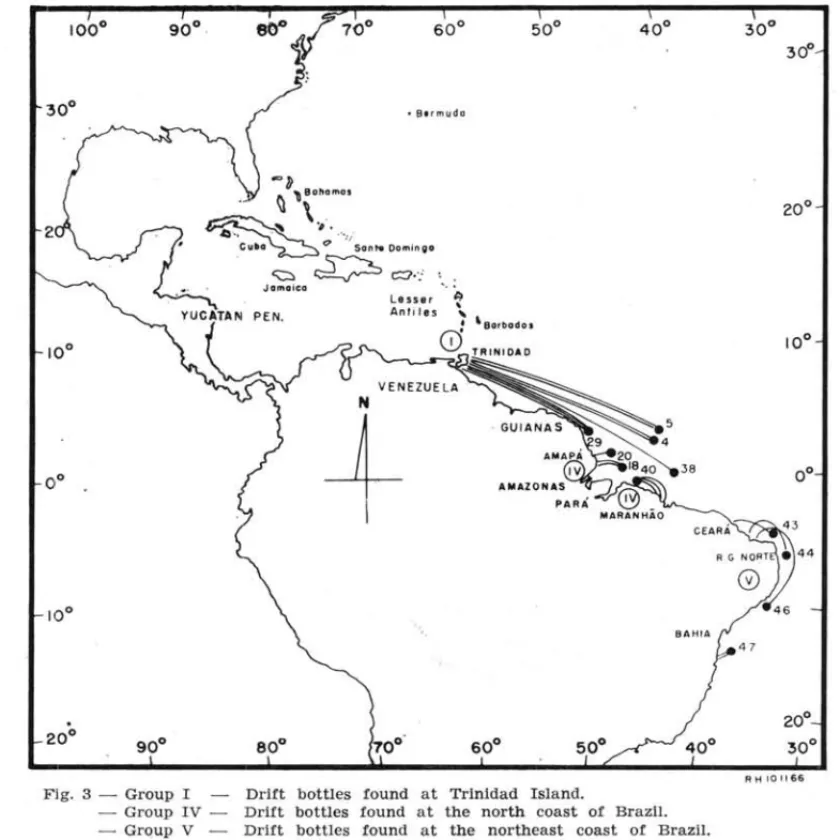
steaming southward after cruise 13 another 80 Loltles were released at stations situated oH the northern and northeastern coasts of Brazil, covering lhe area between 02°S and 17°S and 0400W and 035°W
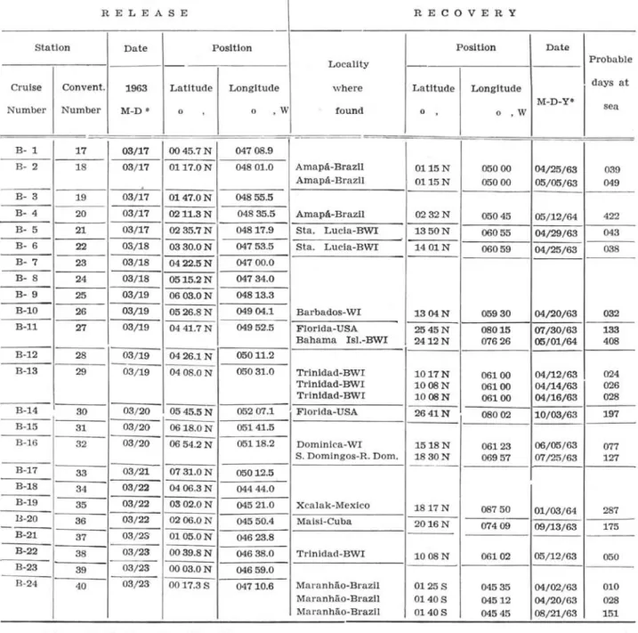
(Fig. 2). On Figures 1-5 we have used a conven-tional successive numeration for alI stations (48) from which drift bottles were released. Instead of draw-ing the probable routes of the recovered drift bottles on the maps, we preferred to identify the places of recovery with the same number as that of the res-pective release station. Tables VIa, VIb, and VIc give the date of release and recovery.
The literature concerning the investigated are a describes it as folIows: the current system of this area is essentialIy a continuation of lhe strong North and South Equatorial Current System. It is defined by DIETRICH & KALLE (1957) as a region of tradewind currents. From December to about Iate February, when cruise A was carried out, the norlhern trade wind system attains in that area its southernmost limit from about 01°N and 0300W up to abollt
07°N and 0500W, oH lhe northern coast of Brazil
up to the Guiana coast. The northern limit of the southeast trades runs approximately along the
60·
30·
EQUALANT
I - CRUISE "A"
~==~t---
~ ----~--
--~--~~r:~
f.. 2~O
cancer t.r opic
• qu a I r
o
Rtllasa slallons wlt hou l recov"y 01 bottles• Rel.ou slal ion s wlth .. covery pl bottl u
2
~.,.I."
Fig. 1 - Position or stations with drift botUe releases - 1963 - February 19 to 26. The locality or recovered botUes shows numbers or respective release stations.
EQUALANT
I - CRUISE "B" ANO
60· 30·
•
,---!r---1----r--__
~~0·L 2~·
- - - - conel( rrop ic
The locoll', oi recovered botlle. show, num"" 01 respectl" re leose s'ollon5
o
Rele ... slollons w"hou' recover, 01 botlle • • Releo.e .Iottonl w"h reeo .. r, oi botll ••RETURN CRUISE
• ua t o
••
• s
".n u'M
tor up to the Guiana-Brazilian coast. Between these trade wind regions there usualIy is a zone of variable width, the so calIed equatorial calms or the doldrum beIt (YZAL, 1960; RODEN, 1962) _
Furthermore in March the southeast trades cross the Equator and invade the northeastern and northern area off the coast of Brazilup to the Guiana-Brazilian coast (op. -:it.).
According to PARR (1937), the stress exerted on the surface waters between the Lesser AntilIes and the Yucatan ChanneI by the prevailing easterIy winds produces a piling up of waters in front of this narrow channel. According to DIETRICH & KALLE
(1957), the Florida Current is mainly a direct conti-nuation of the current through the Yucatan Channel. Since the waters of the GuIf of Mexico form in de-pendent eddies only a smalI fraction enters the Flo-rida Current (DIETRICH, 1939; DIETRICH & KALLE, 1957). Numerous eddies are present also on the fIanks of the ma in current of the Caribbean Sea, f. insto between Nicaragua and Colombia and
bet-ween Jamaica and Cuba (SVERDRUP et al., 1955). Such are, in accordance with that literature, the conditions of the area studied which may give an idea of the numerous infIuences to which drift bottles are exposed, mainly on their longer routes;
""lJ l\ '\ Bahamos
.- \I \
~
,
....
- . c"'~ t;J ' sont. OomlnljlO
~
~c:J.:
in addition to these they are exposed to accidental factors, such as storms, tropical cycIones, waves and so on.
RESULTS
The stations of cruise A (1-16) and B (17-40) from which bottles were recovered, are located within an area of about 300 nm off the northern Brazilian coast (Fig. 1 and 2). Out of the 396 bottles re-leased, 28, or 71%, were recovered. No bottles
re-leased in February from stations between 05°N and 09°N (Fig. 1) were recovered; however, a few recoveries were obtained from bottles released there in March (Fig. 2). AlI bottles recovered, except those from station 40 (Fig. 2), drifted in north-western or north-northnorth-western direction. Out of the 80 bottles released after cruise B "Return Cruise" (stat. 41-48), seven, or 8,7'%, were recovered. They foIlowed the same direction as mentioned above except for two bottles, released at 16°S and 038°W (stat. 47) which reached the State of Bahia, Brazil. The recovered bottles are cIassed in five groups, according to the area of recovery and to their diffe-rant ranges of velocity (Tab. I-V; Fig. 3-5).
Jamaica
Les .ser ~ Antlles '"
: 'Barbado.
o
TRINIDAOPEN.
N
+
CEARÁ~3
R G G;T .44
46
47
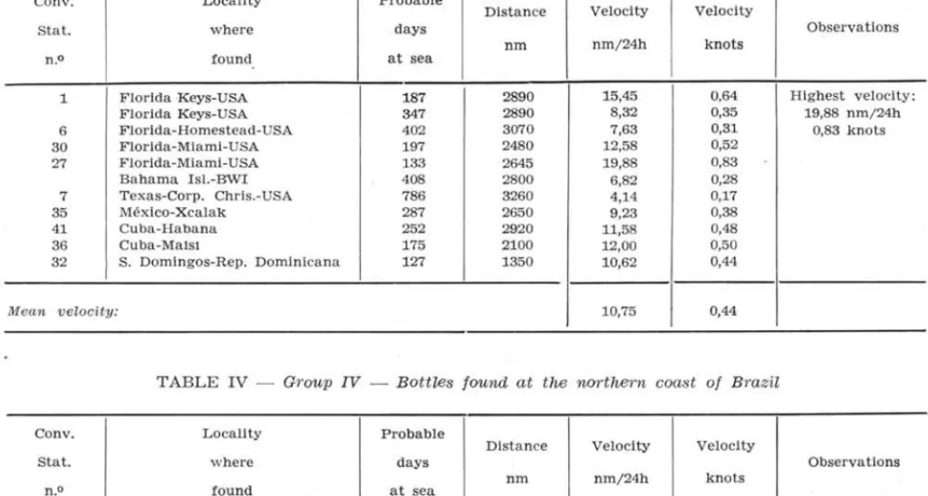
Fig. 3 - Group I Drift botUes found at Trinidad Island.
- Group IV - Drift botUes found at the north coast of BrazU. - Group V - Drift botUes found at the northeast coast of Brazil.
GROUP I: Isle of Trinidad - The bottles
reçovered showed velocity ranges from 20,8 to 87,16 nm/24 hr, with a mean value of 52,0 nm per day or 2,2 knots (Tab. I; Fig. 3).
TABLE I - GrO'Up I - Bottles 'ound at Trinidad Island
Conv. Locality Probable Dlstance Veloclty Veloc1ty
Stat. where days Observatlons
n.O at sea
fqund nrn nrn/24h knots
4 Trlnldad Island-BWI 12 1020 85,00 3,54 Hlghest veloclty:
5 Trlnldad Island-BWr 12 1046 87,16 3,60 87,16 nrn/ 24h
Trinldad Island-BWr 12 1046 87,16 3,60 3,60 knots
29 Trlnidad Island-BWI 24 720 30,05 1,25
Trinidad Island-BWI 26 720 27,69 1,15
Trinidad Island-BWI 28 720 25,72 1,07
38 Trinidad Island-BWI 50 1046 20,80 0,87
Mean veloci ty: 52,0 2,2
o
30
2
BA H I A
GROUP lI: Lesser AntilIes - The velocity of the
recovered bott!es ranged from 10,3 nm/ 24 h to 25,7 nm/ 24 h. The mean value wos about 17,55 nm/24 h or 0,73 knots (Tab. lI; Fig. 4).
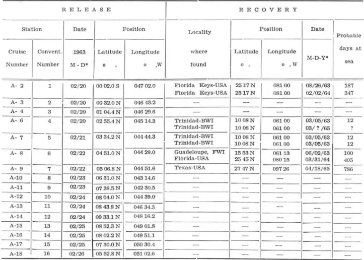
GROUP 11I: This group includes bottles which
apparently have followed the Caribbean and Florida
Currents with velocities ranging from 4,14 nrn/24 h to 20,0 nm/24 h with a mean value of 10,8 nm per day or 0,44 knots (Tab. 11I). Fifty five percent of these bottles drifted to the Florida area, while others were recovered in different places of the Caribbean Sea (Tab.
IH;
Fig. 5).T ABLE II - Group II - Bottles lound at tM Lesser Antilles
Conv. Locality Probable
Distance Velocity Veloclty
stat. where days Observations
nm nm/24h knots
n.O found at sea
6 Guadeloupe-FWI. 100 1220 12,20 0,51
I
Highest v elocity:
21 Sta. Lucia-BWI. 43 995 23,13 0,96 25.65 nm/ 24h
22 Sta. Lucla-BWI. 38 975 25,65 1,07 1,07 knots
26 Barbados-BWI. 32 755 23,59 0,98
41 Barbados-BWI. 123 1290 10,48 0,44
32 Domlnlca-BWI. 77 790 10,26 0,43
Mean veZocity: 17,55 0,73
Bumudo
2
2 0-; '. '
---~~~,.. Pu.rfoR ico· ~ Lesser Antilles
•
?
oBarbados
BAHIA
R"H"9' 166 Fig. 5 - Group IH - Drift bottles tound at the Caribbean and Florida area.
T ABLE III - Group III - Bottles found within the Caribbean and Florida area
Conv. Locality Probable
Distance Velocity Velocity
Stat. where days Observations
nm nm/24h knots
n.O found at sea
1 Florida Keys-USA 187 2890 15,45 0,64 Highest velocity:
Florida Keys-USA 347 2890 8,32 0,35 19,88 nm/24h
6 Florida-Homestead-USA 402 3070 7,63 0,31 0,83 knots
30 Florida-Miami -U SA 197 2480 12,58 0,52
27 Florida-Miami-USA 133 2645 19,88 0,83
Bahama Isl.-BWI 408 2800 6,82 0,28
7 Texas-Corp. Chris.-USA 786 3260 4,14 0,17
35 México-Xcalak 287 2650 9,23 0,38
41 Cuba-Habana 252 2920 11,58 0,48
36 Cuba-Mais! 175 2100 12,00 0,50
32 S. Domingos-Rep. Dominicana 127 1350 10,62 0,44
Mean velocity: 10,75 0,44
T ABLE IV - Group IV - Bottles found at the northern coast of Brazil
Conv. Locality Probable
Distance Velocity Velocity
Stat. w here days Observations
nm nm/24h knots
n.O found at sea
40 Maranhão-Brazil 10 100 10,00 0,42 Highest veloclty:
Maranhão-Brazil 28 100 3,60 0,15 (Maranhão) ;
Maranhão-Brazil 151 100 0,66 0,03 10,00 nm/24h
0,42 knots
18 Amapâ-Brazil 39 210 5,38 0,22 Hlghest velocity;
Amapâ-Brazll 49 210 4,28 0,18 (Amapâ);
20 Amapâ-Brazil 422 125 0,29 0,01 5,38 nm/24h
0,22 knots
Mean velocity (Maranhão) ; 4,75
I
0,20Mean velocity
.
(Amapâ) ; 3,32 0,14TABLE V - Group V - Bottles found at the northoostern coast of Brazil
Conv. Locallty Probable
Stat. where days
n.o found at sea
43 Cearâ-Brazil 21
44 Cearâ-Brazil 20
46 Rio Grande do Norte-Brazll 46
Mean velocity:
GROUP IV: Northern Brazil - Bottles released
lU front of the mouth of Pará and Amazonas rivers were recovered at Maranhão and Amapá. The bottles that drifted to Maranhão, from station 40, showed a velocity range from 0,66 nrn/24 h (151 days at sea!) to 10,0 nrn/ 24 h. The velocities of the boUles found at Amapá, released at stations 18 and 20, showed the lowest values of all, ranging
Dlstance Velocity Veloclty
Observations
nm nm/24h knots
260 7,60 0,32 Highest velocity:
220 11,00 0,46 11,00 nm / 24h
380 8,20 0,34 0,46 knots
8,93 0,37
from 0,29 nm/ 24 h (422 days at sea!) to 5,4 nm/ 24 h (Tab. IV; Fig. 3).
GROUP V: Northeastern Brazil - The bottles
TABLE VI a - CRU/SE A
RELEASE RE COVERY
-
--Station Date Position Locality Position Date
I
Probable
-Cruise Convento 1963 Latitude Longitude where
I
Latitude Longitude days atM-D-Y*
Number Number M-D* o , o ,W found o , o ,W sea
I
A- ::/ 1
I
02/20 0002.0 S 04702.0 Florida Keys-USA 2517N 08100 08/26/63 187
Florida Keys-USA 2517N 08100 02/02/64 347
A- 3 2 02/20 00 32.0 N 04643.2 -
-
-
---- -
-A- 4 3 02/20 0104.4N 04629.6 -
-
-
--A- 6 4 02/20 0255.4N 04514.3 Trinidad-BWI 1008N 06100 03/05/63 12
Trinidad-BWI 1008N 06100 03/? /6S ?
-_._-A- 7 5 02/21 0334.2 N 04444.3 Trinldad-BWI 1008N 06100 03/05/63 12
Trinidad-BWI 1008N 06100 03/05/63 12
A- 8 6 02/22 0451.0N 04429.0 Guadeloupe, FWI 1553N 06113 06/02/63 100
Florida-USA 2545N 08015 03/31/64 40S
A- 9 7 02/22 0506.8 N 04451.6 Texas-USA 2747N 09726 04/18/65 786
A-lO 8 02/23 0631.0 N 04314.6
A-ll 9 02/23 0738.5N 04230.5
-A-12 10 02/24 08 04.0 N 04439.0
A-13 11 02/24 0843.8 N 04634.S
A-14 12 02/24 0933.1N 04816.2
A-15 13 02/25 0852.3N 04901.8
A-16 14 02/25 0802.2 N 04951.1
A-17 15 02/25 0730.0N 05030.4
A-18 16 02/ 26 0552.8 N 05102.6
• M Month; D :=: Day; Y Year. DISCUSSION
The fact that no recovery was obtained from the bottles released at 9 stations (8 - 16) from cruise A, within the area of about 05°N - 09°N and from about 043°W - 051°W, seems to confirm the presence of an eastward component of the sur-face current (NEUMANN, 1960; 1965; COéHRANE, 1963) .
On the other hand, the recovery oí 9 bottles (181%) out oí those la unched, at the same time, at 5 stations situated in the area about the Equ::tor up to 05°N and 043°W to 047°W (Fig. 1) confirhl, with their results, the existence of a strong current along the north coast oí Brazil within a zone of 300 nm in the northwestern direction (Guiana Current).
During cruise B, one month later, 7 stations were located in approximately the same area about 05°N up to 08°N and from about 045°W to 052°W (stat. 24-26; 30-33) . From these only 4 bottles (5,7%) were recovered. However, from 17 stations located between the Equator and 05°N and from about 045° to 052°W (stat. 17-23; 27-29; 34-40) 16 bottles (9,4%) were recovered (Fig. 2). This suggests that the eastward component of the surface current may have been more developed in February than in March in the first area mentioned, while later on drift currents produced by the trades might Bolm Inst. oceanogr. S Paulo, 16 (1) :13-22, 1967
- - -
-
-
--- - - - -- --
---
- - -- - - - -- --
- -- - - --I
--
- -- --
--have been the dominant ones (NEUMANN 1960, p. 334) .
The first bottles returned from Trinidad Island showed the highest speeds (Tab. I) . The very high velocity of more than 85 nm per day or 3,5 knots (3 bottles out of 7 recoveries) may be explained by the information received that the days before the recovery, early March 1963, had been stormy. Com. pare, for example, the velocity of 2,8 knots found by KEEN & CHIMIAK (1955) in the Caribbean sea. The bottles recovered at the Lesser Antilles prov-ed that the strong current observprov-ed oH the north Brazilian coast reached that area. The greatest velo-city in the Lesser Antilles area is that developed by the bottle which stranded at St. Lucia Island with about 26 nm per day or 1,1 knots in April 1963 (Tab. 11).
KEEN & CHIMIAK (1955) showed the presence of a northeastern surface current through the Wind-ward Passage, which explains the recovery of a bottle at Maisi, Cuba. (Fig. 5; Table
111).
Out of the group of bottles which reached the Florida area (Tab.
111;
Fig. 5), the fastest was one that ran from the north coast of Brazil to Miami (-+- 2650 nm) in 133 days, with an average speed of 20 nm per day or 0,83 knots. However, the long-est route seems to have been that oí 3. bottle,TABLE VI b - ORUISE B
RELEASE RE COVERY
Statlon Date Posltlon Posltlon Date
Locallty Probable
--Crulse Convento 1963 Latitude Longitude where Latitude Longitude days at
M-D-Y' sea
Number Number M-D • o , o ,W found o , o ,W
B- 1 17 03/17 00 45.7 N 04708.9
I
B- 2 18 03/17 0117.0N 04801.0 AmapA-BrazU 0115N 05000 04/25/63 039
AmapA-Brazil 0115N 05000 05/05/63 049
.
B- 3 19 03/17 0147.0N 04855.5
B- 4 20 03/17 0211.3N 04835.5 AmapA-Brazll 0232 N 05045 05/12/64 422
B- 5 21 03/17 0235.7 N 04817.9 Sta. Lucia-BWI 1350N 06055 04/29/63 043
B- 6 22 03/18 0330.0N 04753.5 Sta. Lucla-Bwr 1401N 06059 04/25/63 038
B- 7 23 03/18 0422.5N 04700.0
B- 8 24 03/18 0515.2N 04734.0
----B- 9 25 03/19 0603.0N 04813.3
B-I0 26 03/19 0526.8N 04904.1 Barbados-WI 1304N 05930 04/20/63 032
B-ll 27 03/19 0441.7N 04952.5 Florida-USA 2545N 08015 07/30/63 133
Bahama Isl.-BWI 2412N 07626 05/01/64 408
B-12 28 03/19 0426.1 N 05011.2
-B-13 29 03/ 19 0408.0 N 05031.0 Trinidad-BWI 1017N 06100 04/12/63 024
Trinldad-BWI 1008N 06100 04/14/63 026
Trinldad-BWI 1008N 06100 04/16/63 028
----B-14 30 03/20 0545.5N 05207.1
- - - -
Florida-USA 2641N 08002 10/03/63 197B-15 31 03/ 20 0618.0N 05141.5
B-16 32 03/20 0654.2 N 05118.2 Dominica-WI 1518N 06123 06/05/63 077
S. Domingos-R. Dom. - - --1830N 06957 07/25/63 127
B-17 33 03/21 0731.0N 05012.5
B-18 34 03/22 0406.3 N 04444.0
B-19 35 03/22 0302.0N 04521.0 Xcalak-Mexico 1817 N 08750 01/03/64 287
13-20 36 03/22 0206.0N 0455004 Maisi-Cuba 2016N 07409
09/13/63 175
----
B-2137 03/ 2S 0105.0N 04623.8
B-22 38 03/23 0039.8N 04638.0 Trinidad-BWI 1008N 06102 05/12/63 050
B-23 39 03/23 0003.0N 04659.0
B-24 40 03/ 23 0017.3 S 04710.6 Maranhão-Brazll 0125 S 04535 04/02/63 010
Maranhão-Brazl1 0140S 04512 04/20/63 028
Maranhão-Brazil 0140S 04545 08/21/63 151
• M
=
Month; D=
Day; Y=
Year.ched at station 7, which reached Texas (Corpus Christi) in the Gulf of Mexico (3260 nm) in 786 days. (Fig. 5). The cause of the Iong time spent at sea may be the large eddies which are formed in the Gulf of Mexico, a common feature of this area
(DIETRICH, 1939); also that it had been released in
lhe area where the eastward component seems to predominate at the time of release.
after 347 days with a mean velocity of only 8,3 nm per day or 0,35 knots. KARWOSKI (1963) refers
that drift bottles are moved by waves in different directions. However the fact mentioned above suggests that although influenced by waves, the force of the ma in current predominates. It is possible that the second bottle drifted around the Gulf of Mexico before stranding at the Florida Keys.
The bottles which performed the longest routes might have been exposed to the effect of different factors such as wind, waves, eddies etc. Therefore it is difficult to have an idea of the real velocity of the current. Two bottles, f. example, of the same station 1 reached the same locality, Florida Keys (Fig. 5); one after 187 days with an average velo-city of 15,5 nm per day or 0,64 knots and the other
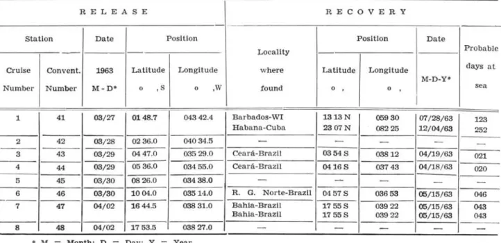
TABLE VI c - RETURN CRUISE
RELEA8E RECOVERY
8tatlon Date Position Positlon Date
--
- - Locality ProbableCruise Convento 1963 Latitude Longitude where Latitude Longitude days at
M-D-Y*
Number Number M-D* o , S o ,W found o o , sea
I
1 41 03/27 0148.7 04342.4 Barbados-WI 1313N 05930 07/28/63 123
Habana-Cuba 2307N 08225 12/04/63 252
2 42 03/28 0236.0 04034.5
-
-
-
-
-3 43 03/29 0447.0 03529.0 Cea rá-Brazll 03548 03812 04/19/ 63 021
4 44 03/29 05 36.0 03455.0 Ceará-Brazil 04168 03743 04/18/ 63 020
5 45 03/30 0826.0 03438.0 -
-
- --6 46 03/30 1004.0 03514.0 R. G. Norte-Brazil 04578 03653 05/15/63 046
- -
--7 47 04/02 1644.5 038 31.0 Bahla-Brazil 17558 03922 05/15/ 63 043
Bahia-Brazil 17558 03922 05/15/63 043
8 48 04/02 1753.5 03827.0
• M
=
Month; D=
Day ; Y=
Year.in that direction (Fig. 3). The higher velocities of the bottles of the northeastern Brazil group seems to confirm the presence of the stronger South-Equatorial Current (Fig. 3).
No recoveries were reported from the northern coast of South America and the eastern coast of Central America, from Trinidad Island up to the southeastern Yucatan, Mexico. This indicates that the current is strongest on the northeastern si de of the Ciuibbean Sea which is in a good agreement with the action of Corioli's force. But we remember the smalI material and the smalI density of the human population on the mentioned coast (Fig. 3-5).
CONCLUDING REMARKS
1 - The recoveries of drift bottles from stations located as far as 300 nm oH the northern coast of Brazil confirm the presence of a strong current in a north-western direction. This current as welI as that present along the eastern coast of Brazil, also confirmed by the bottle released oH the coast
oI
Maceió (10004'S - 035°14'W) and recovered on the northeast coast (Tab. V) , are believed to represent branches of the South Equatorial Current.
2 - The bottles reIeased about 140 nm in front
oI
the mouth of Amazonas river suggest a slow drift current along the coast oI Amapá. Those released near the mouth of the Pará river, are the only ones which drifted southeastward along the coast, they suggest a somewhat faster coastal current to Mara-nhão (Fig. 3).3 - Several recoveries of bottles at Trinidad Island showed clearly the eHect of the strong Guiana Current: its mean velocity in March and April was about 2,2 knots as evaluated by the traveI velocity
oI
the bottles. Very strong winds (storm) in the Bolm Inst. oceanogr. 8 P a ulo, 16(1) :13-22, 1967-
-
-
-
-first days of March may be responsible for an apparent increase of velocity, to an estimated 3,6 knots.
4 - The recoveries at Lesser AntilIes confirm the penetration
oI
the South Equatorial Current through that area into the Caribbean Sea. The greater part of the bottles and the fastest reached the area in April. One of them drifted with a velo-city of 25,6 nm per day or 1,1 knots.5 - After having drifted a probable route of more than 2600 nm one bottle reached Miami with an average speed of 20 nm per day or 0,83 knots. The mean velocity value for alI bottles concerning the Caribbean and Florida area was 10,8 nm per day or 0,4 knots.
6 - The region oH the northern coast of Brazil, between about 05°N and 09°N and extending to the West up to 0500W, seems to have been during late February under the influence of an eastward compo-nent of the surface current; this fact would in part explain the complete lack of recovery of bottles out
oI
90 which were launched within this area. This influence seems to have been weaker during cruise B in late March. The bottle which was found after more than two years (786 days) in Texas had been released late February at a station just within the limits of the area mentioned above (stat. 7: 05°06'N-044°51'W) .7 - The recoveries of bottles show that the current seems to be stronger on the northeastern side of the Caribbean Sea.
ACKNOWLEDGEMENTS
EMÍLSSON, the scientist in charge during the Equa. lant I Operation, who organized alI the work concern· ing the reIease of bottles and for permitting the use of the present data. The work at sea was executed by members of the staíf of the Physical Section, and by the officers and the cre'W of the "CT Bertioga". I am much indebted aIs o to Dr. LILIANA FORNERlS for worthful advices and heIpful criticism. To Dr. ARGEO MAGLIOCCA, Director of the Physical Divi· sion, my thanks for facilities given. Many thanks are due to the Director of the Institute, Dr. MARTA VANNUCCI, for criticisms and reading of the ma nus· cript. I wish to extend my thanks also to Dr. REJDAR LEINEBO for his kind appreciation and helpfuI sugges· tion. The drawings were made by Mr. RENATO HERZ.
SUMARIO
Em fevereiro-março de 1963 foram lançadas 476 garrafas de deriva diante das costas norte e nordeste do Brasil durante a Operação Equalant para o pro-grama ICITA; destas foram recuperadas até agora 35.
Estas foram classificadas em cinco grupos con-forme a sua área de encontro e segundo as variações de velocidade do percurso.
GRUPO I - Ilha de Trinidad - As garrafas re-cuperadas apresentavam variações de velocidade entre 20,8 a 87,16 mn/ 24 h com um valor médio de 52,0 mn por dia ou 2,2 nós (Tab. I).
GRUPO II - As pequenas Antilhas - A velocidade das garrafas recuperadas variaram de 10,3 mn por dia a 25 mn por dia. O valor médio esteve ao redor de 17,55 mn por dia ou 0,73 nós (Tab. II).
GRUPO III - Mar dos Caraibas e Florida - ~ste grupo compreende garrafas que aparentemente acom-panharam as Correntes das Caraíbas e da Flórida com velocidades que variaram de 4,14 mn por dia a 20 mn por dia com uma velocidade média de 10,8 mn por dia ou 0,44 nós (Tab. II!). Cêrca de 50% dessas garrafas convergiram para a área da Flórida enquanto que ou-tras foram encontradas em diferentes locais do Mar dos Caraíbas (Tab. II!).
GRUPO IV - Norte do Brasil - Compreende as garrafas lançadas diante das desembocaduras dos rios Pará e Amazonas. As garrafas que chegaram ao Ma-ranhão, da estação 40, apresentaram uma velocidade entre 0,66 mn por dia (151 dias no mar) e 10,0 mn por dia e foram as únicas que derivaram em direção su-deste. As velocidades das garrafas encontradas no Amapá, lançadas nas estações 18 e 20, representam os valores mais baixos de todos, variando entre 0,29 mn por dia a 4,4 mn por dia (Tab. IV).
GRUPO V - Nordeste do Brasil - As garrafas fo-ram lançadas durante o cruzeiro de retôrno diante das costas do nordeste do Brasil. A variação de velocidade dêste grupo vai de 7,6 mn por dia para 11,0 mn por dia, com um valor médio de 9,0 mn por dia ou 0,4 nós (Tab. V).
Com exceção das garrafas da estação 40 que deri-varam em direção sudeste, tôdas as outras foram en-contradas a noroeste do seu local de lançamento.
REFERENCES CoCHRANE, J. D.
1963. Equa torial undercurrent and rela ted currents off Brazil in March and April, 1963. Science, voI. 142, n.o 3593, p. 669-671.
DIETRICH, G.
1939. Das amerikanische Mittelmeer. Z. Ges. Erdk. BerI., p. 108-130. Cito in Sver-drup, H. U. et aI. The oceans, p. 642. DIETRICH,
1957.
G. & KALLE, K .
Allgemeine Meereskunde. Berlin, Ge-brüder, Borntdiger.
HERNANDEZ, Y. S.
1960. Tratado de meteorologia nautica. Bar-celona, Garriga, 475 p.
KARWOSKI, J.
1963 . Measurement of sea currents by means of drift bottles. Int. hydrogr. Rev., voI. XL, n.o 2, p. 119-123.
KEEN, J. & CHIMIAK, W.
1955. Caribbean current survey. Tech. Rep. hydrogr. Off., Wash. Tr-1'2, 14 p. NEUMANN, G.
1960.
1965.
PARR, A. E. 1937.
RODEN, G.
r.
1962.
Evidence for an equatorial undercurrent in the Atlantic Oceano Deep Sea Res., voI. 6, n.o 4, p. 328-334.
Oeanography of the tropical Atlantic. Anais Acad. bras. Ciênc., vol. 37, supI., p. 63-82.
A contribution to the hydrography of the Caribbean and Cayman seas based upon the observations made by the re-search ship "Atlantis", 1933-34. BulI. Bingham oceanogr. Coll., voI. 5, art. 4, 110 p. Cito in Sverdrup, H. W., et
aI., The Oceans, p. 641.
On sea-surface temperature, cloudiness and -wind variation;; in the Tropical Atlantic. J. Atmos. Sei., voI. 19, n.o 1, p. 68.
SVERDRUP, H. U., JOHNSON, M. W ., FLEMING, R. H. 1955. The Oceans. 6th ed. N~w Jersey,
Pren-tice HalI.
U. S.-NAVY