Journal of Coastal Research Manuscript Draft
Manuscript Number: JCOASTRES-D-09-00114
Title: Variations in tidal constituents along the nearshore waters of Karnataka, west coast of India Short Title: Tidal constituents along nearshore of Karnataka, west coast of India
Article Type: Research Article (Professional Paper)
Keywords: Harmonic constants; tidal heights; sea level; atmospheric forcing; Karnataka coast; Arabian Sea
1 2 3 4 5 6 7 8 9 10 11 12 13 14 15 16 17 18 19 20 21 22 23 24 25 26 27 28 29 30 31 32 33 34 35 36 37 38 39 40 41 42 43 44 45 46 47 48 49 50 51 52 53 54 55 56 57
Variations in tidal constituents along the nearshore waters of Karnataka, west
coast of India
V.Sanil Kumar, G. Udhaba Dora, Sajive Philip, P.Pednekar and JaiSingh
Ocean Engineering, National Institute of Oceanography (Council of Scientific & Industrial Research), Dona Paula, Goa - 403 004 India
Abstract
Based on the sea level data measured using the Valeport wave and tide gauge during the pre-summer monsoon period at 3 locations along the nearshore waters of Karnataka, west coast of India, the characteristics of tidal constituents are described. The objective of the study is to identify the tidal and non-tidal variations along the coast. Analysis shows that the astronomical tides are responsible for most of the observed sea level variability along the Karnataka coast with 97% of the variation in measured sea level at Honnavar and Malpe due to tide and 96% of the sea level variation at Kundapur due to tide. The observed non-tidal sea levels were related with the local wind forcing. The study shows that when the wind from south was strong, a rise in sea level was observed and when the wind from north was strong, a fall in sea level was observed. Correlation between alongshore component of wind and non-tidal sea level was 0.54 at Malpe and 0.48 at Honnavar. The non-tidal sea level variation was found to vary according to the significant wave height with high residuals of sea level found during high waves. Shallow water constituents are found to amplify more compared to other constituents from south to north along the study area.
Key Words: Harmonic constants, tidal heights, sea level, atmospheric forcing, Karnataka coast, Arabian Sea
Manuscript
1 2 3 4 5 6 7 8 9 10 11 12 13 14 15 16 17 18 19 20 21 22 23 24 25 26 27 28 29 30 31 32 33 34 35 36 37 38 39 40 41 42 43 44 45 46 47 48 49 50 51 52 53 54 55 56 57 58
1. Introduction
Information on tides along the coast is important for estimating the tide induced currents and planning the shoreline management plans. The tide gauges record water level that is the sum of astronomical tides and fluctuations due to currents and meteorological events. Tidal propagation in the Gulf of Khambhat and surrounding areas was studied by Unnikrishnan et al. (1999) and Nayak and Shetye (2003). The amplification of semidiurnal constituents of tides in the Gulf of Kutch was studied by Shetye (1999). Srinivas et al. (2003) studied the propagation of tides in the Cochin estuary. Sundar and Shetye (2005) studied the tides in the Mandovi and Zuari estuaries. Tides off Karnataka coast are not studied in detail. Hence we have examined the variations of the tidal constituents covering 100 km distance along the Karnataka coast, west coast of India based on simultaneously measured sea level data at 3 locations for 30 days period during March-April 2008. The objective of the study is to identify the tidal and non-tidal variations in sea level along the Karnataka coast and study the influence of atmospheric forcing on sea level.
1.1 Study area
1 2 3 4 5 6 7 8 9 10 11 12 13 14 15 16 17 18 19 20 21 22 23 24 25 26 27 28 29 30 31 32 33 34 35 36 37 38 39 40 41 42 43 44 45 46 47 48 49 50 51 52 53 54 55 56 57
1.06 m in September to 1.3 m in January. Based on the Indian Tide Table, the average tidal range at Karwar is 1.58 m during spring tide and 0.72 m during neap tide.
2. Materials and methods
Valeport Tide gauge (Valeport Limited, UK) was deployed to collect the hourly sea level data at locations C1, C2, C3 and C4. The Valeport tide gauge at location C4 was towed away from the moored location by fishing vessels and could not be traced at the moored location and hence the data could not be recovered.
The measured sea level data was subjected to harmonic analysis to determine the amplitudes and phases of the tidal constituents (Emery and Thomson, 1998; Pugh, 1987). Tidal analysis was carried out using standard harmonic method, where a finite set of cosine functions with frequencies at the known astronomical forcing frequencies were fitted to the data using the least square method. Tidal Analysis Software Kit, TASK (Bell
et. al., 2000) developed by the Proudman oceanographic laboratory, UK was used for the analysis. Analysis was done with 24 independent constituents and 8 related constituents recommended for one month data of tides and currents. Removal of tidal component from the sea level data leaves residuals of sea level that include contributions from direct wind forcing, indirect wind forcing and surface waves (Prandle, 1997).
Reanalysis data of zonal and meridional components of wind speed at 10 m height at 6 hourly intervals from NCEP / NCAR (Kalney et.al., 1996) was obtained for the point (12.5º N; 72.5 º E) close to the study area to know the influence of wind on sea level. These data are provided by the NOAA-CIRES Climate Diagnostics Center, Boulder, Colarado at http://www.cdc.noaa.gov/. Relationship between wind forcing and residuals of sea level
1 2 3 4 5 6 7 8 9 10 11 12 13 14 15 16 17 18 19 20 21 22 23 24 25 26 27 28 29 30 31 32 33 34 35 36 37 38 39 40 41 42 43 44 45 46 47 48 49 50 51 52 53 54 55 56 57 58
3. Results and discussion
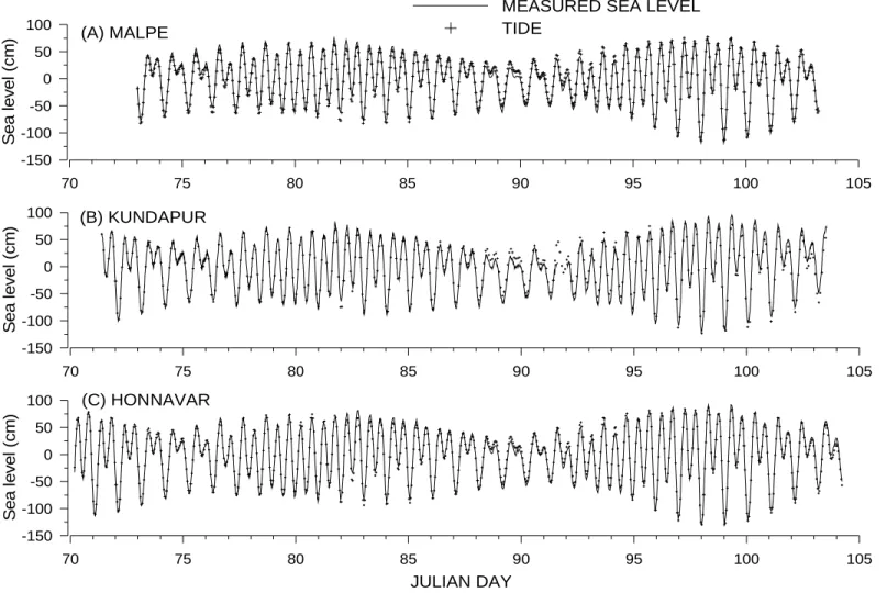
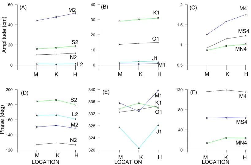
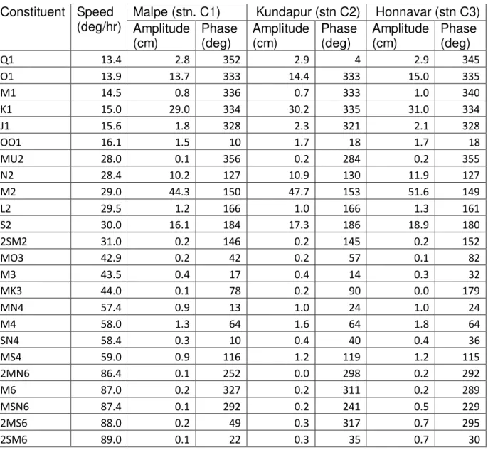
The maximum tidal range during the measurement period was 1.8, 1.9 and 2.1 m at Malpe, Kundapur and Honnavar (Figure 2). As expected an increase in tidal amplitude from South to North along the coast was observed. Predominant tidal constituents were M2, S2, N2, K1, O1, Q1, J1 and M4 with constituent M2 (0.0805 cph) having the highest magnitude followed by K1 (0.0418 cph) constituent (Table 1). The form number, which is the ratio of the sums of the amplitudes of the diurnal constituents (K1 and O1) to that of the semidiurnal constituents (M2 and S2) is 0.71, 0.69 and 0.65 at Malpe (stn. C1), Kundapur (stn. C2) and Honnavar (stn. C3). The tides are thus classified as mixed and predominantly semidiurnal in nature. The mean spring tide range i.e., 2(M2+S2) is 1.21, 1.3 and 1.41 m at Malpe, Kundapur and Honnavar and the mean neap tide range is 0.56, 0.61 and 0.66 m. Form number is found to increase from the north to the south along the coastline. Srinivas and Dineshkumar (2002) found the form number to be 0.80 for Beypore which is 270 km south of Malpe. The major tidal constituents are found to increase from south to north (Figure 3). The amplification of tidal constituent M2 and S2 is 1.17 (Figure 3a) from Malpe to Honnavar, whereas the amplification of K1 is 1.07 and that of O1 is 1.09 (Figure 3b). Shallow water constituents are found to amplify more compared to other constituents (Figure 3c). The amplification of M4 was 1.39 and that of MS4 is 1.33 from Malpe to Honnavar. The total contribution of diurnal constituent was found to decrease from 38 at Malpe to 36% at Honnavar, whereas the contribution of semi-diurnal constituents was found to increase from 56.7% at Malpe to 57.8% at Honnavar.
1 2 3 4 5 6 7 8 9 10 11 12 13 14 15 16 17 18 19 20 21 22 23 24 25 26 27 28 29 30 31 32 33 34 35 36 37 38 39 40 41 42 43 44 45 46 47 48 49 50 51 52 53 54 55 56 57
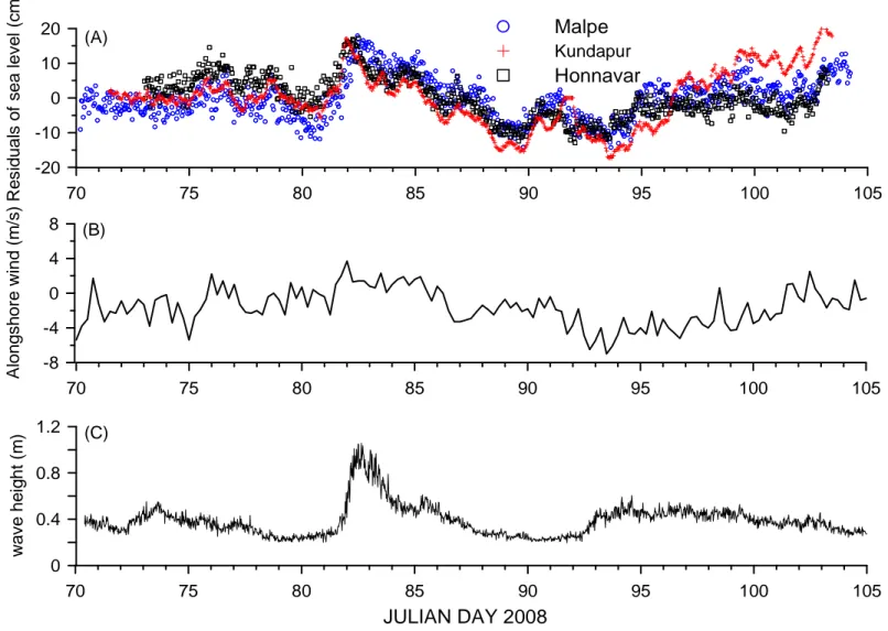
Strong winds on the water surface generate sea waves that can affect the water level. A Datawell directional waverider buoy was deployed off Honnavar within 0.5 km distance from the deployed tide gauge. The significant wave height measured by the buoy was compared with the residuals of sea level (Figure 4c). It was found that during Julian day 82 to 84, there was an increase in wave height and it has contributed to the rise in sea level.
4. Conclusions
Sea level data collected at 3 locations reveals that astronomical tides are responsible for most of the observed sea level variability during the pre-summer monsoon period along the Karnataka coast. During the measurement period, 97% of variation in measured sea level was due to tide at Honnavar and Malpe and 96% of sea level variation were due to tide at Kundapur. The residuals of sea level upto 18 cm were measured and were due to atmospheric forcing. When the alongshore wind from south was strong, a rise in sea level was observed and when the wind from north was strong, a fall in sea level was observed. The amplification of tidal constituent M2 and S2 from Malpe to Honnavar is 1.17, whereas the amplification of K1 is 1.07 and that of O1 is 1.09. The amplification of shallow water constituent M4 from Malpe to Honnavar is 1.39 and that of MS4 is 1.33.
5. Acknowledgments
1 2 3 4 5 6 7 8 9 10 11 12 13 14 15 16 17 18 19 20 21 22 23 24 25 26 27 28 29 30 31 32 33 34 35 36 37 38 39 40 41 42 43 44 45 46 47 48 49 50 51 52 53 54 55 56 57 58
6. References
Bell, C., Vassie, J.M., Woodworth, P.L., 2000. POL/PSMSL Tidal Analysis Software Kit 2000 (TASK-2000), Permanent Service for Mean Sea Level, CCMS Proudman Oceanographic Laboratory, Bidston Observatory, Birkenhead, Merseyside L43 7RA, U.K.
Emery, W.J., Thomson, R.E., 1998. Data Analysis Methods in Physical Oceanography. London: Pergamon Press, 634p.
Kalney, E., and Coauthors, 1996: The NCEP/NCAR 40-Year Reanalysis Project. Bulletin American Meteorological Society, 77, 437–471.
Nayak, R. K. and Shetye, S. R., 2003. Tides in the Gulf of Khambhat, west coast of India, Estuarine Coastal Shelf Sciences, 57, 249–254.
Prandle, D., 1997. Tidal and wind driven currents from OSCR, Oceanography, 10 (2), 57-59.
Pugh, D.T., 1987. Tides, Surges and Mean Sea Level. Chichester: John Wiley and Sons, 472p.
Shankar, D., 2000. Seasonal cycle of sea level and currents along the coast of India. Current Science, 78(3), 279–288.
Shetye, S. R., 1999. Tides in the Gulf of Kutch, India. Continental Shelf Research, 19, 1771–1782.
Srinivas, C., Revichandran, P.A., Maheswaran, T.T., Mohammed Ashraf and Murukesh, N., 2003. Propagation of tides in the Cochin esturine system, southwest coast of India. Indian Journal of Marine Sciences, 32(1) 14-24.
1 2 3 4 5 6 7 8 9 10 11 12 13 14 15 16 17 18 19 20 21 22 23 24 25 26 27 28 29 30 31 32 33 34 35 36 37 38 39 40 41 42 43 44 45 46 47 48 49 50 51 52 53 54 55 56 57
Sundar, D. and Shetye, S. R., 2005. Tides in the Mandovi and Zuari estuaries, Goa, west coast of India. Journal of Earth System Sciences, 114(5), 493–503.
1 2 3 4 5 6 7 8 9 10 11 12 13 14 15 16 17 18 19 20 21 22 23 24 25 26 27 28 29 30 31 32 33 34 35 36 37 38 39 40 41 42 43 44 45 46 47 48 49 50 51 52 53 54 55 56 57 58
Figure captions
Figure 1. Locations of measurement of sea level
Figure 2. Variation of measured sea level and tide at (A) Malpe, (B) Kundapur and (C) Honnavar
Figure 3. Amplitude and phase angle of tidal constituents for locations Malpe (M),
Kundapur (K) and Honnavar (H). (A) and (D) are semi-diurnal constituents, (B) and (E) are diurnal constituents and (C) and (F) are shallow water constituents
Figure 1. Locations of measurement of sea level
70 75 80 85 90 95 100 105 -150
-100 -50 0 50 100
S
e
a
l
e
v
e
l
(c
m
)
MEASURED SEA LEVEL TIDE
70 75 80 85 90 95 100 105
-150 -100 -50 0 50 100
S
e
a
l
e
v
e
l
(c
m
)
70 75 80 85 90 95 100 105
JULIAN DAY -150
-100 -50 0 50 100
S
e
a
l
e
v
e
l
(c
m
)
(A) MALPE
(B) KUNDAPUR
(C) HONNAVAR
0 10 20 30 40
0 20 40 60
A
m
p
lit
u
d
e
(
c
m
)
M2
S2
N2 L2
M K H K1
O1
J1 M1
M K H
LOCATION
120 140 160 180 200
P
h
a
s
e
(
d
e
g
)
M2 S2
N2 L2
M K H
LOCATION
320 324 328 332 336 340
M K H K1
J1 O1
0.5 1 1.5 2
M4
MS4
MN4
M K H
LOCATION
0 40 80 120
M4
MS4
MN4
M K H M1
(A) (B) (C)
(D) (E) (F)
70 75 80 85 90 95 100 105 -8
-4 0 4 8
A
lo
n
g
s
h
o
re
w
in
d
(
m
/s
) 70 75 80 85 90 95 100 105
-20 -10 0 10 20
R
e
s
id
u
a
ls
o
f
s
e
a
l
e
v
e
l
(c
m
)
Malpe Kundapur Honnavar
70 75 80 85 90 95 100 105
JULIAN DAY 2008 0
0.4 0.8 1.2
w
a
v
e
h
e
ig
h
t
(m
)
(A)
(B)
(C)
Table 1. Tidal constituents based on measured data at Malpe, Kundapur and Honnavar
Constituent Speed (deg/hr)
Malpe (stn. C1) Kundapur (stn C2) Honnavar (stn C3) Amplitude
(cm)
Phase (deg)
Amplitude (cm)
Phase (deg)
Amplitude (cm)
Phase (deg)
Q1 13.4 2.8 352 2.9 4 2.9 345
O1 13.9 13.7 333 14.4 333 15.0 335
M1 14.5 0.8 336 0.7 333 1.0 340
K1 15.0 29.0 334 30.2 335 31.0 334
J1 15.6 1.8 328 2.3 321 2.1 328
OO1 16.1 1.5 10 1.7 18 1.7 18
MU2 28.0 0.1 356 0.2 284 0.2 355
N2 28.4 10.2 127 10.9 130 11.9 127
M2 29.0 44.3 150 47.7 153 51.6 149
L2 29.5 1.2 166 1.0 166 1.3 161
S2 30.0 16.1 184 17.3 186 18.9 180
2SM2 31.0 0.2 146 0.2 145 0.2 152
MO3 42.9 0.2 42 0.2 57 0.1 82
M3 43.5 0.4 17 0.4 14 0.3 32
MK3 44.0 0.1 78 0.2 90 0.0 179
MN4 57.4 0.9 13 1.0 24 1.0 24
M4 58.0 1.3 64 1.6 64 1.8 64
SN4 58.4 0.3 10 0.4 40 0.4 36
MS4 59.0 0.9 116 1.2 119 1.2 115
2MN6 86.4 0.1 252 0.0 298 0.2 292
M6 87.0 0.2 327 0.2 311 0.2 289
MSN6 87.4 0.1 292 0.2 241 0.5 229
2MS6 88.0 0.2 49 0.3 317 0.7 295
2SM6 89.0 0.1 22 0.3 35 0.7 30